
Walking Pattern Recognition Explained for Indoor Navigation
A blind traveller in a busy rail interchange doesn't need another map pinned to a wall. They need the phone in their pocket to understand the movement they're already making, then turn that motion into the next precise instruction. That is where walking pattern recognition matters, not as a surveillance trick, but as the motion layer behind step-accurate indoor navigation.
In practice, the field sits between two very different questions. One is, “Who is this person by the way they walk?” The other is, “How does this device know the person has started walking, kept walking, changed pace, or turned into a corridor?” The first is the classic biometric meaning of gait recognition, the second is the accessibility and navigation problem that matters in stations, campuses, hospitals, malls, and underground spaces.
A major peer-reviewed survey makes that split clear, noting that gait has been used in research and in criminal cases, and that the field supports both person identification and medical assessment of Parkinsonian shuffle patterns (Connor, Ross, CVIU survey). The same body of work also shows why this topic is technically interesting but operationally messy. Modern deep-learning approaches have exceeded 97% accuracy on some benchmark datasets, while the mean accuracies in reviewed studies ranged from 62.3% to 97.6% depending on capture conditions and datasets (Connor, Ross, CVIU survey). That spread is the core point, because it tells you accuracy depends on environment, view angle, and walking context.
For an accessibility system, the useful question is narrower. Can a phone, with no installed hardware, detect motion well enough to keep a traveller oriented at walking pace? If the answer is yes, then the device can support wayfinding without forcing a person to scan a QR code, join a beacon network, or hand over control to a camera system. Waymap's own smartphone navigation work sits in that part of the problem space, where walking motion becomes a route primitive rather than an identity primitive, and where the practical value is independence, not surveillance (Waymap smartphone navigation).
What Walking Pattern Recognition Means in Practice
A blind commuter steps off a train, hears platform noise bouncing off glass and steel, and needs the next instruction before the crowd shifts around them. The system does not need to recognise their face, and it does not need to know their name. It needs to recognise that the phone is moving in a way that means “walking”, then keep updating position from that motion.
That distinction is easy to blur in public discussion. Gait recognition is the biometric field, useful for identifying a person from how they walk. Walking pattern recognition for navigation serves a different job, because the aim is to detect movement state, direction changes, and stride rhythm so the app can guide someone step by step. The mechanics overlap, but the purpose does not. One is about identity. The other is about motion continuity.
For accessibility, that difference matters in practical settings such as stations, large venues, and underground spaces. Those are places where a system has to work at a distance, without cooperation, and without installed hardware nearby. The same properties that make walking-pattern systems attractive for access control, security, and movement monitoring also make them useful for inclusive navigation. A person should not have to wait for a site to be retrofitted before their phone can help them move.
The term can still mean several things at once. A system may be detecting that a person has started walking. It may be estimating cadence. It may be using stride information to infer position drift. Or it may be building a long-term personal walking signature. The right interpretation depends on the use case, and navigation systems need to stay focused on motion, not identity.
Practical rule: if the product must help someone reach a door or platform, treat walking recognition as a navigation signal first, and a biometric signal only if the application requires it.
The implementation side matters too. Walking recognition in mobile and wearable systems usually relies on the device's own inertial sensors, then classifies motion by analysing the signal shape or the signal features. That is why this topic matters for indoor navigation in the first place, because the phone can infer movement even when GPS, Wi-Fi, and fixed hardware are unreliable or absent. For a closer look at the smartphone side of this approach, see Waymap's smartphone navigation work.
The Core Building Blocks From Step to Stride to Signature
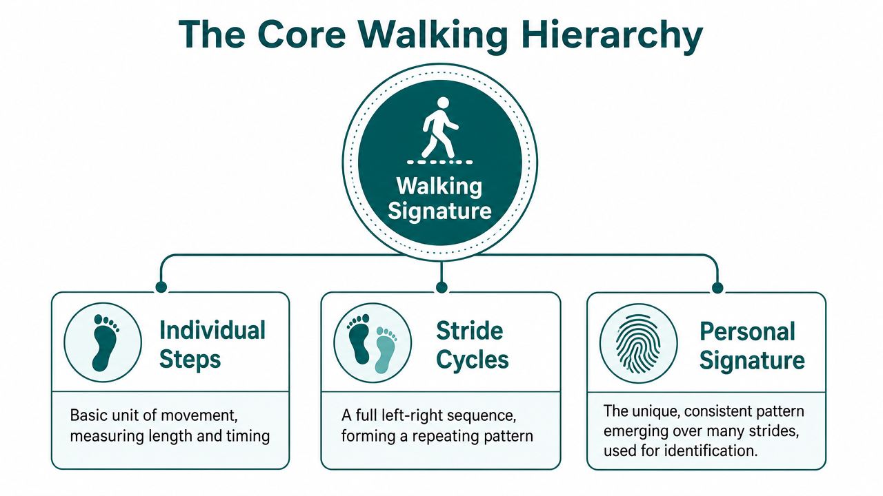
A person does not move in a single block of “gait.” The signal arrives in layers. A step is the smallest useful unit, a stride cycle shows how those steps relate to one another, and a longer walking pattern shows what stays stable across time. For step-accurate navigation, that hierarchy matters because each layer answers a different question. A step says movement happened. A stride cycle says the rhythm is repeating. A broader signature says the pattern is consistent enough to support recognition or calibration.
Why step length matters so much
For dead reckoning, step length is the variable that most directly changes estimated position. Cadence tells you how often a person steps, while step length tells you how far each step carries them. Two people can move at the same pace and still cover different distances if one takes shorter steps. That is why a system that only counts steps will drift quickly in a complex building, while a system that models stride length and timing can keep guidance tighter.
A useful comparison is a metronome with a ruler attached. The metronome gives timing, the ruler gives distance, and both are needed if you want to estimate where someone is after several turns. Walking pattern recognition uses motion cues in that combined way, not as a single magic number.
What a walking signature contains
At the signal level, the common features are plain enough: step time, step length, cadence, and vertical acceleration amplitude. Together they form a personal walking signature. That signature can be updated on device as a person's movement changes through the day, which matters because nobody walks with identical rhythm from breakfast to late evening.
A person may slow down in a crowded concourse, shorten stride on stairs, or change arm carriage when holding luggage. If the system is useful for navigation, it has to adapt to those shifts rather than treating them as noise to be ignored. Calibration matters more than a generic model.
For the device layer, this becomes an IMU problem. A smartphone's motion sensors capture the raw inputs, then the software turns those inputs into structured movement estimates. Waymap's sensor navigation overview shows how that motion-led approach is built around the device's own inertial sensors, rather than installed beacons or hard-coded assumptions about walking speed.
The most common mistake is to treat walking as a single feature. It isn't. It is a stack of timing, distance, and pattern stability.
How Smartphones Turn Motion Signals Into Recognised Walking
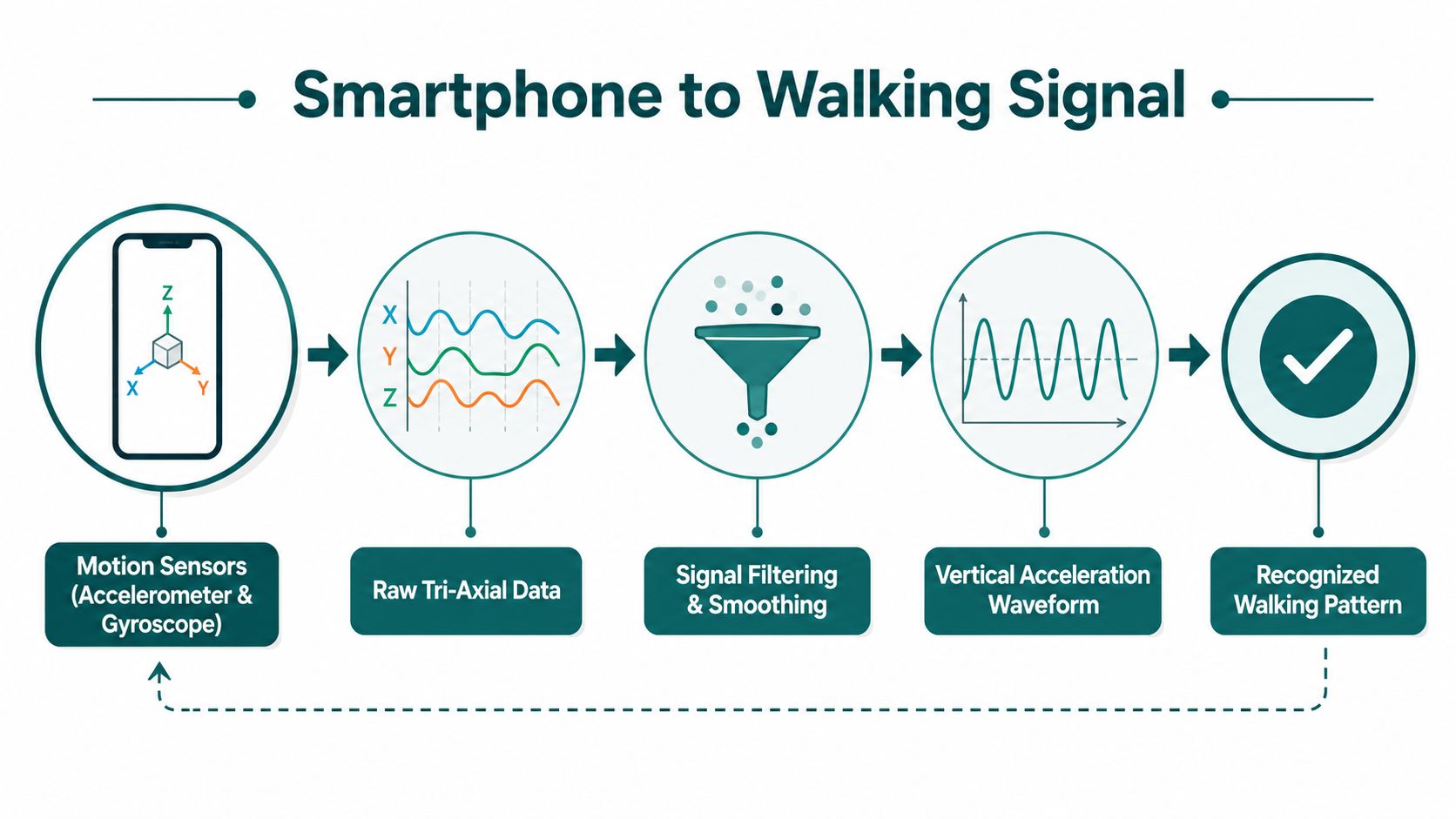
A phone in a pocket, on a lanyard, or in the hand is always reading motion through its tri-axial accelerometer and gyroscope. Those sensors produce a noisy stream, and the engineering task is to turn that stream into a walking signal that still holds together when the phone rotates, swings, or changes position.
The first stage is usually preprocessing. The software filters the raw motion, lines up the axes, and marks the parts of the signal that are likely to contain steps. That orientation handling is the point where a sensor fusion algorithm matters, because the device has to combine motion cues before it can make a stable walking decision. Waymap's sensor fusion algorithm overview describes that kind of device-side correction in more detail.
A common detection chain starts with peak-valley detection to find heel-strike events in the vertical acceleration signal. From there, the software compares step cycles with representative patterns using a distance metric, and warped distances such as DTW help decide whether the motion corresponds to walking (review of mobile walking recognition). Heel strike gives the pipeline a clear anchor in the waveform, so the phone can often detect the step even when the user changes how they carry the device.
Feature-based and shape-based pipelines
Two model families dominate the mobile side. Feature-based methods calculate statistics from the time and frequency domains, then pass those features to a classifier. Shape-based methods compare the waveform shape itself against known patterns. The mobile review notes that a simple CNN using the norm of acceleration in the mobile frame performed best in one feature-based approach, while Random Forest stayed competitive when manual feature selection was used (mobile walking recognition review).
For navigation, preprocessing matters as much as the classifier. The algorithm needs to normalise sensor orientation, verify high-amplitude segments, and use frequency-domain features to reject non-walking motion. Without that work, the phone can confuse a chair adjustment, a bus brake, or a bag swing with a step. Reliable walking recognition is an engineering pipeline, not a single model choice.
The evidence base supports the device-first approach. A 2024 peer-reviewed study found average walking-recognition sensitivity between 0.92 and 0.97 across smartphone, smartwatch, and wearable accelerometer placements, with specificity for common daily activities typically above 0.95 (Nature Communications paper). Another clinical engineering study using a single foot-mounted gyroscope reported 93 ± 4% accuracy, 76 ± 17% precision, 98 ± 2% sensitivity, and 91.5 ± 4% specificity, while the best adaptive-threshold method reached 98% sensitivity and 91% specificity (PMC foot-IMU study).
For a device running in a crowded station, those results matter because they show walking can be recognised without dedicated site hardware. For Waymap's motion-fusion approach, that is the base that lets the app turn ordinary smartphone movement into guidance, without depending on beacons or GPS.
Engineering note: if the phone's orientation changes, the model has to compensate before the walking decision is made. Otherwise the same walk can look like different motions.
Algorithms and Model Types Used for Walking Pattern Recognition
A hallway example makes the choice concrete. A phone can need one model to notice a step, another to compare a stride pattern, and a third to turn those signals into a navigation decision. The right family depends on where the model sits in the stack and what failure would cost the user.
What each model family is good for
Heuristic peak-valley detectors work well for fast step events. They are simple, easy to inspect, and suited to immediate motion triggers. Adaptive thresholds extend that approach by letting the detector adjust to changing amplitude instead of assuming one fixed walking style.
Template matching with dynamic time warping fits cases where the system needs to compare step cycles that are similar but not perfectly aligned. It can match the same walk shape even when cadence shifts, because it compares the timing pattern rather than requiring every sample to line up exactly.
Random Forest and SVM sit in the classical machine-learning middle ground. They work well after the pipeline has turned raw motion into features, and they are often easier to run on constrained devices than heavier deep models. The feature-based findings in the mobile walking recognition review help explain the trade-off, a simple CNN could outperform some alternatives, while Random Forest stayed competitive when manual feature selection was strong.
Deep learning becomes attractive when the system has richer context or when the recognition task needs to learn from more varied motion patterns. Benchmark gait systems often report strong scores on controlled datasets, including modern deep-learning methods exceeding 97% accuracy in some cases, as summarized in the Connor, Ross survey. Those results only matter if deployment conditions stay close enough to training conditions.
Waymap's approach is relevant because it does not rely on one model class for the entire job. The system combines the smartphone's native motion sensors with map data, so the navigation layer can keep working even when the environment is signal-poor and the walking pattern changes as the route changes. For the broader system view, Waymap's navigation workflow overview shows how those pieces fit together.
Why Generalisation Is the Hard Problem Most Claims Miss
A model can look strong in a controlled test and still break in a concourse. The reason is simple. People do not walk the same route every time, and each route changes the motion pattern the model has to read. That is the part many headline accuracy claims leave out.
Straight paths are not the whole story
One practical study reported 98% correct classification for straight-to-straight walking, but only 81% for straight-to-curved matching, and about 80% when enrollment and recognition used different trajectories (trajectory study). Those results are not a minor statistical wrinkle. They show the difference between a clean benchmark and a live station interchange.
The question is whether a model still recognises movement when the user turns, slows for a lift, changes corridor, or crosses from indoor to outdoor space. That matters in transport hubs, campuses, and shopping centres, where route variability is normal and the same person may follow a different path from one visit to the next. Waymap's the blue dots approach exists because route context changes the problem. A system for step-accurate guidance has to keep working when the path is not fixed.
Practical rule: never trust a walking-recognition number unless you know whether it was measured on the same path, the same session, or the same environment.
Why inclusive design raises the bar
Generalisation is also where accessibility enters the picture. A system tuned only on ideal walking styles may not behave well for older adults, people with mobility differences, or users whose gait changes over the course of a day. Research on gait perception shows that some asymmetric or pathological gait patterns can still be perceived as normal, with step time and step length asymmetries under 5% and cadence changes of 25% often not noticed, and asymmetry below roughly 15% may be hard to distinguish from a normal gait (gait perception review). That does not mean a navigation model should copy human perception. It means walking is variable enough that inclusive evaluation has to include non-ideal movement.
The same accessibility gap shows up in biometric studies. A Scientific Reports paper on 81 adults found very high individual identification accuracy with IMU data, including 98.63% for random forest and 95.47% multi-day identification (Scientific Reports gait study). Another walking-fingerprint paper reported 95%+ rank-1 accuracy in a 32-person dataset, but much wider performance spread in a 153-person dataset, ranging from **41% to 98% depending on the method and task (walking-fingerprint study). Those numbers show persistence and variability at the same time, which is exactly why route-aware testing matters more than a single benchmark score.
For a blind traveller, the issue is practical. A model that works only on one corridor configuration may be fine for a demo. It is less useful for the regular person who arrives through one entrance, leaves through another, or has a route changed by temporary barriers. That is also why infrastructure-free navigation matters for an exhibit builder like ucon, where layouts change and the route has to be read from the current space, not from a fixed hardware grid.
Waymap's design choice is to treat route variability as the constraint, not the exception. That is the difference between a model that recognises a laboratory walk and one that can support a blind traveller in a live building.
From Algorithms to Deployments in UK Venues and Transit
A venue team does not adopt walking recognition because it is an abstract model. It adopts it because people need reliable guidance through places that change during the day, and sometimes between one visit and the next. In that setting, the harder problem is often not the first install. It is keeping maps, points of interest, and supporting systems aligned with the site as it changes.
Where infrastructure-free navigation changes the operating model
Waymap's infrastructure-free approach matters for operators such as Westfield London, Lord's Cricket Ground (MCC), WMATA, and SBS Transit because it avoids the capital and maintenance burden of beacon hardware while still supporting route guidance in high-footfall settings. For NHS estates teams, that reduces the chance that a navigation project turns into a hardware approval process before it can be used. For university and airport facilities teams, it also means points of interest can be updated when layouts change, rather than waiting for site equipment to be reworked.
The test is not whether a beacon system can work in a controlled demo. The test is whether a live venue can keep it working after a shop unit changes, a concourse is reconfigured, or a platform area is revised. In those conditions, software updates are usually easier to govern than physical maintenance visits.
| Operator segment | Real friction point | What infrastructure-free navigation removes |
|---|---|---|
| Retail and shopping centres | Frequent store and corridor changes | Beacon maintenance and reinstallation |
| Transit operators | High-footfall, high-change environments | Site hardware dependency |
| Universities and campuses | Constant room and POI updates | Slow refresh cycles for fixed infrastructure |
| NHS estates teams | Capital approval and install complexity | Beacon deployment overhead |
For venue planners who already work with temporary structures and changing layouts, an external resource like exhibit builder services can serve as a useful comparison, because exhibition spaces show how often physical environments change and why software-led updates are easier to manage than hardware-led ones. The same logic applies to an exhibit builder working in a space where the route, signage, and points of interest may need to be revised repeatedly.
A separate deployment question is accuracy. In some product-specific implementations, sensor fusion is positioned to deliver sub-3-metre accuracy without Wi-Fi, GPS, or installed hardware, but that should be treated as a deployment target rather than a universal benchmark. In a venue where wayfinding depends on exact doors, platforms, or points of interest, that level of precision is operationally useful because it supports guidance at the scale people move through a building.
Privacy, Bias and Regulatory Obligations for Walking Pattern Recognition
Walking data becomes personal data very quickly when it is tied to identity or persistent movement patterns. In UK deployment terms, that means the privacy question isn't optional, and it shouldn't be buried in a later legal review after the technical design is already fixed.
The practical compliance shape
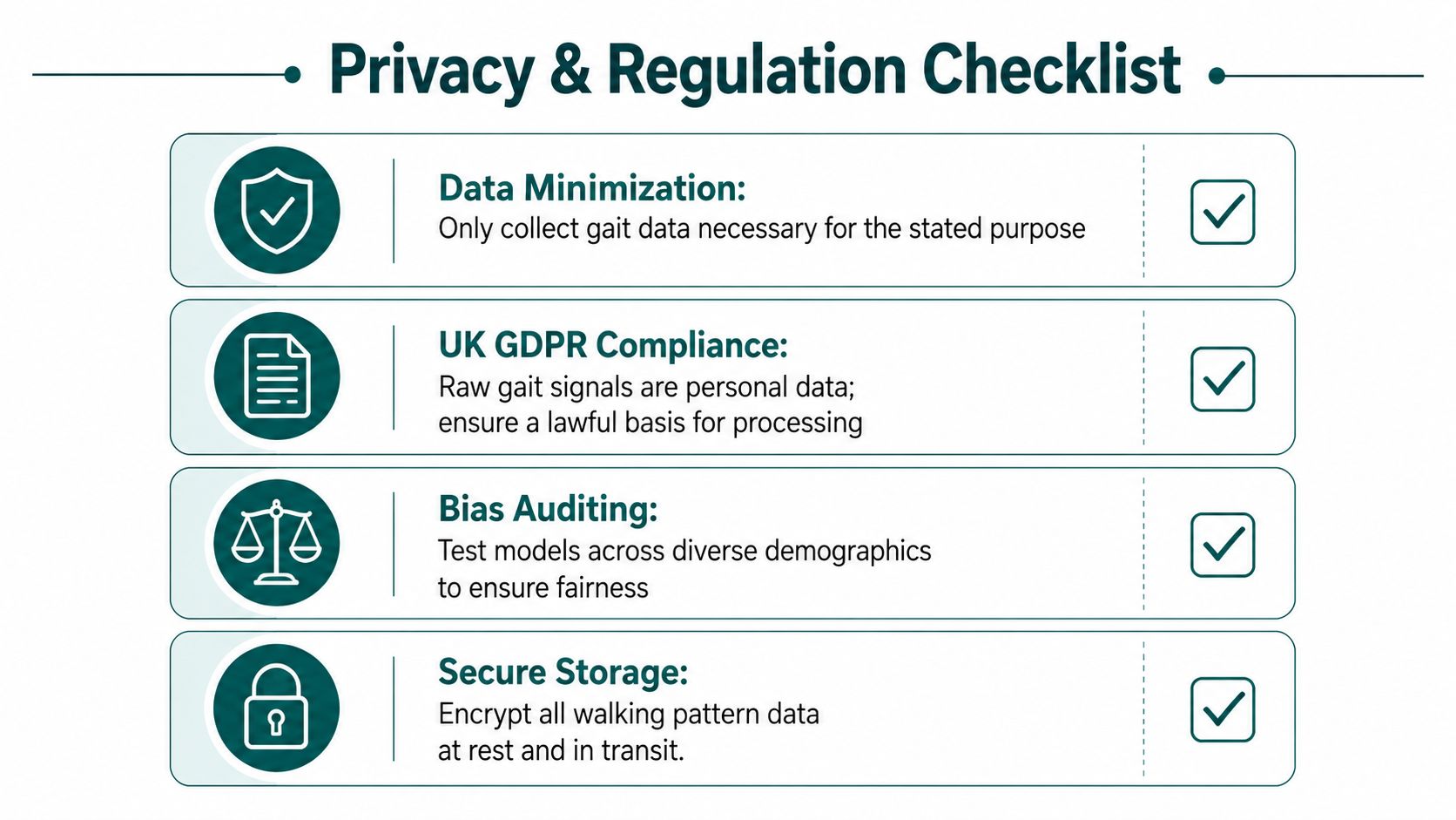
If a system uses raw gait signals to identify a person, those signals are personal data under UK GDPR. The safest technical pattern is on-device processing, because it keeps motion data local unless there's a specific reason to transmit it. That doesn't remove all obligations, but it does reduce exposure and simplifies the lawful-basis discussion.
Bias is the second constraint. If a walking-recognition model is tuned mainly on typical adult walking styles, it may perform less reliably on older adults, mobility-aid users, or people whose gait changes from day to day. For accessibility, that is not an edge case. It's the core deployment audience.
Equality Act 2010 duties matter here because a venue or operator can't treat accessibility as a nice-to-have layer once the system is live. BS EN 17210 also pushes the built environment toward accessibility that works in practice, not just on paper. A walking-based navigation system should therefore be tested on intentionally non-standard gait patterns, not only on idealised lab movement.
A simple deployment rule helps keep the project grounded:
- Minimise data: only collect what the navigation purpose needs.
- Prefer local processing: keep raw motion data on the device when possible.
- Audit across users: test with older adults and people with mobility differences.
- Document the purpose: don't blur navigation, analytics, and identification.
- Plan secure storage: if data must leave the device, protect it in transit and at rest.
The main point is practical. If a system can guide a person without storing their walking history centrally, it should. That is better for privacy, easier to defend under regulation, and more respectful of the user's autonomy.
Deployment Checklist and FAQs for Decision-Makers
A venue or transit team should ask six questions before they treat walking pattern recognition as deployable:
- Sensor coverage: Do the target devices have the motion sensors needed for reliable walking detection?
- Map quality: Are indoor maps and points of interest maintained well enough for route guidance?
- Route variability: Has the system been tested on curved routes, mixed indoor-outdoor movement, and real crowd conditions?
- Inclusive evaluation: Were older adults and users with mobility differences included in validation?
- Privacy posture: Can the system work with on-device processing and minimal data retention?
- Update workflow: Can points of interest be changed quickly when the venue layout changes?
Does walking pattern recognition require installed infrastructure? No, it can work without installed infrastructure when it uses the smartphone's native motion sensors and map data.
How well does it handle curved indoor routes? It performs worse when route conditions change, and one practical study reported about 80% accuracy when enrollment and recognition used different trajectories (trajectory study).
Does it work for users with mobility differences? It can, but only if the system is tested on non-ideal gait patterns instead of assuming one standard walking style.
What accuracy should a venue expect? Expect performance to vary by capture quality, route shape, and environment, because benchmark scores don't transfer cleanly into live buildings.
If you're planning an indoor navigation rollout for a station, campus, hospital, or retail site, talk to Waymap about how smartphone-based walking recognition can fit your accessibility and operations constraints without adding site hardware.
