
Unlock Efficiency with Real Time Transit Information
Meta description: Real time transit information improves certainty, cuts waiting, and supports better journey planning. But basic live feeds don't solve the last-metre accessibility gap inside stations, hospitals, airports, and other complex venues.
Most advice about real time transit information stops too early. It treats live arrival feeds as the finished product, when in practice they're only the front half of the journey.
For many passengers, seeing that a bus is due in a few minutes is useful. For a blind passenger in a large interchange, a rail customer trying to find the right platform entrance, or a visitor inside a hospital campus, that same update can be incomplete to the point of failure. If the system tells you when to move but not where to go, it hasn't solved the whole problem.
At Waymap, we see this gap repeatedly across transport and venue environments. Operators have improved their feeds, standardised their data, and connected to public apps. Yet the practical question inside complex spaces remains stubbornly unresolved: how does a person get from the entrance, concourse, or stop perimeter to the exact door, platform, boarding point, or service desk without guesswork?
The Hidden Gap in Real-Time Transit Information
The market has largely accepted a weak definition of success. If live bus and rail times appear in an app, many teams assume the accessibility problem is covered. It isn't.
The National Audit Office material around accessibility and journey time tools points to the issue directly. Existing content predominantly answers “when will the bus arrive?” but fails to address how real-time data improves accessibility compliance and ESG metrics. It also notes that RTPI reduces wait times by 15 to 20% for general users, while often failing to deliver equivalent value for disabled users who face last-metre navigation challenges that RTPI does not cover, as discussed in the NAO's work on transport accessibility to local services.

Why arrival data isn't the same as journey completion
A live feed is designed around stop-to-stop status. It tells passengers whether the vehicle is running, delayed, or approaching. That's valuable, but it doesn't describe the internal geography of a station, shopping centre, airport, or hospital.
That difference matters most in places where the final approach is the hardest part of the trip:
- Large interchanges: A passenger may know the bus is arriving but still not know which bay to use.
- Underground or signal-poor areas: The feed may remain accurate while positioning and orientation become harder for the user.
- Accessible route changes: A working lift, step-free entrance, or safer path may be different from the obvious route shown by public signage.
Real time transit information improves timing. It does not automatically provide usable wayfinding.
What operators miss when they only map the service
Transport teams often model the vehicle journey well and the pedestrian journey badly. Venue teams often do the reverse. Inclusive delivery needs both.
A useful way to frame this is through customer journey mapping in complex environments. The transport feed is one layer. The physical movement through the venue is another. Passengers experience them as one journey, not two systems owned by different departments.
What Is Real-Time Transit Information at Its Core
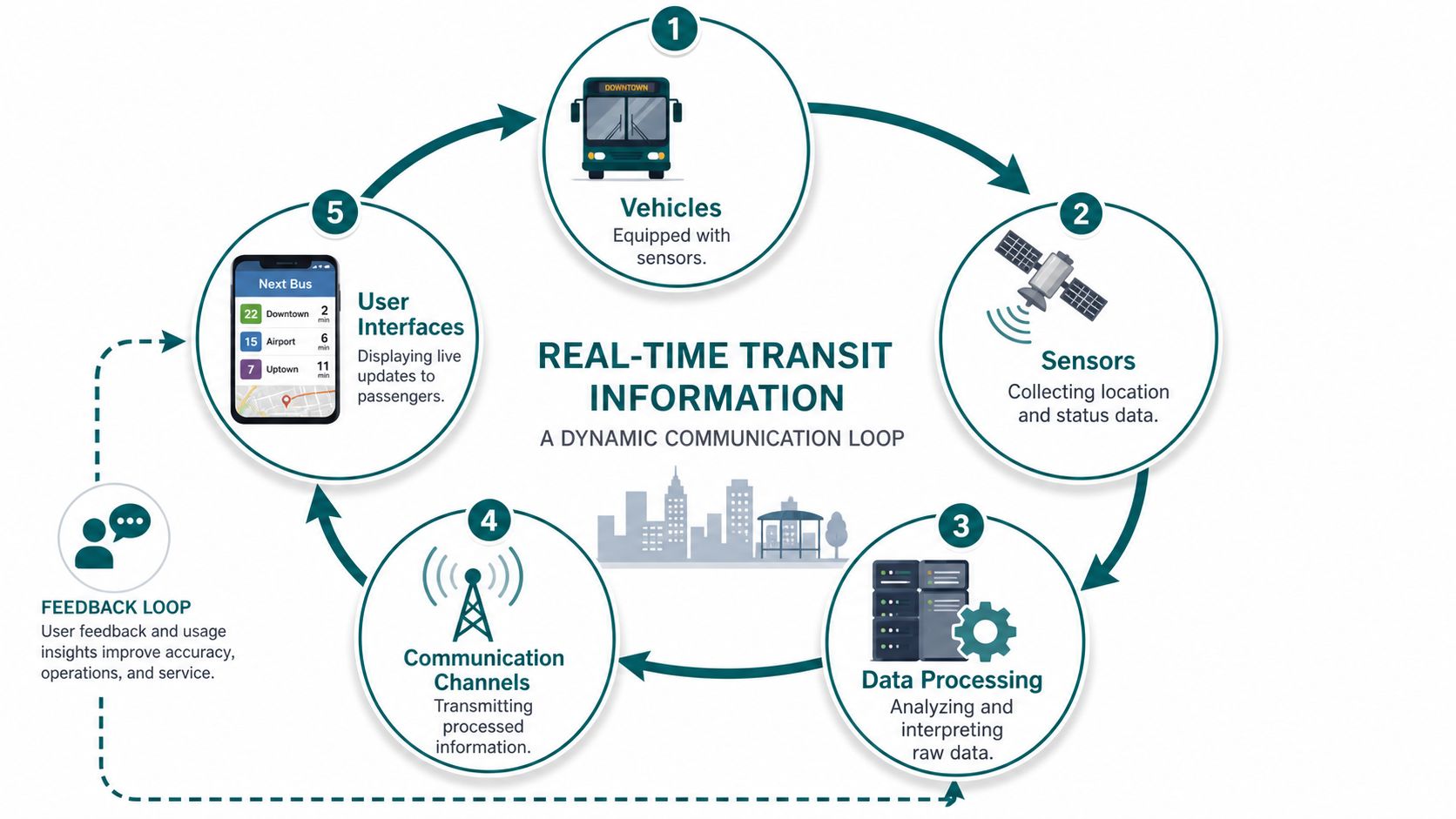
Real time transit information is a communication loop between a moving vehicle, a prediction engine, and a passenger-facing channel. It isn't just a countdown clock. It's an operational system that converts vehicle state into something a person can act on.
The three parts that matter
It's similar to restaurant order tracking. The kitchen knows where your order is in the process. The system estimates completion. The customer sees whether it's still being prepared or ready for collection.
Transit works in much the same way:
Vehicle telemetry
A bus or train reports its location and operating status through AVL and related onboard systems.Processing and prediction
Backend software compares live movement against timetable data, route logic, and service conditions.Passenger presentation
Apps, station screens, SMS services, and websites translate the raw feed into arrival times and alerts people can use.
In England, bus operators are now required to upload live location information to external platforms. That adoption of AVL and open data formats has been linked to an average two-minute reduction in actual rider wait times, as noted in discussion of the nationwide rollout of live UK bus tracking in Google Maps and related platforms.
What good RTI changes for passengers
The operational value of RTI is simple. It reduces uncertainty.
Passengers don't have to arrive blindly and hope. They can decide whether to walk now, wait indoors, change route, or use another service channel. In London, for example, passengers can use TfL's live bus arrivals SMS service by texting a stop code, and rail passengers can access current-day live information through National Rail TrainTracker.
Later in the journey, the same principle applies to every interface.
Where most explanations stop too soon
Most definitions of RTI focus on feeds, apps, and prediction quality. Decision-makers need a more useful view than that. They need to know what information reaches the passenger, when it reaches them, and whether it remains actionable in the place where they must make the next movement decision.
For a deeper primer on the operational side, see our piece on what real-time information means in practice.
How Do Transit Data Standards Actually Work
Data standards are the plumbing behind modern passenger information. When they're well implemented, operators can publish one authoritative stream and let many channels consume it consistently.
The role of GTFS and GTFS Realtime
GTFS handles the planned service. It describes routes, stops, trips, and timetables. It's the scheduled picture of the network.
GTFS Realtime adds the live layer. It carries vehicle positions, trip updates, and service alerts so passenger-facing systems can respond to current conditions rather than printed timetables.
In England, the Bus Open Data Service requires local bus services to publish data in GTFS-RT format. That supports second-by-second updates, with latency typically under 30 seconds for API consumers, and has been associated with a 15 to 20% reduction in passenger wait-time uncertainty in FTA-assessed transit systems, according to the UK government's guidance on bus open data.
Where SIRI fits
SIRI is another widely used standard, especially in European public transport environments. In practice, many organisations work with a mix of standards depending on legacy systems, regional procurement choices, and downstream app requirements.
The important point for operators isn't acronym preference. It's interoperability. A standard matters because it lets the network speak consistently to journey planners, station displays, websites, control rooms, and third-party developers.
Comparison of Key Transit Data Standards
| Standard | Data Type | Primary Use Case |
|---|---|---|
| GTFS | Static scheduled data | Publishing planned routes, stops, and timetables |
| GTFS-RT | Live operational updates | Sharing vehicle positions, arrival predictions, and disruption alerts |
| SIRI | Real-time public transport messaging | Exchanging live service and operational information across systems |
What standards do well and what they don't
The standards solve a hard industry problem. They make live service data portable and reusable. That's why platforms such as Transport for London and Transport for West Midlands can expose network information to many interfaces without rebuilding the feed each time.
But they were not designed to answer hyperlocal pedestrian questions inside a venue.
They can tell a passenger that a service is arriving at Stop B, Platform 4, or Bay 12. They do not usually tell that passenger how to find the precise boarding point from a station entrance, through a concourse, past temporary barriers, and around a lift outage.
Operational rule: Treat standards such as GTFS-RT as the transport data layer, not the complete accessibility layer.
That distinction becomes critical in interchanges, hospitals, stadiums, and retail destinations where the passenger's final navigation decision happens after the feed has already done its job.
Why Standard Real-Time Data Fails Blind and Low-Vision Users
A standard feed can be accurate and still be inaccessible in practice.
That isn't a contradiction. It's a design limitation. Real-time transit systems were built to report service state, not to guide a person through the fine-grained physical environment around that service.
The problem is hyperlocal, not network-wide
Parliamentary discussion on real-time bus information in the North East captured a point operators often miss. Despite mandates for accurate vehicle location data, there remains a significant gap in hyperlocal reliability for blind and low-vision users. The discussion cites ONS analysis showing that public transport data often fails to capture micro-differences in accessibility within stations, leaving disabled users without guidance on finding the exact boarding point, as set out in the House of Commons debate record.
For a sighted passenger, “your bus is due” may be enough. For a blind passenger, the unanswered questions are often the decisive ones:
- Which entrance is step-free or less obstructed
- Where the boarding point sits relative to tactile paving or shelter lines
- How to reach the correct platform without relying on visual landmarks
- What to do when temporary changes alter the usual path
Why compliance can't stop at publishing data
Under the Equality Act 2010, operators and venue managers can't treat accessibility as a thin digital layer over an otherwise inaccessible journey. If the practical result is that one group can independently complete the trip and another can't, the service still falls short.
The same issue appears against broader accessibility standards and obligations, including BS 8300, PAS 78, BS EN 17210, and the UN Convention on the Rights of Persons with Disabilities. None of these frameworks are satisfied by countdown data alone. They point toward usable access to the environment, not merely publication of service information.
Why infrastructure-heavy fixes often stall
Many teams recognise the gap and jump to beacons, Wi-Fi triangulation, or physical hardware refreshes. Those can work in limited cases, but they create a maintenance burden that transport operators and venue estates teams often underestimate.
High-footfall spaces change constantly. Retail units move. Temporary hoardings appear. Platform access routes shift. In hospitals and stations, staff turnover and layout changes make hardware-dependent navigation harder to keep current.
A different approach uses dead reckoning with device-native smartphone sensors to guide the user through infrastructure-free environments, including places where GPS and Wi-Fi are unreliable. That model is especially relevant for indoor, underground, and interchange spaces because it avoids turning every accessibility improvement into a hardware project.
For context on why smartphone-based guidance matters for blind users in daily travel, see our article on smartphone navigation for visually impaired people.
If the last metre is inaccessible, the whole journey is inaccessible.
How to Build a Truly Inclusive Real-Time Information System
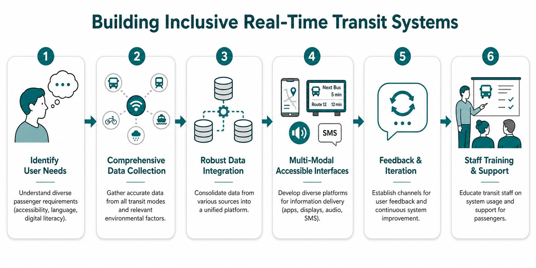
A workable inclusive architecture doesn't replace your existing RTI stack. It adds the missing pedestrian layer and makes the handoff between live service data and physical navigation explicit.
Start with the feed you already trust
Most operators already have the foundation. Bus and rail systems publish live updates through GTFS-RT, SIRI, or equivalent interfaces. Keep that layer authoritative for service status, arrival predictions, and disruption messaging.
The mistake is trying to make that feed do everything. It shouldn't. Let the transport data answer vehicle questions.
Add a navigation layer for the passenger environment
The next layer should answer pedestrian questions inside and around the venue:
- Entry choice: Which entrance is appropriate for this user and this destination?
- Route logic: Which path remains usable if lifts, escalators, or barriers change the obvious route?
- Boarding precision: Where is the exact bay, platform edge, or door position the user needs?
For operators assessing the technical side of fleet and sensor infrastructure, Sheridan Technologies' IoT insights are useful background on how connected transport systems are evolving. But vehicle connectivity and venue navigation are different layers of the same passenger experience. One doesn't remove the need for the other.
Fuse both layers at the decision point
The handoff matters more than the components.
A strong implementation doesn't merely show a countdown and then open a separate map. It connects the timing event to the movement instruction. If a bus is close, the passenger should receive route guidance that reflects the remaining walk, current access constraints, and the exact destination point.
That means product teams need shared ownership across transport operations, digital, accessibility, and estates.
Choose deployment models that operations teams can maintain
Infrastructure-free indoor navigation is often the practical choice because it avoids the recurring burden of installed hardware across changing environments. One approach is Waymap, which uses dead reckoning from device-native sensors for guidance indoors, outdoors, and underground, including exact doors, platforms, and points of interest without relying on GPS, Wi-Fi, or installed beacons. For transport operators and venues, that matters because layout changes can be updated in software rather than through on-site hardware maintenance.
Build for mixed channels, not just one app
Inclusive delivery usually needs several outputs working together:
- Mobile app guidance for passengers who use smartphones independently.
- Audio-first interaction for blind and low-vision users who need heads-up instructions rather than visual map reading.
- Staff-facing visibility so frontline teams understand what route the digital system is recommending.
- Fallback channels such as SMS, web, and customer support for passengers who don't use the main app.
Teams designing these experiences should pay close attention to adaptive user interface patterns for different accessibility needs. A good interface doesn't just expose more information. It presents the next action in the right mode for the user.
Measuring the Impact on Ridership and Accessibility
Operators usually ask the wrong first question. They ask whether inclusive RTI will increase ridership. A better question is whether it improves the quality, defensibility, and usability of the service.

Research summarised by Real Time Transit Information reports that 92% of riders using RTI said they were more satisfied with their transit service. The same source notes that RTI supports data-driven planning, can boost ridership, and increases feelings of safety for passengers. Those are strong indicators, but they aren't the whole scorecard for accessibility-led deployments.
The KPIs that matter in practice
A stronger measurement framework combines passenger, operational, and compliance indicators.
- Accessibility-related complaints: Track whether passengers continue to report problems finding platforms, entrances, lifts, or boarding points.
- Task completion: Measure whether users can independently complete common journeys through the venue without staff intervention.
- Satisfaction by user group: General satisfaction matters, but disabled user feedback should be analysed separately rather than diluted into a network-wide average.
- Operational burden: Review whether the solution creates extra maintenance work for estates, digital, or station teams.
- Audit readiness: Assess whether the system produces evidence that supports accessibility and ESG reporting.
What venue managers should expect
For airports, hospitals, stadiums, and retail destinations, the value often shows up before it appears in ridership figures. The immediate gains are usually fewer wayfinding failures, less pressure on frontline staff, and clearer evidence that the venue is addressing access barriers in a structured way.
A useful RTI deployment doesn't just tell you whether the feed is accurate. It shows whether people can complete the journey the feed implies.
Why retention data belongs in the conversation
A navigation feature that passengers try once and abandon hasn't solved much. Usage patterns after launch can reveal whether instructions are clear, whether routes stay current, and whether users trust the system enough to return to it.
That's why product and operations teams should review user retention metrics for accessibility tools alongside customer feedback and service data. The goal isn't novelty. It's repeatable independence.
Frequently Asked Questions About Implementing Advanced RTI
What is real time transit information in practical terms
Real time transit information is live operational data that tells passengers what a service is doing now, not just what the timetable said earlier. In practice, that includes vehicle location, predicted arrivals, and disruption messaging delivered through apps, displays, SMS, and other channels.
Does real time transit information solve accessibility on its own
No. It improves timing and reduces uncertainty, but it doesn't automatically guide a person through the last metre inside a station, airport, hospital, or other complex venue.
What's the main implementation mistake operators make
They treat the feed as the product. The feed is only one layer. Passengers still need route guidance from the entrance or interchange point to the exact boarding or destination location.
Do we need to replace our current RTI systems
Usually not. Most organisations should keep their existing feed architecture and add a navigation layer that handles indoor, underground, and hyperlocal pedestrian guidance.
Is hardware always necessary for precise navigation
No. Infrastructure-free approaches can avoid the cost and maintenance burden of beacons and similar installed hardware, which is especially important in high-change environments.
How should a venue manager judge success
Judge success by whether people can complete journeys more independently and whether the organisation can evidence better accessibility performance. Complaints, task completion, user feedback, and operational maintenance effort are often more useful than a headline app-download number.
Can advanced RTI work inside an existing passenger app
Yes. In many deployments, the practical route is to integrate navigation capability into the organisation's existing digital estate through an SDK or similar component, rather than forcing passengers to adopt a separate workflow.
If your organisation has strong live service data but still struggles with the last-metre journey, Waymap can help you assess what an infrastructure-free navigation layer would look like across stations, campuses, hospitals, retail sites, and other complex venues.
