
What Is Real Time Information

A station concourse looks orderly until something changes. A platform alters at short notice, a lift goes out of service, or a queue starts forming where the map says there should be a clear route. At that point, the difference between useful information and decorative information becomes obvious.
For operations teams, real time information matters when people need to act on it immediately. That might mean passengers choosing a different entrance, staff redirecting footfall, or a blind traveller relying on audio instructions that reflect the environment as it is now, not as it was a few minutes ago.
What Is Real Time Information?
Real time information is data delivered quickly enough to support an immediate decision or action. In a public-facing environment, that usually means information that reflects current conditions closely enough for passengers, visitors, and staff to rely on it.
A simple example is a station customer checking whether the next train is on time. A more demanding example is someone navigating through a complex interchange after a last-minute platform change. In both cases, the user doesn't need a historical report. They need current, actionable information.
The UK's clearest foundational definition comes from the Office for National Statistics. The ONS says it uses large-scale, near-real-time administrative and commercial data sources to complement traditional statistics and track the economy more quickly than monthly or quarterly releases, as outlined in this overview of real-time data and the ONS definition. The same source notes that the ONS COVID-19 Infection Survey published results on a weekly basis and reached around 150,000 people at its peak, which shows why reducing delay between events and reporting has operational value.
What real time information looks like in practice
In venues and transport settings, real time information often includes:
- Service status updates that reflect disruption, closures, or temporary restrictions
- Arrival and departure information that changes as vehicles move
- Access updates such as lift outages, closed entrances, or route diversions
- Wayfinding instructions that remain aligned with current conditions
That last category is where many operators run into problems. A map can be correct in principle and still fail in practice if it doesn't adapt to what the visitor is encountering.
Practical rule: If a user can act on the information immediately, its timing becomes part of its quality.
Why the definition matters operationally
Operations directors usually don't need a philosophical definition. They need to know what standard they're buying against. Real time information isn't just “fast data”. It's information delivered soon enough to improve service, reduce confusion, and support operational response.
That's also why static wayfinding and internal navigation systems have been giving way to dynamic models that can be amended without replacing physical infrastructure, as seen in this internal navigation system approach.
How Is Real Time Information Produced and Delivered?
Most real time information systems follow a simple path. Collect data, process it quickly, deliver it to the point of use. The complexity sits underneath that sentence.
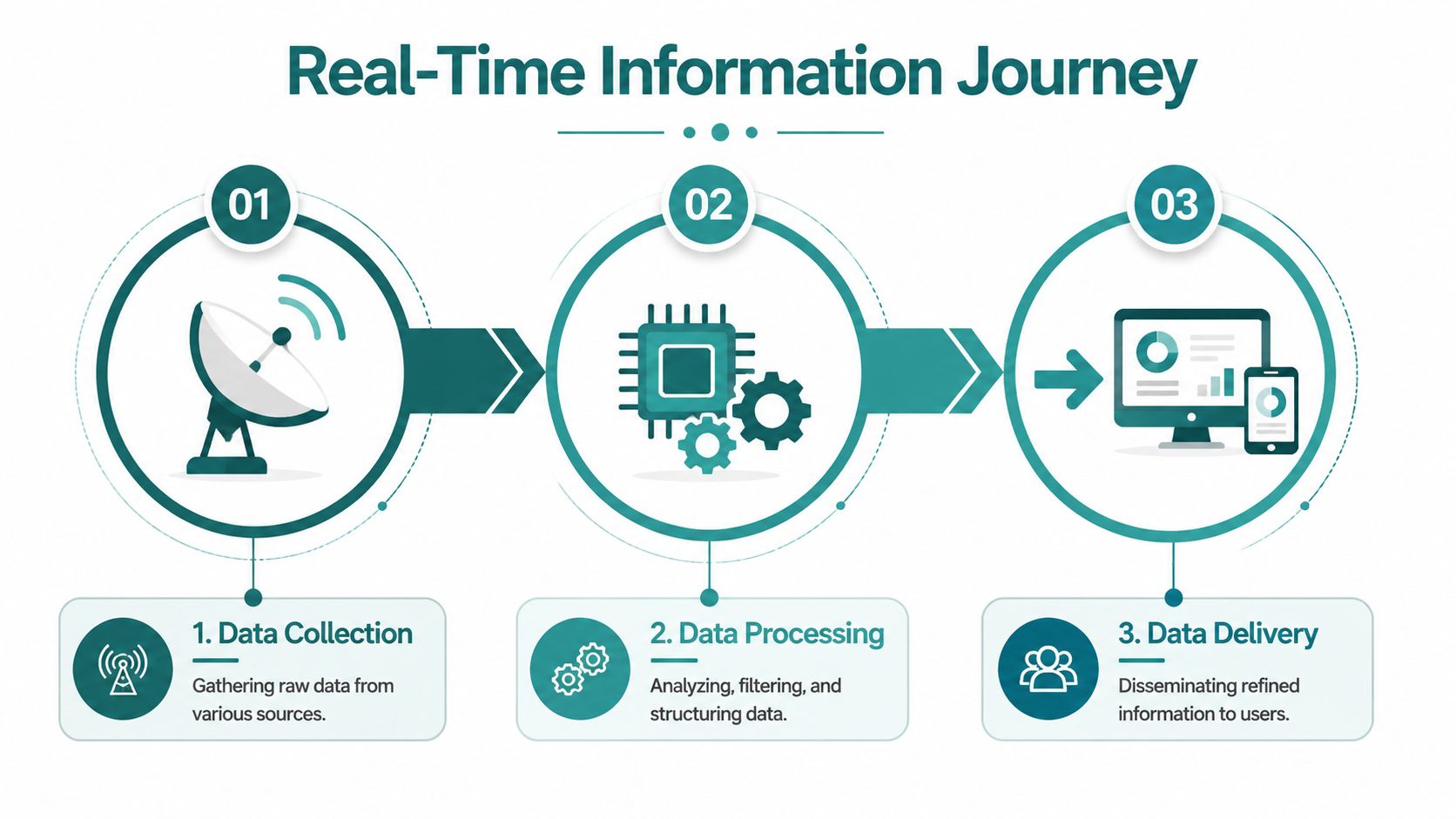
Data collection starts with live signals
In a transport or venue environment, the source might be vehicle location feeds, gate states, lift alarms, event schedules, occupancy signals, or smartphone motion sensors. The point isn't to collect everything. It's to collect the signals that affect user decisions.
Some of these sources are machine-generated. Others come from operational systems such as control rooms, maintenance tools, or customer information platforms. If the source isn't trustworthy, speed won't rescue it later.
Processing has one job
Processing should turn incoming events into something usable without adding avoidable delay. In practice, many teams use streaming patterns and message brokers such as Kafka to move data from source to application. The architecture matters because every extra transformation, queue, and dependency adds latency and points of failure.
For teams working on asset-heavy environments, there's a useful parallel in this practical guide to predictive maintenance ML. It shows the same operational truth. Data pipelines only create value when they feed decisions quickly enough to change outcomes.
A strong design keeps business rules close to the event stream, validates data early, and avoids unnecessary batch steps. For sensor-led navigation, that becomes even more important.
Delivery is where the user feels success or failure
The final stage is delivery through apps, APIs, screens, audio, or control interfaces. This is the point where latency stops being a technical metric and becomes a customer experience issue.
In the UK, real time information for accessibility use cases has a concrete threshold. The Department for Transport's 2024 guidance on real-time passenger information for public transit sets a benchmark of ≤2 seconds for critical accessibility applications that support blind and low-vision users relying on live audio navigation. That benchmark is part of what makes latency a business and compliance question, not just an engineering one.
Data that arrives late can still be accurate. It just isn't operationally useful.
What good delivery architecture tends to include
- A defined latency target tied to the use case, not a vague aspiration to be “live”
- Streaming ingestion rather than delayed, periodic updates where timing matters
- Direct routes to user channels so information isn't trapped in back-office systems
- Observability so teams can see when feeds are slow, stale, or broken
For navigation-specific environments, this sensor fusion algorithm approach shows why timely fusion of movement data and map context matters. If the data path lags, the instruction arrives after the person has already moved.
Why Static Timetables Are No Longer Enough for Modern Venues
Static information still has a role. Printed signs, fixed maps, and scheduled timetables provide baseline orientation. They don't handle live operations well.
The problem is straightforward. Public environments change constantly. Platforms alter, entrances close, queues build, escalators fail, and temporary works reshape the route that a visitor expected to take. A static sign can't reflect any of that.
Transport for London shows what modern expectations now look like. TfL reports that Tube, DLR, Elizabeth line and London Overground disruption and arrival information is updated live across its customer channels, and that its open data ecosystem publishes rail and bus status feeds used by third-party apps, as described in this explanation of real-time transport data in practice. The same source cites the Department for Transport's National Travel Survey finding that people in England made 922 trips per person per year in 2023. That scale explains why current information matters operationally.
Where static systems fail first
The first failure isn't usually technical. It's behavioural. People stop trusting the information channel.
Once users learn that signs, screens, or maps don't reflect current conditions, they fall back on staff, crowd behaviour, or guesswork. That increases pressure on front-line teams and creates inconsistency during disruption.
Why operators need dynamic information layers
A dynamic information layer helps operators respond without replacing physical infrastructure every time the environment changes.
Consider the contrast:
| Information type | Works well for | Fails when |
|---|---|---|
| Printed timetable | Planned, stable service patterns | Conditions change during the day |
| Static map | Basic orientation | Routes, entrances, or facilities become unavailable |
| Live service feed | Current service decisions | Data quality is poor |
| Dynamic wayfinding | Step-by-step routing in changing environments | Underlying map and event data aren't maintained |
This is why real time information has moved from enhancement to baseline expectation in transport, retail, healthcare, and large public venues.
What operations teams gain
- Less avoidable demand on staff because users can self-serve routine decisions
- Better crowd movement when people react to live conditions rather than stale signage
- More resilient customer communications across first-party and third-party channels
- A stronger accessibility position when journey information reflects real conditions
For operators considering navigation and passenger guidance, this public transportation directions perspective is relevant because it shifts the focus from static route display to live, situational guidance.
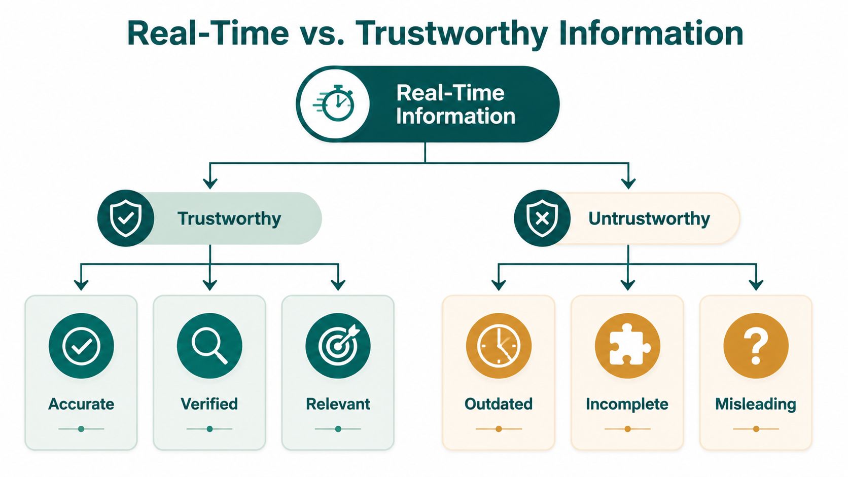
The Difference Between Real Time and Trustworthy Information
A lot of technology discussions stop too early. They ask whether information is delivered fast. They don't ask whether it is dependable enough to act on.
That distinction matters in stations, airports, campuses, hospitals, and shopping centres. A feed can update instantly and still be incomplete, wrong, or out of sync with physical reality.
Real time is a spectrum, not a magic label
Major vendors describe real time as a spectrum ranging from milliseconds to seconds or minutes, and they also note that near real-time access for analytics can sometimes take minutes or hours, as explained in this discussion of real-time data as a spectrum. That's a useful corrective because many buyer conversations still treat “real time” as if it has one universal meaning.
For an internal dashboard, a short delay may be acceptable. For spoken navigation in a complex interchange, it may not be.
Fast information that users can't trust creates a different kind of failure. It encourages action based on bad assumptions.
Trustworthiness has three parts
When operations teams evaluate real time information, they should separate three questions:
- Freshness. Is the information recent enough for the decision being made?
- Completeness. Does it include the changes that affect the route or service?
- Reliability. Can staff and passengers depend on it consistently?
A live feed that omits lift outages may be fresh but not complete. A feed that updates quickly but occasionally publishes the wrong platform may be fresh but unreliable. In both cases, the issue isn't speed. It's operational confidence.
Why public-facing systems expose the weakness
Internal systems can tolerate ambiguity because trained staff can cross-check information. Public-facing systems don't have that luxury. A passenger sees one message and acts on it. If the message is wrong, the organisation absorbs the cost through confusion, complaints, and manual intervention.
That's also why hardware-dependent approaches can become fragile over time. A technically elegant setup can still underperform if beacons drift, batteries fail, or installed infrastructure no longer matches the current layout. This look at Bluetooth access points and indoor navigation trade-offs illustrates why signal presence alone doesn't guarantee trustworthy guidance.
How Waymap Delivers Truly Dynamic Wayfinding
The practical challenge for operators isn't finding a system that can publish updates. It's finding one that stays usable in a messy, changing environment where hardware maintenance, accessibility duties, and operational budgets all collide.
A useful way to judge any real time information system is to ask whether its delivery model supports accessible, timely journey information that passengers can depend on. That distinction between real-time information and operationally trustworthy information is especially important in public-facing environments, as noted in this overview of real-time systems and trustworthiness in use.
Why infrastructure-free matters
Beacon-based and fixed-hardware systems often look manageable at procurement stage. The burden shows up later. Devices need to be installed, monitored, replaced, and kept aligned with the current estate. In a rail network, shopping centre, hospital, or campus, that becomes an operational maintenance programme.
Waymap uses dead reckoning with device-native sensors to support navigation indoors, outdoors, and underground, with sub-3-metre accuracy in infrastructure-free environments. It doesn't rely on GPS, Wi-Fi, or installed beacons to guide users through complex spaces. That matters when layouts change, staff turnover is high, or estates teams need updates without new physical works.
For transport and venue operators, the business effect is simple. Fewer physical dependencies usually mean fewer maintenance points and less risk that the digital guidance layer drifts away from the actual environment.
Compliance and operational fit
The Equality Act 2010 and related accessibility expectations create pressure to provide journey information that is not only available, but usable. In practice, a system that depends on patchy signal coverage or hard-to-maintain hardware can create compliance risk even if the original deployment looked sound.
An infrastructure-free model aligns better with environments where:
- Capital approvals are slow and hardware-heavy projects are hard to justify
- Layouts change often because of works, tenant changes, or temporary event operations
- Mixed user groups need route guidance that remains consistent across the estate
This overview of the underlying technology gives the technical background on how that approach works.
A short demonstration helps make the delivery model concrete.
Where this approach fits best
Named deployments matter because they show the technology meeting real constraints rather than ideal conditions. In environments such as WMATA and SBS Transit, the operational issue isn't only indoor positioning. It's whether people can be guided through large, changing, high-footfall spaces without creating another estate-wide hardware maintenance problem.
That's the core distinction. Dynamic wayfinding isn't just about publishing route instructions quickly. It's about keeping those instructions dependable when the venue changes faster than physical infrastructure can keep up.
Best Practices for Implementing a Real Time Information System
A good real time information project starts with restraint. Teams get into trouble when they try to make every data point live before they've decided which decisions need live support.
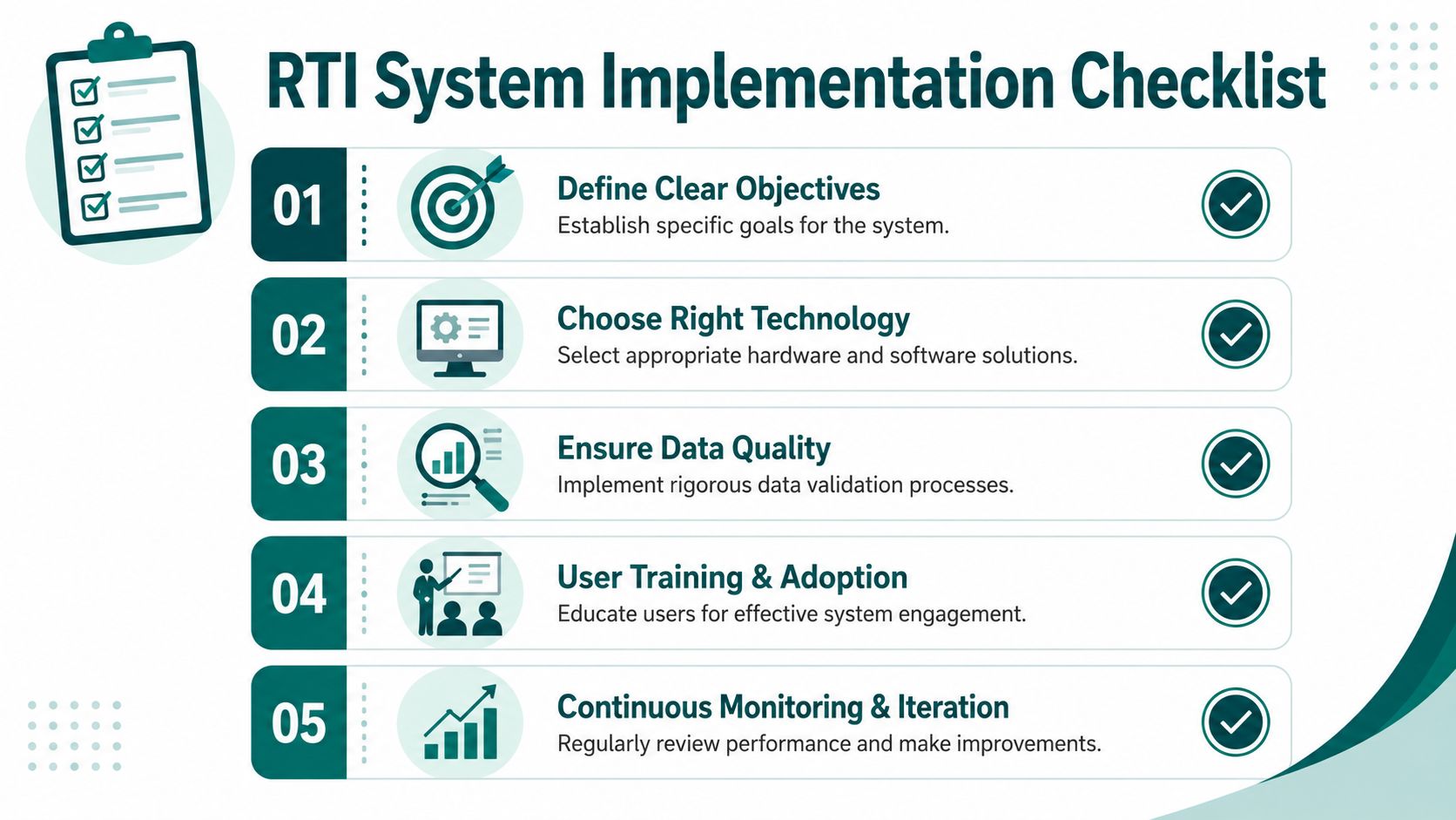
Start with the operational use case
Define the decision first. Is the system meant to support disruption alerts, platform guidance, indoor navigation, accessibility assistance, or control-room visibility? Different use cases justify different latency, governance, and maintenance models.
A useful checklist looks like this:
- Match latency to risk. A passenger information display and an audio navigation tool don't have the same tolerance for delay.
- Audit source quality early. Bad source data creates expensive confusion later.
- Design for operational ownership. Someone must maintain maps, points of interest, routing rules, and exception states.
- Plan for failure modes. Decide what the user sees when a feed is stale, partial, or unavailable.
- Avoid unnecessary hardware dependency. Every physical asset adds installation and maintenance overhead.
Build around maintainability
Many projects are approved on feature sets and fail on upkeep. If your system depends on specialist hardware, repeated recalibration, or manual reconciliation across disconnected feeds, operational costs will rise after launch.
Choose the architecture your team can maintain on its busiest day, not the one that looked impressive in a demo.
Common mistakes to avoid
A short list of recurring implementation errors:
- Buying “real time” as a label without defining acceptable latency for each journey type
- Treating data freshness as enough while neglecting accuracy and completeness
- Ignoring front-line workflow so staff don't trust or use the system
- Underestimating map and content governance in large, frequently changing estates
The organisations that get this right usually keep the scope narrow at first, prove reliability in one environment, and only then expand.
Frequently Asked Questions About Real Time Information
What is real time information in simple terms?
Real time information is information delivered quickly enough to be acted on immediately. In practice, that means the user can rely on it for a current decision, such as choosing a route, platform, or entrance.
What is the difference between real time and near real-time information?
Real time information is delivered with minimal delay for a use case that needs immediate action. Near real-time information is still current, but it may arrive later and suit monitoring or reporting better than instant decision-making.
Is live data the same as real time information?
Not always. Live data describes data that is currently being updated. Real time information is live data processed and delivered in a form people can use operationally.
Why does trustworthy information matter more than speed on its own?
Because users act on the message they receive. If information is fast but incomplete or wrong, it can create confusion faster than a slower but dependable system.
Where is real time information used outside transport?
It's used in hospitals, campuses, retail estates, airports, stadiums, and other large venues where conditions change during the day. For a practical adjacent example, Vendmoore Enterprises' smart vending solutions show how current operational data affects restocking and service decisions in another public-facing environment.
Does real time information always require installed hardware?
No. Some systems rely heavily on installed hardware, but others use software-led approaches, existing operational feeds, or smartphone sensors. The right choice depends on the environment, maintenance model, and accessibility requirement.
If you're reviewing how to make journey information more current, dependable, and accessible across complex spaces, Waymap is worth exploring. It provides precision navigation indoors, outdoors, and underground without GPS, Wi-Fi, or installed hardware, which makes it relevant for operators trying to improve wayfinding without adding another hardware estate to maintain.