
Public Transportation Directions: A Guide for 2026
Getting through a transport network should not require local knowledge, confidence with poor signage, or the willingness to ask staff for help at every interchange. Yet that is still how many journeys work in practice. A rider can plan the route perfectly on a phone, arrive at the right station, and then lose time at the exact moment precision matters most: the wrong entrance, the wrong subway passage, the wrong platform access point, or the wrong exit to the street.
That gap is why public transportation directions matter. For operators, this is not just a passenger-information feature. It affects missed connections, staff interruptions, accessibility compliance, and whether the system feels legible or hostile. In Great Britain, 16% of commuting trips were made by public transport in 2019, with a far higher share in London, according to the UK Department for Transport's National Travel Survey statistics. When that many work journeys depend on transit, directions at stops, stations, and interchanges become part of core operations.
From Waymap's perspective, the problem is straightforward. Legacy wayfinding was built around signs, maps, and assumptions about what a confident sighted traveller can infer. Modern public transport needs directions that work through the whole journey, including indoors, underground, and in the final stretch from stop to destination.
What Are Public Transportation Directions
Public transportation directions are the instructions that help someone complete a transit journey from origin to exact destination. That sounds obvious, but most systems still define directions too narrowly.
A route planner can tell you which bus to catch or which line to change onto. It often can't tell you which station entrance to use, how to cross a concourse, which side of an interchange leads to the correct platform, or how to continue from the stop to the right building entrance. Those details decide whether a journey feels simple or stressful.
They cover more than route planning
In practice, public transportation directions include several layers:
- Pre-journey planning that identifies the right service, departure, and interchange.
- On-site orientation through entrances, ticket halls, corridors, gates, stairs, lifts, and platforms.
- Transfer guidance when a rider moves between bus, rail, Underground, tram, or walking links.
- Arrival guidance for the final approach from the stop or station to the correct door.
That full-journey view is where many systems still fall short. Consumer apps are strong at network-level planning. Physical wayfinding is still doing too much of the work once the rider enters a station or loses GPS. The result is a handoff problem. The software gets people near the answer, then the environment takes over.
The physical environment still decides the experience
A large interchange exposes every weakness in a directions system. Signs compete for attention. Sightlines are blocked. Temporary works change circulation. Audio announcements are easy to miss. A rider who is unfamiliar with the station has to decode the place while under time pressure.
Practical rule: If directions stop at the station name, they are incomplete.
For disabled passengers, this matters even more. A route is only usable if each segment of the journey is navigable in the physical world, not just valid on paper. That is why digital wayfinding has to connect to pedestrian reality, not just transit timetables.
For a closer look at how this gap appears in live environments, our piece on the wayfinding app challenge in complex venues is useful background.
How Riders Get Directions Today
Most riders still use a patchwork of tools. Some are old, some are digital, and some work well only in part of the journey. None of this is accidental. Public transport wayfinding evolved in layers, and each layer solved a different problem.
London is the clearest benchmark. The London Underground opened in 1863 and the Tube carries more than 5 million passenger journeys on an average weekday in normal periods. A network with that scale and history depends on wayfinding across stations, passages, and interchanges. Directions in transit are not an optional add-on. They are part of making the system usable.
Static wayfinding still carries a lot of the load
Printed maps, line diagrams, station totems, overhead signs, and platform indicators remain fundamental. They are durable, familiar, and visible to large volumes of people at once.
They also have hard limits:
- They are fixed and can't adapt to a specific rider's destination.
- They assume visual interpretation and often assume English fluency.
- They struggle with complexity in large hubs where a few wrong turns have consequences.
- They age badly when layouts, entrances, or retail frontages change.
Static information is good at network legibility. It is weak at personal guidance.
Real-time station information helps, but only partly
Passenger information displays and audio announcements improve on static signs because they can reflect live running conditions. They can direct riders to platform changes, disruptions, or boarding information.
That still leaves a blind spot. Real-time information tells people what service is happening. It often doesn't tell them how to get physically from where they are standing to the correct place. That is a different task.
Consumer apps are strong outdoors and weaker indoors
Apps such as Google Maps and Citymapper changed expectations around journey planning. Riders now expect quick multimodal options, timetable integration, and walking instructions to and from stops. Fare planning tools also play a role. For travellers trying to reduce rail costs before they even set off, their rail fare splitting app can be a practical addition to the planning stage.
The weakness appears when blue-dot navigation becomes the main guidance model. GPS-based consumer mapping works well on streets. It becomes unreliable in stations, underground spaces, enclosed concourses, and multilevel interchanges. That is where many journeys become fragile.
Our article on the problem with blue-dot navigation indoors examines why that failure persists.
| Tool | What it does well | Where it breaks |
|---|---|---|
| Printed maps and signage | Gives network overview and broad orientation | Poor for exact, personalised guidance |
| Displays and announcements | Adds live service information | Doesn't solve physical navigation |
| Consumer journey apps | Good for route planning and outdoor walking | Loses precision indoors and underground |
A rider rarely experiences these tools as one system. They experience the handoffs between them.
Where Current Direction Systems Break Down
The biggest failures in public transportation directions are rarely at the planning stage. They happen in the last 50 metres of a journey, or at the transfer point where a rider must turn a route plan into a physical movement.
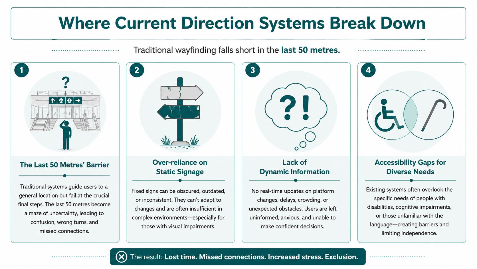
The route exists, but the rider still gets lost
A common failure pattern looks like this. The passenger reaches the correct station. The app says “arrived”. The station has multiple exits, multiple levels, and several lines. The destination is nearby, but not visible. The rider then wastes time choosing between passages, stairs, lifts, ticket halls, or street exits.
At this stage, many systems stop being useful. They are built to compute the trip, not to guide the person.
National guidance on pedestrian access to transit stresses that wayfinding, clear sightlines, and pedestrian routes need to support the trip from station or stop to nearby destinations. That matters in the UK because the Equality Act 2010 places a duty to avoid substantial disadvantage for disabled people, and the whole-journey concept is central to accessible travel.
Hardware and signage create operational drag
Legacy responses usually mean more physical infrastructure. More signs. More screens. More access points. More Bluetooth hardware. More layers of maintenance responsibility.
That creates familiar problems for operators:
- Temporary works break continuity because signs lag behind environmental changes.
- Hardware estates need upkeep across busy, harsh, high-footfall settings.
- Battery and device management becomes its own operational task.
- Fault diagnosis is slow when riders report navigation errors but the issue sits somewhere between map data, signage, and physical assets.
When agencies explore beacon-based systems, they often discover the upkeep is the actual cost. Our review of Bluetooth access points in complex venues goes into why that model can become difficult to sustain.
Accessibility still gets treated as a bolt-on
The most serious breakdown is ethical as much as operational. Many direction systems still assume that riders can read signs quickly, interpret maps visually, tolerate uncertainty, and recover from mistakes without much penalty.
That excludes or disadvantages people in different ways:
- Blind and low-vision passengers need continuous, precise guidance rather than landmarks they cannot verify visually.
- Wheelchair users need routes that reflect actual step-free continuity, not generic shortest paths.
- People with cognitive disabilities often need simpler, unambiguous instructions.
- Visitors and non-native English speakers can struggle with sign-heavy systems that rely on local knowledge.
Public transport is not fully accessible if the timetable is accessible but the station isn't navigable.
How Can Transit Agencies Modernise Wayfinding
A passenger enters a station they do not know, finds one lift out of service, meets a temporary barrier at the usual corridor, and loses the route at the point where the signs stop helping. That is the core modernisation test. The question is not whether an agency can add more wayfinding technology. It is whether the system still gives reliable directions when the environment changes and staff are already stretched.
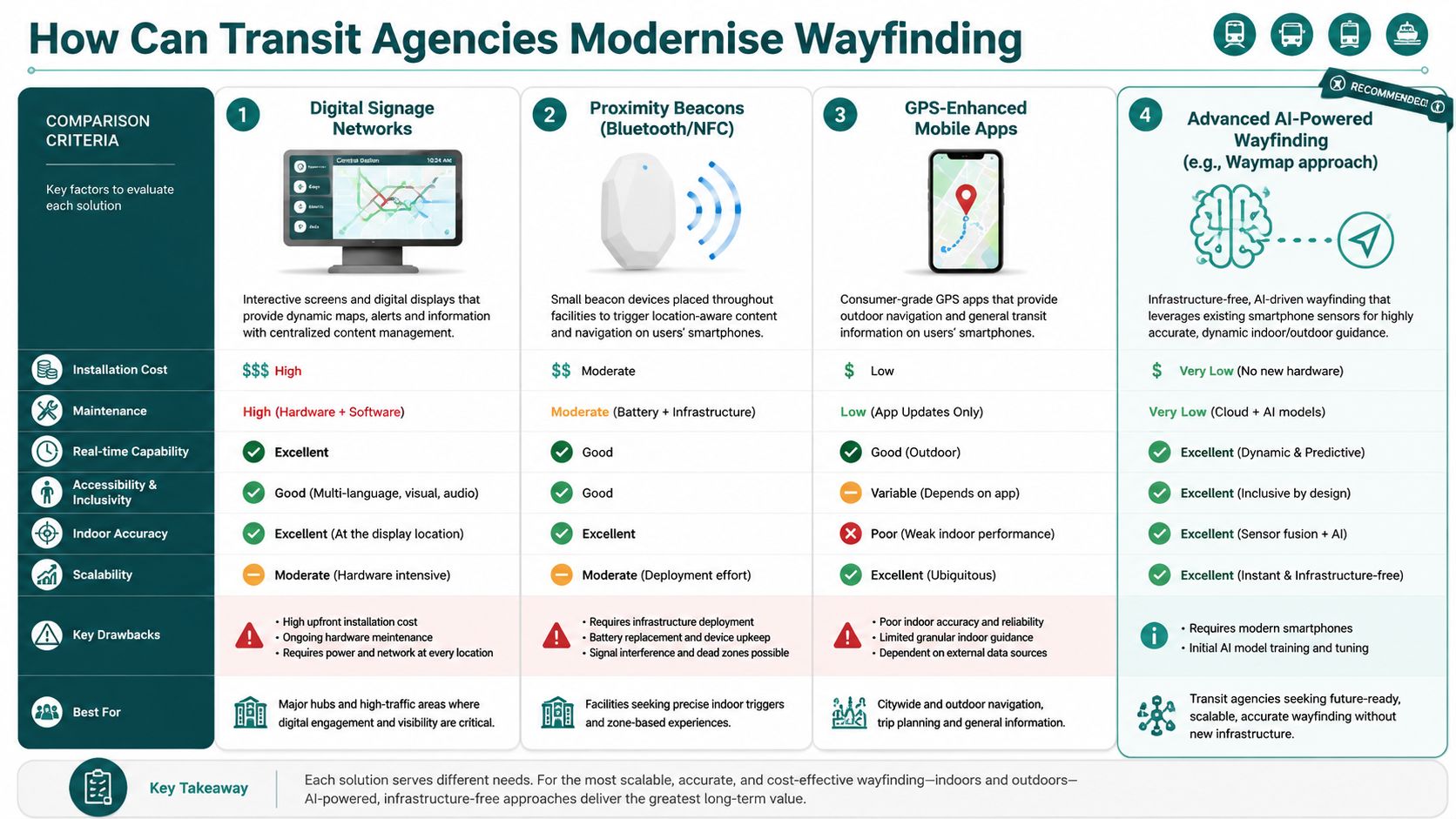
Transit agencies usually have three practical routes. The first improves the visible information layer. The second adds location hardware across the estate. The third shifts the problem into software, map management, and handset-based guidance. All three can play a role. Only one scales without creating a fresh maintenance burden.
Option one is improve the visible layer
Digital signs, interactive kiosks, and clearer passenger information displays can reduce confusion in busy interchanges. They are useful for disruption messages, platform changes, and general orientation. They also fit existing station operations, which is why many agencies start here.
Their limits show up quickly in accessibility work. Fixed displays do not move with the rider, cannot give turn-by-turn instructions, and still assume a person can locate the screen, read it, interpret it, and remember the route. They improve the station environment. They do not provide personal guidance through it.
Option two is deploy proximity hardware
Beacon, NFC, and Wi-Fi based systems can improve indoor positioning in controlled settings. On paper, that looks like a straightforward upgrade. In live transport operations, the business case is harder.
Every installed device becomes part of the asset estate. That means procurement, installation access, maintenance schedules, firmware checks, replacement stock, incident logging, and ownership when faults sit between digital and estates teams. Capital expenditure is only the entry cost. The long tail is operational.
This matters under accessibility duties. If guidance depends on hardware that is patchy, unmaintained, or offline in part of the station, compliance becomes fragile. Agencies that want a clearer view of the trade-offs should examine the benefits of infrastructure-free solutions for wayfinding reliability, scalability, and maintenance.
If you want a rider-focused explanation of first-mile and last-mile friction around transport access, the Punk Ride transportation guide is a useful companion read.
Option three is use infrastructure-free navigation
Infrastructure-free navigation changes the operating model. Instead of installing and servicing a second physical guidance network, agencies use smartphone sensors, well-structured map data, and a directions engine that works across the existing estate.
That approach is easier to maintain at network scale. Updates are made in maps and route logic rather than through repeated site visits to inspect, replace, or recommission equipment. It also aligns better with the Equality Act 2010 in practice, because accessible directions can be improved across many locations without waiting for another hardware rollout or capital funding round.
The trade-off is different, not absent. Agencies need accurate indoor mapping, disciplined change control, and testing that reflects how passengers move through entrances, gatelines, lifts, stairs, and platforms. But those are manageable data and operations problems. They do not add hundreds of new failure points in the field.
A simple comparison makes the decision clearer:
| Approach | Strength | Trade-off |
|---|---|---|
| GPS-based mobile apps | Familiar and useful outdoors | Weak indoors and underground |
| Beacon or Wi-Fi systems | Can improve indoor precision | Added hardware cost, upkeep, and failure points |
| Infrastructure-free sensor fusion | Scales without installed guidance hardware | Depends on high-quality map data and disciplined implementation |
A good procurement question is simple. Does the solution reduce operational burden over five years, or does it create another asset class to maintain while the accessibility gap remains only partly solved?
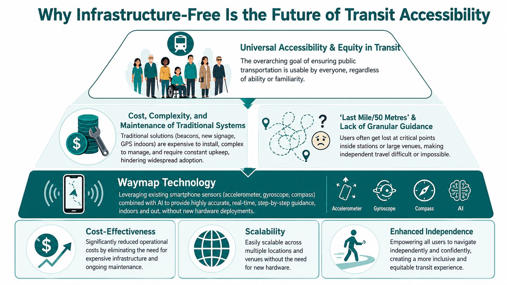
Why Infrastructure-Free Is the Future of Transit Accessibility
Infrastructure-free navigation is not just another technical option. For many transport operators, it is the only model that aligns accessibility goals with operational reality.
Transit navigation is a multimodal network problem
Public transport directions cannot be treated like simple road routing. ArcGIS's transit-analysis workflow states that public-transit travel requires a custom network dataset combining streets, stops, lines, and schedules because transit routing must account for timetable-based travel times and transfer constraints, as described in ArcGIS transit analysis guidance.
That matters because a modern directions engine has to do two things at once. It must understand the service network, and it must guide a person through the physical environment around that network. Most legacy systems are only good at one side.
Hardware-heavy compliance is fragile
The Equality Act 2010 creates duties around avoiding substantial disadvantage. In practice, operators need direction systems that can adapt as stations, entrances, obstacles, and pedestrian flows change. Static signs help, but they don't solve dynamic accessibility.
Hardware-heavy indoor navigation often fails here. The more physical components you install, the more points of failure you create. The more layouts change, the more you need reconfiguration. Accessibility should not depend on whether a battery, access point, or local device survey is current.
Software scales better than fixtures
One infrastructure-free option, Waymap, is particularly relevant. It uses dead reckoning from device-native motion sensors to provide step-accurate indoor, outdoor, and underground guidance without GPS, Wi-Fi, or installed beacons. That matters in transport because tunnels, concourses, and multilevel stations are exactly where signal-dependent systems struggle.
The commercial logic is as important as the technical one:
- CapEx pressure stays lower because there is no large hardware rollout across the estate
- Operational teams avoid a new maintenance class of batteries, tags, and receivers
- Updates can happen in software when paths, entrances, or points of interest change
- Accessibility can cover the whole journey rather than stopping at the station threshold
For a deeper operational view, our article on reliability, scalability, and maintenance in infrastructure-free wayfinding sets out the maintenance case in more detail.
When budgets are tight, the wrong wayfinding technology doesn't just cost money. It absorbs attention that operations teams need elsewhere.
Your Step-by-Step Implementation Guide
A workable wayfinding programme starts with diagnosis, not procurement. Agencies that skip this step usually end up digitising the same old weaknesses.
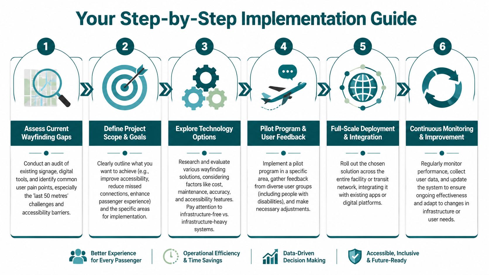
Start with an access audit, not a tech demo
Walk the journey as a passenger would. Test the main entrances, interchanges, step-free routes, bus-to-rail links, and final approaches to nearby destinations. Include temporary routes, not just ideal conditions.
Focus on where riders hesitate, backtrack, or need staff help.
- Map confusion points such as ticket halls, corridor splits, and exit choices.
- Check the final approach from stop or station to the destination entrance.
- Review accessibility barriers including missing curb continuity, unclear lift access, and poor auditory support.
High-quality catchment work also matters. ArcGIS's public-transit access tutorial recommends the “High Precision” setting for walking-time analysis, which is useful when building realistic walking service areas from networked pedestrian paths rather than simple buffers, as shown in the ArcGIS public transit access tutorial.
Define what success actually means
Different operators want different outcomes. Some need fewer missed connections. Some need better step-free clarity. Some are trying to reduce dependence on staff escorting passengers through large stations.
Write the brief in operational terms:
- Name the user groups. Daily commuters, occasional riders, blind users, wheelchair users, visitors.
- Choose the environments. Underground stations, bus interchanges, park-and-ride sites, campus connectors.
- Set maintenance expectations. If the team cannot support another hardware estate, rule those options out early.
For organisations assessing digital indoor guidance in wider estates, our guide to the internal navigation system approach is a practical next step.
Later in the process, show stakeholders the user experience clearly. This demonstration is helpful:
Pilot in the hardest place, not the easiest
Do not start in the simple station with clean sightlines and one platform island. Start where the current system struggles: a multilevel interchange, an underground concourse, or a busy multimodal hub.
A sensible pilot should include:
- Live user testing with disabled people and unfamiliar visitors
- Operational feedback from frontline staff
- Route-change procedures so you can see how quickly the system adapts
- Promotion planning because unused wayfinding is ineffective wayfinding
The point of the pilot is not to prove the concept in ideal conditions. It is to test whether the solution survives the practicalities of transport operations.
Frequently Asked Questions About Public Transportation Directions
What are public transportation directions?
Public transportation directions are instructions that guide a person through the full transit journey, including route planning, station navigation, transfers, exits, and the final walk to the destination. Good directions do more than name a bus or rail service. They help the rider move through the physical environment.
Why do public transportation directions often fail inside stations?
They often fail because many systems are designed for network planning, not indoor navigation. A journey planner can identify the correct line, but it may not guide the rider through entrances, corridors, gates, platforms, and exits with enough precision.
What is the biggest accessibility gap in transit wayfinding?
The biggest gap is usually the final part of the journey from stop or station to the exact entrance or platform. That is where sign-only systems, GPS-based tools, and fragmented information leave many riders without clear guidance.
Can public transportation directions work without GPS?
Yes. Public transportation directions can work without GPS when the system uses other methods to understand movement and location, especially indoors and underground where GPS is unreliable. That is the key requirement in stations, subways, tunnels, and enclosed interchanges.
Are beacon-based wayfinding systems the best option for transit agencies?
Not always. Beacon-based systems can support indoor navigation, but they also create installation and maintenance obligations that many agencies underestimate. A strong procurement process should compare hardware upkeep, access requirements, and update workflows against software-led alternatives.
How do modern direction systems help with Equality Act 2010 duties?
They help by supporting whole-journey accessibility rather than only timetable access. A modern system can reduce the risk that disabled passengers face avoidable barriers in stations, interchanges, and final walking routes, which is more aligned with the practical demands of accessible travel.
What should a transit agency assess before choosing a wayfinding solution?
It should assess where riders get lost, which user groups are most affected, how often layouts change, and whether the organisation can realistically maintain additional hardware. Total cost of ownership matters more than a clean pilot demo.
If you're reviewing how your organisation handles public transportation directions, Waymap is worth considering as part of that assessment. We build precision navigation for indoor, outdoor, and underground environments without relying on GPS, Wi-Fi, or installed hardware, with a focus on exact-door, platform, and interchange guidance that supports whole-journey accessibility.