
Position of Mobile Phone: A Practical Guide
You're standing in a station, the blue dot slips to the wrong platform side, and the phone insists you're somewhere you aren't. That problem isn't just “GPS being bad.” The position of a mobile phone is a live estimate built from satellites, radios, motion sensors, maps, and the way the handset is being carried. For estates teams, transport managers, and accessibility leads, that distinction matters because the fix changes depending on whether the phone is outdoors, in a concourse, underground, or tucked in a bag.
Why a Phone's Position Is Harder Than It Looks
A phone's location looks simple on a map, but the device is solving a layered problem every time it tries to place itself. Outdoors, it may lean on satellites. Indoors, it may rely on Wi-Fi, cellular signals, and its own motion sensors. In dense built environments, those inputs can disagree, so the device keeps revising its answer rather than producing one perfect pin.
The practical consequence is that the position of mobile phone is shaped by four things at once, signal availability, sensor quality, building geometry, and the user's carrying habits. A phone in an open square has a very different job from a phone in a ticket hall with steel, glass, and moving crowds. That is why the same handset can appear stable in one place and drift badly in another.
Practical rule: if the environment blocks or reflects signals, a phone's location becomes an estimate, not a certainty.
For readers who want the user-facing version of that problem, Waymap's explanation of the blue-dot experience is a useful starting point, especially where people notice location drift in real venues. The key point is not that phones are unreliable. It's that their position depends on what the device can still “see” at that moment.
How Satellites Fix a Phone's Position Outdoors
Outdoors, GNSS is the baseline. A modern handset normally uses more than one satellite system, and contemporary smartphone specs commonly list GPS, Galileo, GLONASS, BeiDou, and QZSS. That multi-constellation setup matters because more visible satellites improve geometry and reduce dilution of precision in dense UK street canyons and around transport hubs. The phone is not just counting satellites, it is solving for the best possible intersection of many weak signals.
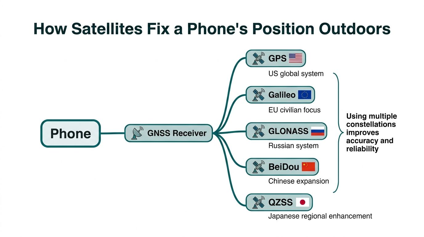
Why more satellites usually mean a steadier fix
If a handset can see satellites spread across the sky, its position solution is easier to stabilise. If the visible satellites are bunched together, the geometry is weaker and the estimate is less reliable. In UK cities, tall buildings and transport structures often leave the phone with a narrow view of the sky, so the device may have to work with fewer good signals and more reflected ones.
When satellite signals are blocked or bounced, the phone leans more heavily on its accelerometer and gyroscope to infer movement between fixes. That is why an outdoor route can remain usable for a while, then wobble as soon as the handset moves under an overpass, near a façade, or into a station entrance. For a plain-language explanation of why phones rely on location services at all, see Waymap's note on what location services do inside a handset.
A strong GNSS fix is usually an open-sky fix. Once the sky disappears, the handset has to guess more.
For navigation teams, the useful threshold is simple. GNSS alone works best when the user has a clear view of the sky. Once the environment becomes urban, enclosed, or reflective, the phone needs help from other systems.
Wi-Fi, Bluetooth and Cellular When Satellites Disappear
Indoor positioning is usually a compromise between coverage, accuracy, and maintenance. Wi-Fi, Bluetooth, and cellular each fill a different part of the gap left by GNSS, but each one depends on installed infrastructure or network conditions. That is why two buildings with the same floor plan can behave differently if their radio environments are not equally managed.
How the main indoor signals compare
| Signal | Typical accuracy | Requires installed hardware |
|---|---|---|
| Cellular | Roughly 10 to 50 metres | Yes, network infrastructure |
| Wi-Fi | Roughly 5 to 15 metres | Yes, access points |
| BLE beacons | Roughly 1 to 3 metres | Yes, beacons |
These bands are useful because they show the trade-off clearly. Cellular can support continuity, but it is broad. Wi-Fi is usually tighter, but it depends on access-point layout and signal stability. BLE can be more precise, but it requires deliberate installation and ongoing upkeep. For developers weighing Bluetooth-based options, this overview of Bluetooth connectivity solutions gives a useful technical backdrop.
Why UK coverage and venue design matter
Ofcom's Mobile Matter data shows UK 5G coverage is widespread but uneven by operator and geography, which means cellular support can't be treated as uniformly reliable across every site. That matters for systems that assume a mobile network will always be there to assist a fix. The better design is hybrid positioning, because the phone's radio stack already combines Wi-Fi, Bluetooth, LTE, 5G, and satellite systems on mainstream UK handsets.
For venue operators, that leads to a practical question. Do you want a positioning layer that depends on hardware installed across the estate, or one that can keep working when the radio environment changes? Waymap's note on indoor location tracking frames that choice well for complex buildings.
Inertial Sensors, Dead Reckoning and Map Matching
A phone can still estimate position after radio signals fade. Smartphones use the accelerometer, gyroscope, and magnetometer to track movement and direction, and the British Geological Survey explains how those sensors work together. In practice, that lets the handset carry forward a position estimate between stronger fixes by measuring how it has moved, turned, and accelerated. For a fuller technical background on those sensors, see inertial measurement units.
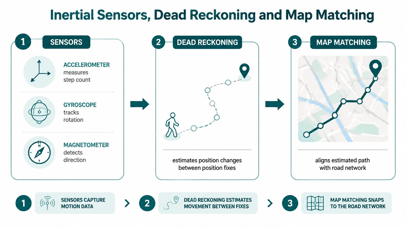
How dead reckoning fills the gaps
Dead reckoning starts from a known point and pushes that point forward using motion data. If someone walks down a corridor, the phone estimates distance and direction between location fixes. That works well in tunnels, underground concourses, and signal-dead malls, where radio signals are weak or absent. The estimate still drifts over time, but it often stays usable long enough to bridge the gap.
Map matching corrects that drift by snapping the inferred path to the digital layout. If the phone thinks the user is walking through a wall, the map constrains the route to the corridor, ramp, or platform edge instead. That is why navigation can keep working in places where pure GNSS fails.
Waymap uses that principle in a phone-first way. Its SmartStep system uses the motion sensors already inside a standard smartphone to track position without GPS, Wi-Fi, Bluetooth, or mobile signal, and its Visual Positioning System can identify a user's exact starting position from the camera. For teams that want a related sensor-led reference point while they build AR and measurement apps, the underlying engineering ideas are similar even if the product goal is different.
Useful mental model: radio signals tell you where the phone might be, inertial sensors tell you how it moved, and map matching tells you where that movement makes sense.
That combination matters for estates teams because it reduces dependence on local radio installations. It also matters for transit managers, where tunnels, escalators, and crowded concourses make pure signal-based positioning fragile.
Why Accuracy Numbers Mislead Operators
A vendor accuracy claim only means something if you know the environment behind it. Sub-3-metre accuracy in infrastructure-free environments is not the same promise as a radio system that depends on beacons, access points, or regular calibration. If your venue has changing layouts, large crowds, or limited capital for hardware, the deployment cost can matter more than the headline number.
The venue problem is operational, not theoretical
MCC Lord's Cricket Ground became the first stadium in the world to implement Waymap technology, which is relevant because stadiums combine hospitality areas, changing crowd flow, and accessibility needs. Transit operators like WMATA and SBS Transit face a different scale of problem, kilometre-long networks that mix underground, surface, and above-ground environments. Those conditions make maintenance burdens and coverage continuity central to the buying decision.
For NHS estates managers, the friction is different again. Beacon or access-point programmes can run into budget approval cycles and capital-spend constraints, especially when the layout changes or the site has multiple stakeholders. A system that needs no pre-mapping and no installed hardware is easier to justify in those conditions because it avoids a second project just to keep the first one alive.
How to read a positioning claim
Use this checklist before you compare vendors:
- Coverage context. Ask where the system works, outdoors, indoors, underground, or only in areas with installed hardware.
- Maintenance burden. Find out who updates the maps, hardware, and calibration after a move or refurbishment.
- Continuity. Check whether the system keeps working when the radio environment changes.
- Accessibility outcome. Verify whether it supports navigation to doors, platforms, and points of interest, not just a blue dot.
- Deployment fit. Match the technology to your estate, budget process, and staffing model.
The article on using Google Maps with React Native is useful if you're comparing app layers, but a venue decision still has to start with the environment. For an estates or transit manager, the right question is not “which number looks best?” It is “which system still works after the building changes?”
Privacy and Residual Tracking When Location Is "Off"
Turning off location services does not make a phone invisible. The EFF's mobile privacy guidance notes that phones can still be tracked through mobile towers, cell site simulators, Wi‑Fi, Bluetooth, and location leaks from apps and browsing. That matters because privacy risk is not only about explicit GPS permission, it's also about the residual signals the handset continues to emit.
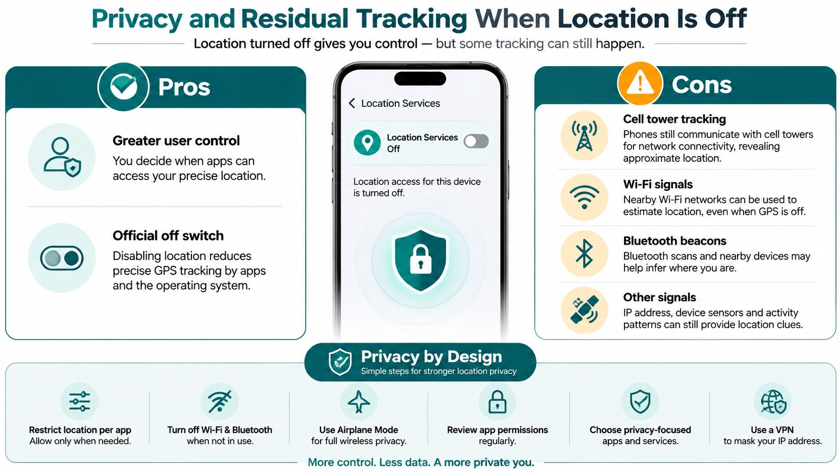
What the phone still reveals
Research on carrying habits shows that the position of mobile phone changes by person and context. In one survey, 60% of men reported carrying a phone in a pocket, 61% of women reported a bag position, 68% of participants said the phone was most commonly out on a table or desk across a 24-hour period, and 13% used a front trouser pocket. Those figures matter because a phone's orientation and placement affect what its motion sensors can infer.
The privacy point is subtle. Even when GPS is disabled, a handset in a pocket, hand, bag, or mount can still leak behavioural clues through orientation and movement patterns. In transport, workplace, and venue settings, that means the device may reveal more than people expect from a simple settings toggle.
Waymap's consent-management note is useful here, because it treats privacy as a design problem rather than a switch buried in settings, especially when location, sensor use, and user consent need to be aligned. A privacy-respecting navigation system tries to reduce unnecessary sensor and radio surface area.
If a system needs less data to do the job, it usually creates less privacy risk.
For operators, that is the operational takeaway. A good positioning design limits what it collects, what it stores, and what it needs from the user.
Choosing a Positioning Approach for Your Venue
The legal and standards backdrop is clear. The Equality Act 2010, BS 8300, PAS 78, and the UN Convention on the Rights of Persons with Disabilities all push venues toward usable navigation, not merely compliant signage. That creates demand for infrastructure-free options when hardware rollouts are slow, maintenance budgets are tight, or the building changes often.
Match the technology to the friction
For NHS estates, the pressure point is capital approval and ongoing upkeep. For transit operators, it is the burden of maintaining physical hardware across high-footfall environments. For retail and venue teams, the case has to include accessibility, dwell, and visitor experience, not compliance alone.
Waymap's named deployments at MCC Lord's, WMATA, and SBS Transit show how the same underlying positioning idea can be applied in different operational settings. The common thread is that the guidance has to survive changing layouts and difficult signal conditions.
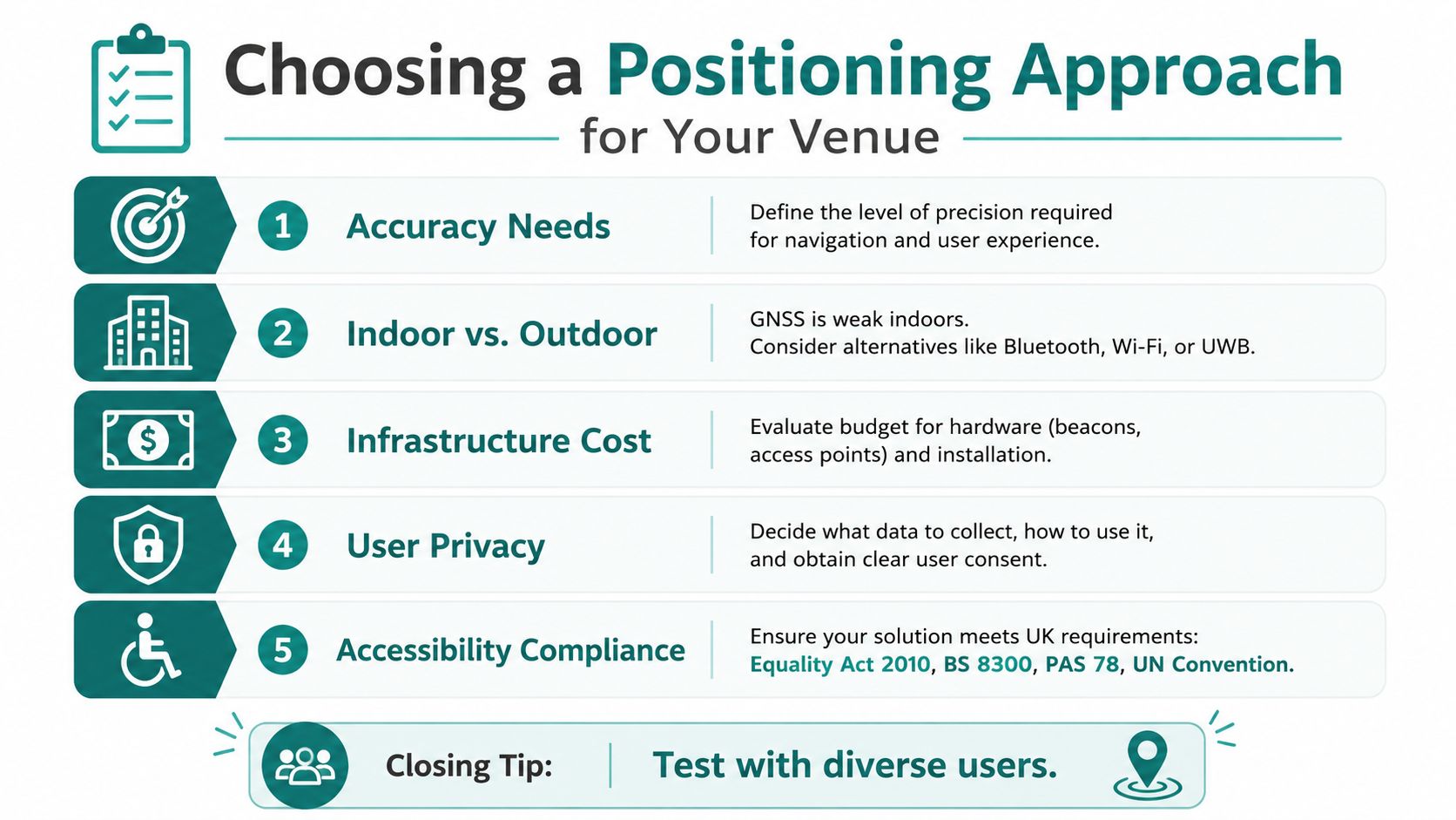
If you are comparing solutions, use five questions. Does it work in your hardest spaces, not just your easiest ones? Does it need installed hardware? Does it support accessibility outcomes that matter to real users? Does it respect privacy by design? And can your team keep it running without turning every refurbishment into a new project?
Test with diverse users before you sign off. A system that passes in a demo room can still fail in a concourse, a basement, or a crowded event day.
Frequently Asked Questions on Mobile Phone Position
What determines the position of a mobile phone? The position of a mobile phone is determined by satellites, Wi‑Fi, cellular networks, and the phone's own motion sensors. In practice, the device fuses those inputs and then adjusts for building geometry, signal loss, and how the phone is being carried.
Why does GPS misplace me indoors? GPS misplaces you indoors because satellite signals weaken or disappear without a clear line of sight to the sky. The phone then relies more heavily on sensor fusion, map matching, Wi‑Fi, or cellular data to keep the estimate alive.
Can a phone still be tracked when location services are off? Yes, a phone can still be tracked when location services are off. Cellular networks, Wi‑Fi, Bluetooth, and sensor data can still reveal approximate location or movement patterns.
Do venue operators need installed beacon hardware to meet UK accessibility obligations? No, they don't always need installed beacon hardware to meet UK accessibility obligations. The right approach depends on the venue, but the Equality Act 2010, BS 8300, PAS 78, and the UN Convention all support usable navigation outcomes, not a single required hardware model.
If you're planning navigation for a station, campus, stadium, or hospital, Waymap can help you design for the way phones position themselves, outdoors, indoors, and underground. Visit Waymap to see how sensor-based guidance can fit your venue, your accessibility goals, and your maintenance constraints.
