
Indoor Location Tracking: 2026 Guide to BLE & UWB Tech
By Tom Pey, Founder at Waymap and blind accessibility technologist.
A visitor arrives at a rail station, hospital or shopping centre with plenty of time. Ten minutes later, they're still circling the same concourse, reading inconsistent signs, asking staff for help, and watching the clock. For the venue operator, that isn't a minor irritation. It creates pressure on front-line teams, damages confidence in the venue, and turns a navigation problem into an operational one.
That's why indoor location tracking has moved from nice-to-have to core infrastructure. It gives operators a live digital layer for orientation inside places where GPS falls short. In practice, that means fewer wayfinding bottlenecks, less dependence on static signage, and a route to accessibility that doesn't rely on a person spotting the right sign at the right moment.
Why Is Accurate Indoor Location Tracking Now a Necessity
The familiar failure point in large venues isn't lack of information. It's mismatch. The sign is technically present, but it's too far away, too high, out of date, blocked by a crowd, or written for someone who already understands the building. Airports, hospitals, interchanges, campuses and retail centres all have the same pattern. People don't just need information. They need orientation in motion.
For operations teams, that creates a daily drag. Staff are pulled into repeat directions. Visitors arrive late and stressed. Complaints often describe the same issue in different language: confusing layout, hard to find, poor accessibility, difficult to transfer, unclear entrances.
Static wayfinding no longer keeps up
Static signs still matter, but they can't respond to day-to-day reality. A lift goes out of service. A platform changes. A department moves. A temporary barrier appears. The building changes faster than physical wayfinding can.
That's one reason adoption is accelerating. The UK indoor location tracking and positioning market was valued at approximately $7.83 billion in 2026 and is projected to reach $18.92 billion by 2035 according to Business Research Insights on the UK indoor location tracking and positioning market. Decision-makers across retail, healthcare, logistics and production are responding to the same fact: enclosed environments need their own positioning layer.
Indoor navigation stops being a digital add-on when your venue is large enough for people to get lost in a way that affects service delivery.
The business case is wider than navigation
Indoor location tracking supports more than turn-by-turn guidance. It shapes visitor experience, staffing demand, accessibility delivery and digital service design. In retail, it also connects directly to movement, dwell and conversion questions that physical venues already care about. That's why work on navigation often sits beside broader discussions about footfall in retail environments.
The strategic shift is simple. Venue managers used to ask whether digital wayfinding was worth adding. Now the sharper question is whether relying on signs alone is still defensible.
How Do the Core Indoor Location Technologies Work
Indoor location systems all answer the same question: where is this person or asset inside a building? They answer it in different ways, and the trade-offs matter more than the label on the spec sheet.
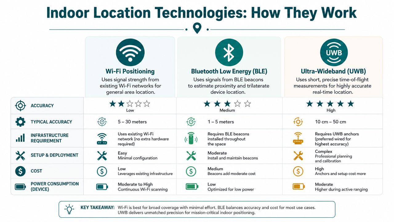
A useful way to think about the main options is this. BLE is like a set of lighthouses. Wi-Fi positioning is closer to measuring signal relationships across an existing network. UWB behaves more like a precision ranging tool built for exact spatial measurement.
How Wi-Fi, BLE and UWB differ in practice
Wi-Fi positioning uses signals from access points to estimate location. Its appeal is obvious. Many venues already have Wi-Fi installed. The limitation is just as obvious once you try to use it for navigation. Networks are deployed for connectivity, not necessarily for positioning consistency in corridors, vertical circulation areas or complex public spaces.
Bluetooth Low Energy, or BLE, usually relies on beacons placed around the building. A phone detects nearby beacon signals, and the system estimates position from those relationships. When BLE is combined with smartphone inertial sensors, it becomes far more useful for practical indoor navigation because the phone can interpret movement between signal reads.
Ultra-Wideband, or UWB, is the precision option. It's designed for environments where the exact location of equipment, vehicles or people matters at a much finer level. That makes sense in industrial automation and some specialist tracking scenarios. It also means more infrastructure, more planning and less tolerance for uneven deployment.
For readers who want a broader grounding in positioning logic, our overview of how a navigation system works indoors and outdoors covers the fundamentals.
A short explainer helps make the differences easier to see:
What operators need to ask before choosing
The right question isn't “which technology is most advanced?”. It's “which one fits our building, our use case, and our operating model?”
| Indoor Location Technology Comparison | |||
|---|---|---|---|
| Technology | How It Works | Infrastructure Required | Typical Accuracy |
| Wi-Fi positioning | Estimates position from Wi-Fi signal relationships | Existing or enhanced Wi-Fi network | General indoor positioning suitable for broad area guidance |
| BLE | Uses beacon signals, often combined with phone motion data | Beacons installed through the venue | For most navigation applications, 2–3 metre accuracy can be sufficient when BLE is combined with smartphone inertial sensors, as noted by Crowd Connected's indoor positioning guide |
| UWB | Measures precise ranging between devices and anchors | Dedicated UWB infrastructure | High-precision location, often used where centimetre-level performance is needed |
The infrastructure-free model is different
There's another category that matters for real deployments. Instead of relying on installed hardware, some systems use dead reckoning with device-native sensors. That means the phone interprets movement from its own sensors against a detailed map, rather than depending on beacons or venue hardware for every location update.
Practical rule: If your building changes often, your location system should be easy to update in software, not dependent on engineers revisiting hardware on site.
That distinction becomes important once procurement moves beyond pilot mode. Hardware can work well. Hardware also creates an estate to maintain.
What Level of Accuracy Can You Realistically Expect
Accuracy is the first number most buyers ask for, and often the wrong starting point. The key question is accuracy for what.
If you're guiding a visitor through a shopping centre, station or hospital, you need dependable route guidance that stays coherent as they move. If you're coordinating robotics or tracking equipment in a constrained industrial process, you need much finer positional certainty.
Match the precision to the job
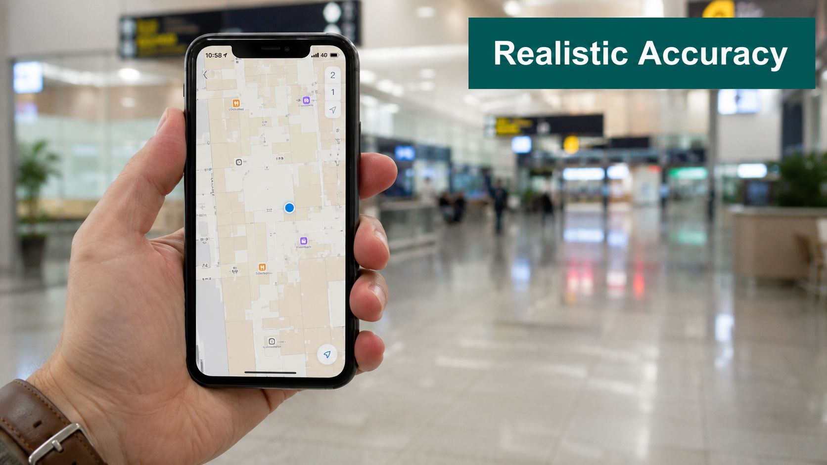
According to Wikipedia's overview of indoor positioning systems, indoor positioning systems can achieve a position accuracy of 2 centimetres, while standard Wi-Fi and Bluetooth-based systems typically offer accuracy between 1 and 5 metres. The same source notes that for most navigation applications, 2–3 metre accuracy achieved by combining BLE with smartphone inertial sensors is more than sufficient.
That spread tells you something important. “More accurate” isn't automatically “better” if the application doesn't need it and the cost of getting there is much higher.
A sensible way to frame it is:
- Visitor navigation and wayfinding: Consistent positioning in the right part of the route matters more than laboratory-grade precision.
- Asset tracking in complex operations: You may need tighter location boundaries and faster confidence in exact placement.
- Industrial automation and robotics: Centimetre-level performance starts to become operationally necessary.
If you're assessing whether a high-precision system is justified, it helps to separate positioning from guidance. Our explainer on what UWB is used for in location systems is useful here.
Path reliability matters more than a single dot
A venue operator can be misled by map-dot thinking. A static point on a screen may look precise, but that doesn't guarantee the user gets reliable step-by-step directions through real-world obstacles, turns and vertical transitions.
A dependable route is often more valuable than a highly precise momentary coordinate.
For blind and low-vision travellers especially, the practical test isn't whether the dot appears exact. It's whether the guidance remains trustworthy from entrance to destination. That's why step logic, heading stability and turn timing matter so much in deployed navigation systems.
What Are the True Costs of Deployment and Maintenance
Most procurement conversations start with purchase price. The harder part starts later, when finance and operations teams realise they've bought not just a system, but an ongoing maintenance obligation.
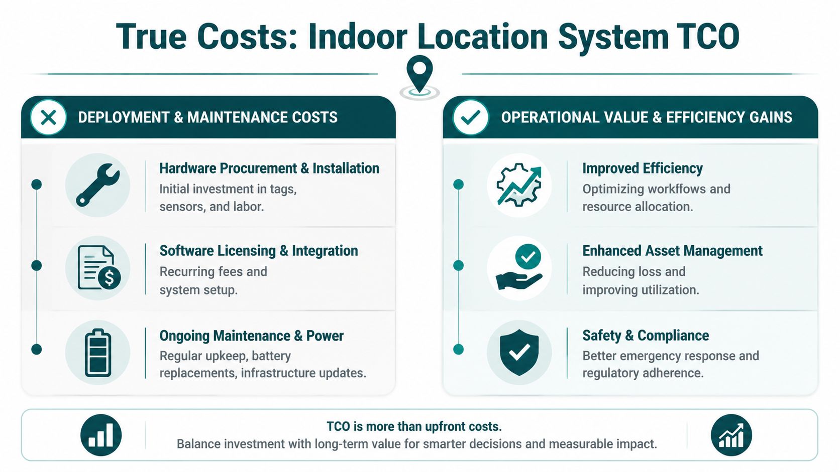
Hardware-based indoor location tracking creates a physical estate. Beacons need installing. Anchors need power and placement checks. Batteries need replacing. Site changes need recalibration. In busy public venues, hardware also gets moved, blocked, forgotten or damaged.
The hidden line items appear after launch
The cost categories usually look like this:
- Initial deployment: surveys, design, installation labour, integration work and testing.
- Operational upkeep: battery cycles, replacement hardware, software management, support visits and troubleshooting.
- Change management: map updates, moved points of interest, temporary closures and altered routes.
- Internal burden: the staff time needed to own the system across estates, IT, digital and front-line operations.
The most common mistake is treating these as edge cases. They're not. They define total cost of ownership.
High-change venues punish hardware-heavy models
Hospitals are a good example. Estates teams already manage a long list of competing priorities, and budget approval often distinguishes between capital spend and recurring operational spend. A hardware-dependent location system can look acceptable at pilot stage and awkward in year two, when the costs shift from installation to ongoing maintenance and support.
Transit operators face a similar issue, but with higher footfall, more physical complexity and greater consequences when information is out of date. Maintaining hardware across interchanges, platforms, sub-surface spaces and public circulation areas is not a trivial service task.
Buyers should ask a simple question early: who owns the maintenance burden after the ribbon-cutting moment has passed?
There's also a technology fit question. The global indoor location market is projected to grow from USD 18.35 billion in 2026 to USD 50.10 billion by 2031 at a CAGR of 22.3%, according to MarketsandMarkets research on the indoor location market. Growth doesn't remove the deployment problem. It increases pressure to choose systems that scale operationally, not just technically.
Why infrastructure-light approaches change the economics
An infrastructure-free approach removes a large part of that burden. If the system works from the smartphone and the map, updates happen digitally. There's no beacon battery programme to manage and no anchor network to maintain across the venue.
That doesn't mean no work at all. Mapping, testing, governance and support still matter. It means the recurring operational drag is much lower, and cost becomes easier to predict.
For teams weighing BLE estates against lighter models, our notes on Bluetooth access points and their operational implications are relevant.
How Does Indoor Navigation Support Accessibility and Compliance
Accessibility in navigation isn't solved by adding more signs. It's solved when a person can move through a building independently, safely and with dignity. That's a different standard.
For UK venues, the regulatory context matters. The Equality Act 2010 places duties around reasonable adjustments. Built environment standards such as BS 8300 also shape expectations around inclusive design. For public-facing operators, accessibility isn't a side programme. It sits inside service delivery, estate planning and reputational risk.
Why traditional aids have limits
Physical signage, tactile surfaces and staffed information points all have a role. None of them gives dynamic, personalised, turn-by-turn guidance through a changing indoor environment.
That gap becomes obvious in hospitals, stations and large retail environments. A sign can indicate a department. It can't adapt in real time when a lift is unavailable, a route is closed, or a traveller needs guidance to a specific entrance rather than a general zone.
For blind and low-vision users, that difference is decisive. Dr Tom Pey built Waymap from lived experience as a blind traveller who understood that independence depends on more than nominal access. It depends on reliable instruction at the point of movement. Where organisations need user support around digital accessibility and deployment, practical planning matters as much as policy, which is why end-user support in accessible navigation rollouts shouldn't be treated as an afterthought.
Compliance is about outcomes, not box-ticking
An accessible navigation service should help an organisation answer difficult questions clearly:
- Can a visitor travel independently from entrance to destination?
- Can route information adapt when the building changes?
- Can the service work for people who don't rely on visual cues?
- Can updates be made without replacing physical infrastructure across the site?
Those are operational questions, but they're also compliance questions.
Meeting accessibility duties is easier when navigation can be updated in software, delivered in audio, and designed with disabled users from the outset.
That's why software-led indoor navigation is becoming more important in accessibility programmes. It is not a replacement for inclusive physical design. It is the dynamic layer that physical design alone cannot provide.
An Evaluation Checklist for Your Indoor Location Solution
When buyers compare indoor location tracking vendors, the polished demo usually hides the expensive part. The right procurement process exposes what happens after deployment, in awkward spaces, under operational pressure, with real users.
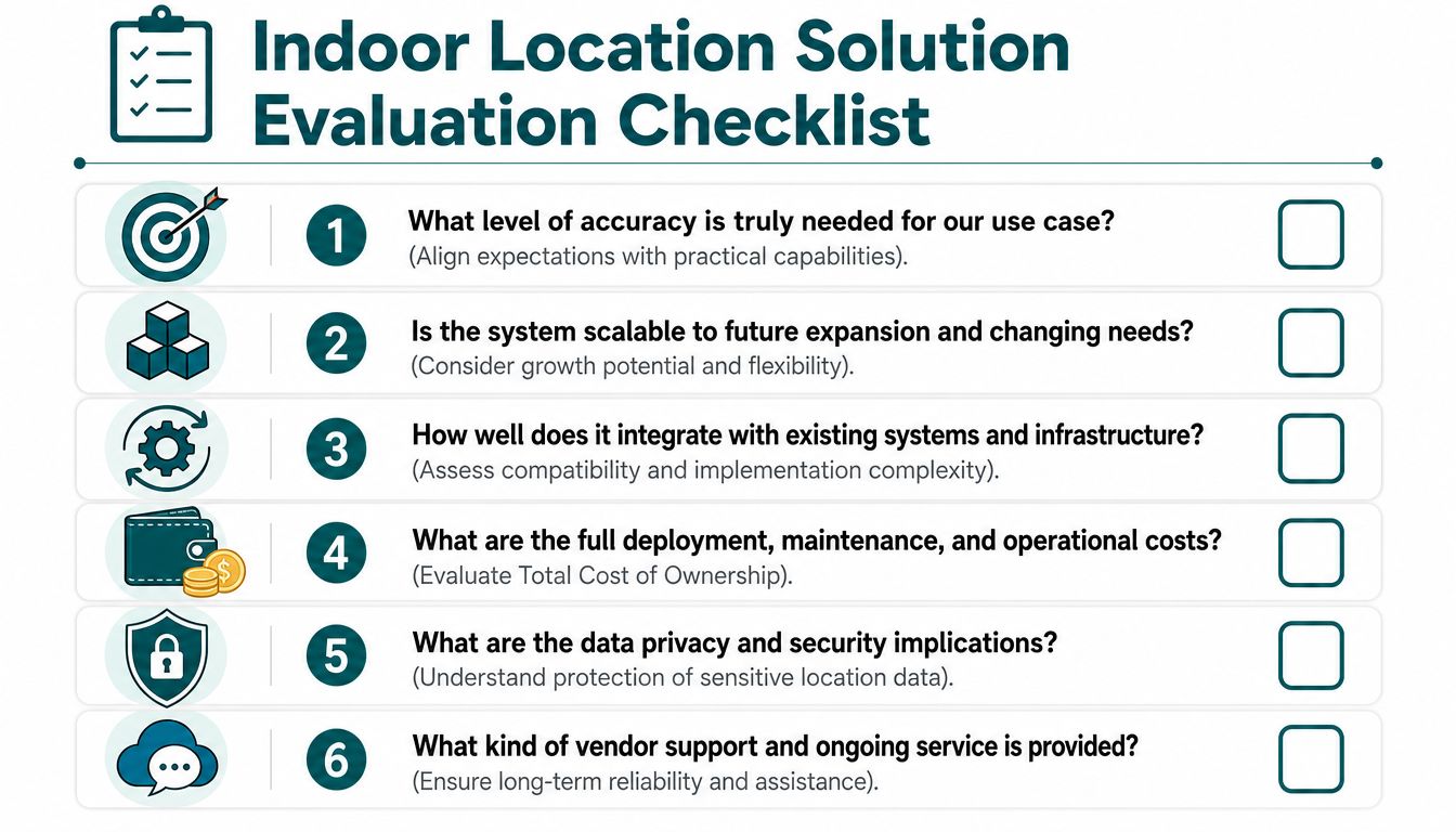
Ask these questions before you shortlist anyone
What level of accuracy do we actually need?
A shopping centre, airport terminal and industrial plant don't need the same thing. Ask the supplier to map claimed accuracy to your use case, not just quote a best-case technical figure.What infrastructure must be installed, powered and maintained?
This reveals whether you are buying software, hardware, or both. It also reveals who will own the maintenance estate when layouts change and components fail.How does the system perform in signal-poor or awkward areas?
Stairwells, underground corridors, service passages and dense public spaces tend to expose weaknesses very quickly.
Look beyond the launch phase
How quickly can route changes and points of interest be updated?
If a venue change requires physical intervention across the building, updates will lag behind reality.What are the exact ongoing maintenance requirements?
Ask for a plain-language breakdown. Batteries, recalibration, hardware replacement, software support and map maintenance should all be explicit.Was the product designed with disabled users, or only adapted later?
Accessibility-first systems ask different design questions from the start. That affects route logic, instruction style, user interface choices and testing methods.
Don't ignore governance and integration
A strong evaluation also includes:
- Data handling: What location data is collected, retained and exposed to operators?
- Integration path: Does it fit your app strategy, your digital estate and your support model?
- Vendor realism: Can the supplier explain trade-offs clearly, or do they claim every advantage at once?
A credible vendor should be comfortable discussing limits. If every answer sounds effortless, the due diligence hasn't started yet.
Putting It All Together The Waymap Approach
The central choice in indoor location tracking isn't only about accuracy. It's about operating model. Do you want to maintain a hardware estate across a live venue, or do you want a navigation layer that depends primarily on the device people already carry?
That's where the infrastructure-free approach stands apart. Waymap uses dead reckoning from smartphone-native motion sensors, matched to detailed maps, to deliver step-accurate guidance without relying on GPS, Wi-Fi or installed beacons. In practical terms, that changes three persistent problems at once: maintenance burden, update speed and accessibility delivery.
Why this model fits modern venues
For transport operators, the appeal is straightforward. Public environments change constantly, and maintaining hardware across complex stations is costly and operationally awkward. For hospitals and campuses, digital updates are easier to govern than physical changes to a beacon estate. For retail and mixed-use venues, the same model supports wayfinding without creating another network to service.
Named deployments matter because they show fit under real constraints. Waymap has been deployed in environments including WMATA and Westfield London, where navigation needs to work in complex, high-footfall spaces rather than ideal test conditions.
The practical takeaway for decision-makers
If your priority is industrial-grade ranging inside a controlled zone, hardware-heavy systems may still be justified. If your priority is scalable public navigation, accessibility and lower long-term maintenance, infrastructure-free indoor navigation deserves serious consideration.
The wider point is not that one technology wins every scenario. It's that many venues have been sold precision they don't need, alongside maintenance they didn't fully price in. Decision-makers usually get better outcomes when they start with the user journey, the compliance duty and the operating burden, then choose the technology that fits.
Frequently Asked Questions About Indoor Location Tracking
What is indoor location tracking
Indoor location tracking is the process of determining where people or assets are inside buildings where GPS is unreliable or unavailable. It supports use cases such as navigation, routing, asset visibility and operational oversight in places like stations, hospitals, campuses and shopping centres.
What's the difference between indoor positioning and indoor navigation
Indoor positioning tells you where something is. Indoor navigation tells you how to get somewhere. Positioning is the location estimate. Navigation adds route logic, instructions, turns and destination guidance.
Is the most accurate system always the best choice
No. The best system is the one that fits the use case and operating model. Centimetre-level precision may be essential for robotics or specialist industrial tracking, but public wayfinding usually depends more on route reliability, accessibility and maintainability.
Does indoor location tracking require beacons or installed hardware
Not always. Some systems depend on beacons, anchors or Wi-Fi infrastructure, while others use smartphone sensors and digital maps. That distinction matters because it affects deployment speed, maintenance burden and how easily a venue can keep the system up to date.
How does indoor location tracking support accessibility
It supports accessibility by giving people direct, route-based guidance through spaces that are often difficult to interpret from signage alone. For blind and low-vision users especially, audio-led navigation can provide a more independent experience than static wayfinding.
What should buyers ask vendors first
Start with the full operating burden, not the headline demo. Ask what infrastructure is required, how updates are made, how awkward spaces are handled, what maintenance is ongoing, and whether disabled users were involved in product design and testing.
How is privacy usually handled in indoor location systems
Privacy should be handled through clear data governance, minimal collection, appropriate consent where needed, and careful control over what is stored or shared. Buyers should ask for a plain explanation of the data model before procurement proceeds.
Can indoor location tracking be added to an existing app
Yes, many indoor location services can be integrated into an existing mobile app through an SDK or related integration approach. Key questions are how much technical work is required, what data flows are involved, and who supports the deployment after launch.
If you're reviewing options for accessible, infrastructure-light indoor navigation, Waymap shows how smartphone-native positioning can support complex venues without the maintenance burden of installed hardware.
