
Offline Navigation App Explained How It Works Offline
You leave a station platform, follow signs through a concourse, and reach a lift. Then your phone loses its signal. The map stops updating just as the route becomes most difficult, perhaps at a basement entrance, a hospital corridor, or an underground interchange. For a person who is blind or has low vision, that interruption can turn a familiar journey into a series of uncertain decisions.
An offline navigation app is designed for this transition. It keeps positioning and route guidance available when a journey moves between an outdoor street, an indoor building and an underground space. The important question isn't whether a map can be downloaded. It's whether guidance remains usable at the exact door, platform, lift or service point the traveller needs.
What an Offline Navigation App Actually Does
A standard GPS app is useful in open air, where satellite signals and mobile data can support positioning and route updates. That model becomes fragile inside a hospital, shopping centre or railway station. Thick walls, underground levels and crowded networks can interrupt the connection, leaving the user with a static blue dot or no useful position at all.
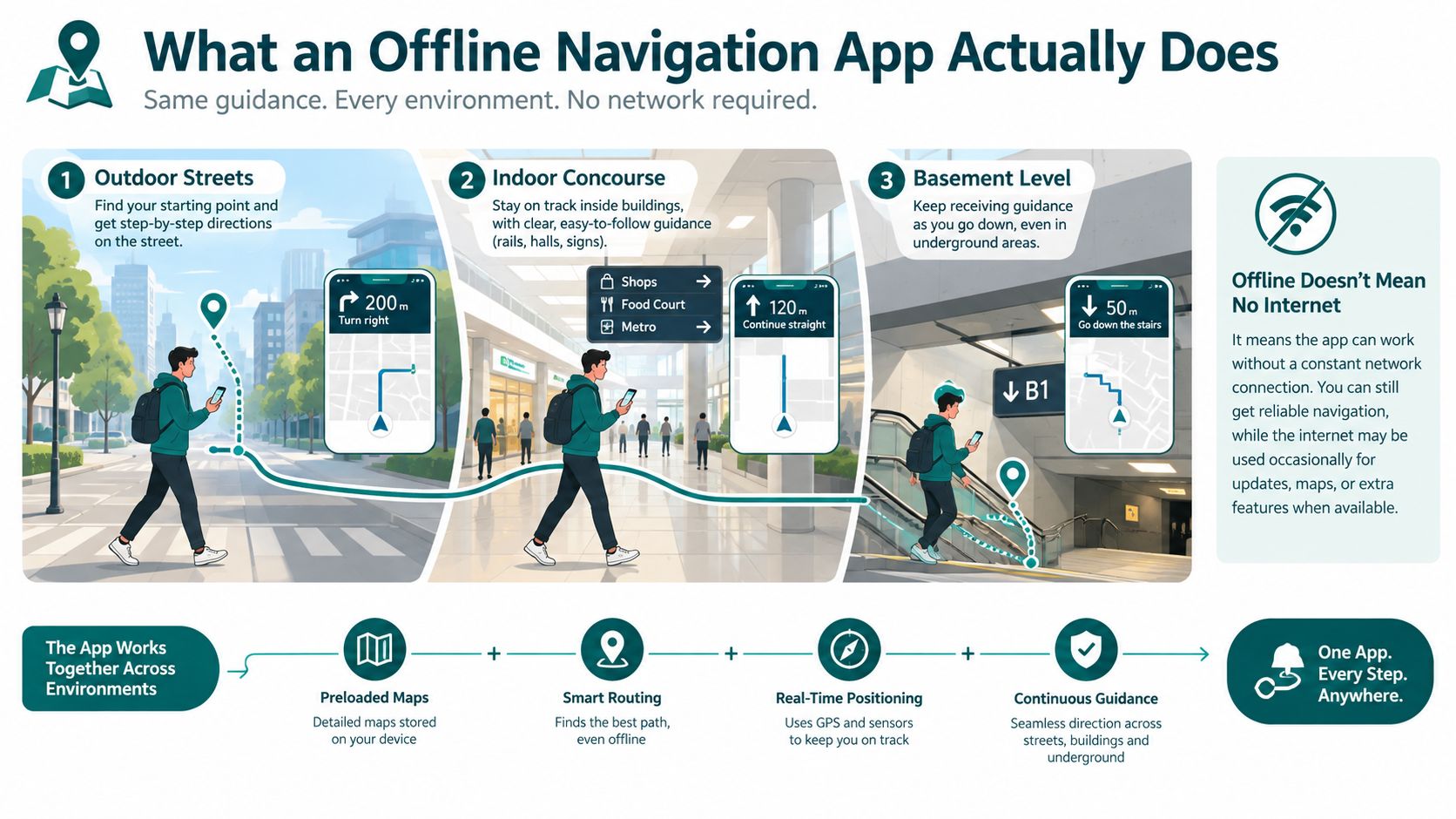
An offline navigation app has a different job. It stores the relevant route information locally, determines movement through available positioning methods, and continues giving instructions when the network disappears. Offline doesn't mean that every part of the service must operate without any internet connection forever. It means the essential journey can continue without constant access to mobile data or Wi-Fi.
The three jobs that matter
A useful offline system must handle three connected tasks:
- Positioning: It estimates where the user is, even after they leave the street and enter a building.
- Routing: It chooses a path that reflects the venue's actual structure, including corridors, stairs, lifts and restricted areas.
- Arrival: It guides the user to the correct last metre, such as a particular entrance, platform access point or hospital department door.
That last task is where generic map apps often fall short. Reaching a station may be easy to describe, but reaching the correct platform entrance or lift from inside the station requires detailed local information and continuous guidance.
A useful analogy is a walking tally. Instead of asking a distant signal to announce your position, the system starts from a known point and interprets movement from the phone's sensors. It can follow the user as they turn into a corridor, climb stairs or move towards a lift, provided the map understands the surrounding geometry.
Practical rule: Test an offline navigation app at the point where ordinary mapping fails, not only at the venue entrance.
For an NHS estates team, that might mean starting outside the Royal Hospital for Children and Young People, entering the main building and finding a specific clinic door. For a transport operator, it might mean moving from a street entrance to a concourse and then to a step-free platform route. The system earns trust by maintaining clear instructions through all three environments.
How Offline Navigation Works From Sensors to Beacons
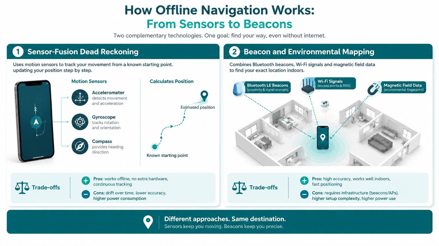
Offline positioning generally follows one of two paths. The first uses sensor-fusion dead reckoning, which combines the phone's accelerometer, gyroscope and compass with a detailed digital map. The second uses environmental signals, such as Bluetooth beacons, Wi-Fi or magnetic-field characteristics, to identify a position inside a venue.
Sensor fusion starts from a known location. The phone detects movement, direction and turns, then matches that movement to the mapped route. Waymap's stated approach uses device-native motion sensors and detailed maps, with guidance that adapts to a person's walking style and movement patterns. Its product description also identifies sub-3-metre accuracy in infrastructure-free environments, while Waymap's sensor-fusion algorithm overview provides further technical context.
Beacon and Wi-Fi systems work differently. The venue installs hardware or relies on an existing signal environment, then calibrates the system against the building. That can provide useful localisation, but the operator must maintain the physical layer when devices fail, move or lose power. A refurbishment, changed corridor or new partition can also affect the measured environment.
The practical trade-off
| Criterion | Sensor-Fusion Dead Reckoning | Beacon / Wi-Fi Positioning |
|---|---|---|
| Physical infrastructure | Uses the user's phone sensors and a detailed map | Requires installed or available environmental signals |
| Deployment | Infrastructure-free, with venue mapping and route testing | Includes hardware installation, calibration and signal planning |
| Maintenance | Focuses on digital map and route updates | Includes digital updates plus hardware condition and coverage |
| Signal-poor spaces | Designed to continue through indoor and underground areas | Depends on the availability and stability of installed signals |
| Last-metre guidance | Matches movement to mapped doors, lifts and platforms | Uses nearby signals to estimate the user's position |
| Change management | Suitable where physical layouts change frequently | Changes may require recalibration or hardware review |
Waymap is described by Innovate UK as a free accessible navigation app that works outside, inside and underground to within 1m of the desired location, according to the Transport for London announcement about its navigation work. That description matters because an arrival point isn't always a building address. It can be the correct door, lift or boarding location inside a complex site.
A sensor-only design also changes the deployment conversation. A hospital with frequent staff movement or a transport hub with ongoing works may prefer a route layer that can be updated digitally rather than a network of devices distributed across the building.
Why Offline Capability Matters for Venues and Transit Operators
A journey can begin on a pavement, continue through a station concourse, descend underground and finish inside a hospital. The phone moves between outdoor, indoor and underground signal conditions, while the traveller still needs one clear route. Offline resilience is therefore an accessibility issue, not just a technical preference.
The Motability Foundation's UK Transport Accessibility Gap report states that disabled people take 38% fewer trips than non-disabled people, a gap unchanged for over a decade. It also reports that 40% of disabled people often experience issues or difficulties when travelling by train.
Poor signage, complex interchanges and unreliable connections can increase that uncertainty. An offline navigation app can keep providing guidance when a traveller needs to find a step-free route, locate a lift or avoid a staircase. The GPS-free navigation approach is designed for these changes in signal state, using a phone's sensors rather than requiring infrastructure throughout the venue.
Physical access still needs digital guidance
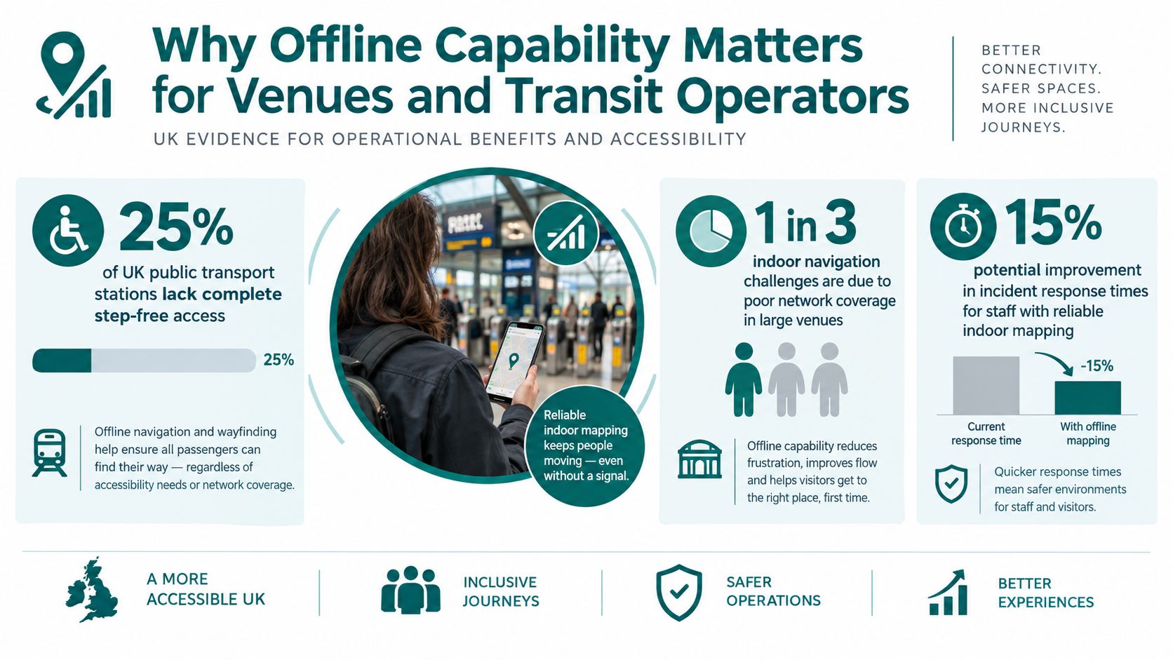
UK rail access remains uneven. Government accessibility data reports that approximately 56% of stations, representing 1,481 stations, provide a good level of step-free access. Around 66% of the 1.3 billion journeys on the network have step-free access to platforms, while level boarding is available at just 4% of stations, according to the UK government accessibility statistics guidance.
A lift only helps when passengers can find it and confirm that the route is open. Transport for London's accessible journey planning guidance says planning should show step-free routes and clearly signpost lifts. It also notes that some Tube stations have platform humps providing level boarding points.
For operators, the cost and upkeep of installed beacons can be difficult across stations, hospitals and other high-footfall sites. Sensor fusion avoids distributing hardware through every corridor, reducing infrastructure maintenance as layouts and services change. The digital route layer still requires careful map governance and accessibility testing.
The Equality Act 2010, WCAG 2.1 AA, BS 8300 and BS EN 17210 offer reference points for inclusive access and digital service design. They do not make an offline app compliant by themselves. Teams must test the complete journey, from route discovery to the correct door, lift or platform, for people with different access requirements.
Deploying an Offline Navigation App Without Disruption
A deployment starts with the venue, not the app store. Estates, accessibility, operations, security and communications teams need a shared view of the places people must reach and the barriers they face. In a hospital, that includes entrances, reception points, lifts, wards, clinics and accessible toilets. In a station, it includes street access, ticket halls, platforms, interchange corridors and assisted travel points.

Build a route model people can trust
Start by documenting the venue topology. A floor plan alone isn't enough. The digital model should represent how a person moves through the site, including floor changes, one-way corridors, doors, stairs, lifts, tactile routes and areas that the public can't enter.
Network Rail describes tactile paving as a way to provide directional information and guide pedestrians along a specific path in its tactile paving wayfinding guidance. The UK government also identifies tactile surfaces as essential guidance and warning features at crossings, platform edges and other hazards in its accessibility action plan consultation. A good digital map should reflect these physical cues rather than treating them as unrelated infrastructure.
A practical rollout can follow this sequence:
- Assess the topology. Identify public routes, access points, vertical circulation and known hazards.
- Collect and verify data. Walk the routes with disabled users, record decision points and confirm the destination labels people use.
- Define update ownership. Assign responsibility for lift outages, blocked corridors, temporary entrances and changed services.
- Pilot a representative journey. Include outdoor, indoor and underground or low-signal conditions where they exist.
- Release in phases. Begin with priority destinations, measure feedback, then expand the route set.
The same governance applies to multilingual guidance. Translate destination names and instructions as part of the content workflow, not as a late interface exercise. Operators such as WMATA and SBS Transit face the same underlying challenge as hospitals and venues, namely that a route is only useful when its instructions reflect the current site and the needs of its users.
Waymap's implementation best practices can help teams structure the operational questions around mapping, testing and updates. Independent UK guidance also flags offline capability as a key requirement, warning that live-connectivity systems can fail in basements and underground transit spaces.
Privacy Maintenance and How to Measure ROI
Sensor-based positioning can support a privacy-by-design approach because the phone can interpret movement locally rather than depending on a network of venue hardware. That doesn't remove the need for governance. Teams still need to define what data the service collects, why it collects it, how long it keeps it and which third parties can access it.
Data minimisation should be explicit. Separate information needed to provide directions from optional analytics, and make consent choices understandable. A venue should also explain how route data supports service improvement, rather than assuming that users will accept broad tracking by default. Waymap's consent management guidance is relevant to teams designing those controls.
Maintenance is part of the business case
Removing beacons can reduce the physical maintenance workload, but it doesn't make the map self-maintaining. Lift outages, construction barriers, temporary entrances and changed departments can make an accurate route wrong. The operator needs a named owner, an update process and a way to publish changes to devices that have stored route data locally.
Measure value through a pilot baseline, not a broad promise. Useful indicators include:
- Wayfinding success: whether users reach the intended destination without staff intervention.
- Journey time: how long representative users take from a defined start point to an exact arrival point.
- Accessible route use: whether people can find and complete step-free paths and lift-based transfers.
- Avoided support demand: whether staff receive fewer directions requests for mapped destinations.
- User experience: feedback from blind, low-vision, wheelchair-using and other disabled participants.
- Operational response: how quickly teams can amend routes after a closure or layout change.
For financial reporting, teams can adapt the simple marketing ROI formulas to their own service objectives. Compare the attributable value of avoided support work, improved visitor experience or additional service use with the implementation and maintenance cost, while keeping operational and accessibility outcomes visible beside the financial calculation.
The interface must also work for the people the route is intended to support. UK indoor wayfinding guidance recommends targeting WCAG 2.1 AA, and says touch controls should be at least 44 by 44 CSS pixels to reduce mis-taps for users with dexterity impairments. Route logic should be tested with disabled users, and hazards near stairs, drops and vehicle routes need sufficient buffering because positioning uncertainty can create unsafe instructions.
How to Choose and Pilot the Right Offline Navigation App
Selection should begin with a failure test. Ask what happens when a traveller leaves a connected street, enters a building and descends underground. If the app loses positioning during that transition, it hasn't solved the operational problem, even if its outdoor map looks polished.
A procurement checklist should include:
- Signal independence: Can the core journey continue without GPS, Wi-Fi, mobile data or installed hardware?
- Last-metre precision: Can the system distinguish a particular door, lift, platform access point or service desk?
- Route detail: Does the map represent stairs, lifts, tactile paths, restricted corridors and temporary closures?
- Update control: Can venue teams amend routes quickly when access conditions change?
- Accessibility testing: Have blind and low-vision users, wheelchair users and people with dexterity impairments tested both route logic and controls?
- Content reach: Can instructions, destinations and important service information support the languages and communication needs of the audience?
- Standards alignment: Does the interface support WCAG 2.1 AA, and does the physical route reflect relevant access guidance?
Set a pilot that can produce a decision
Choose one site with a meaningful mix of conditions. A large station, hospital or shopping centre is more revealing than an easy open-air route because it exposes the connected-to-disconnected transition, vertical movement and last-metre problems.
Define the starting point, destination, route conditions and success measures before testing. Include an estates owner for map changes, an accessibility lead for user testing, an operations lead for closures and a digital lead for app integration. The pilot should include normal journeys and controlled exceptions, such as a closed lift or blocked corridor, so the team can evaluate how updates reach users.
The UK government's app guidance says route-planning apps should consider accessibility needs by suggesting wheelchair-accessible routes and stations and providing step-free options for journeys, as described in its app guidance announcement. That principle should shape the go or no-go decision.
Tom Pey, Waymap founder and blind accessibility technologist, treats inclusive navigation as an operational advantage because a route that works for people facing the greatest barriers often produces clearer guidance for everyone. Teams comparing providers can use Waymap's vendor selection criteria to organise the technical, accessibility and governance questions before committing to a wider rollout.
Frequently Asked Questions About Offline Navigation Apps
What is an offline navigation app?
An offline navigation app provides route guidance when mobile data, Wi-Fi or GPS isn't continuously available. It can support journeys through outdoor streets, indoor buildings and underground spaces when the required maps and positioning logic are available on the device.
Does offline navigation work inside stations and hospitals?
Yes, an offline navigation app can work inside stations and hospitals when it has a detailed venue map and a positioning method suited to indoor movement. The route should include lifts, stairs, corridors, doors and exact destination points rather than only the building address.
Can offline navigation guide blind and low-vision users to a precise door?
Yes, it can provide last-metre guidance when the system models the venue accurately and has been tested with blind and low-vision users. UK transport guidance also treats tactile cues as important wayfinding and warning features, so digital instructions should complement the physical environment.
Does an infrastructure-free app need beacons?
No, an infrastructure-free app doesn't need installed Bluetooth beacons or Wi-Fi positioning hardware. Sensor-fusion systems use the phone's motion sensors and a detailed map, which shifts the maintenance task towards digital route updates.
What should a UK venue check before deployment?
A UK venue should check offline resilience, accessible route logic, WCAG 2.1 AA interface design, update ownership and user testing. It should also verify that lift outages, blocked corridors and changed entrances can be reflected before an outdated route causes confusion.
Waymap provides navigation across indoor, outdoor and underground environments using phone-based sensor guidance, with routes designed for exact doors, platforms and points of interest. Visit Waymap to discuss a focused pilot for your station, hospital, campus or venue and test the connected-to-disconnected journey with the people who use it.
