
No Wifi Signal

You arrive at a large venue with a full mobile signal, open your navigation app, and start walking. At the entrance, the signal disappears. Inside, the map stops updating, the route becomes uncertain, and finding the correct platform, clinic, shop, or door becomes much harder. For a blind or low-vision visitor, that no Wi-Fi signal moment can turn an ordinary arrival into a genuine access barrier.
Public venues often treat connectivity as an IT concern. In practice, it affects wayfinding, independence, staff workload, and accessibility delivery. A reliable broadband connection at the network edge doesn't guarantee that a person can use a wireless service at the point where they need it. Teams responsible for offices can also find useful background in this practical guide to better office WiFi for teams, but large public buildings require a wider response than router optimisation alone.
When Connectivity Disappears Indoors
A visitor reaches a railway station with directions working on their phone. Outside, the route is clear. They enter through a large concourse, pass beneath reinforced floors, and head towards an unfamiliar platform. The phone still has power, but the navigation service no longer has a usable connection. A nearby sighted person may scan signs and ask staff for help. A blind traveller may lose the independent route they had planned.

Outdoor coverage doesn't predict indoor access
Ofcom's Spring 2025 mobile-coverage update, using data collected from the four UK mobile network operators in January 2025, reported that more than 99% of UK outdoor premises had predicted access to combined 4G and 5G coverage at the regulator's “variable” threshold (Ofcom's coverage update). That describes outdoor premises, not continuous service in every place people travel. It doesn't guarantee reception inside buildings, underground facilities, enclosed venues, lifts, or basements.
Ofcom also reported that 96% of the UK landmass had predicted good outdoor 4G coverage from at least one operator, while 5G reached about 62% of the landmass (Ofcom's Spring 2025 Connected Nations update). Those figures establish a national baseline, but they can't tell a visitor whether their phone will work inside a hospital, university, stadium, shopping centre, or interchange.
Operational rule: Treat signal loss as a normal location-specific constraint, not as an exceptional device failure.
The distinction matters most when digital wayfinding is supporting accessibility. A person may have downloaded a venue map, opened an app, and followed the correct route outdoors, then lose the connection at the precise transition where signs, landmarks, and staff assistance become harder to use. The technical reasons behind indoor dead zones are covered in Waymap's explanation of GPS indoors, but the practical point is simple: national coverage doesn't remove local barriers.
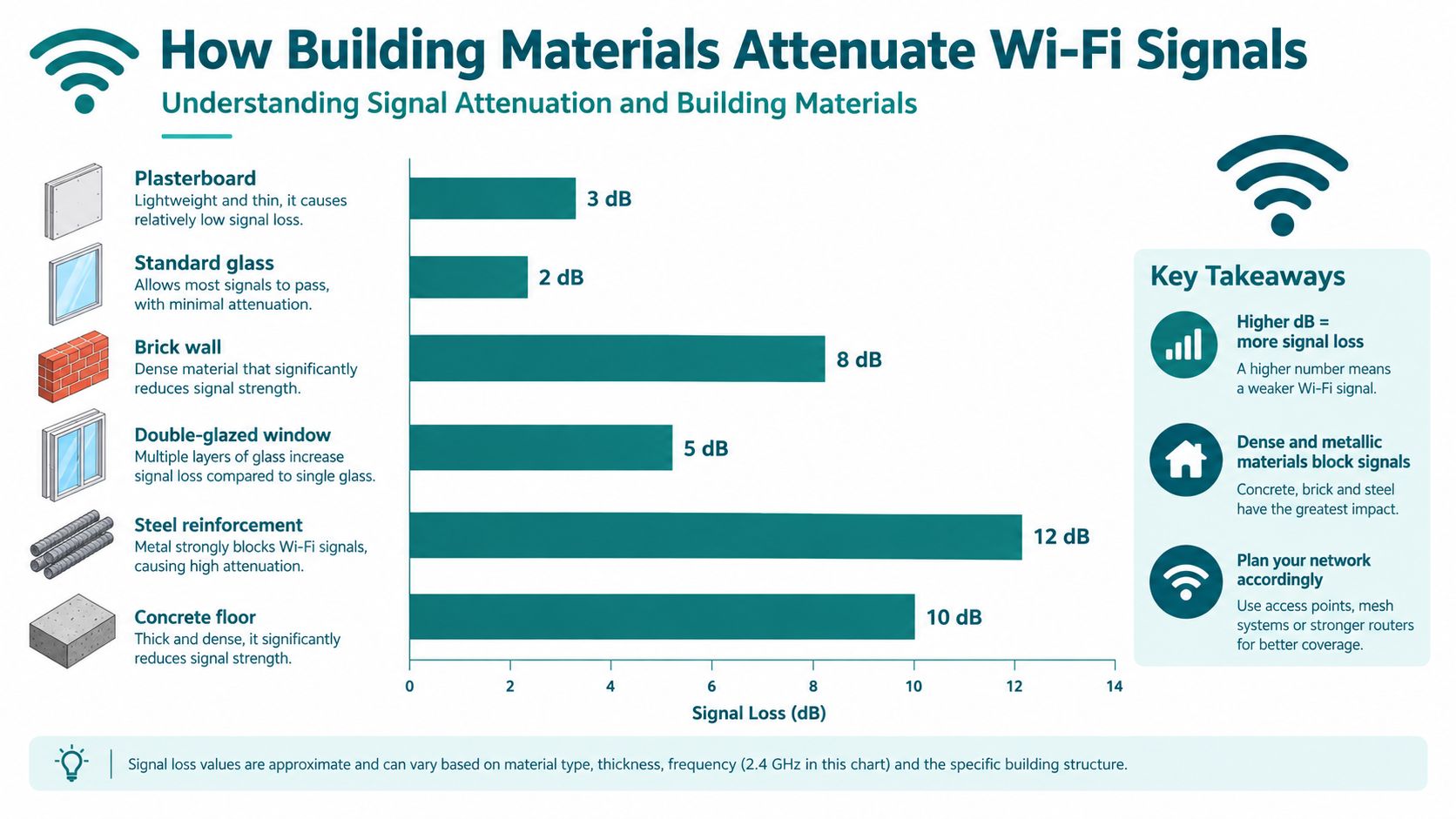
Understanding Signal Attenuation and Building Materials
Indoor signal loss is usually a building problem before it's a handset problem. Radio-frequency energy weakens as it passes through walls, floors, glazing, equipment rooms, structural elements, and crowded spaces. A wireless network can be healthy at the access point and still be unusable at a doorway, lift lobby, stairwell, or underground platform.
Ofcom-sponsored measurements cited in a technical industry report show the difference clearly. At 2.4 GHz, wood attenuates signals by approximately 15 dB per metre, plasterboard by about 22 dB per metre, and glass by around 10 dB per metre (the cited technical report). At 900 MHz, the same measurements found lower attenuation, approximately 5 dB/m through wood, 10 dB/m through plasterboard, and 2.5 dB/m through glass.
Why a small loss can become a dead zone
Decibels are logarithmic, so losses don't behave like a simple linear distance calculation. Each additional wall can reduce received power and lower the signal-to-noise ratio. Once that ratio falls below the threshold required by the wireless modulation scheme, a device may disconnect rather than merely deliver a slower service.
The building's layout also matters. A signal survey that measures only open corridors can miss the places where visitors actually need help. Doorways, fire doors, lifts, stair cores, platform edges, and transitions between floors often combine distance, dense materials, reflections, and interference.
What venue surveyors should measure
Operators should design access-point placement around measured wall and floor losses, not a nominal indoor range. A useful survey records both signal strength and noise or interference, because a strong-looking signal can still be unreliable when competing networks occupy the same channel.
Practical mitigation includes:
- Measured placement: Test coverage at entrances, lifts, stairwells, platforms, toilets, service desks, and other decision points.
- Wired backhaul: Connect access points through a reliable wired network rather than relying on a weak wireless hop between nodes.
- Frequency awareness: Lower-frequency systems generally penetrate walls and floors more effectively, while Wi-Fi performance depends on the band, construction, interference, and client device.
- Transition testing: Walk routes during realistic operating conditions, including busy periods and areas with many active devices.
The result is a more accurate diagnosis. If the radio path is blocked by the structure, increasing the broadband package won't remove the wall, floor, or interference that causes the failure.
Diagnosing Connection Failures Inside Venues
The first diagnostic question is not “Which broadband package should we buy?” It is “Where does the connection fail?” Ofcom separates the service delivered to a router from the experience at a wireless device. Its research identifies Wi-Fi performance, in-home wiring, simultaneous device contention, device limitations, and remote-server performance as distinct causes of poor connectivity (Ofcom's technical report).
Use a two-domain test
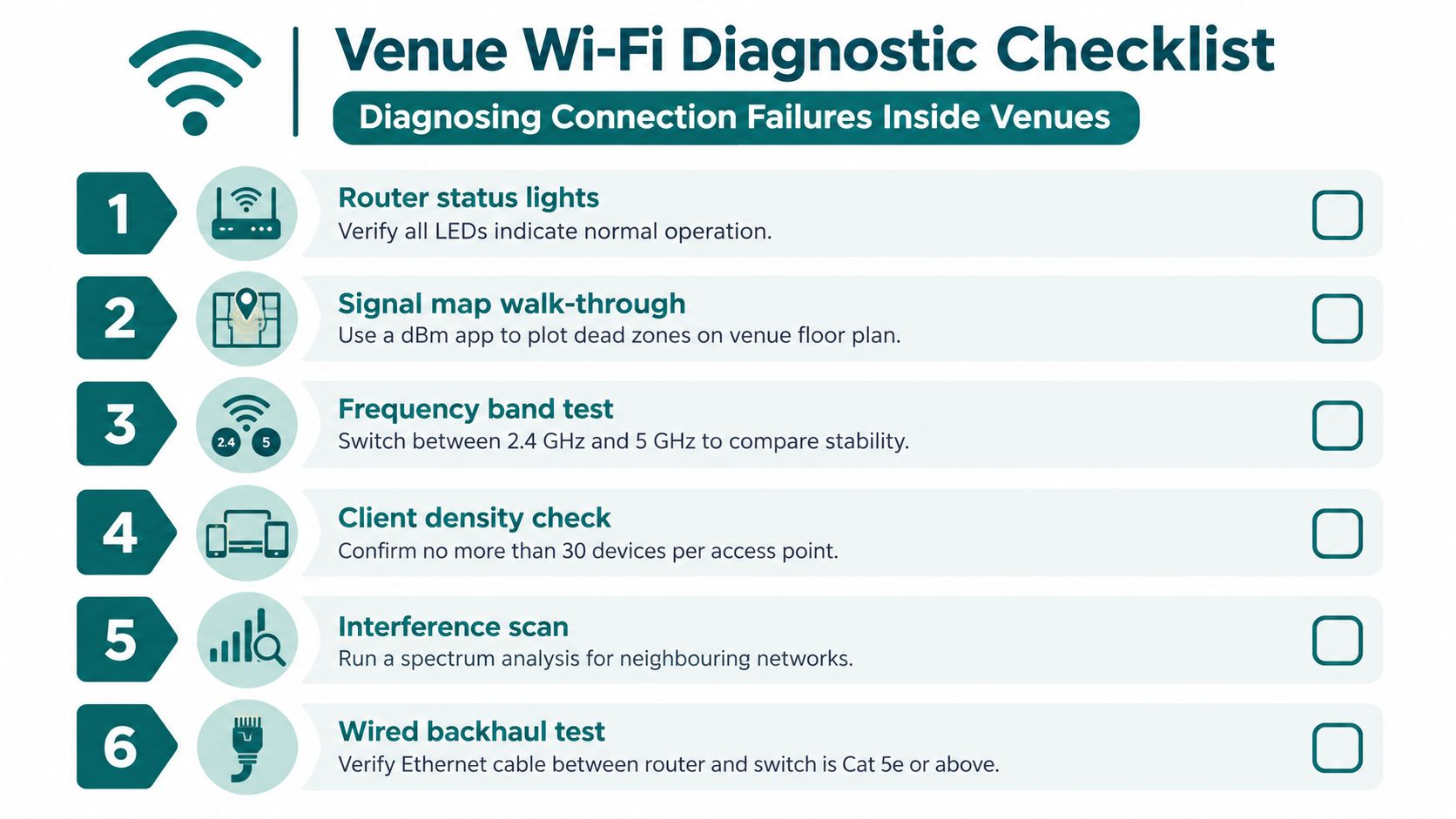
Start at the network edge, then work towards the affected location:
- Test Ethernet first. Connect a test device through a wired connection and confirm whether the router is receiving a healthy service.
- Check SSID visibility. At the problem location, record whether the wireless network name appears at all. A missing SSID points towards coverage, access-point, configuration, or radio conditions.
- Measure received signal and noise. A basic signal survey can show whether the device is distant from the access point or competing with interference.
- Compare bands. Test the available frequency bands separately. A device may hold one band more reliably than another in a particular building zone.
- Reduce client contention. Disconnect one nearby device and repeat the test. If performance improves, simultaneous demand may be affecting airtime.
- Check the backhaul. Confirm that the access point has a stable wired path to the switch and router.
Apply the correct decision rule
If Ethernet is healthy but the wireless SSID disappears, signal quality collapses, or packet loss rises at the affected location, repositioning or adding a properly backhauled access point is more appropriate than upgrading the broadband package. A faster service to the router can't solve a local radio dead zone.
For ongoing operations, monitoring should also capture the time, location, device type, signal level, interference, and user impact. A network-monitoring resource such as this guide from F1Group can help teams think beyond one-off speed tests. The aim isn't to produce a prettier dashboard. It's to identify recurring failure points before visitors and staff report them.
For accessibility services, add a second test: can a person still complete the intended journey if wireless service disappears? If the answer is no, the venue has a wayfinding dependency that its Wi-Fi design alone won't remove. A broader Waymap troubleshooting guide can sit alongside network diagnostics, because navigation resilience and network health are related but separate concerns.
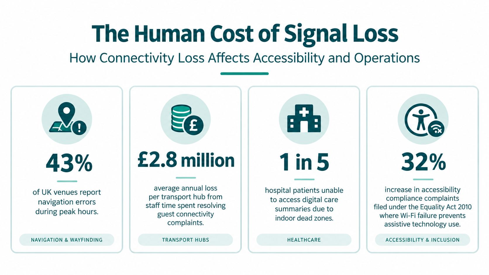
How Connectivity Loss Affects Accessibility and Operations
A visitor doesn't experience a venue as separate systems. They experience one journey from pavement to entrance, ticket gate, platform, reception desk, ward, shop, or exit. If directions work outside but stop inside, the operational failure appears at the point where the person needs precise information about the built environment.
England's 2024 National Travel Survey recorded 712 trips per disabled adult, compared with 999 trips per non-disabled adult, a difference of 29% (Department for Transport disability statistics). Among people aged 60 and over, disabled adults made 653 trips, compared with 1,011 for non-disabled adults, a difference of 35%. These figures don't prove that signal loss causes the travel gap, but they do show why completing the whole journey matters. Finding an entrance or platform isn't an optional digital extra when uncertainty can affect whether someone travels at all.
Accessibility certification isn't the same as usable information
The same distinction appears in bus data. As of 31 March 2024, 99.5% of buses in England had accessibility certification, while only 52.8% provided audio-visual passenger information (the government's disability accessibility statistics). The figures show why physical access and actionable information must be managed separately. A vehicle can meet certification requirements while a passenger still lacks consistent spoken or visual guidance about stops, changes, or onward navigation.
For venue managers, the same principle applies to Wi-Fi. Installing access points may improve connectivity, but it doesn't automatically provide a usable route to an exact door or platform. Under the Equality Act 2010, organisations must consider reasonable adjustments and accessibility in the services they provide. Standards and guidance such as BS 8300, PAS 78, and BS EN 17210 can help teams frame inclusive built-environment decisions, but compliance work should reflect the actual journey, not only the hardware specification.
The operational cost is uncertainty
Signal failures create repeatable work:
- Front-of-house teams answer the same directions questions during busy periods.
- Control rooms receive complaints that appear to be app failures but originate in dead zones.
- Estates teams must investigate whether the problem is coverage, interference, congestion, or a changing layout.
- Accessibility teams have to explain why a digital service is available in theory but unreliable at the point of use.
A resilient plan gives people an alternative route to information. That can include offline content, tactile and audible cues, trained staff, and navigation that doesn't depend on a live network. Waymap's perspective on digital accessibility solutions is relevant here because the access requirement isn't solved by connectivity alone. It requires a service that remains usable when the building defeats the network.
Comparing Navigation Solutions for Signal-Poor Environments
Beacon-based navigation and infrastructure-free navigation solve the same broad problem through different operating models. The choice isn't only about accuracy. It concerns installation, calibration, site access, maintenance ownership, layout changes, and what happens when a battery fails or a device is moved.
Beacon systems carry a physical maintenance burden
Bluetooth beacons can create known reference points inside a building. They may work well where the venue has a stable layout, controlled access to infrastructure, and a team responsible for inspecting and replacing hardware. The weaknesses appear in busy or frequently changing environments:
- Installation: Hardware must be mounted in suitable locations and registered in the system.
- Calibration: The venue needs to validate how devices perform in corridors, rooms, platforms, and transition zones.
- Maintenance: Batteries, damaged units, moved fixtures, and radio interference create ongoing work.
- Change management: A layout change can require a new survey, altered beacon positions, and fresh testing.
- Access dependency: Estates or facilities teams may need to approve work in high-security, listed, underground, or clinical environments.
This burden matters to transport operators and NHS estates managers that already face capital approval cycles, restricted access windows, and competing maintenance priorities. A system can work technically and still fail operationally if nobody can keep its physical layer current.
Sensor fusion removes the external signal dependency
Infrastructure-free navigation uses the smartphone's native motion sensors and algorithmic dead reckoning rather than relying on Wi-Fi, GPS, Bluetooth, or installed radio hardware. The phone estimates movement from steps, direction, and motion patterns against a detailed map. Waymap describes this approach through SmartStep, with sub-3-metre accuracy in infrastructure-free environments and no pre-mapping requirement for venues with high staff turnover or frequent layout changes.
That doesn't mean every navigation problem disappears. A detailed map still needs accurate points of interest, routes need testing, and the user experience must suit different walking styles. The trade-off is that updates can be made in the digital layer rather than by physically relocating a network of devices.
A practical decision matrix
| Venue condition | Beacon-based approach | Infrastructure-free approach |
|---|---|---|
| Stable layout and easy hardware access | May be suitable if maintenance ownership is clear | Suitable where the operator wants fewer physical dependencies |
| Frequent layout changes | Requires repeated physical checks and recalibration | Digital map updates can reflect changes without moving beacons |
| Underground or reinforced structure | Radio coverage may be difficult to maintain | Avoids dependence on external signals |
| High staff turnover | Maintenance knowledge can be lost between teams | Removes the need to manage venue hardware |
| Accessibility-critical routes | Requires reliable hardware at every relevant decision point | Uses the user's device and mapped route logic |
London's Underground illustrates why infrastructure decisions take time. A March 2020 pilot introduced 4G between Westminster and Canning Town on the Jubilee line. A broader rollout followed a 20-year neutral-host concession awarded in June 2021. By December 2022, TfL said only around 10% of Tube stations with underground platforms had 4G and 5G-ready coverage (TfL's December 2022 announcement). Coverage programmes can reduce dead zones, but they require major infrastructure planning. Navigation that remains available without those signals avoids making accessibility wait for the network.
For a broader view of the design problem, navigation without GPS shows why signal-independent positioning is relevant in underground and enclosed environments.
Deploying Waymap for Proven Infrastructure-Free Navigation
Waymap is designed for the failure condition described above. After the app and relevant maps are downloaded, it can provide route guidance without Wi-Fi, mobile signal, GPS, Bluetooth, or other external signals. Its mechanism is dead reckoning through device-native motion sensors, matched against detailed maps. SmartStep learns movement patterns and adapts guidance to the person's walking style, while the underlying system is designed to provide sub-3-metre accuracy in infrastructure-free environments.
That technical model changes the deployment question. The operator doesn't need to extend Wi-Fi into every stairwell or install Bluetooth hardware throughout a venue before offering a route to an exact destination. The work moves towards mapping, route validation, accessible instructions, and keeping the digital points of interest current.
Named deployments and practical constraints
Waymap was first implemented at Lord's Cricket Ground, described by Waymap as the first stadium globally to implement the platform. Its deployment context is instructive: stadiums combine large footprints, crowd movement, multiple entrances, restricted areas, and event-day changes. A navigation layer that depends on installed beacons would add another physical system to an already complex estate.
Waymap has also worked with WMATA, SBS Transit, LTA Singapore, and the Royal Hospital for Children and Young People. These environments differ, but they share the same operational challenge. A visitor may need to find a particular entrance, platform, reception point, clinic, or exit while moving through a place where GPS and wireless signals are unreliable.
For transport operators, the value is not only independence from connectivity. It is the removal of hardware that must be inspected across high-footfall infrastructure. For hospitals and universities, it reduces dependence on installations that can conflict with estates policies or changing layouts. For retail and large venues, an updateable digital wayfinding layer can support changing points of interest, multilingual guidance, and more consistent assistance without asking staff to repeat every route manually.
What implementation still requires
Infrastructure-free doesn't mean preparation-free. Operators still need to:
- Define destinations precisely: “Main entrance” may be too vague. Map the exact door, desk, platform access point, or reception destination.
- Validate routes: Test the route with people who use different mobility and sensory strategies.
- Maintain map content: Remove closed points of interest and update routes when construction or operations change.
- Plan onboarding: Tell visitors where to download the app and how to access maps before entering a signal-poor space.
- Connect support teams: Give frontline staff a clear explanation of what the service does and where it applies.
Waymap's implementation best practices support this operational approach. The strongest deployment isn't the one with the most technology. It's the one that remains useful when Wi-Fi, GPS, mobile signal, and installed hardware aren't available.
For venue operators facing recurring no Wi-Fi signal incidents, Waymap offers offline, signal-independent navigation to exact doors, platforms, and points of interest through smartphone sensors and detailed maps. Visit Waymap to discuss a navigation layer that supports accessibility and remains available inside complex public environments.
