
Navigation Without GPS: Methods, Trade-offs, and Real-World

You're walking through a London Underground interchange with your phone in hand. The blue dot freezes as the train moves into the station, then reappears somewhere that isn't useful: on the wrong platform, outside the entrance, or several metres from the door you need. For a commuter, that's frustrating. For a blind passenger, a visitor in an unfamiliar venue, or an operator responsible for an accessible journey, it's a resilience failure.
Navigation without GPS means using local sensors, maps, fixed infrastructure, visual references, or a combination of these to determine where someone is and guide them along a route. It matters because satellite positioning is weak, blocked, or unreliable indoors, underground, beside tall buildings, and during interference. The UK government's satellite positioning guidance says the country's position, navigation and timing system is almost completely provided by global navigation satellite systems, mainly GPS. It also values the benefits of GNSS at £13.62 billion per year, while estimating the economic impact of a seven-day outage at £7.64 billion and a 24-hour outage at £1.42 billion.
The practical question isn't whether GPS is useful outdoors. It is. The question is what happens when it disappears halfway through a journey.
What Navigation Without GPS Actually Means
GPS-free navigation has two separate jobs, and operators often conflate them.
The first job is location determination. The system needs to estimate where a person stands on a floor plan, whether they're approaching a lift, and whether they've changed levels. The second is route computation. The route engine must turn that position into instructions for reaching a platform, gate, shop, ward, office, or exact entrance.
A printed map can help with the second job only if the user already knows the first. A beacon can help establish location but still needs a reliable map and route model. A useful system must connect both layers and keep them aligned with the physical environment.
Operational rule: Treat GPS-free navigation as a continuity system, not simply an indoor map.
Concrete, steel, thick walls, and some energy-efficient glass can block or distort the signals that satellite navigation needs. The UK government's Blackett Review states that interference can block or degrade GNSS, while buildings and other objects in urban areas create multipath errors that can reach tens of metres. It also says position determination requires at least four satellites, while integrity monitoring requires six to detect and exclude an erroneous measurement.
That's why the blue dot is a poor foundation for door-level guidance in an interchange. GPS may return a plausible position, but plausible isn't the same as useful.
The Waymap explanation of indoor GPS limitations describes the user experience directly: satellite positioning can fail before the journey has finished, particularly when a route crosses from street to station concourse, platform, tunnel, or building interior. Resilient pedestrian navigation starts by assuming those transitions will happen, rather than treating them as exceptional.
The Core Technical Approaches to GPS-Free Wayfinding
Operators usually start with the least complex method, then add integration where continuity, accessibility, or site conditions demand it. The practical question is not which technology looks most precise in a demonstration. It is which combination keeps a pedestrian on route when signals disappear, while fitting the venue's maintenance, compliance, and budget constraints.
Manual methods provide the baseline
Signage, QR codes, and NFC tags are inexpensive, familiar, and straightforward to explain. A QR code can open a venue map, an NFC tag can provide a known starting point, and a clearly placed sign can confirm that someone has entered the correct corridor.
Their weakness is route continuity. A sign cannot tell a person they have passed the lift, and a QR code does not track progress after the user leaves the starting point. These tools work best for orientation, recovery, and fallback guidance, rather than as a complete turn-by-turn system.
Dead reckoning estimates movement locally
Dead reckoning uses the phone's accelerometer, gyroscope, and sometimes magnetometer to estimate movement from a known starting position. The phone detects steps, estimates heading, and advances the user along a digital map.
It requires no ceiling transmitter or positioning-service connection, which can reduce infrastructure and privacy concerns. Drift remains the central trade-off. Errors in step length, heading, or phone orientation grow along the route. Magnetometers can also become unreliable near steel structures, lifts, rails, and electrical equipment. Short indoor paths may be manageable, while long underground corridors need correction from other inputs.
Beacons add reference points
Bluetooth Low Energy beacons, including iBeacon and Eddystone formats, broadcast identifiers that a phone can detect. A system can use signal strength and proximity to estimate whether someone is near a known point.
Beacons can correct drift at junctions, entrances, and platform changes. They also create an estate-management burden. Operators must record mounting locations, manage power, replace failed devices, and update the deployment when a building changes. Radio performance needs testing in crowded, reflective spaces, especially across stations where passengers, trains, and temporary equipment alter conditions.
Visual systems and SLAM use the environment
SLAM, or simultaneous localisation and mapping, uses camera or other environmental data to build a map while estimating position within it. Visual positioning can match columns, walls, signs, or shopfronts against a reference model.
Cameras perform less consistently in poor light, crowded scenes, changing displays, and spaces where visual features move. Holding a phone in a particular position also creates an accessibility limitation. A system that depends on camera use may be unsuitable for hands-free workflows or for pedestrians who cannot keep the device raised.
Map matching turns estimates into routes
Map matching compares a noisy position estimate with walkable paths. If sensors place someone slightly outside a corridor, the algorithm can keep the position on a plausible walkway instead of allowing it to jump through a wall or across a restricted area. The map therefore becomes an operational control, not just a visual layer.
The Waymap overview of sensor-fusion algorithms describes the practical direction for live pedestrian systems: combine motion data with a detailed route map, then update instructions as the person moves.
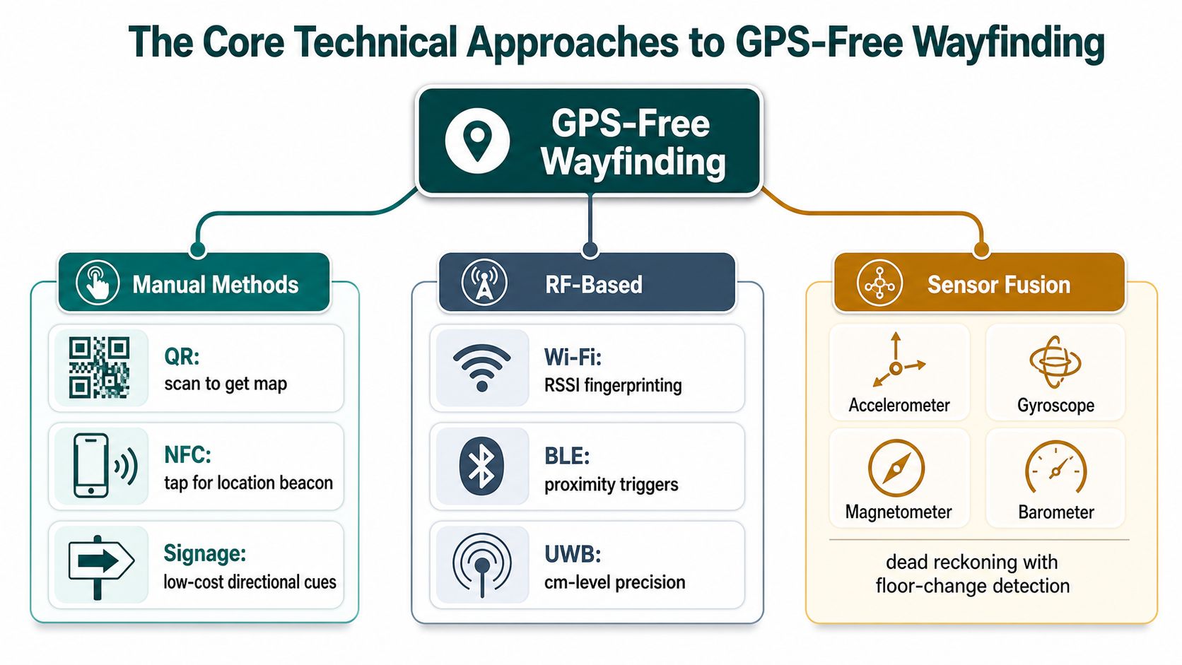
Smartphone sensor fusion combines the inertial measurement unit, barometer, Wi-Fi, beacons, and map logic. The objective is a useful position estimate when individual signals become noisy or vanish. That approach can reduce dependence on installed hardware, but it shifts effort toward software calibration, map upkeep, device testing, and clear recovery instructions.
Comparing the Trade-offs That Decide Which Method Fits
No single method wins on accuracy, cost, maintenance, privacy, and accessibility at the same time. Procurement teams should compare the whole operating model, not just the location estimate shown in a demonstration.
| Method | Typical accuracy | Capex per m² | Maintenance | Privacy | Accessibility reach |
|---|---|---|---|---|---|
| Manual signage, QR, NFC | Point or area guidance | Low | Low to moderate | Strong | Broad, if designed correctly |
| Dead reckoning | Step-level for limited periods, with drift over distance | Low | Low | Strong | Strong when paired with audio and map logic |
| BLE beacons | Often presented as room or junction-level positioning | Moderate to high | Ongoing hardware and battery management | Depends on system design | Useful, but coverage gaps create failure points |
| Visual positioning and SLAM | Dependent on visible features and reference quality | Moderate to high | Map and visual-model upkeep | Camera and data governance required | Variable, especially for hands-free use |
| Sensor fusion | Depends on sensors, map quality, and calibration | Low where infrastructure isn't required | Software and map maintenance | Can keep processing on-device | Strong when designed around different walking styles |
Where each approach breaks
Manual guidance is resilient and easy to maintain, but it can't provide continuous route correction. It also depends on readable, well-placed information. Dead reckoning avoids infrastructure but needs correction and careful handling of stairs, escalators, turns, and different walking patterns.
BLE provides useful reference points but spreads operational work across the estate. A beacon mounted beside a temporary wall or moved during refurbishment can create a misleading anchor. A large venue may also have to manage many devices, even before accounting for battery access and radio interference.
Visual navigation can be precise in a stable, well-lit environment. It's less dependable when shopfronts, advertising, lighting, or pedestrian flows change. Sensor fusion is the engineering compromise many live systems use because it can degrade gradually rather than stopping as soon as one signal disappears.
Privacy also belongs in the design decision. A system that processes motion data on the phone can reduce the need to transmit raw movement information, although operators still need a clear UK GDPR position for maps, analytics, account data, and accessibility preferences. The Waymap analysis of indoor location tracking is relevant to this distinction between tracking a person and providing local route guidance.
Named Deployments That Prove the Approach Works
Real venues expose weaknesses that controlled tests miss. A stadium concourse changes as crowds arrive. Retail units and temporary hoardings move. A metro interchange combines street approaches, ticket halls, stairs, lifts, platforms, and underground passages. These conditions make resilience an operating requirement, not just a technical preference.
Waymap has been used at Lord's Cricket Ground to support movement through dense concourses without BLE infrastructure. For an operator, that removes the installation, battery, inspection, and replacement work associated with a hardware estate spread across public areas that change between events. The trade-off is a greater dependence on accurate mapping and phone-based sensing.
In Birmingham, Waymap's deployment with Hammerson covers the Bullring and Grand Central across more than 1.5 million square feet. The deployment shows why guidance to an exact door matters in a mixed-use environment. Static signs can direct visitors to a centre or zone, but they do not provide continuous instructions when a journey crosses several levels and internal spaces.
| Operator or venue | Environment | Primary approach | Headline outcome |
|---|---|---|---|
| Lord's Cricket Ground | Stadium concourses | Infrastructure-free smartphone sensing and mapped routes | Navigation through dense public areas without BLE infrastructure |
| Bullring and Grand Central, Birmingham | Multi-level mixed-use retail | Sensor-based GPS-free wayfinding | Live deployment across a complex estate covering more than 1.5 million square feet |
| WMATA, Washington Metro | Metro stations and interchange environments | GPS-free mapped pedestrian navigation | A transit-focused deployment addressing complex station movement, documented in the WMATA case study |
| SBS Transit, Singapore | Bus interchanges and connected pedestrian routes | Indoor and signal-poor navigation | A transit use case where continuity matters across covered and busy passenger environments |
The UK evidence base indicates that indoor navigation has moved beyond isolated pilots. The UK parliamentary evidence on indoor navigation reported an indoor-navigation market estimated at nearly £30.5 billion by 2022, with 25% of journeys assisted by a navigation application expected to involve indoor journeys by that point. Network Rail reported that its indoor navigation app had launched at all 20 busiest managed stations and had been used more than 15,000 times, averaging about 2,000 uses per month after launch.
The deployments expose a practical choice. Infrastructure-heavy systems can suit operators with stable radio conditions, maintenance teams, and predictable layouts. Infrastructure-free systems suit estates where footfall, tenancy, access routes, or event layouts change frequently, because route data can be updated without sending staff to each physical device. Neither approach removes operational work. Each places that work in a different budget, maintenance process, and failure mode.
Implementation Guidance for Venue and Transit Operators
Start with the estate, not the vendor demo. Collect current floor plans, platform layouts, entrances, lifts, escalators, stairs, emergency routes, accessible alternatives, and known GPS dead zones. Then audit existing Wi-Fi and BLE infrastructure, but treat reusable infrastructure as an option rather than a prerequisite.
Define the pilot around decisions
A useful pilot should cover one building or interchange and include two user cohorts, assisted and unassisted. Assisted users may receive help during onboarding, while unassisted users test whether the route model and instructions work without staff intervention.
Track measures that reveal failure at the point of use:
- Decision-point error: Measure mean positional error at turns, crossings, lifts, stairs, and platform approaches.
- Reroute response: Record the time between a wrong turn and a clear corrective instruction.
- Task completion: Test whether users reach the intended door, platform, unit, or service point.
- Route quality: Check whether the system selects step-free and obstacle-free alternatives where they exist.
- Operational effort: Record how much staff time is needed to update maps and correct route changes.
- Device impact: Monitor battery drain during long routes and repeated use.
Ask every supplier how the system behaves after a missed step, a sharp turn, a lift journey, an escalator ride, and a transition between outdoor and indoor map areas. Request evidence of cold-start behaviour, drift correction, boundary handling, and recovery when sensors disagree.
Vendor question: Ask what the system says when it cannot verify a route. A confident wrong instruction is worse than a clear request to pause, reorient, or choose another path.
Roll out in controlled stages
Begin with staff testing, then accessibility testing, then a limited public launch. Train customer-service teams to recognise the app, explain starting points, report map changes, and escalate blocked routes. Integrate digital guidance with physical signs rather than removing signs that remain valuable for people without smartphones.
A venue map is a living operational asset. Create ownership for updates when a shop moves, a platform closes, a lift fails, or temporary hoardings alter the walking path. The Waymap implementation guidance is useful for structuring that work around mapping, testing, accessibility, and deployment governance.
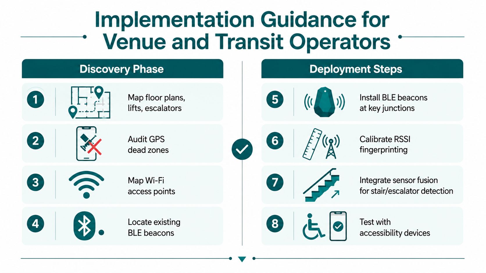
Scale only when users can complete representative tasks, operators can update routes promptly, and the service remains usable across the building's difficult areas. A successful pilot isn't the one with the smoothest corridor. It's the one that exposes the stairs, basements, steel structures, queues, and boundary transitions before a wider launch.
Accessibility, Standards, and Policy Compliance
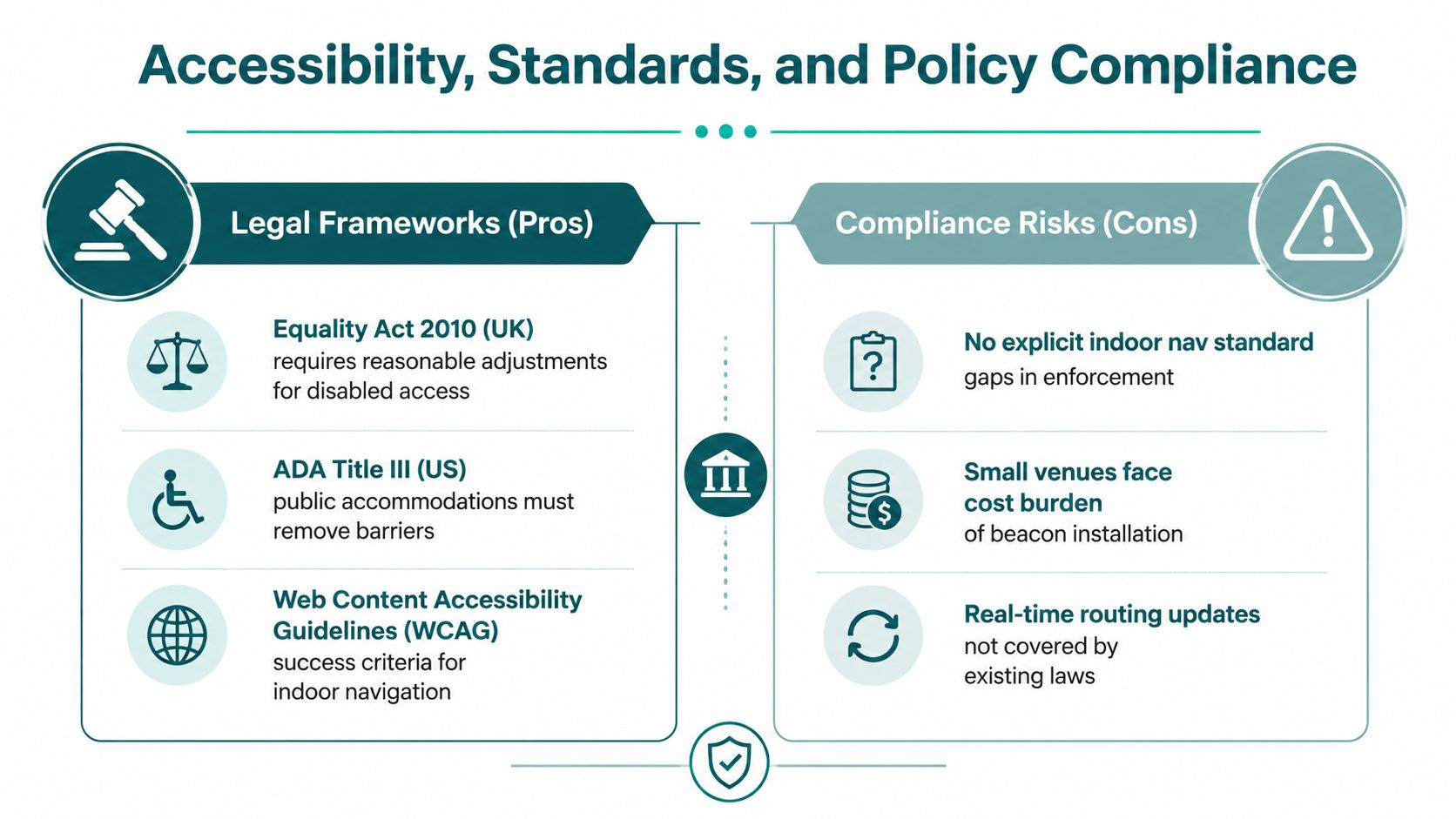
Non-GPS navigation is an accessibility service when a venue expects blind, partially sighted, mobility-restricted, or cognitively diverse visitors to move independently. It shouldn't be treated as a decorative digital feature added after the signs and routes are complete.
In Britain, the Equality Act 2010 provides the legal baseline for reasonable adjustments and accessible services. In the United States, ADA Title III addresses accessibility in places of public accommodation. BS 8300 and PAS 78 provide UK design references, while WCAG offers criteria relevant to a companion app's digital interface. BS EN 17210 also matters where operators are designing accessible built environments.
The case for infrastructure-free navigation is practical. Every physical transmitter introduces another object that can fail, move, lose power, or become inaccessible during refurbishment. A person using a long cane or guide dog shouldn't have to locate a specific beacon before receiving useful guidance. Sensor-based positioning can reduce that dependency, although it doesn't remove the need for accurate maps, accessible routes, usable instructions, and physical safeguards.
UK transport guidance makes the physical environment part of the navigation system. Inclusive Mobility guidance specifies that pedestrian and transport information signs should be well and evenly lit, with uniform lighting between 100 and 300 lux. The same guidance recommends sign panels with a bottom edge 900 mm above ground, a top edge 1800 mm above ground, and a width of 800 mm to 1100 mm, as set out in the standard large-print guidance.
Network Rail's tactile paving and wayfinding guidance states that hazard-warning tactile paving for stairs and platform edges is mandatory in station environments. It also requires information about obstacle-free routes through tactile and contrasting walking-surface indicators as a minimum.
Check the user experience, not just the legal wording
Vendor due diligence should include:
- Screen-reader behaviour: Verify labels, focus order, controls, and route changes.
- Audio instructions: Test volume, timing, repetition, and unambiguous turn language.
- Hands-free use: Check whether a user can follow guidance without constantly looking at the screen.
- Sensor failure: Confirm what happens when the phone miscounts steps or loses heading.
- Accessibility alternatives: Test step-free routes, temporary obstructions, and cases where no fully accessible route exists.
- Data governance: Document what movement data is collected, where it's processed, and how long it's retained.
An app can meet interface criteria and still fail at a platform edge. Compliance work must include the physical route, the live map, the instructions, and the recovery path when reality changes.
Frequently Asked Questions About Non-GPS Navigation
How does navigation without GPS work underground?
Navigation without GPS works underground by combining smartphone motion sensors with a detailed map and route logic. The phone estimates steps, direction, turns, and level changes locally, while map matching keeps that estimate on walkable paths. Operators can add beacons or other signals, but a resilient design shouldn't assume that a satellite lock or continuous external signal will return inside a tunnel.
Are BLE beacons required for GPS-free navigation?
BLE beacons aren't required for every GPS-free navigation system. They can provide useful reference points and correct accumulated drift, but they also create installation, power, placement, and maintenance obligations. A sensor-fusion approach can use device-native motion sensors and mapped routes instead, which is particularly relevant in venues with frequent layout changes or limited capital for physical infrastructure.
What accuracy does accessible indoor navigation need?
Accessible indoor navigation needs reliable guidance at decision points, not a plausible position somewhere inside a building. The required performance depends on the task: finding a lift, selecting a platform entrance, avoiding a staircase, or reaching an exact door each creates a different tolerance. Operators should test route accuracy at turns, level changes, hazards, and accessible alternatives with the people who will use the service.
Does GPS-free navigation create UK GDPR concerns?
GPS-free navigation can reduce privacy exposure when motion processing happens on the phone, but UK GDPR responsibilities still apply to the wider service. Operators should document location-related data flows, analytics, accounts, consent, retention, and vendor access. A system that avoids Wi-Fi or mobile positioning isn't automatically privacy-compliant, so the assessment must cover the complete product and operating model.
Is this suitable for hospitals and transit interchanges?
GPS-free navigation suits hospitals and transit interchanges when the operator maintains an accurate map and tests the service against real route conditions. Both environments contain changing access arrangements, lifts, restricted areas, corridors, and high-consequence decision points. The pilot should include reception, entrances, platforms or departments, accessible routes, temporary closures, and staff escalation procedures.
How does sensor fusion handle multi-level buildings?
Sensor fusion handles multi-level buildings by combining movement patterns, map constraints, and level-change cues such as stairs, lifts, and barometric information. The difficult part isn't detecting that a person moved. It's assigning that movement to the correct floor and route branch. Testing must include escalators, lifts, staircases, mezzanines, and phones carried in different positions.
When does GPS-free navigation add measurable value over a printed map?
GPS-free navigation adds measurable value when users need live, hands-free guidance through changing, multi-level, or signal-poor environments. A printed map remains useful for overview and orientation, but it can't adapt instructions after a wrong turn, confirm progress to an exact door, or reflect a lift closure in real time. Operators should compare task completion, rerouting, accessibility, and staff assistance rather than treating digital guidance as a replacement for every sign.
Waymap provides turn-by-turn pedestrian navigation indoors, outdoors, and underground using smartphone motion sensors and detailed maps, without depending on GPS, Wi-Fi, mobile signal, or installed beacons. If your venue or transit network needs a maintained route layer for exact doors, platforms, and accessible paths, visit Waymap to discuss a practical deployment.
