
Melbourne F1 Track Guide to Albert Park Circuit

You can stand at Albert Park on a race-week morning and feel the whole venue shift under your feet. Trams arrive full, people spill off at the wrong stop, the new Anzac Station pull of passengers feeds into the park edge, and the question on the pavement is never really about lap times. It's about which gate leads to the right grandstand, how long the walk will be, and what to do when the printed map stops helping and the crowd starts asking each other for directions around the Melbourne F1 track.
That's why the melbourne f1 track is better understood as a temporary city-scale venue than as a racing surface alone. The circuit sits inside a public park, so every race week forces a live negotiation between motorsport, access control, crowd safety, transit flow, and basic wayfinding. If you work in venue operations, transport, or accessibility, Albert Park is useful because it exposes the same problems large precincts face everywhere, just under a brighter spotlight and a tighter timetable.
Inside Albert Park on a Race Weekend
By the time the first wave of fans reaches the precinct, the Melbourne F1 track has already stopped feeling like a park loop and started behaving like a controlled event district. People come off the tram, cut across pedestrian routes from the new station, and then slow down at the perimeter because the last hundred metres are where confidence drops. That's the point where staff get asked the same set of questions again and again, which gate, which side of the lake, and whether the grandstand is on this line of fencing or the next one.
The biggest operational mistake is assuming the crowd already understands the geography. They usually don't, even if they've watched the race for years, because the temporary overlay changes the logic of the place. Barricades, exclusion zones, sponsor structures, and temporary signage turn familiar park paths into a maze that only looks simple from a distance.
Practical rule: if a visitor has to ask twice, the first layer of wayfinding has already failed.
The venue also has to work with the fact that the park is not the same thing every day. Independent coverage has noted that Albert Park is ordinarily part of a public park, and that the circuit can be walked and cycled outside race build-up, but it is transformed for race use during construction and event week. That tension matters because the track is not only a motorsport asset, it is also a public space with a community memory attached to it. For a practical example of how operators think about this sort of live precinct mapping, the approach used in a 3D heat map is a good reference point for understanding movement pressure, not just static layout.
When you're on the ground, the main challenge is not locating the circuit. It's finding the correct entrance, at the ideal moment, before the crowd density at the edge begins to determine everyone's pace.
The Layout and the Corners That Define a Lap
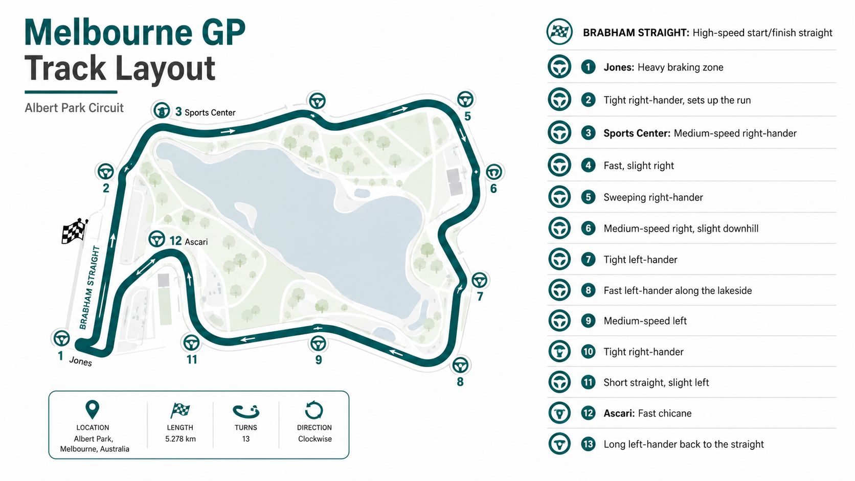
A lap at Albert Park changes character fast. The track is short enough that one poor exit or late brake point alters the rhythm of the whole run, and that matters both for drivers and for anyone trying to read the venue on foot. Formula 1's official guide lists Albert Park at 5.278 km, with 14 turns, 58 laps, and a total race distance of 306.124 km (Formula 1 circuit guide). Another official page gives the post-2023 layout as 5.303 km, 16 turns, and 307.574 km over 58 laps (Formula 1 Australia circuit page). On the ground, that translates into a lap built from speed, braking, traction, and a series of decisions that have to be made before the car reaches the corner.
Start on the Brabham Straight
The post-2023 Brabham Straight reset the opening phase of the lap. Red Bull's track guide points to a 1.3 km straight, a wider circuit, and a pit-lane speed limit increase from 60 to 80 km/h, which pushes more emphasis onto straight-line efficiency and less onto a car that only wants to rotate in medium-speed corners (Red Bull track guide). The average speed is cited at about 160 km/h, with top speed around 330 km/h with DRS, so the circuit can look calm on a map and feel harsh once the field is fully committed.
Turn 1 is the first heavy brake zone. It compresses the pack immediately, and for a spectator trying to orient themselves it is also where gate names, grandstand labels, and fence lines start to matter in a very practical way. A walk from the park edge to Turn 1 can look direct before it meets the fenced funnel and the crowd slows to the pace of the queue.
Move through the technical middle
Turns 2 and 3 demand balance more than bravery. The car has to settle quickly, and the spectator has to read the circuit as a sequence of boundaries rather than as one continuous loop. Static signs struggle here because people inside the precinct are usually looking for the next landmark, not the one they already passed.
The lake-side sequence changes the feel again, with more openness and more exposure to whatever the car carries out of the previous section. The chicane near the lake, including the Ascari-labelled section used on many circuit maps, is the part of the lap where rhythm matters more than outright aggression.
For teams planning crowd movement as well as racing lines, 3D lidar scanning is the kind of method that makes sense in this environment because it captures the edges, barriers, and temporary shifts that paper maps miss.
The lap is easiest to understand if you split it into chunks. Straight, braking, rotation, sweep, then the lake-side technical section.
The official circuit map remains the most useful visual reference. A drone-style onboard clip shows speed, but a top-down map shows the problem, sequencing rather than spectacle. That is why route-finding around Albert Park gets harder the closer you are to the action, even though the circuit itself is not especially long.
What the Numbers Say About Racing and Operations
Albert Park is one of the clearest cases where the racing profile and the venue operation sit on top of each other. Reuters, via Formula 1's facts and stats roundup, reported that the Australian Grand Prix at Albert Park carried a 67% Safety Car probability, had 45 overtakes completed in 2025, and produced a pit-stop time loss of 19.30 seconds, including 2.5 seconds stationary (Reuters via Formula 1 facts and stats roundup). That mix is a good reminder that this event is rarely a calm procession.
The operational consequence is straightforward. When the field bunches, movement inside the venue bunches too. Marshals face more pressure at restart moments, spectators move in bursts, and the narrow windows between cars on track often mirror the narrow windows for pedestrians outside the fence.
Why Melbourne rewards efficiency in the lane and in the stands
Formula One's official statistics page lists Lewis Hamilton as the most successful pole-sitter at Albert Park with 8 poles, and Michael Schumacher as the most successful race winner with 4 wins (Formula 1 stats page). Those figures matter because they show how much this circuit has rewarded pace, track position, and clean execution over time.
For operators, the lesson is blunt. Melbourne does not forgive sloppy timing. A short lap means every gain or loss shows up again quickly, whether that is a clean exit, a delayed pit release, or a pedestrian crossing that stalls for a minute too long. The same logic applies to crowd handling. If one pinch point backs up, the effect spreads fast because the precinct has little spare room for people to absorb delay before choosing the next route.
| Metric | Value | Operational Implication |
|---|---|---|
| Safety Car probability | 67% | Restart control matters, and crowd movement can bunch around interruptions. |
| Overtakes in 2025 | 45 | The track supports on-track action that keeps spectators attentive and moving. |
| Pit-stop time loss | 19.30 seconds | Pit execution has a visible strategic cost, and timing windows are tight. |
| Stationary pit time | 2.5 seconds | Small service delays matter because the delta is brief. |
| Pole positions by Lewis Hamilton | 8 poles | Melbourne has a deep qualifying pedigree. |
| Race wins by Michael Schumacher | 4 wins | The venue has a strong competitive record across eras. |
The numbers do not make Melbourne dramatic on their own. They make it operationally unforgiving. Fast lap behaviour and fast crowd behaviour tend to collide on the same weekend, and that is why the precinct rewards clear routing, quick decisions, and reliable wayfinding. For that kind of movement planning, the structure behind public transportation directions is useful because it treats transfers as part of the trip, not an afterthought. It also fits the logic behind eco-friendly commuting advice from Punk Ride, where the transfer matters as much as the vehicle.
Getting There by Tram, Train, Foot, and Bike
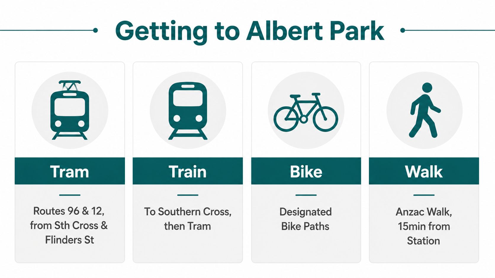
The best arrival plan is the one that assumes your first choice may be crowded. Southern Cross and Flinders Street remain the natural rail anchors for most visitors, then the tram or a walk takes over. For an event with this many moving parts, the practical question is not whether a mode exists, but whether it gets you close enough to the gate you need.
Use the tram when you want the simplest transfer
Trams are still the default for most spectators, especially from the city grid into the park edge. Route 96 and Route 12 are the names people usually remember, and the best use of them is as a last-mile connector rather than a door-to-door promise. If you're planning a multimodal trip, the logic is similar to eco-friendly commuting advice from Punk Ride, where the transfer matters as much as the vehicle.
Use the train when you want to reduce guesswork
The new Anzac Station changed the conversation for the 2025 event because it gave people another way to approach the precinct before the crowd hits the tram stops. That matters on a venue like Albert Park, where the access routes can bottleneck fast near the Queensbridge Street and St Kilda Road corridor. For a navigational model that treats the transfer as part of the trip rather than an afterthought, the structure behind public transportation directions is closer to how attendees experience the day.
Use walking and cycling when your arrival window is flexible
Walking from South Melbourne or along St Kilda Road works best when you are early and you already know which edge of the circuit you want. Cycling can also be a good option where local conditions and designated paths make it sensible, but you need a real plan for lock-up, access control, and post-race departure. The park perimeter is not forgiving when people all choose the same entrance at once.
Practical rule: if you're arriving close to session start, choose the route that reduces decision-making, not the one that looks shortest on the map.
The venue works best when visitors think in terms of arrival zones, not just transport modes. At Albert Park, the right answer depends on which part of the circuit you're trying to reach before the gates become the main bottleneck.
Spectator Areas, Gates, and Crowd Flow After the 2023 Review
At Albert Park, the useful spectator question is not which seat sounds impressive. It is where movement stays predictable, which entrances clog first, and how the gate you pick shapes the rest of the day. Grandstands near Turn 1, Turn 9 and 10, and the Turn 11 zone all pull crowds in different ways because people follow the most obvious action points and the most familiar access lines.
Track access also changed the way people move. ABC reported in 2025 that fans were allowed back onto the circuit after a 2023 safety ban (ABC News). That sounds minor until the race ends and the same transport spine has to absorb a full exit wave at once.
Why track access changes crowd behaviour
When spectators can walk the circuit, they spread out differently. They stay longer, look around more of the precinct, and treat the track edge as part of the event rather than only a barrier around it. That adds atmosphere, but it also changes the pressure on gates, crossings, and marshalling points because the venue has to serve people who want to leave quickly and people who want to linger.
Albert Park works better when the operator separates movement layers clearly. Entry, circulation, viewing, and departure are different jobs even when they share the same ground. If those layers are not managed well, the precinct gets harder to read just as the afternoon exit surge begins.
The same principle shows up in evacuation planning. Temporary fencing, open park edges, and changing access points leave less room for guesswork, so route clarity matters before people ever need to leave fast. That is why the operational logic behind emergency evacuation planning belongs in the spectator discussion, not just in a safety appendix.
For event operators, the core issue is the full movement chain, from gate assignment to after-race egress, and whether the precinct can absorb people without forcing them to improvise. The same applies to community-scale transport planning, including electric fleet options for communities, because the right arrival and departure mix reduces pressure on the same pinch points spectators hit first.
Accessibility, Wayfinding, and the Infrastructure-Free Approach
A race weekend at Albert Park exposes the weakness in any guidance system that depends on fixed infrastructure. The circuit sits inside a working park, so routes that look stable on a normal day can change once fencing, gates, and crowd controls go in. Large venues in the UK and similar markets still work within accessibility frameworks such as the Equality Act 2010, BS 8300, and PAS 78, but Albert Park asks for a different operating model because the physical environment is temporary rather than permanent.
That is why infrastructure-free navigation makes practical sense here. Waymap uses dead reckoning with device-native sensors, and it is designed to function without GPS, Wi‑Fi, or installed hardware. In venue terms, that lets operators update points of interest, route guidance, and access information without rebuilding the system every time the event footprint shifts. It suits a precinct that changes shape through build-up, race week, and tear-down.
Why fixed hardware struggles at Albert Park
Every race week changes something. Gates move, fences shift, access points are renamed, and temporary paths appear where there was open parkland a few days earlier. Bluetooth beacons and similar fixed devices can work in a stable building, but Albert Park is not stable once the circuit goes live.
For blind and low-vision visitors, the problem is rarely only the door itself. The harder part is knowing where to turn after leaving the tram stop, how to read a temporary concourse, and whether the path that worked on arrival still exists after the crowd has built up. General visitors feel the same friction at the edges of the precinct, where uncertainty slows everyone down and creates avoidable congestion.
Operational takeaway: if the map changes faster than the hardware can be maintained, the wayfinding layer becomes a liability instead of support.
The link with wider transport planning is direct. electric fleet options for communities shows how access, maintenance, and sustainability trade-offs tend to sit together, not separately. Venue navigation works the same way. A hardware-heavy approach may look tidy on paper, yet it can create an ongoing burden when the route network is temporary and the event team has to keep it accurate under time pressure.
For routes that lose signal or become unreliable indoors and outdoors, the practical comparison is a GPS-denied setup like GPS-denied navigation for changing venues. That matters at Albert Park because wayfinding has to keep working where beacons, live positioning, and static signage each fail in different ways. The goal is not decorative technology. It is dependable guidance when spectators move from tram stop to gate, gate to stand, and stand back to exit under changing conditions.
The value of infrastructure-free wayfinding is simple. It keeps pace with a venue that changes by the week, not just by the year. That matters most at Albert Park, where the event footprint is temporary but the accessibility expectation is fixed.
Practical Tips and the Road Ahead for 2026
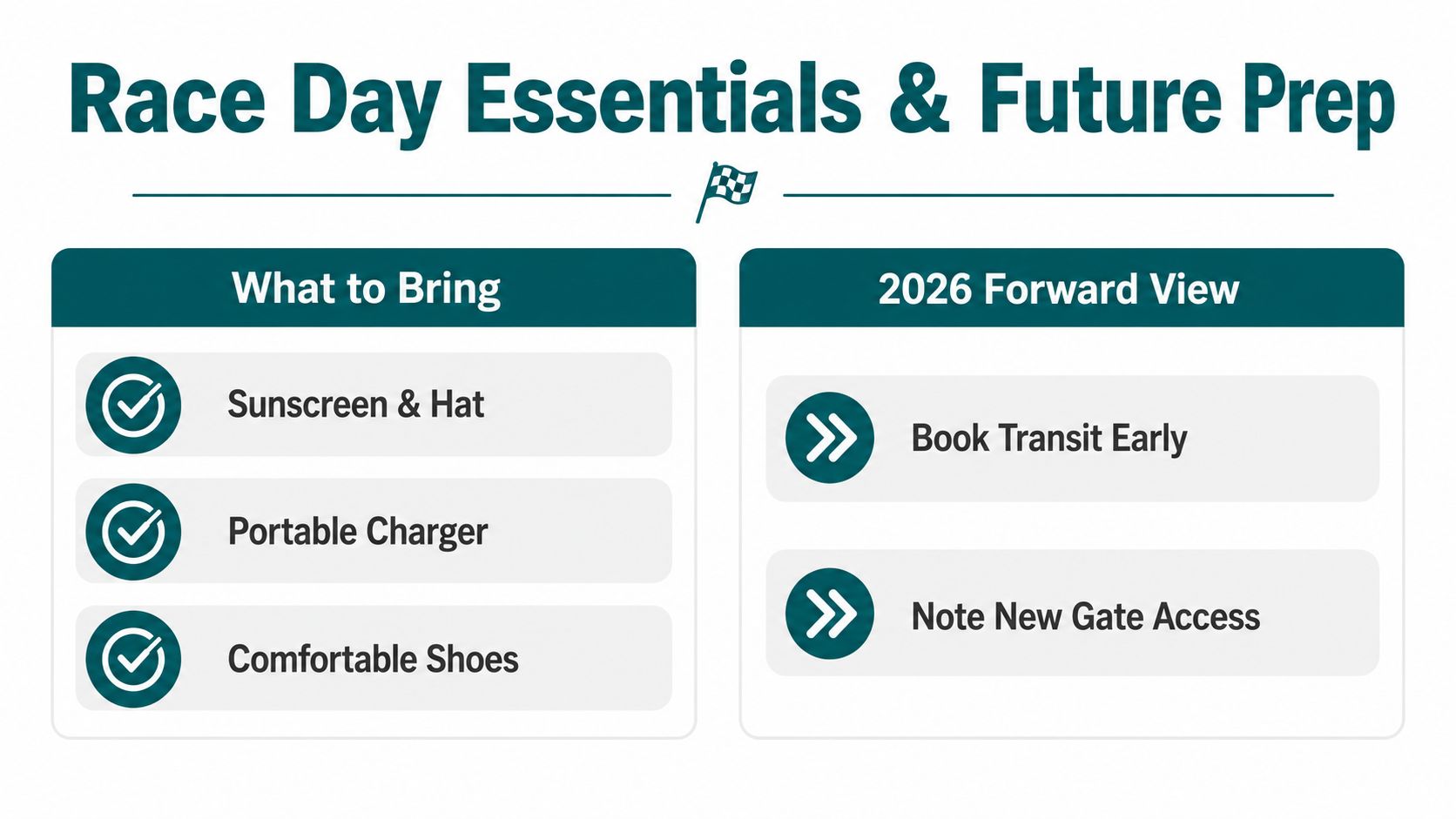
Arrive early, and don't assume the route you used last year is still the easiest one this year. If you're heading to a Turn 1 or lake-side grandstand, target the gate that matches that side of the precinct rather than crossing the whole venue on foot after arrival. Bring sunscreen and a hat, a portable charger, and comfortable shoes, because the walking is often more demanding than the ticket suggests.
What to check before you book
Book transit early if you can, especially if you want to align your arrival with the new rail access pattern rather than relying entirely on the tram queue. Check whether your ticketed area has a clear, step-free route from the station or stop, and confirm whether the gate you need is the nearest one to your stand. If you need accessible navigation across changing indoor-outdoor routes, that's the point where dynamic, infrastructure-free guidance becomes more useful than a printed map.
What 2026 is likely to demand from the venue
The 2026 Australian Grand Prix will keep pushing the same operational question. How do you move more people cleanly through a precinct that is still partly a park and partly a race venue? With Anzac Station now part of the pattern, precinct works still shaping the fan experience, and static signage giving way to digital layers, operators will keep needing route guidance that can be updated faster than the build plan.
If you manage a venue, transit service, or accessible visitor route, Waymap gives you a way to guide people indoors, outdoors, and underground without installing fixed hardware across every temporary change. Visit Waymap if you want to see how that approach fits a live, changing precinct like Albert Park and similar large-event sites.
