
Optimizing Indoor Wayfinding: Your Gps Denied Navigation

Most transport and venue leaders don't have a theory problem with GPS-denied navigation. They have a live operations problem. People can't reliably find the right platform, exit, clinic, gate, concession, or accessible entrance in the parts of the estate where satellite positioning drops out. Staff then absorb the failure through repeated directions, wayfinding complaints, and avoidable friction at exactly the busiest points in the journey.
That's why GPS-denied navigation matters. It's not a niche robotics topic. It sits inside everyday public transport, healthcare, retail, education, and civic access. For organisations responsible for complex buildings and interchanges, the main question isn't whether GPS fails indoors and underground. It does. The question is which navigation approach still works when it fails, and what that choice costs to deploy, maintain, and trust over time.
What Is GPS-Denied Navigation?
GPS-denied navigation means navigation in places where satellite signals are unavailable, unreliable, or too unstable to support precise guidance. In practice, that includes much of normal life indoors and underground.
If you stand inside a station concourse, a basement corridor, or a shopping centre, you're already in a GPS-denied environment. Concrete, steel, glazing, dense roofing, and underground structures block or distort signals before they reach the phone. Even when a device reports a location, it may not be accurate enough for turn-by-turn guidance to a specific door or platform.
Why GPS fails in ordinary buildings
There are two common causes.
- Signal blockage means the phone can't see enough of the sky to receive a usable satellite fix.
- Multipath error means the signal arrives after bouncing off nearby surfaces, so the position estimate shifts away from where the user is.
A simple way to explain it is this. GPS works best when the device has a clean view upward. Inside a multi-storey car park, underground station, or enclosed mall, that condition disappears.
The result isn't just a weaker blue dot. It's a navigation experience that becomes too vague to be useful for exact decisions such as which staircase to take, which side of the concourse to follow, or which door is the accessible entrance.
Why this matters in the UK
The practical user problem in the UK is often finding exact platforms, exits, and doors in places where GPS is weak or absent, including Underground stations, rail interchanges, malls, and campuses, as described in this research summary on cooperative GPS-denied navigation.
For buyers comparing solutions, that's also where many articles become unhelpful. They explain the science, but not the operational questions. What accuracy is realistic? What setup burden sits with the venue? Does the system need installed infrastructure? Those are the questions that determine procurement outcomes.
A useful starting point is to separate GPS-denied navigation from general indoor positioning systems. Some indoor systems still depend on installed hardware or local radio signals. GPS-denied navigation is the wider requirement. It asks what still works when satellite positioning is gone and the environment itself is difficult.
Practical rule: If a user needs exact indoor or underground guidance, assume GPS is the wrong foundation unless the system can keep navigating without it.
Why Is Reliable Indoor Navigation a Mandate Not a Feature?
For public-facing organisations, reliable indoor navigation isn't a premium extra. It's part of delivering access on equal terms.
That becomes obvious at transport scale. The UK Department for Transport reported 71.1 million rail passenger journeys in Great Britain in 2023–24, and London Underground carried 3.3 million passenger journeys on an average weekday in 2023–24, according to the cited transport figures in this SRI reference. In environments like that, even small wayfinding failures affect very large numbers of people.
Passenger flow is an operational issue
A missed platform, wrong exit, or uncertain interchange doesn't stay personal for long. In a crowded network, it becomes dwell time at decision points, repeated staff interventions, congestion at pinch points, and lower confidence in the journey.
Decision-makers often underestimate this because analogue coping mechanisms are familiar. Staff members point. Signage teams add another sign. Temporary notices appear during disruption. Those measures matter, but they don't provide personalised, continuous guidance from current location to exact destination.
For blind and low-vision passengers, that gap is sharper. Static signage can't substitute for turn-by-turn instructions. For many other users, including first-time visitors, older travellers, and people under time pressure, the problem is similar even if the barrier presents differently.
Accessibility duties already push the issue
In the UK, the Equality Act 2010 changes the standard from convenience to equitable access. In the US, decision-makers usually think in terms of ADA Title III. In both cases, the core expectation is similar. Access to the built environment shouldn't depend on whether someone can interpret visual signage, ask for help, or tolerate uncertainty.
That matters in transport, hospitals, shopping centres, campuses, and civic buildings. If the digital layer fails in the same places where the physical environment is most complex, the service isn't complete.
Reliable indoor wayfinding should be judged as part of access provision, not as a nice digital add-on for a minority of users.
The mandate is operational as well as legal
Leaders at organisations such as Transport for London and WMATA don't need convincing that complex estates require better wayfinding. The harder question is how to deliver it without introducing another fragile system to maintain.
That's where procurement often goes wrong. Buyers focus on feature lists instead of service obligations. The better framing is simpler:
- Can users reach exact destinations independently
- Can the operator maintain the system without constant field work
- Can the approach support accessibility objectives in the estate the organisation operates
If the answer to any of those is no, the feature set doesn't matter much.
How Different GPS-Denied Navigation Technologies Work
A person leaves a train, enters a busy interchange, loses satellite signal within seconds, and still needs turn-by-turn guidance to the correct platform, lift, or exit. That is the operating problem GPS-denied navigation is trying to solve.
Different technologies solve it in different ways. For a decision-maker, the important question is less about technical elegance and more about what each method asks the estate team, IT team, and accessibility budget to carry over time.
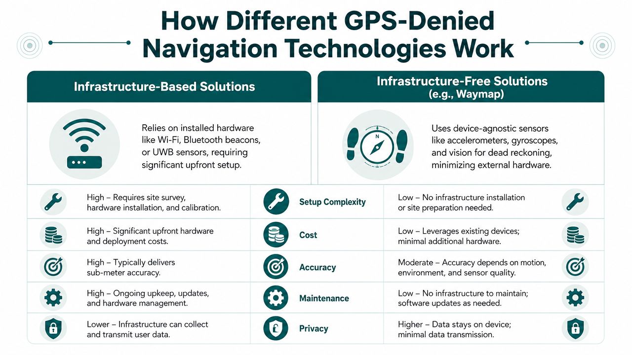
Infrastructure-based systems
Infrastructure-based systems locate a user by referencing hardware placed around the venue. That usually means Bluetooth beacons, Wi-Fi positioning, ultra-wideband anchors, or similar fixed equipment.
They can work well in controlled spaces. Airports use them. Warehouses use them. Some hospitals and malls do too. The trade-off is operational. Accuracy depends partly on hardware staying installed, powered, mapped correctly, and unaffected by changes in the building.
| Approach | How it locates users | What the venue must do | Typical weakness |
|---|---|---|---|
| Beacon-based positioning | Detects nearby installed transmitters | Install, manage, replace, and audit hardware | Maintenance overhead |
| Wi-Fi-led positioning | Uses access points or signal fingerprints | Maintain signal consistency and coverage | Environmental variability |
| UWB and similar systems | Uses dense local infrastructure for precise location | Commit to specialist hardware rollout | Cost and complexity |
In practice, that creates a finance question as much as a technical one. A beacon estate is not a one-off purchase. It is batteries, audits, replacements, remapping after refurbishments, and fault finding when users report poor guidance in only one corridor or one entrance. In public transport and large venues, those costs tend to sit with teams that already have more statutory work than budget.
A more detailed look at the sensor side sits in this article on inertial measurement units, which are central to infrastructure-free approaches.
Infrastructure-free systems
Infrastructure-free systems try to locate the user without installing hardware throughout the building. The main approaches are inertial navigation, map matching, and SLAM, short for simultaneous localisation and mapping.
Inertial navigation uses motion sensors already present in the device, such as accelerometers and gyroscopes, to estimate movement step by step and turn by turn. It is attractive because it avoids field hardware. The weakness is drift. Small measurement errors build over distance, so the estimated position gradually moves away from the user's true position.
SLAM reduces that problem by comparing sensor data against features in the environment. Depending on the system, those features may come from cameras, LiDAR, depth sensing, or other inputs. NASA describes visual and LiDAR-based SLAM as a standard way to localise where GNSS is unavailable, especially when a system must keep correcting its own position against the surrounding environment rather than waiting to reacquire satellite signal (NASA overview of GPS-denied navigation and terrain-relative methods).
That distinction matters in public venues. A station concourse, hospital atrium, or shopping centre is not a static lab. Lighting changes. Crowds obscure lines of sight. Temporary hoardings appear. Camera-based methods can be very capable, but they depend on the environment offering enough stable features and on the device being used in a way that supports sensing.
This video gives a useful visual sense of the challenge and the options:
Why sensor fusion usually wins
After years of working on accessible wayfinding, I have found that no single sensor is reliable enough on its own across every part of a live estate. The systems that hold up best usually combine methods.
The practical hierarchy is usually this:
- Pure inertial only works over shorter spans, but accumulated error limits it.
- SLAM and feature-based systems perform well where the environment offers stable visual or structural reference points.
- Inertial plus map matching is often the most durable model for public venues because it constrains drift against the known geometry of the site.
That last point matters for accessibility and ESG outcomes. If a navigation service depends on installing and maintaining hardware across every building, scaling it across an estate becomes slow and expensive. If it can run from software and existing consumer devices, rollout is easier to justify across more sites, including older stations, council buildings, hospitals, and venues that would never win capital approval for a full hardware deployment.
One infrastructure-free option in this category is Waymap, which uses device-native motion sensors for dead reckoning and guides users without relying on GPS, Wi-Fi, Bluetooth, or installed hardware. For buyers, the key point is the operating model. Software-led navigation reduces the amount of physical infrastructure the organisation has to buy, maintain, and eventually replace.
The useful comparison is hardware estate versus software estate. That difference usually decides whether a pilot stays a pilot or becomes a service.
What Are the Real-World Barriers to Deployment?
Most deployments don't stall because the concept is weak. They stall because the delivery model collides with estate reality.
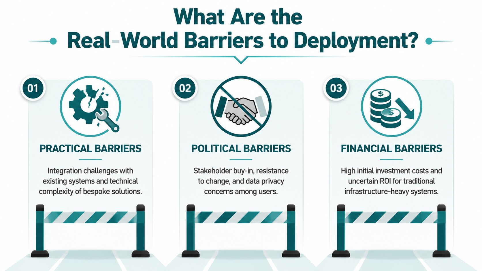
Practical barriers inside live estates
A transport operator can't treat a station like a lab. An NHS site can't treat a hospital like a showroom. Buildings change. Temporary works appear. Clinics move. Retail units turn over. Access routes are revised during events, maintenance, or incidents.
Hardware-based navigation introduces field dependency into that environment. Someone has to install devices, check them, replace them, and keep the digital layer aligned with physical changes. In a high-footfall estate, that doesn't stay tidy for long.
The same logic applies to networks with multiple entrances, mezzanines, underpasses, and partial refurbishments. A solution that looks cheap at procurement can become expensive through maintenance labour and operational fragility.
Political and budget barriers
At this point, many otherwise sensible programmes lose momentum.
For an estates team, beacon rollouts often land as capital expenditure in a budget cycle already committed to statutory works, backlog maintenance, or service-critical equipment. For transport operators, the issue is rarely just the purchase. It's the ongoing commitment to access windows, safety approvals, contractor coordination, and asset ownership.
If a navigation system needs widespread installed hardware, the business case has to survive not only procurement but also internal politics. Who owns it after launch. Who pays for replacement. Who signs off changes. Who carries the support burden.
A useful counterpoint sits in this overview of Bluetooth access points, which helps explain why radio-based infrastructure can create hidden operational obligations.
Resilience is now part of the decision
There's also a wider resilience issue. The UK National Cyber Security Centre stated in 2024 that over 90% of global trade by volume moves by sea and warned that GNSS disruption and interference from jamming and spoofing are increasingly practical threats to transport, logistics, and critical infrastructure, as cited in this summary of GNSS disruption risks.
That doesn't mean every venue needs to solve maritime navigation. It does mean dependency on satellite signals is now recognised as a vulnerability, not just a convenience layer.
For public bodies and critical operators, that changes the conversation. GPS-denied navigation is no longer only about indoor usability. It's also about continuity when the primary positioning layer is weak, blocked, or intentionally interfered with.
Buyers should ask a blunt question. If GPS becomes unreliable and local infrastructure fails or drifts out of maintenance, what still works for the public?
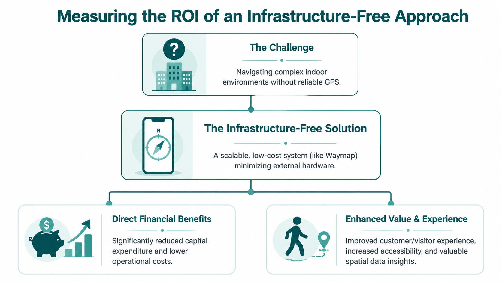
Measuring the ROI of an Infrastructure-Free Approach
The strongest business case for infrastructure-free navigation isn't a single headline saving. It's the removal of recurring friction across access, operations, and maintenance.
Where the return actually shows up
Decision-makers often look first for a narrow payback model. That's understandable, but too limited. Indoor navigation affects more than one budget line.
An infrastructure-free approach can improve value in several ways:
- Lower deployment burden because there's no venue-wide hardware programme to install and maintain.
- Faster operational updates when points of interest, routes, or access arrangements change.
- Better accessibility delivery because guidance can be personalised rather than left to signage alone.
- Reduced staff interruption where frontline teams currently spend time giving repeat directions.
- Stronger ESG and inclusion evidence because access is being improved in a practical, user-facing way.
Those benefits don't all sit in one department, which is why weak sponsorship often underestimates them. Estates sees one thing, operations sees another, accessibility teams see a third. Good procurement joins them up.
Why infrastructure-free tends to age better
In my experience, the long-term value comes less from launch and more from what happens after launch. A system that avoids batteries, field recalibration, and hardware replacement usually stays serviceable with less friction.
That matters in places with frequent changes, including shopping centres, campuses, hospitals, and transport interchanges. If routes can be updated digitally without rolling engineers or installers through the site, the service is easier to keep accurate.
This is the practical case set out in Waymap's explanation of reliability, scalability, and maintenance in infrastructure-free wayfinding. The underlying point is simple. Lower maintenance dependency is itself an ROI driver.
ROI should include social value
Accessibility programmes are often forced into defensive language. Compliance. Risk reduction. Reasonable adjustment. Those matter, but they're not the whole story.
A navigation service that helps people reach the right entrance, platform, clinic, lecture theatre, or retail destination more independently improves the quality of the visit. For some users, that means confidence and dignity. For operators, it supports service quality, inclusion goals, and a more credible ESG narrative.
The strongest cases I see are not framed as “accessibility versus business performance”. They recognise that inclusive navigation is part of good operations.
How to Choose and Pilot the Right Navigation Solution
A transport operator approves a pilot after a strong demo. Six weeks later, staff are still escorting passengers because the trial only proved the system could work in a quiet test area, not during live disruption, route changes, and peak footfall. That is the mistake to avoid.
A good pilot is a buying process in miniature. It should show whether the system can support real journeys, fit the venue's operating model, and stay accurate without creating a new maintenance burden.
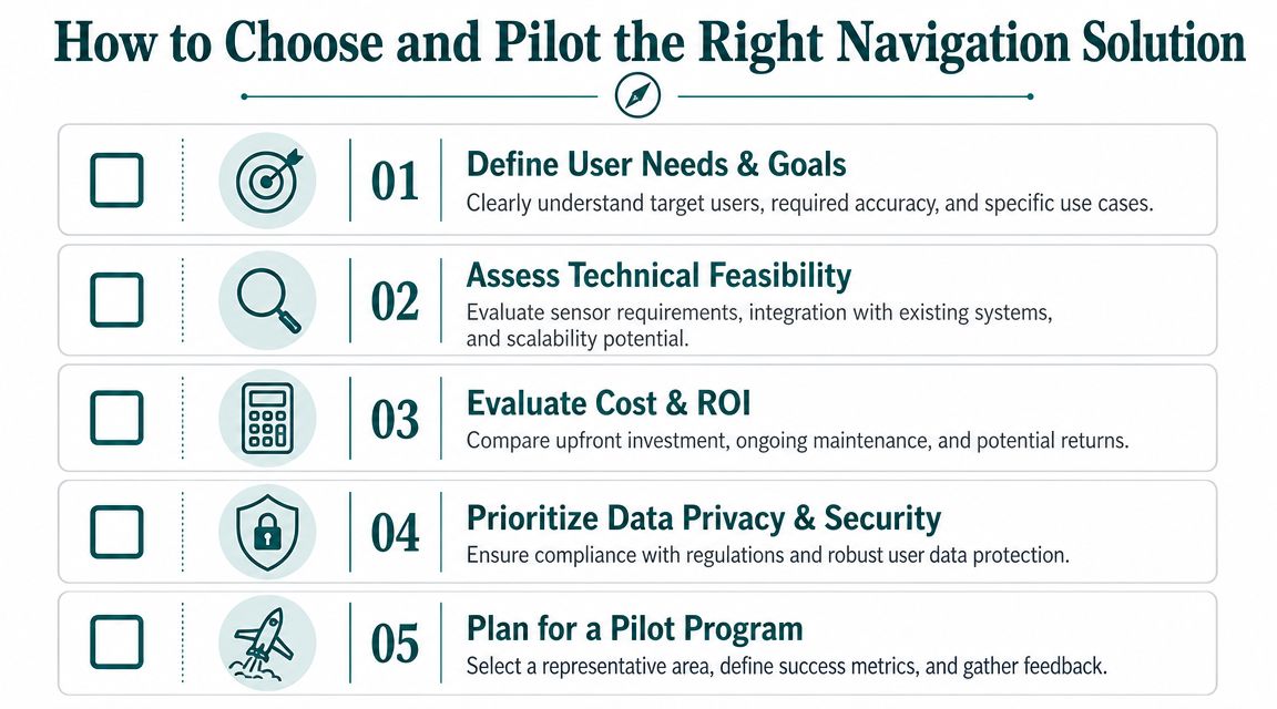
The criteria that matter most
Start with five decision questions.
Does it guide to exact destinations
Room-level guidance is often not enough. In stations, hospitals, and campuses, the ultimate test is whether a user reaches the correct door, platform access point, lift, reception desk, or clinic entrance without staff intervention.What is the total cost of ownership
Budget lines rarely stop at software. Include hardware replacement, battery checks, site surveys, recalibration, contractor callouts, map updates, and the internal time needed to keep the service current. Consequently, infrastructure-based options often lose their appeal. They can look affordable at procurement stage and become expensive in live operation.How does it control drift and recover position
Any system using phone sensors over longer indoor routes has to correct accumulated error. Buyers do not need a lecture on SLAM, but they do need a plain answer to one question. How does the system get the user back to the right position after a long corridor, a crowded concourse, or a missed turn? If the answer depends on ideal conditions, the pilot will expose it.How quickly can the estate be updated
Venues change constantly. Temporary closures, platform works, pop-up barriers, decants, and one-way systems are normal operating conditions. Ask who can make those edits, how fast they go live, and whether every change requires someone on site.Can the system deliver accessibility outcomes
General indoor wayfinding and accessible wayfinding are not the same purchase. If blind and low-vision users are treated as a secondary test group, the pilot will miss the journeys that matter most and the service gaps that create reputational risk.
Buyers who want a clearer view of what sits underneath the user experience should review this guide to an internal navigation system for complex venues.
A practical pilot model
Keep the pilot tight, but make it operationally honest. Pick an area with difficult decision points, live footfall, and at least one journey that already creates friction for passengers or visitors. Good examples include entrance to platform, reception to clinic, car park to accessible entrance, or interchange to the correct exit.
Use three groups in the evaluation:
- Accessibility participants, including blind and low-vision users
- Operational staff, who understand disruption, incident response, and frontline workload
- Venue managers, who own change control, signage, and digital updates
Then score the pilot against outcomes that matter to the business. Did users arrive at the correct destination. How often did they need help. How long did updates take after a route change. Could venue staff manage those updates themselves. Did the pilot reduce dependency on physical infrastructure, or did it introduce another asset base to maintain.
That last point matters more than many procurement teams expect.
If a navigation product needs hardware across the estate, the pilot should price that model comprehensively from day one. Include failed devices, battery replacement, engineering access, asset records, and account for public spaces rarely being static. An infrastructure-free approach changes that equation. It reduces installation friction, shortens the path from pilot to scale, and gives accessibility teams a stronger business case because the service is easier to maintain across more locations.
Frequently Asked Questions about GPS-Denied Navigation
What is GPS-denied navigation in simple terms?
GPS-denied navigation is navigation that still works when satellite positioning is blocked, weak, or unreliable. That usually means indoor, underground, or heavily built-up environments where a phone can't get a precise enough GPS signal.
Is GPS-denied navigation only relevant for defence or drones?
No. Often, the everyday version of GPS-denied navigation is finding a platform, exit, door, or service point inside a station, hospital, campus, or shopping centre.
What usually works better indoors, beacons or infrastructure-free navigation?
It depends on the estate and the operating model. Beacon-based systems can work, but they add hardware installation and maintenance. Infrastructure-free systems reduce that burden, which often makes them more practical in large, changing venues.
Why do inertial systems need map matching or re-localisation?
They need it because drift builds over distance. Even strong inertial performance degrades over longer routes unless the system can correct itself against the structure of the environment.
What should a buyer test in a GPS-denied navigation pilot?
Test exact destination accuracy, update speed, maintenance burden, user confidence, and accessibility performance. A pilot should prove that the system works in live operational conditions, not just in a controlled demo.
If you're reviewing options for Waymap, start with the hard questions: can it guide to exact destinations without GPS, can your team maintain it without adding hardware overhead, and can it improve access for everyone using the space. Those are the questions that determine whether a navigation system survives beyond the pilot.