
Indoor positioning systems: A Practical Guide for Modern Venues
Ever had that sinking feeling when the reliable blue dot on your phone’s map vanishes the second you step inside a building? We've all been there. This is the promise of indoor positioning systems (IPS): a kind of ‘indoor GPS’ that picks up right where satellite navigation leaves off.
Think of it as the missing piece of the puzzle for getting around today's sprawling airports, underground transit hubs, and massive shopping centres, providing a reliable sense of direction where GPS signals simply can't reach.
Why Indoor Positioning Matters Now More Than Ever

For decades, we’ve relied on GPS to guide us through cities and across entire continents. But the moment we walk into a large, complex building, that digital lifeline disappears. It’s a huge gap in our connected world, one that often leads to confused visitors, stressful journeys, and real operational headaches for venue owners.
Indoor positioning systems are built to solve this exact problem. By offering precise, step-by-step guidance inside buildings, they help people find their departure gate, train platform, or a specific shop with confidence. This isn’t a futuristic luxury anymore; it’s becoming a fundamental need for anyone running a large public space.
Meeting Modern Demands
The push for smarter, more efficient, and more welcoming public spaces is what’s driving the interest in IPS. Venue operators are under constant pressure to improve how people experience and move through their facilities. A well-designed IPS helps meet several needs at once:
- A Better Visitor Experience: It reduces the stress and confusion of navigating a complex layout, empowering people to find their way around on their own.
- Smarter Operations: When visitors can find their own way, staff spend less time giving directions and more time on their core responsibilities. Better visitor flow also helps ease congestion at key points.
- Real Accessibility and Inclusion: For travelers with visual impairments or other disabilities, reliable indoor navigation provides the freedom to travel independently.
An indoor positioning system transforms a static building into a dynamic, navigable environment. It’s about more than just a map; it's about providing autonomy, efficiency, and a truly inclusive experience for every visitor.
A Rapidly Expanding Market
This demand isn't just anecdotal; the market growth is significant. In the UK alone, the indoor positioning market was valued at USD 1,634.5 million in 2024. Projections show it reaching USD 10,711.4 million by 2030, a compound annual growth rate of 38.6%. You can explore more of these figures on Grand View Research.
This growth highlights the urgent need for smart infrastructure in public transport, airports, and other large venues where GPS is ineffective. As our buildings become ever larger and more intricate, traditional signage can't keep up.
Indoor positioning offers a digital, scalable solution that not only meets the expectations of modern visitors but also lays the groundwork for the smart buildings of tomorrow. In this guide, we'll explore the core technologies that make it all happen.
Understanding the Technologies Behind Indoor Positioning
To understand what indoor positioning can do, you need to look at how it works. Outdoors, GPS has the luxury of a clear line of sight to satellites. Indoors is a different challenge entirely, relying on a range of technologies to determine someone's location inside a building.
Think of these technologies as different ways of following "digital breadcrumbs" through a sprawling airport or a complex subway station. Some technologies require special hardware installed on-site, others use existing wireless networks, and some modern approaches just use the sensors already in a smartphone. Understanding these options is the first step for any organization looking to bring this navigation into their venue.
Hardware-Based Systems
This is the traditional approach. It involves placing small, physical devices throughout a building to create a signal grid that a phone can read. The most common of these are Bluetooth Low Energy (BLE) beacons.
- How they work: Beacons are small, battery-powered transmitters broadcasting a simple ID signal. An app on a smartphone listens for these signals, and by measuring the strength of several nearby beacons, it can estimate its location—much like how your ears can determine where a sound is coming from.
It’s like scattering tiny lighthouses around a building. Each one flashes its unique light, and by seeing which ones are brightest, a ship (your phone) can chart its position. It’s a proven method, but for a large venue, this means installing and maintaining hundreds, if not thousands, of these devices. Each one also has a battery that will eventually need to be replaced.
Then there’s Ultra-Wideband (UWB). It’s far more precise than BLE, often down to a few centimeters, but it has its own requirements. UWB needs dedicated anchors placed around a space to track a specific tag. This is useful for tracking high-value assets in a warehouse, but less practical for public navigation where people bring their own phones.
Network-Based Systems
A more streamlined approach is to use the wireless networks that most large venues already have. Instead of installing new equipment, these systems leverage the existing Wi-Fi infrastructure to determine a user’s location.
"The appeal of network-based systems is the potential to reduce deployment costs by using existing infrastructure. However, you have to be aware that accuracy can be inconsistent, depending on the age and density of the Wi-Fi access points."
One of the more promising technologies here is Wi-Fi Round-Trip Time (RTT). This method measures the exact time it takes for a signal to travel between a smartphone and several Wi-Fi access points. By converting that time into a distance, an app can calculate its position with reasonable accuracy, usually within one to two meters.
The main benefit is avoiding a massive hardware rollout, but it all depends on having a modern, RTT-compatible Wi-Fi network. If you’re using older equipment, you may be limited to a less reliable method based on signal strength, which can be inconsistent.
Infrastructure-Free Systems
Some of the most significant developments in indoor positioning have been around approaches that need no installed hardware at all. No beacons, no special Wi-Fi, nothing. These systems rely entirely on the powerful sensors already inside every modern smartphone.
This is where sensor fusion comes in. Your phone’s internal sensors—the accelerometer (measuring movement), gyroscope (measuring rotation), and compass (measuring direction)—produce thousands of data points every second. Smart algorithms then "fuse" all this data with a detailed digital map of the venue to track a user’s position and movement with high precision.
Imagine walking through a building blindfolded. You'd still have a sense of when you walk forward, turn a corner, or go up a ramp. Sensor fusion is like an enhanced version of that internal sense, constantly plotting every step and turn on a map. Because it doesn’t need any external signals, it works perfectly even in signal-dead zones, like deep underground in a transit station.
The growth across all these technologies is telling. The UK indoor positioning and indoor navigation (IPIN) market is projected to grow at a compound annual rate of over 41% between 2025 and 2030. While software-only solutions currently lead, recent market reports show that service-based models are quickly gaining traction as organizations seek the benefits of positioning without the headache of managing hardware. You can dig into the full IPIN market growth breakdown on The Business Research Company.
How to Compare Indoor Positioning Approaches
Choosing the right indoor positioning system isn't about chasing the latest technology. It's about making a smart, strategic decision that fits your venue's reality – your budget, your operational needs, and your long-term vision.
What works for a sprawling airport won't be the right fit for a busy underground station or a university campus. You have to look past the hype and weigh the real-world trade-offs. It’s the only way to find a solution that delivers genuine value, both for your visitors and your bottom line.
This flowchart offers a straightforward way to start thinking through your options. The key question is whether you can build on existing infrastructure or if you need a system that stands on its own.
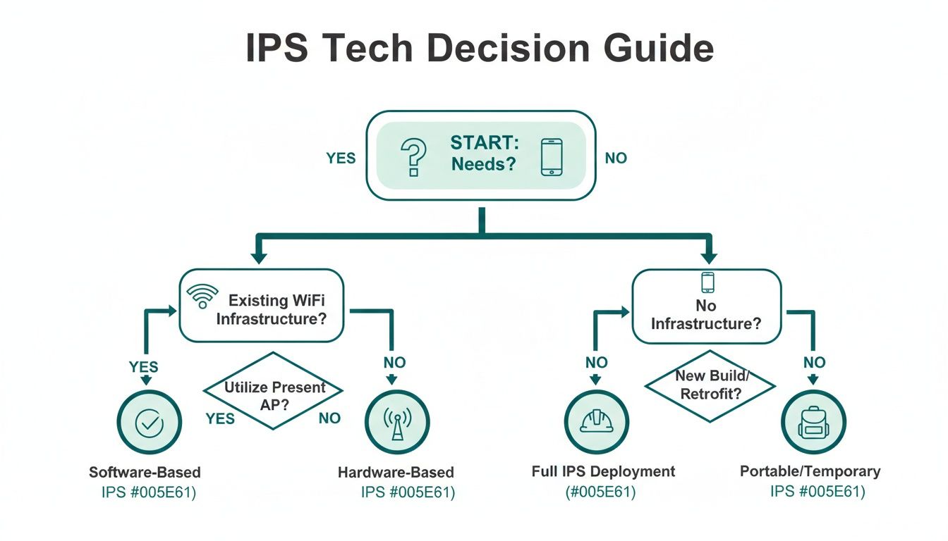
As you can see, your starting point matters. But no matter which path you take, the goal is always a reliable and scalable system that gives people the accuracy they need to navigate with confidence.
Accuracy and Reliability
Frankly, this is what matters most. An indoor positioning system that is only mostly accurate is often worse than having no system at all. In a complex public space, a few meters of error can send a passenger scrambling for the wrong platform or a patient to the wrong hospital wing.
For any large venue or transit hub, step-level accuracy of 1–3 meters is the standard. This isn't just a technical benchmark; it's what makes true accessibility possible. It provides the dependable, turn-by-turn guidance that a visually impaired person needs when they can't rely on signage.
Installation Cost and Time
The initial investment is, understandably, a huge factor for any operator. Systems that rely on physical hardware, like BLE beacons or UWB anchors, come with a significant upfront cost. You're not just buying thousands of devices; you're also paying for the specialist teams needed to install and calibrate them.
By contrast, infrastructure-free solutions that use sensor fusion on a smartphone have virtually zero hardware cost. Deployment is a world away. Instead of installing physical equipment, the main task is to create a hyper-detailed digital map of your venue. This dramatically shortens the time it takes to get your system up and running.
Choosing an indoor positioning approach is a balancing act. While low-cost hardware might seem appealing, it's vital to factor in the hidden costs of installation, maintenance, and the eventual need for replacement.
Ongoing Maintenance and Scalability
Long-term running costs are often overlooked. Every piece of hardware you install is a future point of failure that someone will have to manage.
Here’s a simple breakdown of the operational burdens involved:
- Hardware-heavy systems (e.g., BLE beacons): These demand constant attention. Batteries die. Devices get knocked off walls, moved during renovations, or simply stop working. This creates a relentless cycle of finding, replacing, and recalibrating hardware, adding a significant and permanent cost to your operations.
- Infrastructure-free systems: With no physical hardware to worry about, ongoing maintenance is practically non-existent. Updates are pushed out through software. If your building's layout changes, you simply edit the digital map – no need to send engineers out to move devices.
This difference becomes even more stark when you think about scaling up. Expanding a beacon system to a new terminal or building means going through the entire costly installation process all over again. A software-based system, on the other hand, scales by simply mapping the new area.
If you'd like to learn more, you can read our detailed comparison of indoor navigation technologies. For any large-scale deployment, this contrast in maintenance and scalability is fundamental.
Critical Factors for a Successful IPS Deployment

Choosing the right indoor positioning technology is a big decision, but it’s just the first step. The real challenge—and where most projects succeed or fail—is in the execution. This is where theory meets the reality of budgets, building layouts, and human behavior.
For anyone managing operations or a project of this scale, the focus has to shift from the technology itself to the practicalities of getting it up and running. A successful deployment isn't about flicking a switch; it's a carefully planned project.
Without clear goals and a deep understanding of your venue and users, even the most sophisticated system may go unused. Here's a practical guide to getting it right.
Define Your Objectives from Day One
Before you do anything else, you have to answer a simple question: what problem, specifically, are we trying to solve?
Vague ambitions like “improving the visitor experience” are not enough. You need concrete, measurable goals tied to real-world outcomes. This single step will guide every decision you make later, from the technology you choose to how you communicate it to the public.
Think in terms of clear, actionable objectives. For example:
- For Accessibility: A major transit authority wants to empower riders with visual impairments to navigate complex platform changes independently. The goal demands a system with 1–3 meter accuracy to be truly useful.
- For Operational Efficiency: An airport operator aims to reduce missed connections by giving passengers clear gate-to-gate directions, with a target of reducing transfer times by 15%.
- For Visitor Engagement: A sprawling shopping center wants to drive traffic to quieter retail zones, aiming for a 10% increase in footfall in those areas within six months.
Conduct a Thorough Infrastructure and Venue Assessment
With clear objectives in hand, it’s time for a reality check. You need to take a hard look at your physical space and your existing digital infrastructure. This audit will tell you what’s possible and what isn’t.
For example, if you're considering a Wi-Fi-based system, does your network actually support Wi-Fi RTT? Are your access points dense enough to deliver the accuracy you need? If not, the cost of a full network upgrade suddenly becomes part of your project budget.
A critical part of this stage is identifying "no-go" zones where signals from GPS, Wi-Fi, or mobile data are non-existent. Underground levels in a transit station or the core of a large concrete building are classic examples where only an infrastructure-free system will function reliably.
This is also the moment to assess your floor plans. Are they accurate and up-to-date? Are they available in a usable digital format? If you’re working from old blueprints, you’ll need to budget for a fresh survey to create the precise digital map that underpins any positioning system. You may also find that certain solutions are a better fit for your environment; you can learn more about the reliability and scalability of infrastructure-free solutions for wayfinding.
Plan for Seamless User Adoption
You can have the most accurate, powerful positioning system on the planet, but it’s useless if no one uses it.
It’s a classic mistake to assume, "If you build it, they will come." You need a proactive strategy to get people on board. Start by thinking about your main user groups. For a public transport network, this means daily commuters, tourists, and, crucially, travelers with disabilities. Each group needs to be reached in a way that makes sense to them.
Your adoption plan should include a few key elements:
- Clear Signage: Use physical signs at entrances and key decision points, letting people know a digital navigation tool is available to help them.
- Staff Training: Your frontline staff are your best advocates. Make sure they know how to use the system and can confidently show visitors how to get started.
- Partnerships with Community Groups: If accessibility is a core goal, work directly with disability advocacy organizations. Get their feedback early and ask them to help promote the solution to their members.
By focusing on these factors—clear goals, a thorough site audit, and a smart adoption plan—you set the stage for a deployment that actually delivers on its promise.
Building the Business Case for Indoor Positioning

Any new technology needs to earn its keep. For indoor positioning, the business case isn't just strong; it’s built on a foundation of real-world cost savings, smarter operations, and a genuine commitment to social good. This isn't about a flashy new feature—it's a strategic investment that pays dividends across your entire organization.
For most venues, the quickest return on investment (ROI) comes from the money you stop spending. Think about the endless cycle of designing, printing, and installing static signs. An indoor positioning system replaces that with a dynamic, digital layer that you can update instantly, with virtually no ongoing cost.
This simple change also gives you back your most precious resource: your staff's time. When visitors can find their own way with their phones, your team spends far less time repeating the same directions. They can then focus on what really matters, from delivering first-class customer service to enhancing security, which directly boosts productivity.
Measuring the Return on Investment
Calculating the ROI for an indoor positioning system means looking at both hard savings and operational gains. A strong business case puts these benefits into clear financial terms.
It really boils down to a few key areas:
- Reduced Signage Costs: Look at your annual budget for creating and maintaining physical signs. A digital solution all but eliminates this expense.
- Increased Staff Productivity: Estimate how much time your staff spend giving directions each day. Freeing up even a small fraction of that time for other duties represents a major operational saving.
- Improved Visitor Flow: When people can navigate easily, you reduce congestion and open up new revenue opportunities. This is especially true in retail or transit hubs, where getting people to shops and services is everything. You can read more on how IPS can benefit retail venues in our guide.
Fulfilling ESG Commitments Through Inclusive Design
Beyond the bottom line, indoor positioning systems are a powerful way to deliver on your Environmental, Social, and Governance (ESG) goals. The impact on the 'Social' aspect, in particular, is significant.
A reliable, step-accurate navigation solution is the foundation of true accessibility. For people with sight loss or other disabilities, it grants the freedom to explore complex public spaces with confidence and independence. This isn't just a "nice-to-have"; it's about providing equitable access for everyone.
By offering precise, audio-based guidance, organizations can go beyond basic compliance and become true leaders in inclusive design. This directly supports your obligations under mandates like the UK Equality Act 2010, showing a real commitment to serving every member of the community.
On top of that, your technology choice has a direct environmental impact. A hardware-free system that doesn't need thousands of beacons or other physical devices is a big win for the 'Environmental' part of ESG.
By avoiding battery-powered hardware, you cut out the electronic waste and the energy used to manufacture and maintain it. An infrastructure-free approach isn’t just more scalable and affordable—it's far more sustainable. This combination of improving social inclusion while minimizing your environmental footprint creates a powerful story for stakeholders, investors, and the public.
Your Indoor Positioning Questions, Answered
When people start looking into indoor positioning for the first time, the same few questions almost always come up. It's a complex topic, so that's perfectly normal. Let's walk through the most common ones we hear from venue operators and transport planners.
How Accurate Does It Really Need to Be?
In a sprawling airport or a busy train station, a few meters is the difference between catching your train and watching it pull away. For indoor positioning to be genuinely useful, accuracy isn’t just a nice-to-have; it's everything.
To be reliable, a system needs to deliver step-level accuracy of 1-3 meters. This is what turns a vague 'blue dot' on a map into precise guidance that can direct someone to a specific platform, ticket barrier, or even the right door on a train. Anything less is just a frustrating gimmick. This level of precision is absolutely critical for visually impaired travelers and others with disabilities, who can't rely on signage to find their way.
What's the Difference Between Positioning and Navigation?
It’s easiest to think of it like this: an indoor positioning system (IPS) is the engine that figures out exactly where you are inside a building—the "you are here" part. An indoor navigation system is the app that takes that information and gives you turn-by-turn directions to get where you're going.
You really can't have one without the other for a complete solution. The positioning system does the heavy lifting of finding your location, while the navigation system builds a route and guides you along it, usually with audio cues or a map.
Positioning finds you; navigation guides you. A successful system needs to be brilliant at both, transforming raw location data into a smooth, intuitive, and reliable journey for every single user.
Can We Really Do This Without Installing New Hardware?
Yes, absolutely. The old way of doing things involved plastering a building with battery-powered beacons or special Wi-Fi routers. Modern systems using sensor fusion don't need any of that.
These smarter solutions tap into the sensors already built into every smartphone—the accelerometer, gyroscope, and compass. By cleverly combining the data from these sensors with a detailed digital map of the venue, they can calculate a person’s position and movement with remarkable accuracy. This "infrastructure-free" approach completely removes the cost and hassle of installing and maintaining thousands of physical devices, making it possible to get up and running quickly, even across huge and complex sites.
How Do These Systems Help with Accessibility and ESG Goals?
A reliable indoor positioning system is a surprisingly powerful tool for making a real impact on your social and environmental goals. By focusing on equitable access, you create a venue that truly serves everyone in the community.
- Social Inclusion: For blind and partially sighted people who can't use physical signs, precise, hands-free audio guidance is life-changing. It empowers independent travel through intimidating spaces. This directly supports the 'Social' part of Environmental, Social, and Governance (ESG) reporting and helps you meet accessibility standards like the UK's Equality Act 2010.
- Environmental Responsibility: Opting for a hardware-free system is also a clear win for the 'Environmental' pillar. By avoiding a network of powered electronics, you massively cut down on the carbon footprint and e-waste that comes from manufacturing, shipping, and eventually disposing of thousands of devices.
It’s a dual benefit: you build a more inclusive, welcoming environment while also making solid progress on your organisation's sustainability targets.
Waymap makes the built environment truly navigable for everyone. Our precision navigation works indoors and underground without any installed hardware, delivering step-accurate audio guidance that empowers independent travel for all. Learn more about turning inclusive design into an operational advantage at https://www.waymapnav.com.
Composed with the Outrank tool