
Maps of Buildings for Accessible Indoor Wayfinding
You know the name of the clinic, office, platform or seat block you need. You're standing in the lobby, phone in hand, and the sign in front of you points left for one department and right for lifts that may not serve your floor. That gap between knowing a destination and knowing how to reach it is where maps of buildings earn their value. This guide treats them not as polished floor plans, but as live accessibility services that connect authoritative asset data, door to door routes, updates and ownership.
By Tom Pey, Founder and blind accessibility technologist.
Why Maps of Buildings Matter Indoors
A visitor arrives at an unfamiliar hospital, campus or station. She has an appointment name and a room number, but she can't tell which entrance serves that wing, whether the nearest lift reaches it, or where a corridor splits between public and staff areas.
Static signs help only if they're visible, current and placed at the exact decision point. They rarely describe points of interest along the way, such as toilets, help desks or quieter routes, and they don't warn her that the obvious corridor is stepped.

What a building map actually does
A useful building map connects places, routes and choices. It doesn't enlarge a floor plan. It lets someone decide, before and during a journey, which entrance to use, which level change to take and what to do if that path is closed.
Indoors, orientation breaks down for practical reasons. GPS signals weaken, floors overlap on a flat screen, and the same corridor name can repeat on different levels. Public access also differs from operator access, so a door that looks central on a drawing may be locked to visitors.
The scale behind that problem is large. The Office for National Statistics estimated the net capital stock of “other buildings” at approximately £1.1 trillion in 2024, within a wider £2.0 trillion category covering other buildings and structures, according to the ONS capital stocks release for 2025. That figure covers commercial, institutional, industrial and public premises that keep changing through refurbishment and change of use.
A map that only shows where a destination sits hasn't answered the visitor's real question. She still needs to know whether she can complete the journey.
That's why the starting point should be the surrounding street, not the lobby. A connected digital map guides someone to the correct entrance, through internal circulation, to an exact door or platform. For blind and low vision visitors, that guidance needs accessible audio alongside visual instructions, not a picture they're expected to interpret while moving.
How Digital Building Maps Work
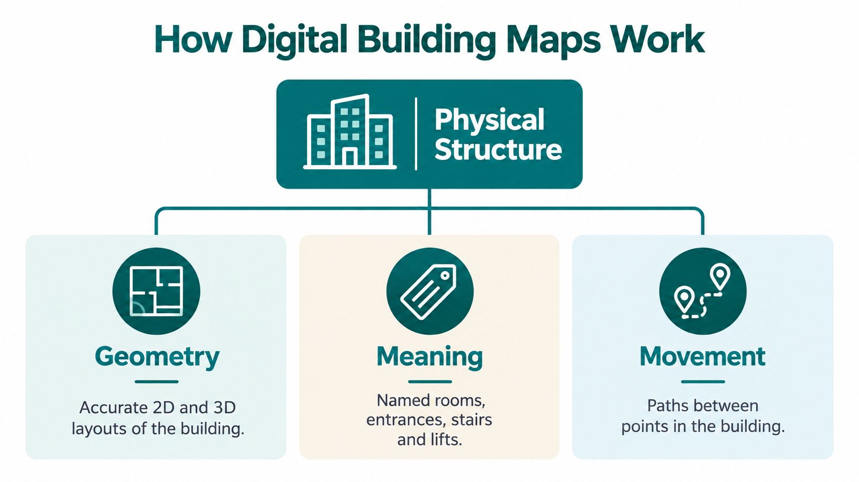
Think of a digital building map in three connected layers. Each layer answers a different question, and route guidance fails when any layer is missing.
Geometry shows shape but not meaning
Geometry is the outline. Walls, rooms, corridors, stairs and lift shafts are drawn to scale, floor by floor. On its own, geometry tells you a space exists. It doesn't tell you what that space is called today, who may enter it, or whether the door at its end is automatic.
That's the first point where readers often get confused. A visually accurate interactive floor plan can still be operationally wrong if room names, entrances and level connections haven't been checked against current use.
Meaning turns shapes into identifiable places
The semantic layer attaches machine readable identities to those shapes. Entrances, rooms, stairs, lifts, toilets, hazards and points of interest each carry attributes, such as floor, elevation relationship, opening direction and step free status. Indoor maps become searchable at this stage, because a person can ask for a named clinic rather than tap an unlabelled polygon.
UK Government BIM guidance defines BIM as a three dimensional computer model that embeds product and asset data for use across the building lifecycle, including operation and maintenance, in its building information modelling guidance. It also identifies open standards including Industry Foundation Classes (IFC) and COBie for transferring building information between systems. For a building map, that means geometry shouldn't sit in isolation from asset records.
- Stable object identifiers keep the same lift recognisable across design, facilities and wayfinding systems.
- Floor and elevation relationships prevent a route jumping between levels where no connection exists.
- Door and corridor connectivity records where a passage leads, not just where it appears to end.
Movement connects places into a route
Route logic joins those identified objects into paths a person can follow. It needs to know which passages are step free, which doors are public, how floors connect and whether a lift is currently available. Indoor positioning and digital wayfinding meet the map here, as explained in our guide to whether GPS works indoors.
A transport hub shows the difference clearly. A platform marker says Platform 4 is over there. A complete route says enter by the south entrance, cross the concourse, take Lift B, turn at the interchange corridor, then follow the platform edge to the boarding point.
Operational test: If your map can't answer what happens when Lift B closes, you have a drawing with a search box, not a maintained navigation service.
The fourth element is operational status. Temporary closures, refurbishments and changes of use alter the right answer. A maintained digital map keeps asking whether each entrance, connection and facility is still available, rather than assuming opening day conditions still apply.
Compare the Main Types of Building Maps
Operators often buy one format and expect it to do three jobs. It helps to separate orientation, browsing and guided movement before you choose.
A static plan gives a fixed view at a moment in time. It's useful for planned inspection, printed handouts and fallback reference when a phone battery dies. It can't, by itself, represent a lift outage or a visitor's preference for step free routes.
An interactive indoor map supports deliberate browsing. Someone can search for a shop, department or meeting room, zoom between floors and compare locations before moving. That suits pre visit planning, but browsing isn't the same as being guided turn by turn while carrying luggage or using a cane.
Routed digital wayfinding adds sequencing and recovery. It orders instructions, confirms progress and can offer an alternative when a corridor closes. That capability depends on maintained route data, not only on a polished interface.
| Map format | Primary user job | Operational strength | Important limitation |
|---|---|---|---|
| Static plan | Get a general sense of layout | Simple to print and inspect | Can't reflect closures or route preferences |
| Interactive indoor map | Search and browse destinations | Supports planning and floor comparison | User must still interpret movement while travelling |
| Routed wayfinding | Follow step by step guidance | Sequences turns and supports alternative routes | Needs current connectivity and status data |
Context matters outside permanent venues too. Teams comparing temporary accommodation layouts, for example, can review mobile office trailer size options to understand how a floor plan communicates space before anyone occupies it. The principle transfers directly. A layout is useful only if people can match it to their actual task.
Where formats should coexist
Don't replace a printed emergency plan with a phone interface and call that progress. Evacuation information has distinct regulatory and visibility needs, covered separately in our guide to fire safety floor plans. Printed plans, interactive browsing and routed guidance can share one maintained source while serving different moments.
The decision, then, isn't which single format wins. It's whether each format draws on the same current data, and whether someone owns updating that data when the building changes.
Make Indoor Routes Accessible Door to Door
Showing a wheelchair symbol beside a lift doesn't prove a journey is accessible. That assumption is the most common failure in building maps, and it's worth challenging directly.
Points are not routes
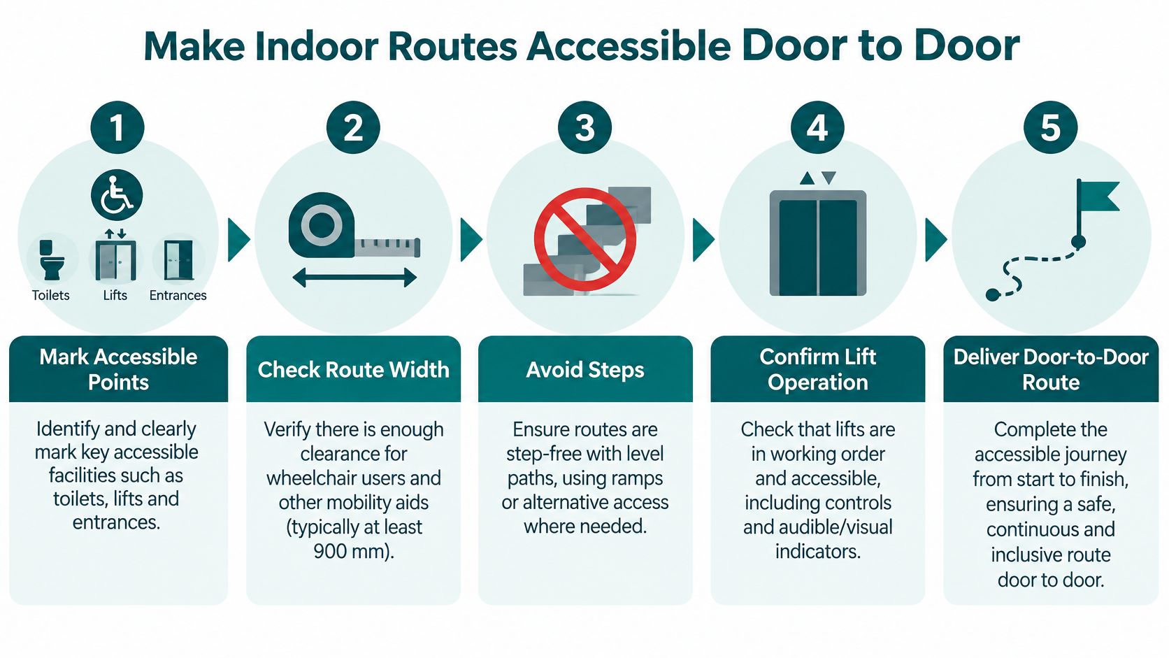
A map can mark an accessible toilet, entrance and lift accurately and still leave a gap between them. The route may include a narrow passage, a heavy door, a surface change, a confusing interchange or a temporary obstruction. If any link fails, the destination might as well not be marked.
National Centre for Accessible Transport research reports that 92% of disabled people encounter barriers when using at least one transport mode, and disabled people make 38% fewer journeys than non disabled people, in its Joined up policies, Joined up journeys highlights report. Those figures explain why confidence matters before someone sets out, not only after they arrive.
Ask route level questions instead.
- Can I enter here today and reach the intended destination without backtracking to another door?
- What changes on the way in level, surface, width, lighting or crowding?
- What's the alternative if the obvious lift, entrance or corridor is unavailable?
Legal duties set a floor, not a ceiling
Part M of the Building Regulations 2010 sets minimum requirements so a broad range of people can access and use buildings, but Government guidance states compliance with Part M does not prove compliance with the Equality Act 2010, in its Building Regulations and Equality Act clarification. The Equality Act requires reasonable adjustments for the specific needs of likely users. A technically compliant building can still disadvantage visitors if they can't obtain usable information about navigating it.
GOV.UK guidance on reasonable adjustments covers changes to operations, changes to the built environment, and auxiliary aids including accessible information, and states disabled customers must not be charged for reasonable adjustments, in reasonable adjustments as a legal duty. Our overview of UK accessibility standards sets those duties alongside related standards such as BS 8300 and BS EN 17210.
The short video below illustrates how audio guidance supports movement through a venue when visual signs alone aren't enough.
Accessible information should work in more than one format. Audio, visual and structured text support different access needs, including blind, low vision, neurodivergent, older and mobility impaired visitors. A detailed indoor map supports those duties. It doesn't replace fixing a physical barrier.
Create Indoor Maps from Authoritative Information
Start with journeys, not drawings. If you begin by tracing every wall, you'll produce detail nobody asked for and miss the connections visitors depend on.
Define the journeys that matter first
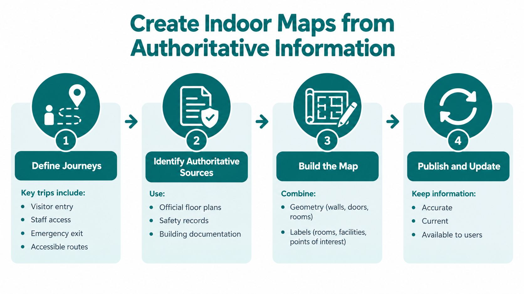
List the trips your map must support. Typical examples include street to reception, entrance to platform, car park to clinic, and seat to accessible toilet and back. Each journey names its start, destination, level changes and decision points, which then tells you what data you need.
Historic precedent reinforces why provenance matters. Historic England reports Ordnance Survey maps from the 1840s onward can trace development, and the 1910 Valuation Office survey mapped every property in the country, in its historic environment assessment guidance. A modern building may sit on an earlier footprint, so dated, versioned records prevent old entrances and plots being mistaken for current ones.
Identify authoritative sources and owners
Next, find who holds trusted geometry and asset records. That may be estates, a design team, facilities management or a capital projects group. Capture can involve existing plans and survey methods such as those described in our article on 3D LiDAR scanning, but capture method matters less than agreement on which record is authoritative.
The UK BIM Framework implements the ISO 19650 information management approach, and the Government education estates model aligns data with BIM, IFC, ISO 19650, the Government Property Data Standard and Uniclass, in the education estates property data model. Applied to building maps, that supports three layers with separate ownership. A geometric base, a semantic layer for spaces and assets, and an operational layer for closures, hazards and service status.
Specialist environments show why independent checking matters. A Labs USA floor plan review illustrates the kind of structured scrutiny applied before a laboratory layout is approved, checking whether drawn space matches intended function. Visitor maps need equivalent discipline for public routes and restricted zones.
Build, validate and publish as separate steps
Build the map by assigning stable identifiers, explicit floor relationships and door and corridor connectivity. Add accessible route attributes and points of interest, including entrances, lifts, ramps, toilets, assistance points and service areas.
Then validate each layer independently before publication.
- Walk the route and confirm every instructed turn exists and is publicly accessible.
- Check level changes by travelling them, rather than trusting a lift symbol.
- Test failure cases by removing one entrance or lift and confirming an alternative route is offered.
- Record the version, update date and owner for every change.
Don't publish a route you haven't travelled. Drawings describe intent. Walking the route describes experience.
Handover needs the same care. When capital works finish, operations should receive the maintained information model, not a single exported image. Temporary construction routes must expire on a known date so they don't conflict with permanent instructions.
See How Complex Venues Use Indoor Navigation
The same map specification produces different pressures in different venues. What matters is which journey breaks first when detail is missing.
Transport interchanges need route level precision
Transport for London reported that, as of 2025, 93 London Underground stations had step free access, more than 60 London Overground stations were step free, and all 41 Elizabeth line stations were step free, on its step free access page. A station can therefore be described as step free while a particular entrance, interchange or exit isn't.
National rail data sharpens that distinction. The Department for Transport states approximately 56% of stations and around 66% of the 1.3 billion journeys have step free access to platforms, while level boarding is available at only 4% of stations, in its roadmap to an accessible railway. Step free access to a platform doesn't necessarily mean independent street to seat travel. A station map should separate those concepts and show lifts, ramps, subway or bridge transfers, boarding points and assistance locations.
Operators such as WMATA and SBS Transit illustrate the operational context for Waymap, whose platform fuses smartphone motion sensors with detailed maps to provide dead reckoning guidance indoors, outdoors and underground without GPS, Wi-Fi or installed hardware, delivered as heads up, hands free audio. For a transport operator, avoiding installed hardware removes a maintenance burden across high footfall, high change stations where beacons need power, inspection and replacement.
Venues, campuses and retail sites start outside the door
At a large venue such as Lord's, visitors need routes to seats, amenities and exits, but their journey begins at a station, bus stop or street gate. Audio and on screen instructions should continue across that threshold rather than restart at reception.
Campuses present a similar boundary problem. A university map that stops at each building outline forces students to stitch together separate journeys, which our guide to campus wayfinding addresses directly. Shopping centres and public buildings need the same continuity between site map, entrances and internal destinations.
Directory style listings show the limits of location information on its own. A Pickleballer venue directory can tell a visitor which floor a court occupies inside a mall, but it can't guide them from the mall entrance to that court. That last stretch is exactly where building maps must take over.
Maintain Accurate Indoor Maps After Opening
Opening day is when a map starts ageing. Tenants move, clinics relocate, event layouts appear overnight, and a lift that worked on Monday is fenced off on Wednesday.
Facilities and transport teams face specific friction. Staff turnover erodes local knowledge, capital approval cycles delay hardware projects, and installed equipment becomes another asset to inspect and repair. NHS estates managers, for example, must fit wayfinding improvements around capital spend restrictions and live clinical operations. A map process that depends on scarce specialists or physical kit will stall.
Assign ownership by layer
Name an owner for each part of the system.
- Geometry owner approves wall, door and floor changes from estates or capital works.
- Semantic owner controls room names, points of interest and restricted areas.
- Operational owner updates closures, lift outages, relocated entrances and event layouts.
Each change needs version history, a date and approval. Temporary closures should sit in the operational layer so they don't overwrite authoritative asset data. When the closure ends, the original route returns without anyone redrawing the base map.
Validate with feedback and audits
Staff reports and user feedback expose broken links and ambiguous instructions quickly, but they shouldn't be your only check. Schedule route audits after refurbishments, tenant changes and accessibility works. Travel priority journeys in full, including the alternative route you'd offer during a lift outage.
Governance rule: Every published route should have a named owner, a last travelled date and a tested alternative.
Finally, measure outcomes, not downloads. The National Travel Survey reports 32% of disabled adults lived in households without car access in 2025, compared with 16% of non disabled adults, in National Travel Survey disability statistics. For people who depend on public venues and transport, deciding whether an unfamiliar journey is predictable enough to attempt is the true test. Track completed journeys, assistance requests, missed connections, late arrivals and repeat visits alongside map usage, without claiming the map alone caused every change.
An infrastructure free, updateable map suits this discipline because changes are data updates, not hardware visits. That keeps the focus where it belongs, on whether visitors can still complete the journey today.
Frequently Asked Questions About Building Maps
What is a digital building map
A digital building map is a structured model of a building's geometry, named spaces and routes between them. Unlike a picture, it carries machine readable information about entrances, lifts and level changes so guidance can respond when conditions change.
How do maps of buildings differ from floor plans
Maps of buildings differ from floor plans because they connect destinations into navigable routes across floors and entrances. A floor plan shows layout at one level, while a building map adds identity, connectivity and operational status.
What should an organisation check when choosing a system
An organisation should first check who owns the underlying data and how updates are approved and published. Then test whether routes remain complete when a lift or entrance closes, and whether guidance works in audio and visual formats without new installed hardware.
What happens when an accessible route changes
When an accessible route changes, the operational layer should be updated immediately and an alternative route offered. The underlying asset record stays intact, the change is dated, and the replacement route should be travelled and validated before visitors rely on it.
If your building map still stops at a floor plan, talk to Waymap about turning it into a maintained, accessible navigation service that guides visitors from street to exact destination without GPS, Wi-Fi or installed hardware. Our team works with transport operators, venues, campuses and public estates to build maps that stay current as layouts change. Visit us to discuss a route audit for your site and see what door to door guidance would look like for your visitors.
