
Campus Wayfinding That Actually Works: A 2026 Guide
The default advice on campus wayfinding is usually backwards. It starts with signs, then adds a map, then maybe an app, as if people move through campus one panel at a time. In practice, the problem is the full journey, from the bus stop or car park, through gateways, lifts, corridors, temporary closures and the final room entrance.
That matters because movement alone doesn't make a campus easier to move through. The University of Surrey's travel survey shows that many staff and students already walk or wheel between campuses, yet traffic, delays, roadworks and unreliable transport still make journeys difficult, with safety concerns also tied to lighting, crossings and CCTV. If a campus expects people to walk more, it still has to solve the route, the handoff points and the changes in the environment, not just the distance.
A useful lens is to treat campus navigation as an operating system for arrival, orientation and destination confirmation. For a quick external reference on how estates teams think about visible deterrents and regulated notices, find CCTV signage compliance tips can help when signage is part of a broader site review. The bigger point is simpler: a campus that is easy to cross is not necessarily easy to understand.
Why Campus Wayfinding Is Not Really About Signs
Most campus teams begin with what they can see, signs, directories and map boards. That's understandable, because those are the visible artefacts of navigation. But the visible layer only works when the invisible layer underneath is already organised.
The journey is the unit that matters
Imperial College London defines wayfinding as a combination of architectural, visual, written and verbal cues, and says the journey needs consistent appearance, tone of voice and content hierarchy from home to destination and back again. That framing is more useful than a sign audit because it forces estates teams to think in transitions, not objects. A sign that looks clear in isolation can still fail if it arrives too late, uses the wrong destination name, or contradicts what the visitor saw at the last decision point.
The University of Sheffield's strategy makes the same underlying point by prioritising pre-visit information, gateways, orientation points, public-space identifiers, entrances and car parks. In other words, wayfinding performance depends on continuity across digital and physical touchpoints, not on whether one sign happens to be visible.
A better question is not “Are there enough signs?” It's “Can someone stay confident as they move from transport to entrance to interior space?”
Practical rule: if a visitor has to stop and re-interpret the campus at every handoff, the system is broken, even when every individual sign is technically correct.
That's why static guidance is often the wrong fix for a dynamic site. A lecture room moves, an entrance closes, a lift fails, a shuttle stop changes, and the old instructions remain in circulation. A useful operational model has to absorb those changes before people feel them.
What Campus Wayfinding Actually Means
Campus wayfinding covers the full set of architectural, visual, written, and verbal cues that helps someone move from where they are to a specific room, then back again. Imperial College London's definition is useful because it treats appearance, tone, and content hierarchy as one system. Read a practical overview of what wayfinding means if you want the wider discipline behind the term.
Four layers have to hand off cleanly
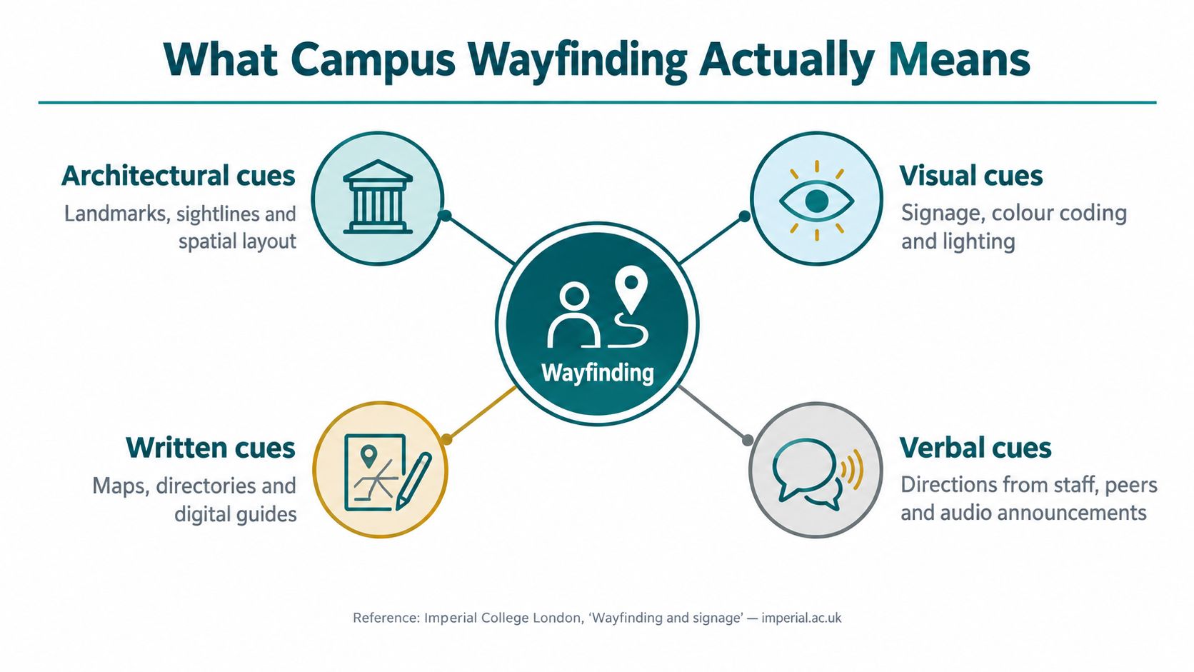
Campus navigation only works when each layer gives the next one enough context. Outside, people need routing from transport and parking to the correct side of the estate. At gateways and orientation points, they need confirmation that they have reached the right zone. Inside the building, they need directional and positional cues through lifts, stairs, and corridors. At the destination itself, they need the exact room, floor, and accessible facilities.
Glasgow shows why that last layer matters. Its room-finder and desktop navigation service gives directions between buildings and to specific rooms, while the Gilmorehill map also lets users search for public toilets and disabled parking bays and view room locations on particular floors. The point is not the map view on its own. It is the room-name taxonomy that stays aligned across departments, so the same destination label means the same thing in every part of the system.
A map shows the campus shape. A system tells you what to do next, and it stays truthful when the route changes.
Operational insight: a single destination taxonomy matters more than a pile of content widgets. If every team names buildings differently, navigation will drift even when the interface looks polished.
That is why static guidance breaks down on active campuses. A lecture room changes. An entrance closes. A lift fails. A shuttle stop moves. The useful model absorbs those changes before visitors feel them, so the journey still makes sense when the ground shifts.
The Technologies Powering Indoor and Outdoor Navigation
Outdoor campus routing is the easy part. GPS and mapping APIs can get visitors to the right side of the estate quickly enough, especially on open streets and clear pedestrian networks. The trouble starts when the journey moves indoors, underground or through places where signal quality drops and layouts change often.
Each technology solves a different part of the trip
WiFi fingerprinting can work indoors, but it drifts when routers move or the environment changes. Bluetooth beacons can improve proximity detection, but they need physical installation, power and ongoing maintenance. QR codes help at decision points, but they don't guide someone between those points, which is where most confusion happens.
That's why sensor fusion and dead reckoning matter. A system that uses the phone's motion sensors, together with a good map model, can keep guidance going where GPS and WiFi become unreliable. Waymap's own approach uses device-native motion sensors to deliver guidance indoors, outdoors and underground without GPS, WiFi or installed hardware, which is why it fits complex campuses with mixed environments and frequent change.
The trade-off is never one-dimensional. More installed infrastructure can mean more maintenance. More software dependence can mean more reliance on map quality and update discipline. The right stack depends on the site, not on a vendor's favourite architecture.
If you want a broader primer on how location technologies are chosen, the location based service tech guide is useful context when teams compare GPS, proximity systems and app-based routing. On campus, the practical rule is blunt: use the tool that survives the environment you have.
The internal guide to indoor location tracking gives a useful technical frame for the indoor portion of the journey. For estates teams, the main question isn't which technology sounds clever, it's which one keeps working when the building changes.
Accessibility as the Decisive Driver for Campus Wayfinding
Accessibility sits at the center of campus navigation, and the standards make that clear. The Equality Act 2010 places a duty on universities as service providers to make reasonable adjustments. BS 8300 covers accessible building design, including information hierarchy, contrast, illumination and sign positioning. BS EN 17210 addresses accessibility of the built environment, and PAS 78 supports inclusive pedestrian environments.
The business case is really a participation case
The clearest sign that campus wayfinding still fails people comes from the 2023 Disabled Students' Access Insights report. It found that only 36% of students with mobility disabilities considered their campus accessible, 40% regarded it as inaccessible, and 48% lacked confidence that they could evacuate buildings in an emergency. Those figures point to route usability, entrance clarity and confidence in leaving the building safely, not just to sign design.
Accessibility has to be built into the journey model from the start. The University of Sheffield's guidance warns against redundant information, over-signing, blocked sightlines and signs placed in walkways. The University of the West of England combines physical signage, electronic signage, apps and online mapping, while requiring accessible routes to appear on signage diagrams and identifying tactile or raised symbols for toilets and other major spaces.
For campus teams, that creates a real trade-off. Beacon-heavy systems can require capital spend and ongoing maintenance, which makes them awkward when the immediate need is usable access rather than a hardware rollout. Infrastructure-free navigation avoids part of that burden, because it can be deployed and updated like other institutional software, without waiting for works programmes.
A good accessibility programme also depends on operational discipline. Temporary closures, lift outages and changes to entrances need to flow into the route model quickly, or the campus may look compliant on paper while still failing people in practice. That is why accessibility best practices should sit alongside route design and signage decisions.
Compliance is only the starting line; the measure of success is a visitor who reaches the exact entrance, uses a usable route and leaves the building with confidence.
How Universities Implement a Modern Wayfinding System
A usable campus system starts with governance, not graphics. The first job is to define a single destination taxonomy and a route database that every channel shares. Imperial and Sheffield both point toward the same operating model, stable identifiers, auditable updates and consistent terminology across maps, signs and audio guidance.
Build one source of truth
The route database should hold every destination name, every confirmed entrance and every route instruction that might change when a building, door or pedestrian link changes. That sounds tedious because it is tedious, but it's the difference between navigation that ages well and navigation that goes stale in six months.
UWE Bristol's model adds a second discipline: model accessible routes separately from nominal shortest paths. That means recording gradients, stairs, lifts, door widths, surface conditions and temporary closures rather than assuming the shortest route is the best one. It also means route instructions can change when a lift fails or a path closes without rewriting the whole campus map.
A practical governance setup usually includes estates for route ownership, digital teams for publishing, and accessibility leads for route validation. Change control should be tight, because the failure mode is not cosmetic, it's someone being sent to a closed entrance or an unusable path.
The internal article on interactive campus maps is relevant here because the interface is only as good as the data behind it. The test regime matters just as much. Sheffield's strategy points to blind and low-vision users, wheelchair users and visitors unfamiliar with the estate, with success measured by route completion, deviation count, avoidable barriers and arrival at the exact entrance.
Testing rule: don't ask whether people found the right building. Ask whether they arrived at the right door without help.
That distinction changes the whole programme. A campus wayfinding system is not a product you buy and forget. It's an operating model you maintain.
Named Deployments That Show the Model in Practice
University navigation becomes clearer when you look at institutions that have connected destination data, route continuity, and accessible presentation in one system.
Three deployments, three useful lessons
The University of Glasgow links its room-finder and interactive Gilmorehill map with AccessAble coverage for more than 100 university services and buildings across three campuses. That gives visitors a practical layer of detail once they move beyond the outer edge of campus and need to find the right place, not just the right building.
The University of the West of England uses a multi-strand model with physical totems, electronic signage and wayfinding apps. Its approach keeps those layers aligned, so the same destination information appears consistently across screens, signs and mobile guidance. Digital wayfinding does not replace physical information, it works alongside it.
Waymap's deployment at Lord's Cricket Ground extends the same logic beyond higher education. It was the first stadium deployment of Waymap, and it supports full journey routing for fans, staff and disabled visitors from anywhere within the M25. The lesson for campus teams is direct, a single infrastructure-free navigation layer can serve very different venues if the destination data is disciplined.
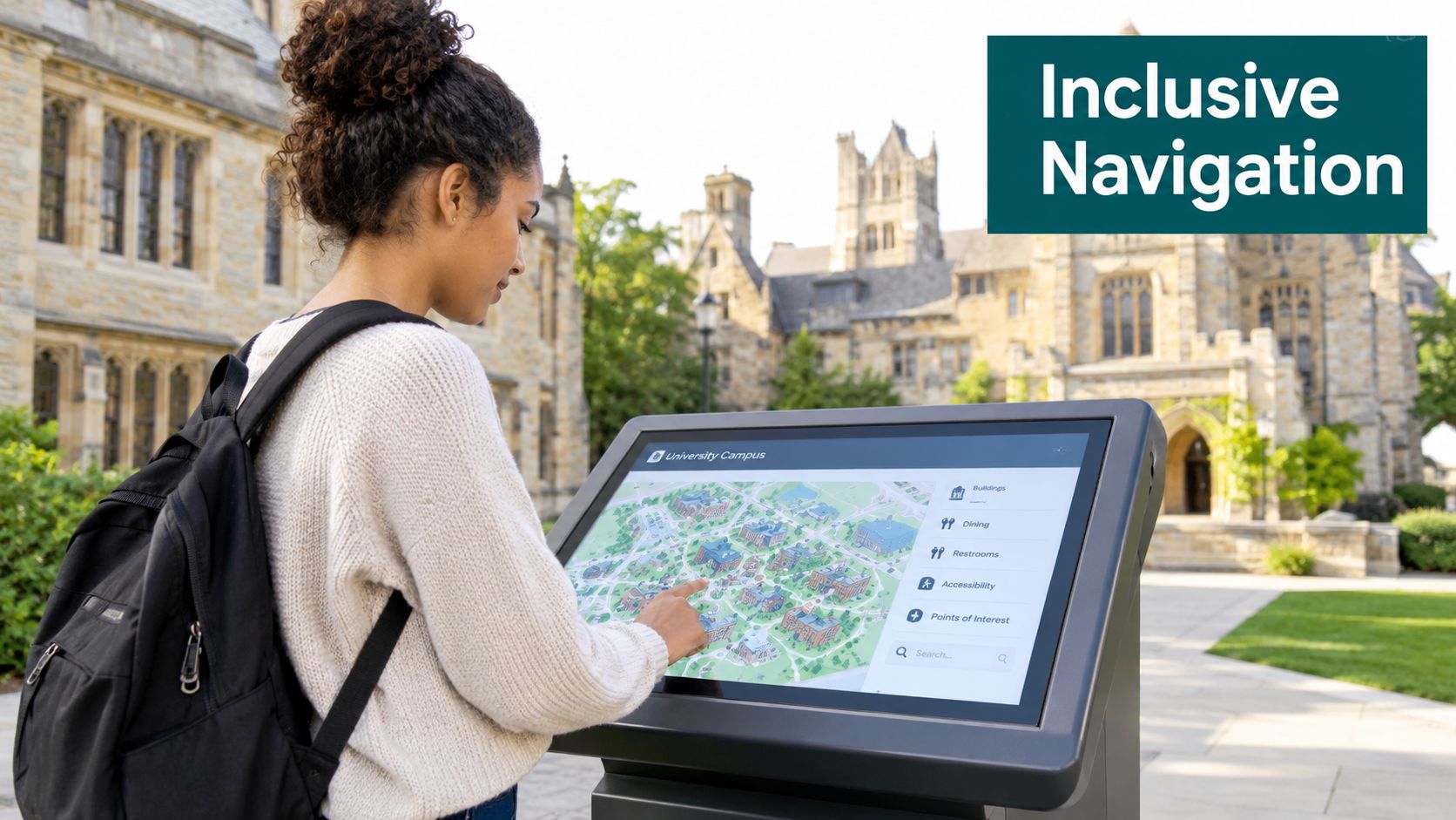
What these examples share matters more than what sets them apart. Each one treats the destination as the unit of truth, not the sign, the screen or the app. That is why vague “smart campus” claims usually fall short. They describe the interface, but not the journey.
ROI and KPIs for Campus Wayfinding Investments
The business case for campus navigation gets muddled when teams talk only about “student experience.” Estates directors, pro-vice-chancellors for student experience and sustainability leads need something more concrete. They need measures that reflect operating cost, route quality and compliance.
Measure completion, not installs
The most obvious financial argument is capital cost avoidance. If a programme avoids beacon hardware, cabling and power work, it also avoids the maintenance load that comes with installed infrastructure. That matters in universities, where capital cycles are often tight and every fixed asset competes with other estates priorities.
The operational measures are clearer still. Useful metrics include first-attempt destination success, wrong-turn frequency, time-to-destination, requests for staff assistance and accessibility-route completion rate, all segmented by visitor type and time of day. Those figures tell you whether the system is reducing friction, not whether people downloaded an app once.
The risk is measuring the wrong thing. App downloads are vanity data. Floor-plan views are interesting but not decisive. What matters is whether a first-time visitor reaches the exact entrance on the first try, or whether a disabled visitor can complete the accessible route without backtracking.
The internal guide on how to measure cost savings is a helpful companion if you're building a business case for finance or estates committees. For most universities, the strongest ROI signal is not a flashy percentage, it's fewer escalations, fewer missed starts and less staff time spent giving directions.
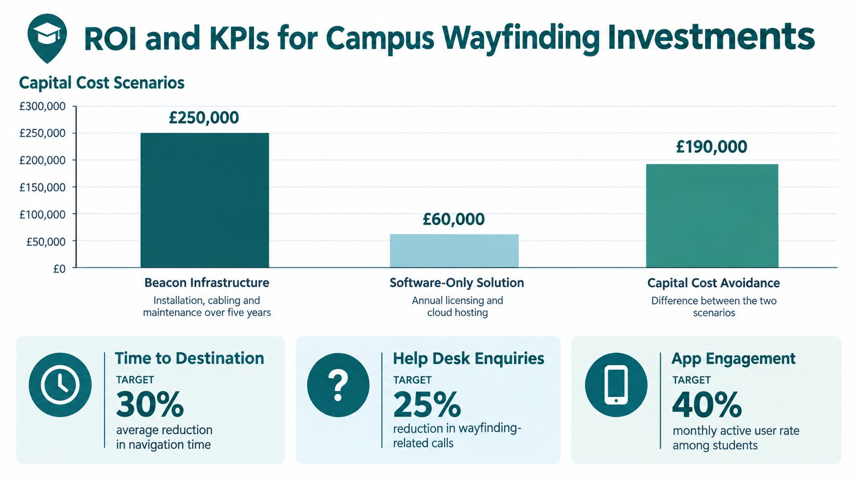
Practical KPI set: track functional completion first, then add help requests, detours and arrival confidence. If a metric doesn't change behaviour, it won't change the programme.
Putting It Together and Answering Common Questions
A workable 90-day approach is straightforward. Audit the current signs, maps and apps. Define one destination taxonomy. Model accessible routes separately. Run a baseline measurement week. Pick one building or one journey for proof of value. Then set governance so changes get reflected everywhere they need to appear.
FAQ
Is beacon-free navigation better than beacons?
Beacon-free navigation avoids the install, power and maintenance burden of physical hardware, which makes it easier to manage across changing buildings and high-footfall sites. Beacons can still work in some estates, but they introduce an infrastructure commitment that many campuses don't need.
How quickly can ROI show up?
ROI usually becomes visible once the system is live and route data is being updated consistently, often within one academic cycle of full deployment. The signal is operational, fewer staff interruptions, fewer wrong turns and better route completion.
How is BS 8300 different from PAS 78?
BS 8300 focuses on accessible building design and information controls. PAS 78 is about inclusive pedestrian routes and the journey between places, which is why both matter for campus wayfinding.
If you're planning a campus navigation upgrade, the right first move is to map the full journey, not just the building footprints. Waymap supports indoor, outdoor and underground navigation, which makes it relevant when your campus needs exact-door guidance, accessible routing and a system that can change as the estate changes. To see how that works across universities and venues, visit Waymap.
