
10 Accessibility Best Practices for Built and Digital Spaces
You arrive at a busy transit hub with a clear destination. The signs are difficult to read, the lift is out of service, and refurbishment has changed the corridor. An accessible journey should still provide precise directions, identify the correct entrance or platform, locate an accessible facility, and communicate disruptions without relying on chance or repeated staff assistance.
That requires more than compliant signage or a website audit. Accessibility best practices connect physical wayfinding, digital services, operational data, user testing, and staff processes. Disabled people are a substantial part of the population. Around 16.1 million people in the UK are disabled. Disabled adults in England made an average of 740 trips per person in 2023/24, compared with 989 trips for non-disabled adults, a gap documented in official UK transport accessibility statistics.
Waymap's work with WMATA, Westfield London, and SBS Transit shows how operators can connect accessible information with practical wayfinding across complex sites. The practices below focus on what public transport agencies, hospitals, shopping centres, universities, stadiums, offices, airports, libraries, theatres, and public services can implement, maintain, test, and measure. They address the everyday barriers faced by visitors, while supporting operational teams responsible for accurate routes and service information.
1. Implement infrastructure-free indoor navigation for all visitors
Indoor navigation fails when it depends on infrastructure that is expensive to install and difficult to maintain. Bluetooth beacons, Wi-Fi positioning equipment, and GPS repeaters can create another estate-management burden, particularly across underground stations, large campuses, hospitals, and shopping centres with changing layouts.
Waymap takes a different approach. Its navigation algorithm uses device-native motion sensors and detailed maps, rather than GPS, Wi-Fi, or installed hardware. That enables guidance indoors, outdoors, and underground, including signal-poor environments. The system uses dead reckoning to estimate movement and provide precise directions to doors, platforms, and points of interest.
The operational advantage is clear. Estates teams maintain the map and venue information instead of replacing batteries, inspecting beacon coverage, or tracking hardware failures across a large site. Waymap has worked with named environments including WMATA, Westfield London, and SBS Transit, addressing the practical challenge of guiding people through complex transport and venue spaces without relying on physical signal infrastructure.

Make the map a governed operational asset
Technology won't compensate for an incomplete map. Before launch, map entrances, doors, corridors, lifts, stairs, platforms, toilets, service desks, seating areas, and temporary restrictions. Give a named estates or operations owner responsibility for updates, and create a simple staff process for reporting layout changes.
Teams should also:
- Test route completeness: Confirm that directions reach the exact destination, not merely the correct building.
- Review change control: Connect refurbishment, maintenance, and event-planning workflows to map updates.
- Test with disabled users: Blind and low-vision participants can identify dead zones and ambiguous landmarks that a desktop review misses.
- Use operational feedback: Search activity, failed routes, and repeated help requests can reveal bottlenecks requiring better mapping.
For background on navigation in places where GPS is unavailable, see Waymap's explanation of GPS-denied navigation.
Practical rule: Treat map accuracy as part of accessibility governance, not as a one-off technology task.
2. Provide audio-first navigation for blind and low-vision users
A screen can support navigation, but it shouldn't be the only interface. People who are blind or have low vision need guidance that works while they're walking, handling a cane, listening for environmental cues, or moving through a crowded corridor. Audio-first navigation makes instructions available through a phone speaker or headphones without requiring continuous visual attention.
Effective audio guidance is specific and timely. “Continue through the building” leaves too much interpretation to the user. “Turn left after the reception desk, then continue to the lift” identifies an action and a landmark. Waymap's hands-free audio instructions are designed around this principle, adapting to a person's walking style by learning movement patterns, stride, and pace.
This approach is relevant across different environments. At the Royal Hospital for Children and Young People, audio navigation can help patients and families orient themselves in an unfamiliar healthcare setting. In Westfield London, multilingual audio guidance supports visitors moving through a large retail environment. In underground transfer corridors such as those served by WMATA, adaptive instructions can help users manage complex changes in direction.
Test the language as carefully as the route
Audio design needs its own standards. Decide how the system names landmarks, how often it repeats instructions, and how it handles a user who stops, turns around, or moves away from the route. Offer controls for instruction frequency, pace, tone, and audio output.
Use short, action-led phrases and test them during busy periods, not only in an empty building. Invite blind and low-vision users into early design sessions, then continue testing after launch. The Waymap approach to products for vision-impaired users provides a useful reference for designing navigation around independence rather than screen interaction.
Audio isn't a substitute for visual information. Provide clear visual maps, high contrast, captions, transcripts, and compatible digital content so users can choose the format that works for them. For guidance on describing images in digital content, see Wispra's alt text optimisation strategies.
3. Design dynamic, updateable points of interest instead of static signage
Static signage tells users what was true when someone printed and installed it. Large venues rarely stay that way. Shops move, clinics change departments, lifts close for maintenance, temporary entrances open, and event layouts alter circulation.
A digital points-of-interest layer lets venue managers update this information without replacing every sign or asking users to rely on outdated maps. The important detail is location-level precision. A system should identify the accessible entrance, the specific lift, the toilet on the relevant floor, or the temporary service desk, rather than making a broad claim that a venue is accessible.
Waymap's dynamic wayfinding layer allows operators to add, remove, and reposition points of interest. In a large environment such as Westfield London, that capability supports changing retail locations and closures. For WMATA, accessibility-related points of interest can be maintained across a station network without creating a printing cycle. SBS Transit demonstrates the relevance of live facility information in a multilingual, underground and above-ground transport context.
Connect updates to everyday operations
The technology should fit the way teams already work. Facilities managers, security staff, station teams, retailers, and event contractors need a clear route for reporting changes. A map administrator then verifies the information and publishes it through the approved process.
Prioritise:
- Accessibility-critical locations: Lifts, step-free entrances, accessible toilets, hearing loops, quiet rooms, and assistance points should receive early attention.
- Temporary conditions: Record closures, diversions, maintenance windows, and alternative routes.
- Search failures: Review locations users frequently search for but fail to find.
- Routine verification: Schedule regular reviews and require confirmation from the team responsible for each area.
- Staff contribution: Frontline employees often notice changes before central estates teams do.
Waymap's dynamic map functionality illustrates why updateable wayfinding is more useful than a fixed accessibility statement. A current route supports action. An outdated sign creates uncertainty.
4. Conduct accessibility testing with disabled users, not just compliance audits
Compliance audits identify known requirements. They don't always reveal whether a person can complete a real journey independently. A route may satisfy a design specification yet fail because a landmark is ambiguous, an announcement comes too late, a diversion is poorly communicated, or a lift entrance is difficult to locate.
Test with disabled people in the actual environment. Include blind and low-vision users, deaf and hard-of-hearing users, deaf-blind users, people with mobility disabilities, people with cognitive disabilities, and neurodivergent users. Each group can expose a different failure mode.
The Royal Hospital for Children and Young People provides a relevant context because children, families, and visitors may need to find their way around an unfamiliar and emotionally demanding setting. A shopping centre such as Westfield London must account for long routes, noise, crowds, and changing retail layouts. Transport operators such as WMATA need to validate complex transfers with people who use stations regularly, not just with staff who know the infrastructure intimately.
Test journeys, not isolated features
Give participants realistic tasks. Ask them to enter from an accessible arrival point, find a particular destination, respond to a closure, locate a toilet, or change floors. Observe where they hesitate, ask for assistance, deviate from the route, or lose confidence.
A robust programme should:
- Recruit through advocacy organisations: This improves reach and helps build trust.
- Pay participants fairly: Disabled people contribute specialist expertise and lived experience.
- Test at different times: Peak periods expose crowding, sound, queues, and staff availability.
- Record findings transparently: Document what changed because of user feedback.
- Repeat after launch: New construction, events, and operational changes can introduce fresh barriers.
Use automated checks and formal audits for what they do well, but don't treat either as a substitute for lived-experience testing. Waymap's overview of accessibility testing reflects this user-centred approach. Digital teams can also use guidance on web accessibility standards as part of the wider assurance process.
5. Map accessibility attributes alongside physical navigation
Reaching the right building doesn't guarantee a route is accessible. Users need to know whether the entrance is step-free, whether a lift is available, where an accessible toilet is located, and whether a facility is temporarily closed.
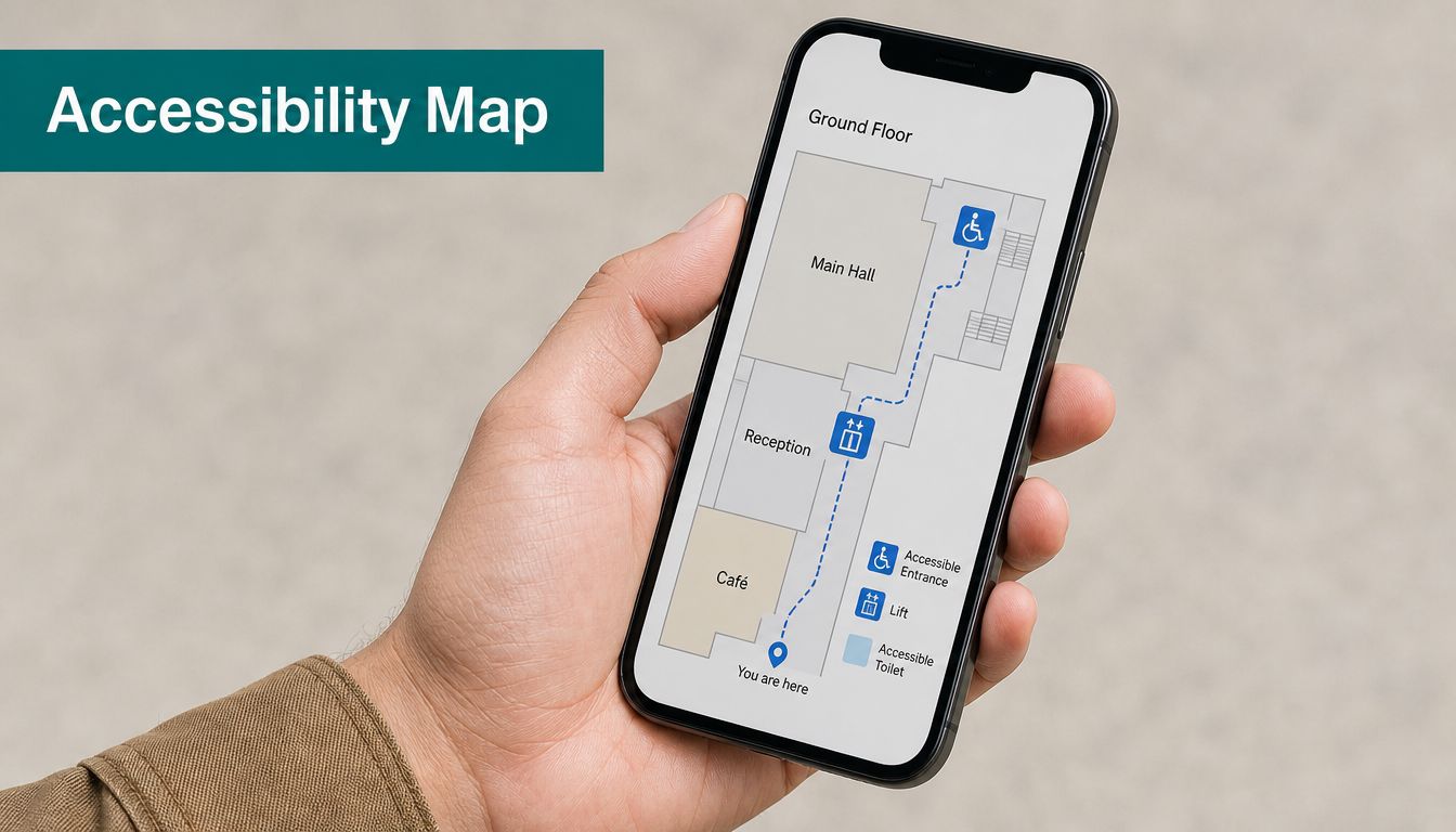
Map these details as attributes attached to precise locations. A venue-level label such as “wheelchair accessible” doesn't answer the questions a visitor needs to make a journey. The useful information is more granular: step-free entrance at the west side, lift beside a named corridor, accessible toilet on a particular floor, hearing loop at a service desk, quiet space near a waiting area, or accessible parking connected to a specific entrance.
Waymap supports accessible points of interest and step-free routing, allowing operators to connect facility information to navigation. In Westfield London, this can mean mapping accessible entrances, lifts, and toilets across a large retail centre. In a station network such as WMATA, users need accessibility information connected to the individual station and route. For SBS Transit, accessibility attributes can support journeys that combine underground and surface environments.
Start with the attributes users actually need
Don't begin by copying a generic database of features. Ask disabled users which information affects their decisions and confidence. Then audit each attribute before publishing it.
Include:
- Access conditions: Step-free entrances, ramps, lifts, and door widths where relevant.
- Facilities: Accessible toilets, seating, hearing loops, quiet spaces, and assistance points.
- Parking and arrival: Blue Badge parking, drop-off points, and the step-free route from arrival.
- Live status: Closures, maintenance, queues, and alternative facilities.
- Search terms: Use language visitors will enter into an app or speak aloud.
The Waymap guidance on mapping show and venue information demonstrates the importance of mapping the destination and its access details together. Assign ownership, audit the data regularly, and make the update process as visible as the route itself.
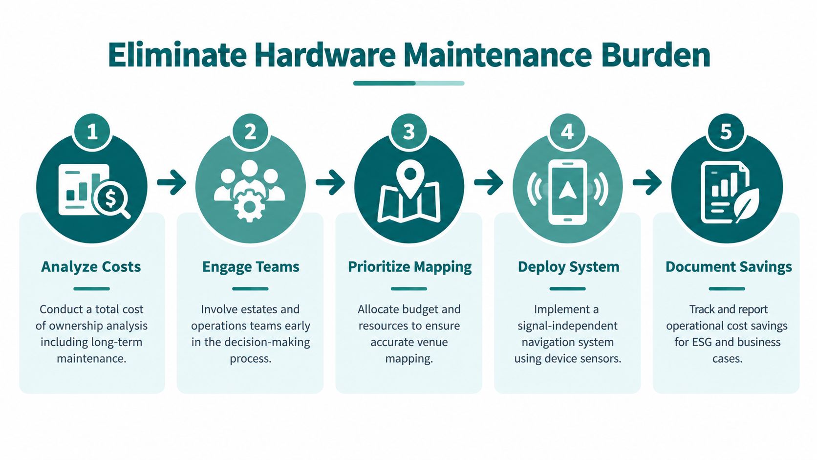
6. Eliminate hardware maintenance burden by choosing signal-independent systems
A navigation project can look affordable at launch and become difficult later. Physical infrastructure needs installation records, access permissions, battery checks, replacement schedules, firmware management, and coverage testing. In a high-footfall venue, hardware can also be moved, damaged, or obscured by refurbishment.
Signal-independent systems avoid that maintenance model. Waymap uses a smartphone's native motion sensors with detailed maps, so operators don't need to install Bluetooth beacons, Wi-Fi positioning equipment, or GPS repeaters throughout the venue. The team's operational focus shifts from hardware coverage to map quality and route governance.
That distinction matters to transport operators managing many stations, shopping centres covering extensive floor space, and universities with buildings that change between terms. WMATA, Westfield London, and SBS Transit are named Waymap environments where infrastructure-free navigation addresses the practical constraint of maintaining physical equipment across complex sites.
Compare total ownership, not just purchase price
Estates and finance teams should model the full operating burden. Include installation, site surveys, access equipment, replacement parts, staff time, contractor visits, service interruptions, and the cost of updating equipment during refurbishment. Then compare that with a mapped approach, where the principal work is maintaining digital routes and points of interest.
A low-maintenance system still needs accountable maintenance. Removing beacons doesn't remove the need for accurate maps, route testing, and operational ownership.
Bring estates, IT, accessibility, security, and frontline operations into the decision early. Document the chosen model in procurement and ESG reporting, but avoid claiming savings until the organisation has measured its own costs. A signal-independent system can reduce hardware complexity. It can't compensate for weak governance or neglected mapping.
7. Create accessible emergency and wayfinding information during disruptions
Normal wayfinding is only one operating condition. A lift failure, platform closure, fire, flood, power outage, security incident, or evacuation can invalidate a familiar route within moments. If the accessible route depends on a lift or a particular entrance, a generic disruption message may leave disabled visitors without usable instructions.
Emergency communication needs several channels. Use clear visual information, audio announcements, tactile or physical cues where appropriate, and trained staff who can provide direct assistance. Digital navigation can add a live layer for route closures, alternative paths, and facility status, but it shouldn't be the only channel.
A transit operator could publish a closed-platform message that redirects users to an accessible alternative. A hospital could identify a temporary entrance during works. A stadium or shopping centre could push a route change during an evacuation drill. Waymap's ability to update mapped points of interest and routes provides a potential foundation for connecting operational changes with accessible navigation, provided emergency teams control the message and test it properly.
Build disruption workflows before an incident
Create templates for common scenarios and define who can activate them. Security, emergency management, estates, communications, accessibility leads, and customer-service teams should agree on terminology, escalation, and approval requirements.
Use drills to check whether:
- Messages reach different users: Test audio, visual, and other communication channels with diverse disabled participants.
- Routes remain actionable: A notice should explain where to go next, not merely state that something is closed.
- Staff understand the system: Employees need training and a fallback process if digital services fail.
- Updates are logged: Record messages and decisions for post-incident review.
- Redundancy exists: Pair digital instructions with human-delivered information.
For a wider operational perspective, consult this guide to choosing the right emergency communication system. Accessibility should be included in emergency planning from the start, not added after the main evacuation process has been signed off.
8. Provide multilingual wayfinding for diverse and international audiences
A route can be physically accessible and still be difficult to use if the instructions aren't understandable. Large venues, international transport networks, hospitals, airports, universities, and city centres serve people with different first languages. Language choice affects names of facilities, spoken directions, disruption messages, and accessibility metadata.
Multilingual wayfinding should cover more than translated menus. Translate the words users need during movement, including entrance, lift, platform, toilet, exit, assistance point, and temporary closure. Record audio with speakers who understand local pronunciation and context, and make sure translated instructions remain concise enough to follow while walking.
Waymap supports multilingual guidance in environments such as Westfield London, where international visitors need to move through a large retail centre. WMATA and SBS Transit illustrate the need for language-aware passenger information in diverse urban transport settings. The same principle applies to hospitals, campuses, and public buildings where visitors may be unfamiliar with local terminology.
Let user demand shape the language plan
Start with actual audience information rather than assumptions. Review visitor data, customer-service requests, local demographic information, and user research. Add languages in stages, then expand where demand and service requirements justify it.
A practical implementation includes:
- Consistent terminology: Create a controlled vocabulary for landmarks, facilities, and actions.
- Native-language review: Use professional translators who understand wayfinding, not only general copy.
- Mid-journey switching: Let users change language without restarting the route.
- Accessible presentation: Offer audio, readable text, and clear visual hierarchy in each language.
- Change management: Update translations whenever facilities, names, or routes change.
- User validation: Test with multilingual users in the actual venue.
Avoid direct word-for-word translation when it produces unnatural or ambiguous movement instructions. A short, culturally clear instruction is more useful than a literal sentence that users have to interpret.
9. Measure accessibility impact through user satisfaction and operational data
An accessibility programme needs evidence that reflects user experience. Audit results can show whether a feature exists, but they don't show whether a visitor reached the destination, understood the instructions, or felt able to travel independently.
Measure specific outcomes. Ask whether users found the destination, how confident they felt, whether they needed staff assistance, and which part of the route caused difficulty. Combine those responses with operational data such as repeated service enquiries, failed route attempts, requests for escorts, facility searches, and reports of inaccessible changes.
A transport operator can use task completion information to prioritise confusing transfers. A university can examine repeated requests for directions to a building or service. A shopping centre can track satisfaction and repeat visits among disabled shoppers, while also reviewing whether accessible facilities are being found and used.
Give measurement a governance owner
The accessibility lead shouldn't have to assemble evidence manually from disconnected teams. Define the measures at the start of the project, identify who collects each one, and establish how results will be shared with disabled user groups.
Use a balanced framework:
- User outcomes: Destination completion, confidence, independence, and satisfaction.
- Operational signals: Help requests, route failures, complaints, and facility-status changes.
- Data quality: Accuracy and freshness of mapped points of interest.
- Equity: Analyse results by relevant disability experience rather than relying only on an overall average.
- Improvement: Record the action taken after each finding.
Don't turn a positive satisfaction score into proof that every user can find their way autonomously. Qualitative interviews explain why a route works for one person and fails for another. Transparent reporting also helps decision-makers distinguish a genuine improvement from a temporary result caused by a quiet venue or a limited test group.
10. Design for cognitive accessibility alongside physical and sensory access
A route may be step-free, audible, and technically accurate yet still overwhelm someone who processes information differently. People with cognitive disabilities, learning disabilities, dementia, or neurodivergent users may need simple language, predictable choices, lower sensory load, and more time to make decisions.
Cognitive accessibility starts with reducing unnecessary decisions. Give one instruction at a time. Use the same word for the same landmark throughout the journey. Avoid presenting several alternative routes unless the user asks for them. A “calm” or simplified mode can reduce visual clutter and limit instruction frequency, while controls for pace and verbosity let users choose the level of support that suits them.
Hospitals and retail centres can use plain-language prompts for visitors who are anxious or unfamiliar with the building. Transit hubs can offer a simplified route with fewer decision points. Universities can provide predictable paths to teaching buildings, libraries, and student services, supported by landmarks that remain recognisable.
Make the interface predictable
Test prototypes with neurodivergent users and cognitive accessibility specialists before deployment. Observe whether people understand the first instruction, remember the landmark, recover after a wrong turn, and distinguish an urgent disruption message from routine guidance.
Design decisions should include:
- Plain language: Replace operational jargon with familiar words.
- Stable landmarks: Use features that visitors can identify in the environment.
- Controlled information: Offer more detail on demand instead of presenting everything at once.
- Recovery support: Explain how to return to the route after a missed turn.
- Consistent interaction: Keep controls and terminology in the same place.
- Staff awareness: Train frontline teams to explain available navigation modes without making assumptions about a person's needs.
Cognitive accessibility isn't a special setting for a small audience. Clear instructions and predictable routes help many visitors, especially in unfamiliar or stressful places.
Comparison of 10 Accessibility Best Practices
| Solution | 🔄 Implementation complexity | ⚡ Resource requirements & maintenance | ⭐ Expected outcomes | 💡 Ideal use cases | 📊 Key advantages |
|---|---|---|---|---|---|
| Implement Infrastructure-Free Indoor Navigation for All Visitors | Medium, detailed venue mapping and sensor integration required | Low hardware needs; ongoing staff time for map updates and QA | High ⭐ Step-accurate indoor wayfinding across GPS-denied areas | Large malls, transit hubs, underground venues needing low-capex accessibility | 📊 Eliminates beacon costs; fast deployment; scalable; supports legal compliance |
| Provide Audio-First Navigation for Blind and Low-Vision Users | Low–Medium, UX/audio design and heavy user testing | Moderate, voice assets, QA, integration with OS accessibility features | High ⭐ Strong mobility independence and sync with user movement | Blind/low-vision users, deaf-blind, users preferring hands-free guidance | 📊 Hands-free, reduced cognitive load; lowers staff assistance; personalised guidance |
| Design Dynamic, Updateable Points of Interest Instead of Static Signage | Low–Medium, CMS and workflows; mapping POIs to locations | Moderate, CMS, staff ownership for updates, training | High ⭐ Current information reduces user confusion and wrong directions | Venues with frequent changes (retail, events, seasonal layouts) | 📊 Cuts signage costs; enables instant changes; provides POI analytics |
| Conduct Accessibility Testing with Disabled Users, Not Just Compliance Audits | Medium, recruitment, facilitation, iterative testing cycles | Moderate, participant compensation, facilitator expertise, scheduling | Very high ⭐ Reveals real-world failures and actionable fixes | Any accessibility project; pre-launch validation; major refurbishments | 📊 Improves real outcomes, reduces litigation risk, builds user trust |
| Map Accessibility Attributes Alongside Physical Navigation | Medium–High, comprehensive audits and precise geo-tagging | Moderate, audit teams, ongoing attribute maintenance, data updates | High ⭐ Enables independent planning and accessible routing | Sites needing granular accessibility info (hospitals, stations, campuses) | 📊 Objective compliance evidence; reduces customer service burden; informs investment |
| Eliminate Hardware Maintenance Burden by Choosing Signal-Independent Systems | Medium, mapping-focused deployment; minimal hardware setup | Low ongoing hardware maintenance; higher up-front mapping effort | High ⭐ Reliable operation during infrastructure failures; scalable savings | Estates avoiding capital/maintenance for beacons (large estates, transit) | 📊 Lower TCO; no beacon batteries/firmware; better ESG due to less e-waste |
| Create Accessible Emergency and Wayfinding Information During Disruptions | High, emergency-system integration, redundancy, drill planning | High, integration, backup power, regular testing, staff training | Critical ⭐ Life-safety outcomes; timely inclusive communications | Transit hubs, stadiums, hospitals, large public venues | 📊 Ensures inclusive evacuation guidance; reduces panic; records incident comms |
| Provide Multilingual Wayfinding for Diverse and International Audiences | Medium, translation workflow and multilingual UX design | Moderate, translators, native voice talent, QA across languages | High ⭐ Better comprehension and reduced reliance on staff for non-native speakers | Airports, tourist centres, international retail and transit nodes | 📊 Expands accessibility reach; improves visitor experience and commercial returns |
| Measure Accessibility Impact Through User Satisfaction and Operational Data | Medium, analytics, surveys, disaggregation and privacy controls | Moderate, survey tooling, analytics resources, ongoing data collection | High ⭐ Demonstrates outcomes vs compliance; informs prioritisation | Organisations tracking ESG, performance, and continuous improvement | 📊 Quantifies impact, supports business case, guides targeted remediation |
| Design for Cognitive Accessibility Alongside Physical and Sensory Access | Medium–High, specialist research, prototyping, multi-mode options | Moderate, cognitive accessibility experts, iterative testing, config variants | High ⭐ Reduces anxiety and decision load; improves route predictability | Hospitals, universities, complex transport hubs, crowded venues | 📊 Benefits neurodivergent and broader populations; lowers incidents and assistance need |
Turning practices into progress
Accessibility best practices work when they become part of normal operations. A venue can provide an accessible entrance and still create barriers if visitors cannot find it, the lift status is outdated, or a temporary closure leaves no alternative route. A public-sector website can publish an accessibility statement and still frustrate users when forms cannot be completed by keyboard, or video content has no captions and transcripts.
The legal foundation is clear. The Equality Act 2010 requires service providers to make reasonable adjustments when disabled people face a substantial disadvantage. Government guidance explains that adjustments can cover policies, physical access, and auxiliary aids or services, and that disabled customers cannot be charged for them. The Equality Act 2010 legislation should sit alongside operational accessibility planning, rather than in a separate compliance folder.
For digital services, UK public-sector websites and mobile apps must meet WCAG 2.2 Level AA. Teams need to check current compliance, fix identified problems, and publish an accessibility statement, as set out in the accessibility requirements for public-sector websites and apps. The practical requirements include:
- Perceivable content: Provide alt text for meaningful non-text content, captions, and transcripts.
- Operable interfaces: Support keyboard-only use and provide visible focus.
- Understandable structure: Use logical headings, clear form markup, and plain instructions.
- Dependable delivery: Check compatibility with assistive technologies and keep the accessibility statement current.
The UK's Public Sector Bodies (Websites and Mobile Applications) Accessibility Regulations 2018 apply the same broad principles. Services should be perceivable, operable, understandable, and compatible, as described in the Cabinet Office accessibility guidance. GOV.UK also recommends content that reflows into a single column at 400% zoom, with proper headings, keyboard support, captions, transcripts, alt text, and form markup in its WCAG guidance for service teams.
Put ownership and budget behind the standard
A compliance gap often reflects governance rather than intent. Scope's analysis found detectable accessibility errors on 97.4% of homepages in its 2021 analysis, compared with 98.1% in 2020. The same Scope accessibility and disability facts and figures identifies unclear ownership, limited skills, and difficulty justifying spend as common internal barriers.
Assign named responsibility. Estates teams should own physical maps and facility status. Digital teams should own interface structure and content. Accessibility specialists should support standards and testing. Frontline teams should report changes, while senior leaders approve funding and review outcomes.
Prioritise live access, not just fixed features
Accessible provision has to work across the complete visitor journey. Accessible parking, drop-off areas, entrances, lifts, and step-free routes need consistent information, clear connections, and timely updates. The scale of demand makes this an operational issue, not a one-off facilities task, as shown by the earlier Blue Badge figures.
The gap extends into public spaces. The UK Disability Survey reported that 31% of disabled people often had difficulty using public spaces, while 28% often had difficulty accessing public buildings, as documented in the government's UK Disability Survey research report. Accessibility therefore needs to be managed as participation infrastructure, with owners, service levels, and escalation routes.
Digital demand reinforces the business case. The Click-Away Pound 2019 report found that 69% of disabled online users with access needs would click away from a site with barriers, 86% would spend more if websites were more accessible, and 90% of screen-reader users said poor accessibility held them back from spending online, according to the Click-Away Pound report. Operators should measure abandonment and service friction alongside feature delivery.
Build real-time information into the roadmap
Static accessibility information becomes unreliable when lifts fail, waiting rooms close, or routes change. The Office for Statistics Regulation notes that there are no quality-assured official statistics on accessible stations, while the National Centre for Accessible Transport's 2025 reporting recommends real-time feeds for waiting rooms and lift monitoring. The OSR review of transport accessibility statistics highlights the information gap transport operators need to address.
Start with a detailed map, then test real journeys with disabled users. Add accessibility attributes, live status, emergency procedures, multilingual guidance, cognitive-accessible modes, and outcome measurement. Waymap can support that operating model through infrastructure-free indoor and underground navigation, adaptive audio instructions, step-free routing, and a dynamic layer for updating points of interest. Its approach avoids dependence on GPS, Wi-Fi, or installed beacons, which can reduce deployment and maintenance constraints in complex venues.
Accessibility becomes repeatable when an organisation can answer three questions at any time: Can people find the route, can they complete it, and who will fix it when conditions change? Put those answers into procurement, design, testing, training, and reporting. The result is a service that continues to work when buildings, routes, and visitor needs change.
If your venue, station, campus, or public service needs precise indoor wayfinding without GPS, Wi-Fi, or installed hardware, Waymap provides adaptive audio navigation, step-free routing, and updateable points of interest. Visit Waymap to discuss accessibility goals, map requirements, and a user-testing plan with the team.
