
Fire Safety Floor Plan Guide for UK Venues
A compliant-looking fire safety floor plan can still fail the people who need it most. I've seen that mismatch in transit hubs, hospitals, and stadiums, where the wall poster was technically right when it went up, then a refurbishment added a temporary barrier, a tenancy change moved the circulation route, and the plan in the lobby never caught up. The result is simple, and dangerous, a document that satisfies a folder check but doesn't help a wheelchair user, a visitor with low vision, or a staff member who needs to make a fast evacuation decision.
That gap matters because fire risk in homes and occupied buildings is not theoretical. In England, Fire and Rescue Services attended 26,823 dwelling fires in the year ending March 2023, equal to 470 fires per 1 million population, with 212 fire-related deaths per year on average and about 7 deaths per 1,000 dwelling fires in homes, plus 2,251 annual injuries requiring hospital treatment or 76 injuries per 1,000 dwelling fires (Parliamentary briefing on dwelling fires). When people have seconds to leave, a plan that reflects the actual building, not last year's layout, becomes a life-safety control.
When a Fire Plan on the Wall Is Not Enough
A venue can look fully prepared and still be operating with a stale map. A lobby plan may show the right stairs, the right final exits, and the right fire point, but if a temporary barrier now narrows the route or a new café counter blocks a sightline, the poster has drifted away from reality. That's when the difference between compliance and usable guidance becomes obvious.
The failure mode is usually ordinary, not dramatic
The common breakdown isn't a missing plan, it's an out-of-date plan. A staff member assumes the printed diagram in reception still matches the building, while a visitor with low vision can't decode the legend quickly enough to turn it into action. In a busy station, stadium, or hospital, that's enough to create hesitation at the exact moment hesitation hurts.
Practical rule: if a person on the floor can't use the plan without asking for help, the plan is not doing its job.
For Waymap's work in transport and venues, the same pattern shows up again and again. Static diagrams tell you what the building used to be. They don't tell you what changed after the last fit-out, temporary closure, or route diversion. That's why emergency guidance has to be treated as a live system, not a one-off print job, and why teams increasingly pair wall-mounted information with mobile, location-aware guidance such as the kind described in Waymap's emergency evacuation planning resource.
Compliance alone doesn't solve wayfinding
UK fire safety practice has become more operational, more auditable, and more focused on vulnerable users. The enforcement picture reflects that shift. In England, Fire and Rescue Services completed 51,020 fire safety audits in the year ending March 2025, and only 29,714, or 58%, were satisfactory, the lowest proportion since the year ending March 2011 (Fire prevention and protection statistics). That does not mean every site is failing, but it does show that scrutiny has sharpened.
The practical takeaway is blunt. A fire safety floor plan is not a decorative reassurance. It's an operational document that has to survive real movement, real change, and real people under stress.
What a Fire Safety Floor Plan Actually Is
A fire safety floor plan is a plan-view drawing of a storey that shows how people and firefighters move through that level during a fire. In UK practice, it needs to do more than sketch rooms. It has to identify escape routes, final exits, fire-resisting construction, fire doors, alarm and detection points, suppression equipment, refuges, and firefighting facilities, so the drawing can support evacuation and incident response.
Floor plan, building plan, evacuation plan, risk assessment
These documents get mixed up constantly, and the mix-up causes avoidable mistakes. A floor plan is storey-specific. A building plan under Regulation 6 is the single-page summary shared with the fire and rescue service for high-rise residential buildings. An evacuation plan is the instruction set for occupants. A fire risk assessment is the analytical record of hazards, controls, and residual risk under the Regulatory Reform (Fire Safety) Order 2005.
The easiest way to think about it is this. The floor plan shows where the controls and routes are. The risk assessment explains why those controls are needed. The evacuation plan tells people what to do.
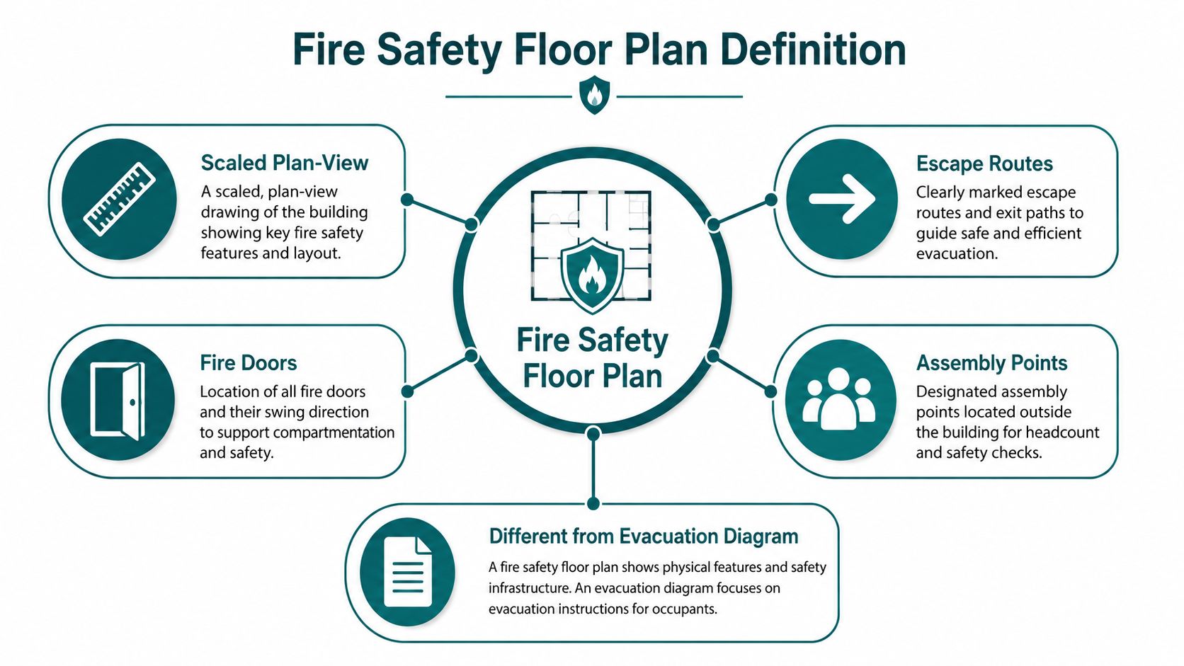
Devon and Somerset Fire & Rescue Service guidance is useful here because it expects floor plans to distinguish life-safety and firefighting systems, not just room layouts (floor plans and building plans guidance). That distinction matters when you're trying to brief a marshal, a facilities lead, or an attending crew under pressure.
Why the drawing has to be technical
A useful fire safety plan needs enough fidelity to show compartmentation and passive protection. That means the plan should reveal protected routes, fire doors, and rated walls, because those are operational controls for limiting smoke spread and preserving escape time. If the drawing flattens those details into a generic floor sketch, it becomes harder to defend in an audit and less useful in the moment.
If you want a non-UK parallel on preparedness thinking, AMPM Restoration Services' disaster readiness resources for Suncoast are a reminder that emergency planning only works when the map matches the actual environment. The same logic applies here.
Mandatory Elements and Symbols Every Plan Must Show
A compliant fire safety floor plan has to be readable at a glance. Staff on the floor, visiting contractors, and emergency crews should not have to decode a drawing while they are under pressure. The symbols, labels, and room geometry all have to work together, and if the plan is crowded, inconsistent, or built on private shorthand, it stops doing its job.
The core elements to place first
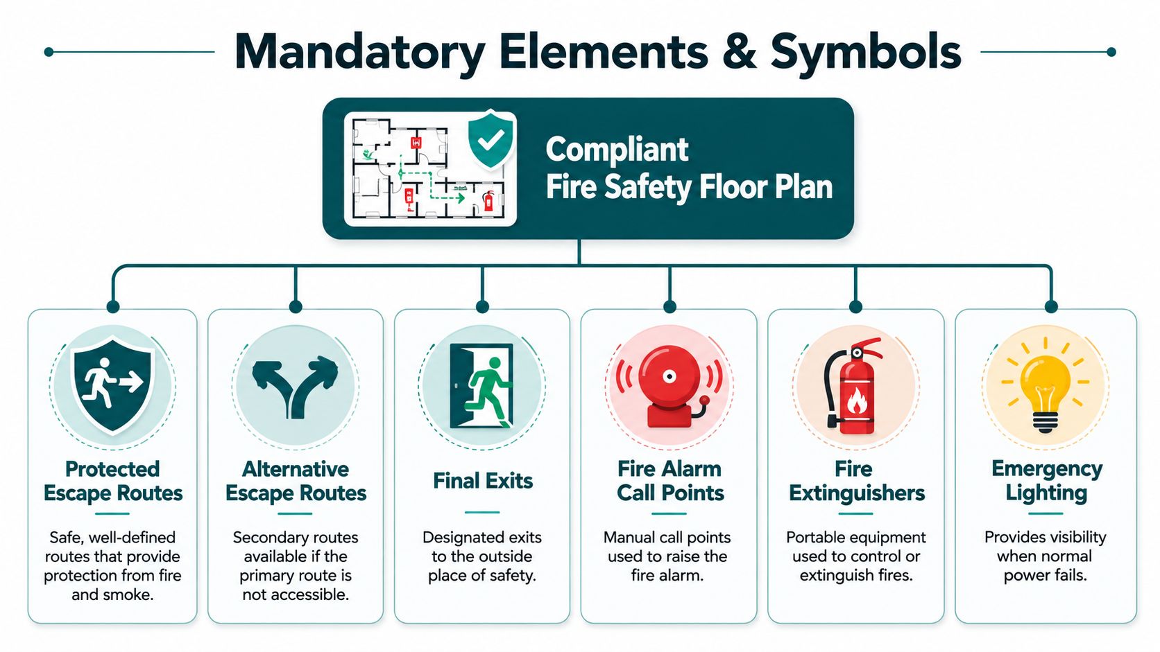
Start with the escape route structure. Protected escape routes should stand out, and any alternative escape routes should be just as clear if the main route is blocked. Final exits need explicit marking, not just corridor doors, because people under stress often stop too early if the difference is not obvious.
Firefighting and life-safety equipment should sit on the same map logic. The plan should show the positions of fire alarm call points, detectors, extinguishers, wet and dry risers, sprinkler isolation valves, firefighting lifts, refuges, and dead-end corridors. The exact icon set can vary, but the meaning cannot. A marshal briefing on a station concourse, or a contractor checking a ward corridor, needs the same clarity.
A few omissions create disproportionate confusion:
- Missing refuge locations leave mobility-impaired occupants without a visible decision point.
- Unmarked firefighting shafts or lifts make responder movement harder.
- Out-of-date extinguisher locations create a false sense of readiness when equipment has moved.
The plan also has to reflect what is on the wall, in the plant room, and in the circulation space. If a detector type changes, or a carbon monoxide unit is upgraded, the drawing should be brought back into line with the building record, just as you would treat Boston carbon monoxide detector replacement as a maintenance change rather than a cosmetic one. That same discipline is what keeps a fire plan honest.
Symbols need to be readable, not merely correct
A plan can follow ISO-style graphical symbols and still fail if the legend is too small or the contrast is weak. The key is legibility from normal viewing distance, with enough clarity to work in low light and under time pressure. That sounds basic, but wall-mounted plans often miss it.
A useful check is whether the plan separates passive fire protection from active equipment. Fire doors and rated walls are not the same as alarms and extinguishers, and the plan should make that difference plain. In UK housing guidance, stairway-enclosing walls and protected common escape routes are expected to provide 30 minutes' fire resistance, and flat entrance doors should be FD30S with self-closing devices. Those details are not decoration, they are the reason a route remains usable.
For teams working on digital overlays, Waymap's floor mapping software resource shows the practical test. The physical plan and the navigational layer have to describe the same space, the same exits, and the same protected routes. If they drift apart, people follow the wrong information.
Practical rule: if a symbol is not instantly understood by a marshal on a noisy concourse, it is not clear enough for an emergency.
The best plans do more than mark rooms and doors. They show the building as a set of choices under stress.
Regulatory and Accessibility Requirements That Shape the Plan
A fire safety floor plan is only useful if it matches the rules the building is being run under. In England, the Fire Safety (England) Regulations 2022 require the responsible person for higher-rise residential buildings to prepare and share electronic floor plans and a single-page building plan with the local fire and rescue service, and the duty started on 23 January 2023 (Regulation 6 fact sheet). That shifts the document from a poster on a wall to an operational record that has to work for responders and building teams alike.
Accuracy, legibility, and currency are legal qualities
Approved Document B expects plans to be clear, current, and tied to the actual escape routes and fire equipment in the building. East Sussex Fire & Rescue Service states that high-rise residential buildings over 18 metres must provide floor and building plans that are accurate, legible, clearly labelled, match the current building layout, and be kept up to date when changes are made. That is the practical standard to work to, because a plan that no longer reflects the building cannot support a real evacuation.
The wider framework is the Regulatory Reform (Fire Safety) Order 2005, which places fire safety management on the responsible person for non-domestic premises. For higher-risk buildings, the Building Safety Act 2022 pushes teams toward a controlled golden-thread of information, so the plan, the as-built record, and the occupied building all stay aligned. In practice, that means version control matters as much as the drawing itself.
Accessibility is a design constraint, not a bonus layer
Many fire-plan articles stop at compliance wording. The Equality Act 2010 requires reasonable adjustments, and that changes how emergency information has to be presented. A plan that is readable to a person standing directly in front of it may still fail a blind or low-vision user who needs accessible route cues, not just a diagram.
That is why fire safety documentation has to sit alongside wider access standards such as BS 8300-2, BS EN 17210, and the NHS Accessible Information Standard in healthcare estates. The point is practical. The plan has to be usable by people with mobility, sensory, or cognitive access needs, not only technically correct for a designer checking symbols on screen. For a related compliance comparison, the DLG Electrical compliance guide shows how legal requirements and practical usability often need to be read together rather than treated as separate tasks.
A static poster can be compliant and still be inaccessible. The real test is whether someone can use the information under pressure.
For teams trying to keep documentation in step with the occupied building, Waymap's building code compliance resource is relevant because it treats building information as something that has to stay aligned with the live environment, not just the drawing package.
Accessibility is part of fire safety. It changes the brief for the plan itself.
Review Cadence and Update Workflow That Keeps Plans Honest
The safest plan is the one someone can trust today. In venues that change often, that means a maintenance process, not a one-time design exercise. If the layout shifts and nobody touches the plan, the document becomes a risk multiplier.
Who owns the update
The responsible person owns the fire safety duty. The dutyholder may carry the organisational responsibility in practice, and a competent person should verify the technical accuracy of the plan where specialist judgement is needed. Those roles have to be named, not implied, or review cycles drift into “someone else dealt with it” territory.
A workable cadence is quarterly, with immediate review after any trigger that changes how people move or how fire safety equipment is accessed.
| Trigger | Responsible Role | Typical Response |
|---|---|---|
| Refurbishment | Dutyholder with competent person | Walk the route, mark deltas, reissue the plan |
| Change of use | Responsible person | Reassess escape logic and equipment labels |
| Fire door replacement | Facilities lead | Confirm door rating and update the plan legend |
| New tenancy | Estate manager | Check route access and shared escape paths |
| Signage relocation | Fire marshal | Align posted information with current circulation |
| Incident or near miss | Responsible person | Review what failed and correct the drawing set |
A five-step update workflow that survives busy buildings
- Pull the current plan from the controlled record set. If you can't find the latest version quickly, version control is already broken.
- Walk the storey with a fire warden or facilities lead. Real circulation beats memory every time.
- Capture deltas against a checklist. Look for route changes, door moves, equipment moves, and dead-end changes.
- Reissue the plan where the regulation requires it. High-rise residential buildings have a formal sharing duty with the fire and rescue service.
- Update the wayfinding layer at the same time. If the sign, the plan, and the digital guidance disagree, users lose trust fast.
A hard truth sits underneath that workflow. A plan that is technically elegant but stale is a worse liability than a simpler plan that's provably current. In a live venue, accuracy wins over polish.
For a more technical documentation lens, Waymap's technical documentation resource is useful because it treats updates as controlled records, not casual edits.
How Dynamic Wayfinding Complements a Static Floor Plan
A wall plan can only do one job, it can show a fixed snapshot. That's useful, but it doesn't solve the moment when a person has already left the wall, entered a corridor, and still needs to know which direction is safe. That's where infrastructure-free navigation earns its place beside the fire plan.

The mechanism matters
Waymap's approach uses dead reckoning with device-native sensors, rather than relying on GPS, Wi-Fi, or installed hardware. That matters in signal-poor environments like underground stations, enclosed concourses, and dense public buildings, where radio-dependent systems become fragile. It also matters in venues with frequent change, because there's no hardware grid to maintain every time a route moves.
In practice, that makes the guidance layer easier to keep aligned with a changing venue. There's no beacon in every doorway, no battery maintenance cycle, and no physical overlay that has to be ripped out and replaced when a tenancy changes. For operators under budget pressure, that difference is not abstract, it affects how much operational friction the system adds.
Named deployments show the operational fit
Waymap has been deployed at Lord's Cricket Ground for MCC, WMATA in Washington, and SBS Transit in Singapore. Those are not identical environments, but they share the same problem, large-scale movement through complex spaces where users need precise, step-based guidance. That's exactly why infrastructure-free navigation is relevant to fire safety planning, because it can extend the static plan into the pocket of the person who needs it.
A fire plan on the wall is useful. A live route instruction on the phone is usable.
The accessibility link is direct. The Equality Act 2010, BS 8300, PAS 78, and BS EN 17210 all push organisations toward information that can be used by disabled people, not merely displayed. For blind and low-vision users, a static diagram is often the wrong format at the wrong moment. A mobile route layer can speak the route in the user's own context, which is a better fit for individualized evacuation awareness.
The same logic explains why Waymap's internal navigation system resource is important for venues aiming to keep escape information current without reprinting. The point isn't to replace the posted fire safety floor plan. It's to make the same geography available at the moment of need, in a form the person can readily use.
Frequently Asked Questions About Fire Safety Floor Plans
How often should a fire safety floor plan be reviewed?
It should be reviewed at least quarterly and after any change that affects routes, doors, or equipment. The current plan has to stay aligned with the building layout and the controlled record set, especially where high-rise residential duties or Building Safety Act expectations apply.
Who is responsible for keeping a fire safety floor plan up to date?
The responsible person is accountable, with the duty usually carried out by the relevant dutyholder and checked by a competent person. That responsibility includes updating the plan after refurbishment, tenancy change, fire door replacement, signage relocation, or an incident.
Can a digital fire safety plan replace a printed one?
No, not by itself. Digital plans can complement posted plans and support the Regulation 6 sharing duty, but occupants still need clear on-site guidance that matches the current layout and is legible in the building.
How do you make fire safety floor plans usable for disabled occupants?
Design them for accessibility from the start, not as an afterthought. That means clear contrast, readable legends, route logic that supports mobility needs, and digital wayfinding that aligns with the Equality Act 2010, BS 8300-2, BS EN 17210, and relevant healthcare or venue guidance.
If you're responsible for a venue, estate, or transport environment, Waymap can help keep evacuation guidance aligned with changing layouts without adding hardware burden. Visit Waymap to see how infrastructure-free navigation supports fire safety floor plans, accessibility, and live wayfinding in the same operational model.
