
Digital Wayfinding System: What Venues Need
A passenger reaches your station entrance with minutes to spare. The signs point to Platform 4, but none of them show the step-free route, and the lift on the shortest path failed this morning. The station is labelled accessible. The passenger still misses the connection. An accessibility label is not wayfinding. If you're responsible for that journey, the useful question is whether your digital wayfinding system can guide someone to the right boarding point on a route they can follow, without depending on GPS, Wi-Fi or installed hardware.
By Tom Pey, Founder of Waymap.
What a Digital Wayfinding System Does That Signs Cannot
A digital wayfinding system provides maintained, point-to-point guidance to a named door, platform, seat, clinic or store. Visitors access it on a phone or through a browser, and the venue updates the underlying information when destinations, routes or building conditions change.
That's different from putting a floor plan online. A visitor needs to know which entrance to use, where to turn and whether the lift on their route is available. A map that shows the destination without resolving those decisions leaves the hardest part to the visitor.
The distinction is between fixed information and guidance that can respond to a particular journey.
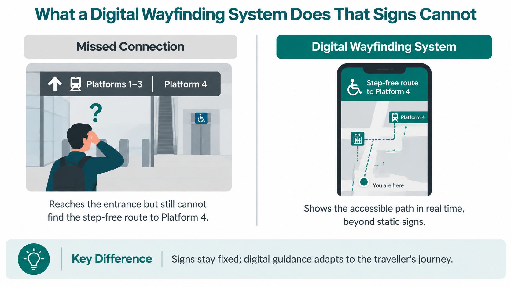
Signs, GPS and a digital wayfinding system
| Capability | Static signage | Phone GPS | Digital wayfinding system |
|---|---|---|---|
| Change after a layout or lift outage | Reprint and refit | No venue control of the indoor path | Publish an update from the venue content system |
| Indoor and underground position | None; the sign is fixed | Signal can be unreliable or unavailable | Sensor-based guidance matched to a floor graph |
| Route to a specific platform, door or store | Only if a sign points there | Usually a street address or entrance | Point-to-point on the mapped graph |
| Step-free path that differs from the shortest path | Separate signs, if installed | Not a substitute for a verified indoor accessible route | Encoded where routes diverge |
| Hardware inside the building | Signs and sometimes kiosks | None | No positioning hardware, or beacons for products that require them |
| Formats | Visual, sometimes tactile | Screen and spoken directions | Visual, audio and other configurable formats |
| Accountable for accuracy | Estates team and signage suppliers | Consumer map provider | Venue, with the navigation provider |
Digital delivery is already familiar to the people who need better transport information. In its 2023 research, the National Centre for Accessible Transport found that 62% of disabled respondents used websites and 57% used apps to prepare for travel; 23% wanted information about the location and availability of maps and wayfinding, while 66% trusted Google Maps most for journey planning, compared with 23% who had confidence in local-authority apps.
For an operator, that isn't an argument for forcing everyone into another app. It's a reason to make authoritative venue information available through familiar, accessible channels.
Where each approach earns its place
Signs offer immediate orientation without a charged phone, permissions or an installation. GPS remains useful for the street journey and for finding the building in the first place. Neither should be discarded just because indoor navigation is available.
Practical rule: Use signs for a glance, GPS for the street and the venue-owned navigation layer for the last metres.
The ownership distinction matters most. A venue can't reasonably promise accurate indoor guidance while treating its entrances, destination names and closures as someone else's responsibility. The digital layer needs an accountable editor, not just a software licence.
How Indoor Positioning Works Without a Satellite Fix
Indoor positioning is better understood as movement on a known plan, rather than a satellite dot moved inside a building. GPS signals can become unreliable indoors, underground and between tall structures. Wi-Fi coverage doesn't automatically provide a dependable positioning service either.
A workable indoor navigation system therefore separates the building model, the route calculation and the estimate of where the person is moving. Buying an attractive map doesn't establish that the positioning will work.
The main relationships are straightforward.
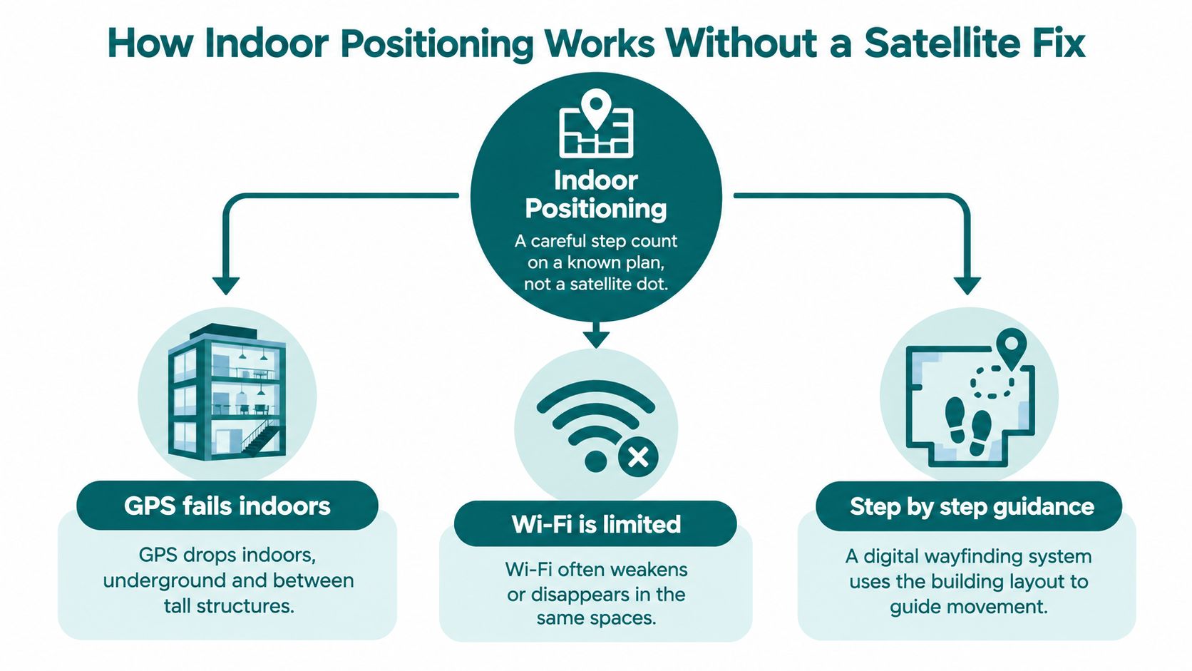
The components need to work together
A useful architecture contains these components, in this order:
- A venue-owned map model containing entrances, lifts, platforms and stairs, with connected paths rather than disconnected drawing objects.
- A routing engine that computes standard and step-free alternatives from that model.
- A content system where authorised venue staff publish closures, renamed points of interest and approved changes.
- A phone-side positioning module that combines motion-sensor information with the map.
- Output layers for on-screen directions, audio instructions and browser delivery.
Our technical approach at Waymap uses smartphone inertial sensors and AI algorithms rather than GPS, Wi-Fi positioning or installed Bluetooth beacons. We combine the venue's plans with movement patterns to build the navigation model, and adapt instructions to the user's stride and movement.
Dead reckoning estimates movement from a known position. Accelerometer and gyroscope readings help estimate steps and turns; a positioning algorithm compares that movement with plausible paths through the building. Map matching constrains the estimate, but it doesn't make an incorrect floor plan accurate or eliminate every possible positioning error.
An accuracy promise is useful only when it states the test conditions. Require the route, device models, floor transitions, walking conditions and error measure behind any distance claim. A successful demonstration along an empty straight corridor doesn't establish performance at a crowded junction.
Our explanation of an indoor positioning system provides further context for evaluating that architecture.
Infrastructure-free doesn't mean preparation-free
A navigation system still needs a verified model, sensible instructions and live testing. Eliminating beacons removes a hardware estate, not the responsibility to understand the building.
Beacon installations introduce batteries, mounting locations, replacement stock and access arrangements for maintenance. Refits can move or obscure equipment, while staff turnover can leave no clear owner for it. NHS estates teams should examine that burden alongside capital approval requirements; metro maintenance teams should examine it alongside access restrictions and passenger service.
Multi-level navigation needs particular attention. Test the transition into a lift, arrival on the destination floor and the first instruction afterwards. Different walking styles also need testing, rather than assuming that a route which works for the demonstrator will work for everyone.
This demonstration gives a visual reference for the navigation experience.
Positioning establishes where someone is likely to be. It doesn't decide which doors, lifts or corridors ought to be available to them. That's a route-model and operations decision.
What the Route Graph Must Include
A step-free station badge is not a route. It doesn't tell a passenger whether the relevant entrance connects to their platform, whether an accessible toilet lies on that path or whether boarding requires assistance.
The Disabled Persons Transport Advisory Committee reference frame reports that fewer than 2% of Great Britain's stations provide level access between train and platform, that 33% have a vertical or horizontal platform gap exceeding 25 centimetres in some places, and that 67% have platforms too narrow in places for a compliant wheelchair turning circle at the base of a ramp; it also records accessible toilets at 35% of stations and Changing Places toilets at 0.2%.
Those are route-specific constraints. Reaching the station address doesn't resolve them.
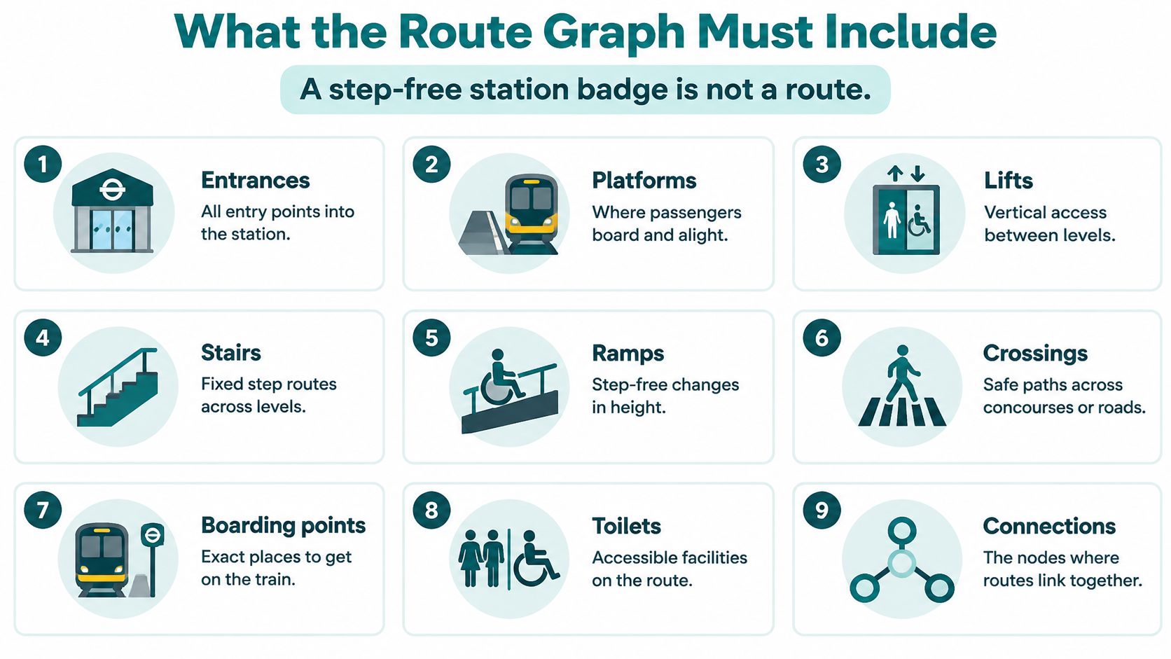
Model connections, restrictions and changing conditions
A route graph represents destinations and decision points as nodes, joined by traversable paths. It should include entrances, platforms, lifts, stairs, ramps, crossings, boarding points and toilets. It must record where a step-free route leaves the otherwise shortest path.
Each connection needs usable attributes. A staircase isn't just a line; it's a connection that some users must exclude. A door may be public during certain opening hours but staff-only afterwards.
Operational state belongs in the model too:
- Lift availability: A failed lift must invalidate the affected connection, not merely add a warning beside an unchanged route.
- Temporary restrictions: Closed gates, construction hoardings and event barriers must alter available paths.
- Destination status: A relocated clinic or closed concession must stop appearing as an ordinary reachable destination.
- Boarding requirements: Directions must distinguish reaching the platform from reaching the appropriate boarding point.
The Office for Statistics Regulation's review of transport accessibility statistics identifies the need for high-quality, quality-assured accessibility information. Operators should apply that principle to each navigable connection, not only the station's overall classification.
Route-graph measures operators can audit
| Measure | What it tests | How to read it |
|---|---|---|
| Routes with a verified accessible alternative | Whether step-free and standard paths are both modelled | A venue label isn't enough if the alternative is missing |
| Time from change to published update | Whether a closure or new tenant reaches the app before the next peak | Planned works should be live before they start; failures require immediate action, with publication before the next peak as a backstop |
| Reroute success after a closure | Whether guidance changes when a lift, gate or corridor shuts | Failure means people are still sent onto the blocked path |
| Arrival at the exact platform or door | Whether the trip ends at the named point, not the building centroid | This is the outcome user tests should record |
Record the denominator behind each measure. Accessible-route coverage means little if difficult destinations have been excluded from the test set.
A route optimisation algorithm can select only from the connections and restrictions it has been given. Reject a pilot that demonstrates arrival at a station or shopping-centre address but can't complete the journey to the named destination.
Where Digital Wayfinding Changes the Journey
The operational test changes with the venue. A passenger needs the correct platform, a shopper needs the actual storefront and a patient needs the right department entrance. A single arrival pin is inadequate in each case, but the reason for investing differs.
These environments share a need for precise destinations, despite very different visitor journeys.
Transit needs continuity through the interchange
In indoor testing at Birmingham New Street, Waymap showed significantly higher location accuracy than GPS-based navigation. That result addresses a specific operational problem: outdoor positioning isn't a sufficient basis for guidance across concourses and platforms.
A useful transit acceptance test starts outside the station and finishes at a named boarding point. It includes the entrance choice, vertical movement and an interchange decision, rather than stopping when the passenger crosses the building boundary.
At CapMetro in Austin, the deployment includes step-free routing and personalised navigation settings. For a transport operator, the practical issue is maintaining those choices across a changing network without adding another hardware-maintenance task to already constrained station teams.
Retail needs the storefront, not the centre
At Liverpool ONE, user testing showed that visitors successfully reached exact store destinations using Waymap. The app also led to a notable reduction in use of static wayfinding kiosks for directions.
That makes the retail case more concrete than an accessibility slogan. Visitors can find the unit they intended to visit, while the operator can examine how demand for staffed and fixed-screen directions changes.
Tenant moves, temporary concessions and renamed stores create the maintenance friction. The retail content owner needs a publication workflow aligned with leasing and store-opening information, not a separate map update that happens after visitors have already encountered the change.
A destination is only useful when its public name, entrance and current location agree.
Stadiums and healthcare need different acceptance tests
For a stadium such as Lord's Cricket Ground, managed by Marylebone Cricket Club, a useful trial would follow a supporter from the arrival point to a named seat, an amenity and the appropriate exit. Event peaks, unfamiliar visitors and ticket-specific entrances make that a different test from walking through an empty venue.
Lower-carbon matchday planning should be assessed through the complete public-transport journey, not claimed as an automatic consequence of installing indoor guidance. The operator needs evidence of travel behaviour before reporting an environmental outcome.
For healthcare, consider the journey to a named clinic at the Royal Hospital for Children and Young People as an acceptance-test scenario, rather than treating the hospital address as completion. NHS estates teams must account for capital approval cycles, department moves and the difference between a public entrance and a staff entrance.
University estates face a related issue when teaching rooms and departments move. A station, shopping centre, stadium and campus can share a content model of destinations, connections and restrictions, even though the names and operating responsibilities differ.
Why Accessibility and ESG Depend on the Route
In 2022, disabled adults in England made an average of 686 trips per person, compared with 916 for non-disabled adults, a 25% difference that the Department for Transport described as broadly consistent with previous years; disabled adults made 6% of their trips by bus, compared with 4%, and 18% as car passengers, compared with 12%.
Navigation can't explain or remove that entire mobility gap. Physical access, service availability and assistance remain separate requirements. But a wrong entrance or unavailable connection adds another barrier to a journey that may already be difficult to replan.
The appropriate objective is independent arrival where possible, with dependable assistance where needed. Don't convert that objective into an unsupported promise about health, safety or reduced transport exclusion.
Make inclusion measurable in ordinary operations
A practical inclusion programme should connect its reporting to what visitors can complete:
- Verified accessible alternatives: Report the count of destinations with a checked alternative route, alongside the total destination set.
- Exact-arrival rate: Record whether visitors reached the named door or boarding point without being rescued by the test facilitator.
- Staff direction workload: Measure repetitive directional enquiries before claiming that staff time has been released.
- Reprinted maps and replaced kiosks: Keep purchasing and replacement records rather than assuming digital delivery automatically reduces physical assets.
The first two measures directly support the social pillar of an ESG report because they describe access to services. Reduced reprinting or kiosk replacement supports that story only when the venue shows that information remained available to visitors who don't use smartphones.
Environmental reporting needs a separate boundary and method. Fewer printed maps isn't, by itself, an evidenced carbon saving.
Design for different needs without a separate entrance
Step-free routes, accessible toilets and food preferences should sit within ordinary journey settings. A visitor shouldn't have to identify with a particular disability category before finding the option they need.
The design context includes BS 8300, BS EN 17210, PAS 78 and the UN Convention on the Rights of Persons with Disabilities. Treat these as references to examine with the relevant accessibility specialists, not as a claim that navigation software alone establishes compliance or that every document has the same scope.
An accessible wayfinding programme must also retain lifts, ramps, tactile information, physical signs and human assistance. Clear digital directions to an unusable doorway don't constitute access.
Reporting discipline: Measure completed journeys, not just installed features or downloaded apps.
General visitors matter to the maintenance case. When shoppers, commuters, students and staff all use the same destination model, more people can identify incorrect names and closures. That shared use gives the venue a stronger operational reason to keep the accessible graph current.
How to Procure a Digital Wayfinding System
Buy a demonstrable journey and an operating process, not a polished map. The tender should establish what a visitor must reach, who maintains that information and how the venue will recognise a failed trip.
For NHS estates, the constraint may be capital approval before hardware installation. Transport teams face maintenance across changing stations; retail teams need to justify destination discovery and visitor experience, not compliance alone.
Follow a destination-led buying process
Name the destinations that cause missed arrivals. Start with platforms, clinics, gates, accessible toilets and difficult entrances. Use enquiry logs and staff input to select the places that cause confusion in practice.
Define the reasonable-adjustment job. The government's reasonable-adjustments guidance explains that the Equality Act 2010 duty can involve accessible information, policies, staff training and physical alterations. Specify which information disadvantage the system should address while recognising that delayed physical works remain a separate responsibility.
Require an infrastructure-free option. Cost beacon installation and upkeep only if a live trial establishes that a hardware-free approach cannot meet the agreed route requirements. Include maintenance access, replacement equipment and refits in the comparison.
Test indoors against GPS. Use a working concourse or public level, include floor changes and introduce a lift-outage reroute. Record the point where guidance fails, not just whether the demonstrator eventually arrives.
Give content control to the venue. Have an authorised staff member hide a destination, rename it and publish the approved change during the trial. A developer release shouldn't be the routine method for changing a shop name.
Check modalities and entry routes. Test spoken, visual and simpler instructions, plus a browser route opened from a QR code. Establish which functions are available in each channel rather than assuming browser and native-app behaviour are identical.
Pilot a bounded live area. Measure exact arrival, failed instructions and content-update performance before extending coverage. Include visitors with different access needs, walking styles and levels of digital confidence.
Vendor checks before you award
| Check | Pass looks like | Fail looks like |
|---|---|---|
| Indoor accuracy | Stable guidance through a concourse, platform or mall without GPS | Position jumps or only an outdoor pin |
| Infrastructure | Works with phone sensors and a map, hardware optional | Beacons required before any route can run |
| Accessible graph | Step-free paths can differ from shortest paths and include toilets and boarding points | One route for every user, or essential choices hidden in a separate accessibility mode |
| Update control | Venue staff publish an approved closure or renamed store the same day | Every change needs the vendor's developers |
| Modalities | Audio, on-screen guidance and a simpler instruction set | Audio only, or screen only |
| Access without a download | Browser route from a QR code alongside iOS and Android options | App-store installation required for every visitor |
| Handover trial | Exact-arrival test on a live level, including a closure | Demonstration on slides or an empty test floor |
Use these vendor selection criteria to structure evidence requests and contract acceptance. Infrastructure-free positioning and venue-controlled publishing are especially relevant when a trial must run without an equipment installation.
Cost the integration as carefully as the navigation. Gegan's guide to understand hidden app development expenses is a useful budgeting prompt for branded-app work; keep that budget separate from mapping, accessibility testing, content ownership and ongoing support.
Don't accept a single implementation figure without knowing who pays when the estate changes.
What Does It Take to Keep a Digital Wayfinding System Accurate After Launch
Appoint a named venue navigation content owner, with a deputy and an escalation route. That person should receive notices of closures, renamed stores and new facilities alongside the teams that update signs and public information.
Set a publication target: planned changes before they take effect, and unexpected closures as soon as verified. A same-day target isn't permission to leave a known blocked route active.
Keep a test and incident record
- Walk-test each level quarterly: Check entrances, lifts, toilets and boarding points, and log every wrong arrival.
- Separate device failures: Record phone class, operating system and stride-learning state so a positioning issue isn't mistaken for a map error.
- Measure battery use: Complete representative journeys on mid-range iOS and Android devices before launch and after significant releases.
- Document privacy: State what location information is processed on the device, what leaves it, retention periods and who can access it. Have the privacy team assess data minimisation and whether a data protection impact assessment is required.
Our implementation best practices can help organise the operational handover. Give visitors a visible wrong-entrance reporting route connected to the venue's content queue.
Keep entry points and fallback help usable
QR entry points need ownership too. RedirHub's explanation of how to turn packaging scans into useful customer journeys offers a transferable principle: maintain the destination behind the code, rather than treating the printed code as the finished service.
Name the staff team that answers when guidance fails. The venue owns destination and route information; the navigation provider investigates positioning faults. Physical signs and human assistance remain the fallback.
Frequently Asked Questions About Digital Wayfinding Systems
What is a digital wayfinding system?
A digital wayfinding system provides maintained, point-to-point guidance to a named destination, rather than just displaying a building map. Visitors can access directions directly, through a venue's branded app or through a browser, according to the deployment.
Does a digital wayfinding system need Wi-Fi, GPS or beacons?
No. Infrastructure-free navigation can use smartphone motion sensors and a venue model without GPS, Wi-Fi signal dependency or installed positioning hardware. Distinguish that positioning capability from the connectivity needed to obtain initial content or receive newly published updates.
Should one audio mode serve every disabled visitor?
No. The National Centre for Accessible Transport's highlights report identifies wayfinding as important to 23% of disabled respondents and describes the need for clear signage, audible announcements for people with visual impairments and visual displays for people with hearing impairments.
Keep hands-free audio for those who benefit from it, alongside captions, visual guidance, simpler instructions and configurable vibration where supported. Consider BSL guidance, downloadable route information, battery use and privacy during design, while retaining staff support for digitally excluded visitors.
How quickly must a closure appear?
Immediately after verification where the closure affects a live route, with publication before the next peak as an operational backstop. Planned restrictions should be published before work begins. These are recommended operating targets, not a universal statutory deadline.
Can a digital wayfinding system replace signs?
No. Signs provide orientation without requiring a device, while digital guidance supports a visitor's individual destination and route. Keep the two consistent, especially at entrances and decision points.
Does digital navigation replace lifts, ramps or staff?
No. It provides information about usable paths and available assistance; it doesn't create physical access. Where no suitable route exists, the system should say so rather than present an unsuitable path as an accessible alternative.
What should a pilot measure?
Exact arrival at the named platform or door should be the primary outcome. Include a closure reroute and record wrong turns, facilitator intervention and unsuccessful journeys, not just completed demonstrations. A no-download browser entry, such as a QR-accessed web route, should also be tested with visitors who haven't prepared in advance.
Waymap offers indoor, outdoor and underground navigation to exact destinations without relying on GPS, Wi-Fi positioning or installed hardware. Visit Waymap to discuss a live pilot built around your difficult entrances, step-free alternatives and closure-update workflow, with success measured at the actual platform, store or door.
