
Dead Reckoning Explained for Indoor Navigation
Can a navigation system place someone in the right corridor yet still fail to get them to the right door? Dead reckoning makes that distinction important. It estimates position from movement rather than repeatedly asking a satellite or nearby transmitter where the user is.
For estates and transit leads, the useful question isn't whether a phone can follow a walk through an empty corridor. It's whether people with different walking styles, devices and access requirements can reach the intended entrance when signals disappear and hardware maintenance isn't funded. At Waymap, we judge the method through that operational lens: position, uncertainty, correction and successful arrival.
How Dead Reckoning Estimates Position from Movement
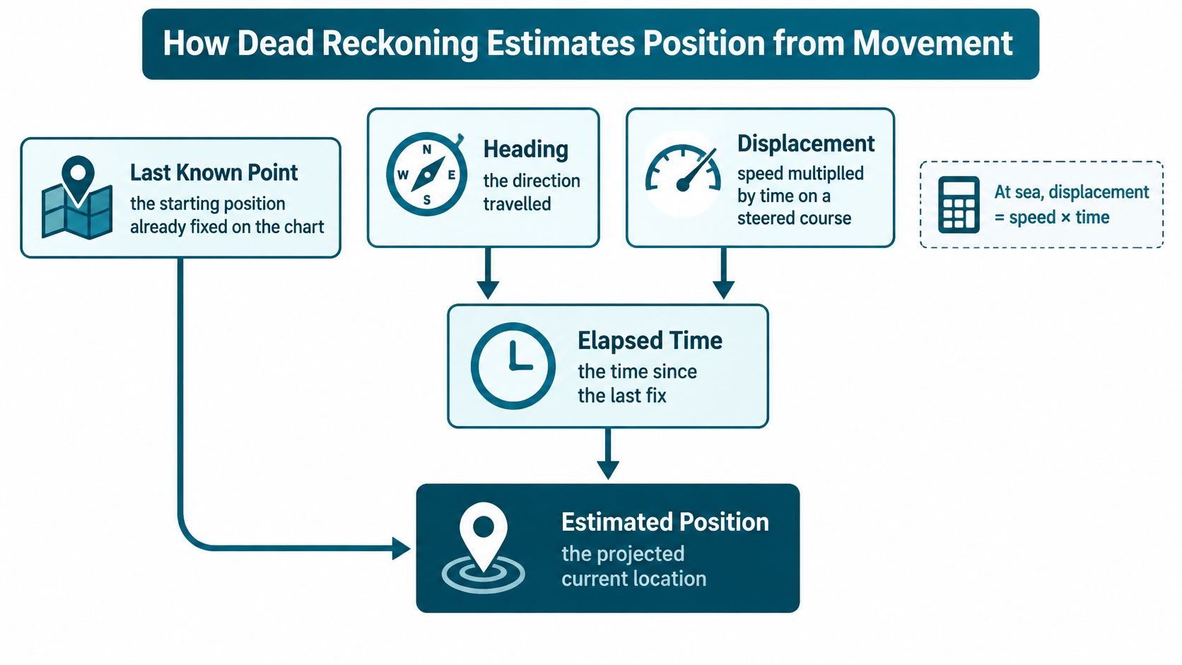
Dead reckoning estimates a current position by projecting forward from a known point using heading, displacement and elapsed time. At sea, displacement is speed multiplied by time along a steered course. On foot, pedestrian dead reckoning estimates the distance and direction of successive steps.
Think of leaving a known door, closing your eyes and mentally counting paces and corners towards another door. This is an analogy, not a suggested navigation exercise. If you miss a pace or misjudge a turn, every later estimate begins from the wrong place.
The position update is straightforward:
New position = previous position + estimated step length along the current heading.
The phone doesn't measure coordinates directly through this process. Software calculates them from movement measurements and an initial position.
What the phone measures
The main inputs are the accelerometer for step timing, gyroscope for rotation, magnetometer as a weak indoor heading aid, and barometer for floor-change hints. These measurements have different jobs. Detecting movement doesn't, by itself, establish which corridor someone occupies.
The relationship between the inputs looks like this:
Two assumptions deserve attention before any algorithm becomes complicated:
- Starting position: Beginning at the wrong entrance shifts the entire estimated track.
- Step length: Applying one fixed distance to every step turns ordinary differences in walking style into distance error.
- Travel direction: The direction the phone points isn't necessarily the direction its owner walks.
A University of Cambridge survey of pedestrian dead reckoning concludes that the method can support useful short- to medium-term indoor tracking, but longer operation generally needs periodic absolute fixes or map-based corrections. That distinction separates a continuous estimate from a permanently trustworthy position.
Why walking models matter
A person may shorten their steps in a queue, pause at a barrier or turn while holding their phone sideways. A useful movement model must accommodate those behaviours rather than assume a steady laboratory walk. Our explanation of walking-pattern recognition provides context for that modelling problem.
For a parallel outside pedestrian navigation, pilot navigation guidance from DuBois Aviation explains how heading, speed and time support an estimate between position checks. Indoor navigation changes the measurements, but not the need to distinguish a projection from a confirmed location.
This article is written by Tom Pey, Founder of Waymap and a blind accessibility technologist who built the product from his own experience as a blind person.
Dead Reckoning Against Other Indoor Positioning Methods
Indoor positioning methods compared with dead reckoning
| Method | What it needs | Works with no radio fix | Main deployment failure | Fits when |
|---|---|---|---|---|
| GPS or GNSS | Satellite view | No | No fix indoors and multipath outdoors | Outdoor approaches only |
| Wi-Fi positioning | Access points and a radio survey | No | Survey goes stale when the network changes | Dense, stable Wi-Fi |
| Bluetooth beacons | Installed beacons and upkeep | No | Batteries, theft, gaps and retuning | Fixed routes with a hardware budget |
| Ultra-wideband | Anchors installed in range | No | Cost and limited coverage | Small high-precision zones |
| Magnetic fingerprinting | A magnetic map of the building | Yes, if mapped | Refits can force a new survey | Corridors with stable steel |
| Pedestrian dead reckoning | Phone accelerometer and gyroscope | Yes | Drift grows with time, gait and heading | Infrastructure-free venues and tunnels |
The procurement choice is partly about positioning technology and partly about what the operator can maintain. Installed equipment needs an asset owner. Phone-based movement estimation needs a credible starting position, a suitable movement model and a correction layer.
What installed positioning requires
Satellite navigation is useful on outdoor approaches, but a route that continues into a basement, covered concourse or tunnel needs another positioning method. Reflected signals can also confuse the transition between street and building. Our explanation of whether GPS works indoors addresses that boundary.
Wi-Fi positioning uses the surrounding radio environment as a location reference. Access points installed for connectivity aren't automatically a maintained positioning system: moving equipment or changing network configuration can invalidate the relationship between signals and surveyed locations.
Bluetooth beacons introduce a more deliberate reference network. The operational questions are concrete: who replaces batteries, investigates missing devices and checks coverage after a refurbishment? A successful installation isn't evidence that those responsibilities will remain funded.
Ultra-wideband anchors can suit a bounded area where precise positioning justifies dedicated equipment. Extending that arrangement across an estate introduces coverage planning, installation access and maintenance responsibilities that a small demonstration may not expose.
What infrastructure-free positioning still requires
Magnetic fingerprinting avoids a live radio fix, but it doesn't avoid site preparation. It compares measurements with a surveyed magnetic map, so significant changes to the building's magnetic environment may require another survey.
Pedestrian dead reckoning instead carries the estimate with the handset. The movement calculation can continue without GPS, Wi-Fi, Bluetooth or mobile data, provided the required software and local map are available.
The price of that independence is accumulated error from time, gait and heading unless a later correction re-anchors the track.
Choose installed kit where someone will keep it calibrated and maintained. Otherwise, budget for an inertial estimate and its correction layer, not an uncorrected moving dot.
“Infrastructure-free” describes the absence of positioning hardware. It doesn't mean map-free, preparation-free or maintenance-free. For a shopping centre, stadium or metro, that distinction should appear in the operating model before it appears in a procurement specification.
Why Small Sensor Errors Become Large Drift
Drift is a chain of errors, not one defective reading. Each estimated position becomes the origin of the next update, so an apparently minor discrepancy can eventually place someone beside the wrong lift or platform entrance.
A review available through the University of Oxford Research Archive reports that step-detection rates are generally above 90%, while stride-length and heading errors can exceed 10% in some methods. It also identifies unstable heading observability during unconstrained phone use as a fundamental limitation. Counting most steps correctly therefore doesn't establish that the resulting track is correct.
Dead reckoning error sources and corrections
| Error source | How it appears | Correction |
|---|---|---|
| Wrong start position | Whole route shifted by a fixed offset | Begin at a mapped door, barrier or platform entrance |
| Missed or extra steps | Arrival too early or too late along the path | Step detection checked against the user's own pace |
| Fixed stride length | Distance error grows with every step | Stride updated from recent walking, not a single average |
| Heading bias | Track rotates into the wrong corridor | Gyroscope turns constrained by the map |
| Magnetic distortion | Sudden compass jumps near steel or motors | Down-weight the magnetometer indoors |
| Phone placement and gait | Different error for pocket, hand, slow pace or a walking aid | Test by placement and mobility, not one lab walk |
| Missed floor change | Right horizontal position, wrong storey | Barometer plus lift and stair geometry |
Why a convincing demonstration can mislead
A tester who starts at a verified point and walks steadily with a phone held upright removes several difficult conditions. Passengers don't necessarily behave that way. They stop to listen, move around other people, put phones into bags and change pace near barriers.
Heading errors are particularly consequential because they move the estimate sideways as well as forwards. A track can appear smooth while gradually rotating towards a parallel corridor. Steelwork, motors and trains can also make a compass-derived correction less trustworthy rather than more useful.
Our guide to inertial measurement units explains the sensor combination behind these measurements. For acceptance testing, however, the important task is to connect each observed failure to its likely cause.
What an inclusive test must record
Split results by phone placement, pace, mobility profile, route complexity and magnetic conditions. Include people who use walking aids, people who pause frequently and people whose steps don't resemble the training model.
- Record the failure point: Identify the junction, level change or entrance where guidance became misleading.
- Record the response: Note whether the system acknowledged uncertainty, attempted recovery or continued issuing confident instructions.
- Record the destination: Confirm the actual door reached, not just the final coordinate displayed.
A single accuracy percentage hides these differences. Pair every unsuccessful test walk with a row in the error table, then test whether the proposed correction resolves that failure without creating another.
What the Map Must Contain Before Guidance Is Useful
51% of people with sight loss found public transport facilities difficult to use, while only 39% found them very or fairly easy, according to Motability Foundation transport-accessibility research. Reaching a station isn't the same task as finding its correct platform entrance.
A movement estimate becomes useful guidance only when the venue map describes the decisions a person must make. A floor outline and destination pin aren't enough.
Which attributes belong in the navigation map
The operational map should include:
- Decision points: Named doors, platform entrances, ticket barriers, crossings and corridor junctions.
- Accessible routes: Step-free connections, slopes, surfaces and relevant physical constraints.
- Vertical connections: Lift and stair locations, connected floors and lift availability.
- Live restrictions: Temporary closures, blocked entrances and changed routes.
- Destination identity: The exact entrance associated with a shop, service or platform.
Georeferencing a map aligns venue geometry with position estimates. Operators must also assign responsibility for the information attached to that geometry. Someone needs authority to mark a lift unavailable and publish the alternative route.
The consequences of missing support are tangible: the Sight Loss Councils' transport report found that 100% of respondents who used an unstaffed station reported an issue with their journey.
Why governance belongs in the deployment decision
The Equality Act 2010 reasonable-adjustment duty, BS 8300, BS EN 17210 and the UN Convention on the Rights of Persons with Disabilities belong in the accessibility review; US sites should also assess ADA Title III. These aren't product certifications, and they don't prescribe a particular positioning technology. They make access needs relevant to the choice and operation of wayfinding.
For NHS estates managers, capital-approval cycles can obstruct a beacon installation. Transport operators face hardware upkeep across busy, changing stations. Retailers need shoppers to find the intended store, not abandon the visit after reaching the wrong entrance.
Operational test: A maintained route to the correct door is more useful than a precise position attached to stale venue information.
Removing positioning hardware doesn't remove the obligation to maintain the map.
How to Correct Drift on a Live Track
Correction should be part of ordinary operation, not an emergency feature added after a failed trial. The system needs to evaluate movement against the building while preserving uncertainty wherever several locations remain plausible.
A correction sequence for indoor navigation
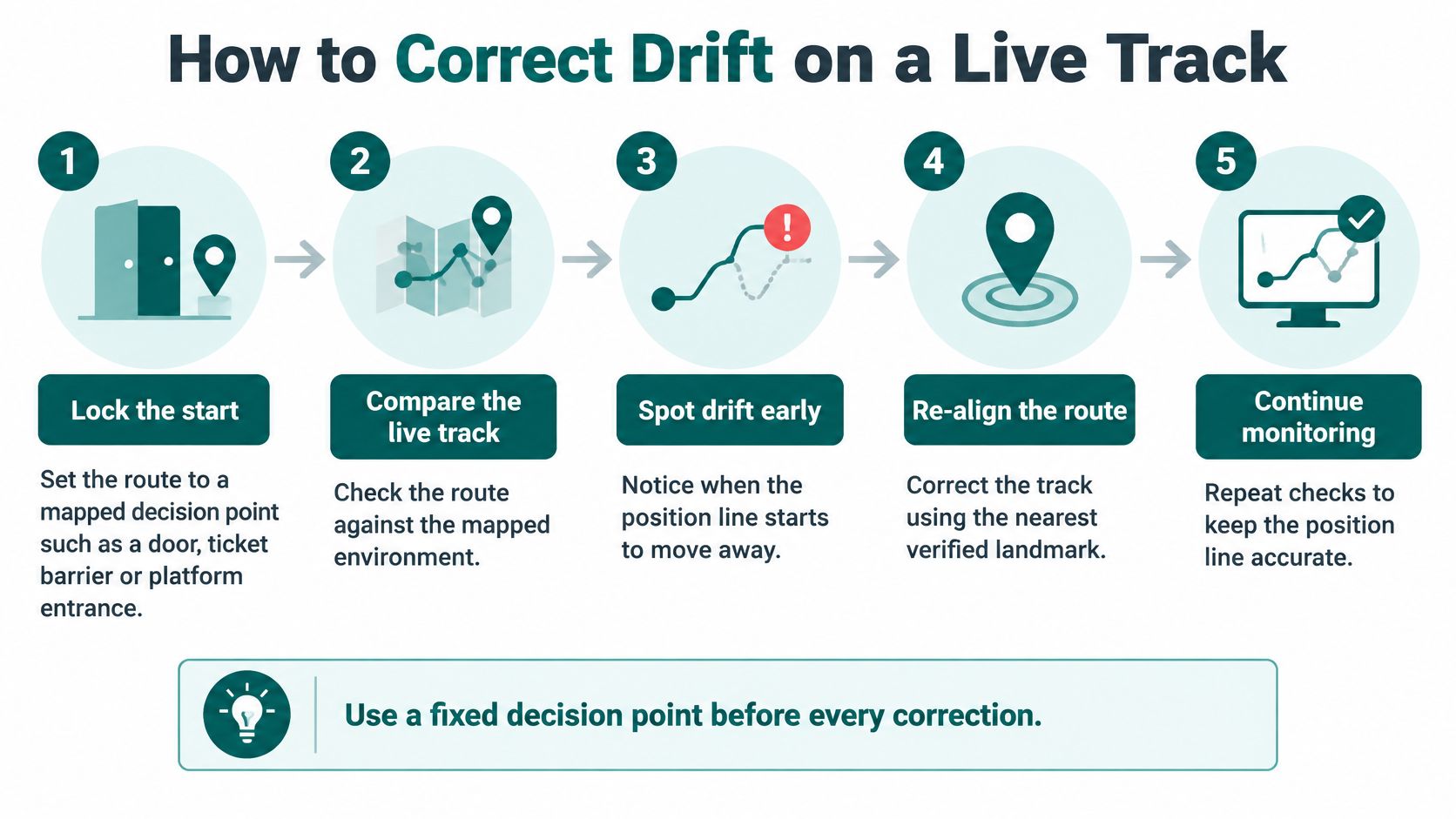
Lock the start to a mapped decision point. Use an identifiable door, ticket barrier or platform entrance. If the initial position is uncertain, retain that uncertainty rather than selecting a convenient origin.
Detect steps and update step length from the walker's recent movement. Don't assume that a population average remains appropriate through queues, turns and changes of pace.
Integrate turns and assess heading confidence. Use rotational measurements to follow changes of direction. Treat magnetic heading as optional where local interference makes it unstable.
Constrain candidate positions to the building. A proposed route through a wall should lose support; a route through a mapped corridor, staircase or lift should remain possible. Don't force every estimate onto the planned route, because the user may have taken another valid path.
Carry a cloud of possible positions. A particle filter represents alternative locations, each with a probability or weight. Remove impossible candidates and favour those consistent with both movement and map geometry.
Re-anchor when a sufficiently distinctive cue arrives. A verified visual landmark can provide an absolute reference. A turn sequence or pressure change can narrow possibilities, but shouldn't be treated as an independent position fix unless it uniquely identifies the location.
The operational checks can be represented as a repeating cycle:
What map matching can and can't establish
Map matching doesn't improve the physical sensor. It prevents an impossible interpretation of the measurements from being treated as certain. Parallel corridors and similar entrances may remain ambiguous until another distinguishing observation becomes available.
A sensor-fusion algorithm must therefore consider the reliability of each input, not combine everything with equal confidence. When competing positions remain plausible, guidance should communicate that limitation and support recovery.
Professional navigation retains the same cross-checking principle. In the Maritime and Coastguard Agency navigation/deck survey, 94% of respondents agreed that terrestrial and coastal navigation training remained relevant; the review also recommended simulator exercises involving dead reckoning on Electronic Chart Display and Information Systems.
Long uncorrected operation is the wrong acceptance test for corrected navigation. Test whether the system recognises disagreement, uses valid constraints and recovers before presenting a doubtful location as fact.
Where Dead Reckoning Is Used from Sea to Stations
The maritime lesson is about checking an estimate, not abandoning it. A charted track can look orderly even when the vessel's true position has diverged.
Traditional navigation tools make that distinction visible:

On 22 October 1707, four Royal Navy warships returning from Gibraltar towards Portsmouth struck rocks near the Isles of Scilly after more than 1,000 miles relying heavily on estimated position; their calculated position was reportedly about 100 miles from their actual location, and only 26 of the 1,647 people aboard survived, as described in The Critic's account of the disaster. The relevant lesson is that competent records don't eliminate accumulated uncertainty.
Aviation offers another context for learning to manage navigation inputs. Readers interested in formal instrument-flight training can explore the Southern California instrument rating program, while keeping aircraft procedures distinct from pedestrian guidance.
What the London Underground example actually proves
A University of Brighton study of London Underground passenger tracking evaluated smartphone accelerometer data across approximately 940 kilometres, 381 stations and 11 lines, identifying the travelling line and departure station with accuracy of up to about 90% when observations covered at least three station stops. Its tunnel-tracking setting lacked the positioning signals on which conventional location services depend.
The study also used principal-component analysis to track progress along a line when rush-hour movement departed from the schedule. This is a constrained rail problem: trains follow known tracks and produce recognisable movement patterns.
The accompanying video offers another way to approach navigation without a conventional position fix:
Network inference over a sustained observation window isn't guidance to a platform entrance. A passenger application still needs station geometry, route topology and an explicit treatment of uncertainty before it can turn inferred travel into useful walking instructions.
When Should You Rely on Dead Reckoning Indoors
Use dead reckoning indoors when radio positioning or beacon upkeep can't be relied on, and when the deployment includes a maintained map, adaptive movement estimation and correction. Don't use an uncorrected sensor trace as the only wayfinding provision in a complex station.
Our core approach uses a particle filter grounded in probability theory and Bayesian statistics. Waymap Core's AI-powered SmartStep motion-based positioning uses the phone's own sensors for step-by-step navigation, with audio guidance and step-free routing. Once the app and relevant maps are downloaded, navigation doesn't require GPS, Bluetooth or mobile signal.
What evidence should justify a trial
In user testing at Liverpool ONE, people successfully reached exact store destinations using Waymap. That is a useful outcome to test in another venue, not a promise that every layout or walking condition will produce identical results.
For estates, transit and retail teams, select a mapped route where installing positioning hardware would face capital-approval or maintenance obstacles. Include the operational difficulty that matters: an alternative entrance, a level change or a route affected by closures.
A cruise ship comparison can help travel planners compare ships, but it doesn't establish whether someone can get around a particular vessel's interior. Apply the same distinction to venue procurement: destination information and verified internal guidance are separate requirements.
Acceptance criterion: Record whether diverse users reach the intended entrance, how uncertainty is handled and who maintains route changes.
Waymap is a secondary navigation tool and shouldn't be solely relied on. A deployment decision should account for existing assistance, signage and recovery options, not just the app demonstration.
Frequently Asked Questions About Dead Reckoning
What is dead reckoning?
Dead reckoning estimates position from a known starting point using movement and direction over time. It provides continuity between confirmed locations, rather than independently confirming every new position.
Does dead reckoning work without GPS?
Yes, pedestrian dead reckoning can calculate movement without GPS or a live radio fix. The application still needs the relevant local resources, including its venue map, available on the device.
How accurate is dead reckoning indoors?
There isn't a single accuracy figure that describes every indoor deployment. Assess results by walking style, phone placement, route complexity and duration, then check whether users reach the intended entrance.
Does dead reckoning work on the London Underground?
Motion sensing can support tracking on the London Underground, but identifying a train journey isn't the same as guiding a passenger through a station. Walking guidance requires a separate understanding of entrances, connections and levels.
What is the difference between dead reckoning and GPS?
GPS derives position from satellite signals, while dead reckoning calculates position from a starting location and subsequent movement. They can complement each other where a journey crosses between outdoor and indoor environments.
Why does pedestrian dead reckoning need map corrections?
Map corrections help reject movement interpretations that conflict with the building. They can't resolve every ambiguity, especially where nearby corridors have similar geometry, so uncertainty must remain visible to the positioning system.
How does Waymap use dead reckoning?
We combine smartphone movement estimates with probabilistic positioning and detailed venue maps. We evaluate the result through useful guidance and destination arrival, including different gaits and phone placements, rather than treating a smooth tracking line as sufficient evidence.
Waymap offers sensor-based navigation and a maintained wayfinding layer for routes that can't depend on GPS or installed beacons. Visit Waymap to discuss a trial route, identify its map and accessibility requirements, and define acceptance tests around arrival at the correct door.
