
Accessible Public Transport: A Practical Roadmap
A passenger reaches a station with a valid ticket, an accessible vehicle and a step-free route shown in the journey planner. Then the lift is out of service, the alternative entrance is poorly signposted, and nobody can explain how to get from the pavement to the platform. The system has passed an accessibility audit, but the journey has still failed.
That distinction matters. Accessible public transport isn't a checklist of ramps, lifts and vehicle specifications. It's a whole-journey service that must provide reliable physical access, usable information, trained staff and workable alternatives when conditions change. For transit agencies and venue operators, the practical priority is to connect those layers without committing every capital budget to new hardware.
Why Accessible Public Transport Is a Whole-Journey Problem
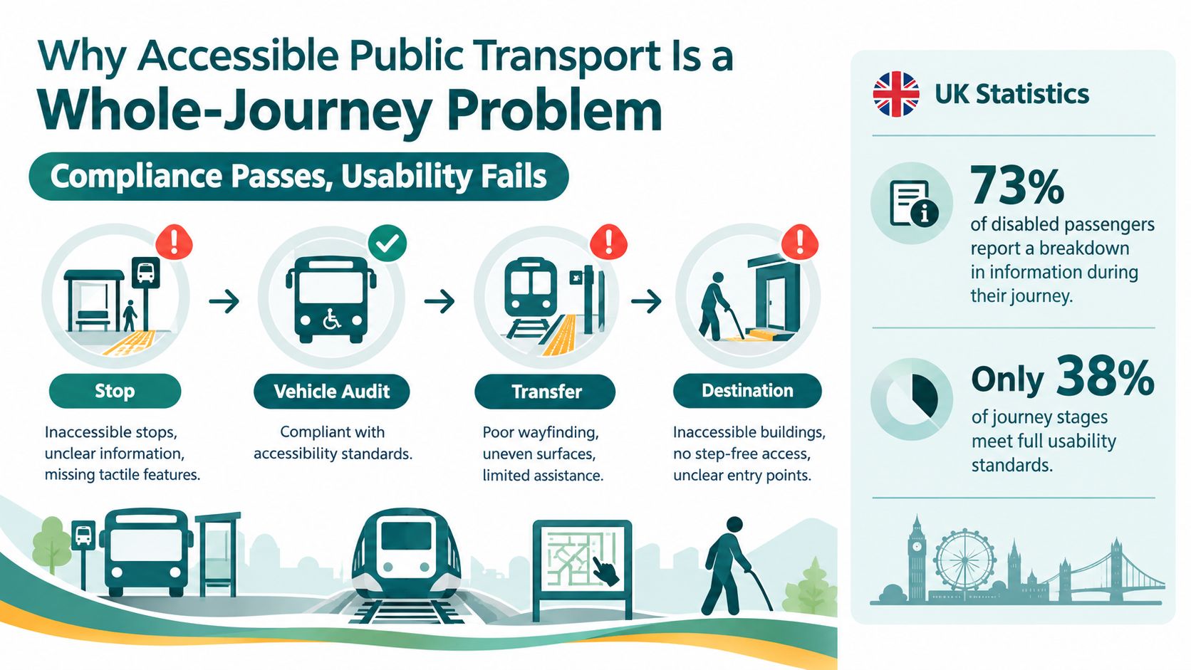
A wheelchair user can board a technically accessible railcar and still become stranded when the step-free route disappears between the platform and concourse. A blind passenger can reach a bus stop and still miss the vehicle because the stop location, boarding point or disruption information isn't available in a usable format. The vehicle may comply. The journey doesn't.
The UK evidence is unambiguous. A 2024 NCAT report on barriers to accessing transport found that 92% of disabled people in the UK had experienced a barrier on at least one mode of transport. Train users reported the highest level of problems at 91%, while bus users reported 90%, and underground train and air-travel users each reported 80%.
Compliance measures equipment, not usability
England's buses illustrate the gap. As of 31 March 2020, 99% of buses were technically accessible, and operators covering all drivers and onboard staff required disability-awareness training, according to the Department for Transport's transport disability and accessibility statistics. Yet disabled adults in England made 28% fewer trips than non-disabled adults in 2020, according to the same DfT series.
Rail presents a similar problem. 92% of heavy rail vehicles in Great Britain were accessible at 31 December 2019, but vehicle data couldn't tell passengers whether every platform, interchange or station route was usable. The Office for Statistics Regulation review of transport disability statistics identified the need for station-level, geographical and disability-specific data.
Operational rule: Treat every accessibility promise as a journey-stage promise. “Step-free station” is incomplete unless the operator can describe the route from street to platform, the current lift status, the staff handoff and the alternative when something fails.
The missing layer is informational. Passengers need current data about staff availability, cancellations, lift outages, platform changes, stop conditions and the final approach to the destination. The Waymap analysis of public transport directions reflects the same principle. Static labels don't provide dynamic, end-to-end access.
This creates operational and legal exposure under the Equality Act 2010 and the Accessible Information Regulations. It also creates avoidable service failures, missed connections and lost trips. Audits often stop at the station entrance. Accessible public transport must account for the last 100 metres, the transfer and the exact destination.
Auditing Your Network for Real Accessibility Gaps
Start with an audit that follows people, not assets. A conventional equality impact assessment may record whether a lift exists, but it won't necessarily show that the lift opens onto an obstructed corridor, that a kerb cut floods, or that staff direct passengers to a route that has changed.
Use a mixed discovery process with disabled passengers involved from the beginning. A DPTAC-style access panel can challenge assumptions, while mystery-shopper exercises expose the difference between written procedures and frontline reality. The Waymap guide to accessibility testing is useful context for structuring testing around actual tasks rather than abstract conformance.
Four audit activities produce better evidence
Assemble an access panel. Include wheelchair users, blind and partially sighted passengers, people with hearing loss, people with cognitive disabilities and older passengers. Pay participants for their expertise and test both routine and disrupted journeys.
Map the complete route. Record the pavement, kerbs, crossings, stop or station entrance, ticketing area, platform, vehicle, interchange and final destination. Log thresholds, platform edges, confusing junctions, poor lighting, inaccessible toilets and places where a passenger must ask for help.
Run observed journeys. Ask participants to complete realistic tasks while auditors record what information they have, where they hesitate and what happens when an expected facility is unavailable. Desk reviews rarely capture the hidden barrier created by an unclear handoff.
Rank failures by consequence. A blocked doorway on a secondary route isn't equivalent to a missing step-free path to the only accessible platform. Score each issue against frequency, journey criticality, available workaround and impact on independence.
The UK Parliament transport accessibility survey identified the street environment as the accessibility challenge affecting the highest number of respondents across the modes studied. It also recorded 356 of 825 respondents saying physical inaccessibility of stations, vehicles or other infrastructure caused issues most of the time or always.
The audit must produce procurement artefacts
A board-ready audit should leave the organisation with:
- A failure-zone heat map: Show where access breaks down, including the approach to stops and stations.
- A dynamic-data inventory: Record which systems publish lift status, platform changes, assistance availability and disruption updates, and identify the gaps.
- An accessibility gap register: Assign each issue an owner, severity, remedy, timescale and funding route.
- A user-test record: Preserve the journey task, participant perspective, observed failure and agreed response.
- A standards crosswalk: Map findings against BS 8300-2, the Equality Act 2010 and relevant information obligations.
This evidence lets procurement teams distinguish between a capital project, an operational fix, a data integration problem and a navigation requirement.
Comparing Infrastructure-Based and Infrastructure-Free Wayfinding
Physical infrastructure remains valuable. Tactile paving, embossed signs, clear colour contrast and audible announcements provide familiar, resilient cues. Beacons can offer precise local positioning in some dense terminals. None of these layers solves every journey condition, and none should be removed because a digital alternative exists.
The procurement mistake is treating the choice as either physical infrastructure or software. The stronger model combines durable environmental design with a dynamic navigation layer that can account for changed routes, unavailable lifts and exact destinations.
Waymap uses dead reckoning from device-native motion sensors, rather than GPS, Wi-Fi or installed hardware. Its stated capability includes sub-3-metre accuracy in infrastructure-free environments, with no pre-mapping requirement for venues where staff turnover or layouts make installed equipment difficult to maintain. That makes it relevant to signal-poor underground environments, but agencies should validate performance on their own routes and with representative users.
Navigation without GPS explains the infrastructure-free approach in more detail. The decision should still reflect the network's physical conditions, data maturity and capital horizon.
| Dimension | Beacons | Tactile / Signage | Infrastructure-Free Navigation |
|---|---|---|---|
| Positioning | Can provide strong local accuracy where devices are installed and maintained | Provides physical orientation cues, not continuous route computation | Uses smartphone motion sensors and detailed maps without installed positioning hardware |
| Capital requirement | Requires hardware procurement, installation and replacement planning | Requires construction or retrofit work | Requires mapping, software integration and operational ownership |
| Adaptation | Hardware may need repositioning when layouts change | Static, so it can't reroute around closed facilities | Routes and points of interest can be updated digitally |
| Signal environment | Can be affected by station materials, interference and device condition | Doesn't depend on wireless signals | Designed for indoor, outdoor and underground use, subject to local validation |
| Best use | Fixed zones where precise installed positioning justifies maintenance | Baseline environmental accessibility | Dynamic, end-to-end guidance that complements physical infrastructure |
Use a decision matrix before selecting a supplier
Choose beacons when a high-value, stable zone needs installed positioning and the operator can fund maintenance. Choose tactile and signage improvements when the audit identifies a physical cue or orientation deficit. Choose infrastructure-free navigation when the priority route crosses multiple environments, when signal coverage is unreliable, or when layouts and operational conditions change faster than physical assets can be updated.
The sensible answer is often layered. Physical access enables movement. Digital navigation explains the route, responds to disruption and takes the passenger to the exact door, platform or point of interest.
Designing Staff Training and Inclusive Wayfinding
Technology won't compensate for staff who don't know how to respond when a passenger's planned route fails. Frontline competence is the operational layer between an accessibility policy and a usable journey.
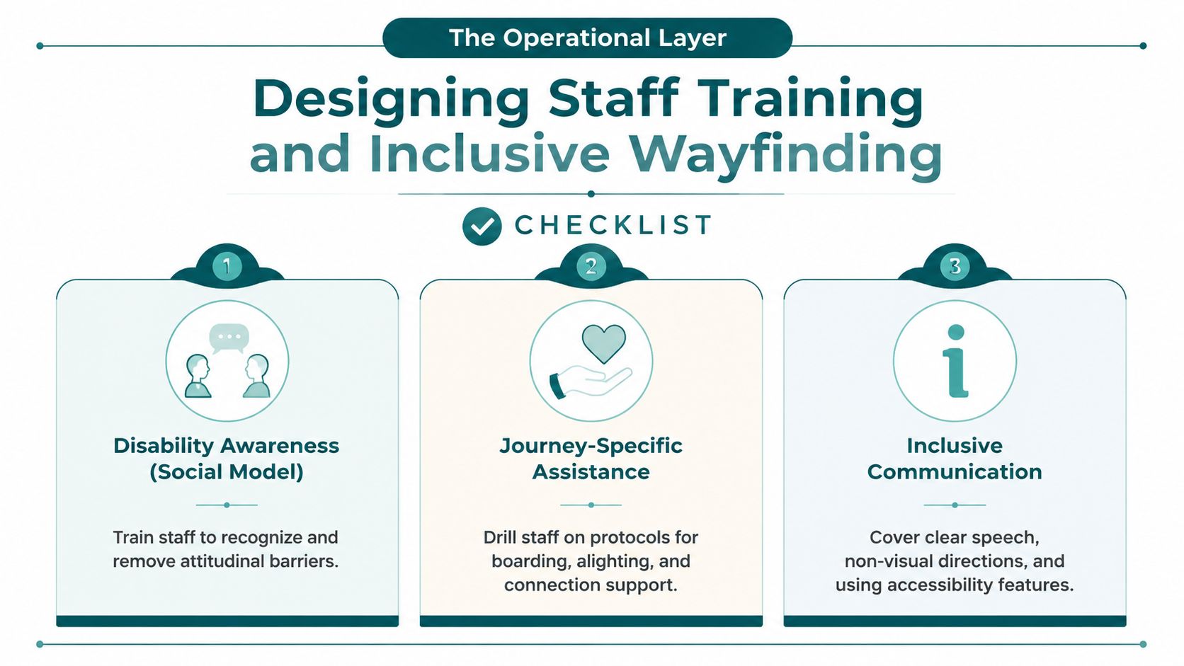
Train staff around the Social Model of Disability. The focus is not on what a passenger supposedly cannot do. It's on removing barriers created by the environment, information, processes and attitudes. Staff should know how to offer assistance without taking control, communicate clearly, describe non-visual routes and preserve the passenger's chosen method of travel.
Train for the situations that create failure
Build exercises around real operating conditions:
- Disability awareness: Practise respectful communication, consent, orientation and assistance for different access requirements.
- Journey-specific assistance: Rehearse boarding, alighting, platform changes, missed connections and handoffs between teams.
- Disruption interpretation: Teach staff to read lift, gate, platform and route-status data before giving directions.
- Inclusive communication: Require clear speech, non-visual descriptions, written alternatives and accessible digital updates.
The UK Government's Inclusive Transport Strategy anchors the sector's wider duty to provide equal access. The Accessible Information Regulations for local bus and coach services in Great Britain took effect on 1 October 2023, with compliance phased according to vehicle age. Vehicles first used on or after 1 October 2019 had to comply from 1 October 2024, while partially compliant vehicles must comply from 1 October 2031, as set out in the Government guidance on onboard accessible information.
Put dynamic information into the passenger layer
Printed timetables and fixed signs remain necessary, but they can't communicate a lift outage or temporary diversion. Agencies should integrate live operational feeds into existing journey planners through GTFS, open APIs or equivalent interfaces, then expose the information through audio, high-contrast screens and accessible mobile interactions.
A procurement requirement can be direct:
Require the supplier to provide accessibility conformance reporting, document assistive-technology compatibility, expose route and facility-status data through an agreed interface, and demonstrate disrupted journeys with disabled participants before acceptance.
The Waymap material on staff training requirements supports this operational emphasis. The platform can provide step-by-step audio or on-screen directions from street level to platforms and points of interest, but the operator still owns the quality of its underlying data and staff response.
Measuring Success With Operational Accessibility KPIs
A station label tells you that a lift exists. It doesn't tell you whether the lift worked during a passenger's journey, whether the route planner sent them to it, or whether staff provided a usable alternative after failure.
Measure outcomes using feeds the agency already operates. Automatic vehicle location systems, lift-monitoring systems such as OTIS interfaces, help-point logs, assistance-booking records and app telemetry can create a practical accessibility dashboard without building an entirely separate reporting estate.
Five measures belong on the monthly scorecard
- Assistance journey completion: Track whether registered assistance users completed the planned journey, including any handoff or connection.
- Disruption alert time: Measure the time between an operational change and an accessible passenger notification.
- Lift availability: Compare scheduled service periods with confirmed operational availability, then segment by station and route.
- Step-free routing accuracy: Test whether the journey planner's recommended route remains usable under current facility conditions.
- Assistance response time: Record the interval between a request and staff acknowledgement or arrival.
| Metric | Legacy Compliance Label | Operational KPI |
|---|---|---|
| Lift | Lift present | Availability during the passenger's travel window |
| Route | Step-free route published | Route accuracy under current conditions |
| Assistance | Assistance offered | Response time and journey completion |
| Information | Accessible announcement installed | Time to deliver usable disruption information |
| Vehicle | Accessible vehicle recorded | Successful boarding and alighting on the planned service |
Use cohort comparisons to identify whether outcomes differ by disability type, route, time of travel or interchange. Test lift failures against missed connections and incomplete journeys rather than reporting only the number of repairs. The Waymap compliance reporting system resource reflects the shift from static declarations to evidence that can support operational decisions.
Avoid vanity metrics such as app downloads or training attendance unless they connect to passenger outcomes. A useful dashboard should tell an operations director which failure requires an engineering fix, which requires better data and which requires staff intervention.
Named Deployments That Prove Infrastructure-Free Navigation Works
Named deployments matter because procurement decisions turn on constraints, not slogans. A transit agency needs to know whether a system works underground, across an interchange or in a venue where installing and maintaining hardware would delay delivery.
Waymap has worked with WMATA in Washington, DC, where the relevant challenge is navigation across a public transport network that includes underground stations, rail platforms, bus stops and bus routes. GPS isn't dependable underground, and an operator can't assume that a passenger can identify the correct entrance, platform direction or surface exit from static information alone. An infrastructure-free navigation layer addresses that transition from street to station and supports the accessibility objective associated with ADA Title II, while leaving the agency's physical access responsibilities intact.
SBS Transit in Singapore represents a different operating environment. Bus and rail interchanges require passengers to move between modes, and a mature estate makes universal physical retrofit expensive and disruptive. Infrastructure-free guidance can supply a digital layer across those handoffs without requiring every route to receive new beacons or extensive tactile changes. The relevant policy context includes Singapore's Enabling Masterplan, but the procurement case remains practical: provide usable directions across the interchange while preserving existing infrastructure.
At Lord's Cricket Ground, the operator problem is venue navigation across entrances, concourses, stairs and step-free routes. A visitor may know the stadium address and still need guidance to a particular gate or accessible facility. Smartphone-based navigation can support that final approach and internal movement without requiring a permanent positioning installation throughout the venue.
These examples don't remove the need for clear signage, tactile information, staff support or reliable data. They show where infrastructure-free navigation fits: underground routes, multi-modal transfers and high-change venues where a dynamic layer can be deployed without waiting for a full physical retrofit.
For venue operators, the duty extends beyond regulatory compliance. The Equality Act 2010, ADA Title III and standards such as BS EN 17210 all reinforce the need to consider access in the built environment. A procurement team should connect each deployment to a defined failure point, a tested journey and an outcome KPI, rather than treating a named customer as proof of universal performance.
Your 90-Day Accessibility Implementation Plan and FAQ
A practical programme can reach a defensible pilot decision within a short delivery window if the board agrees the problem first. Use four two-week sprints, then reserve the remaining period for implementation, testing and baseline measurement.
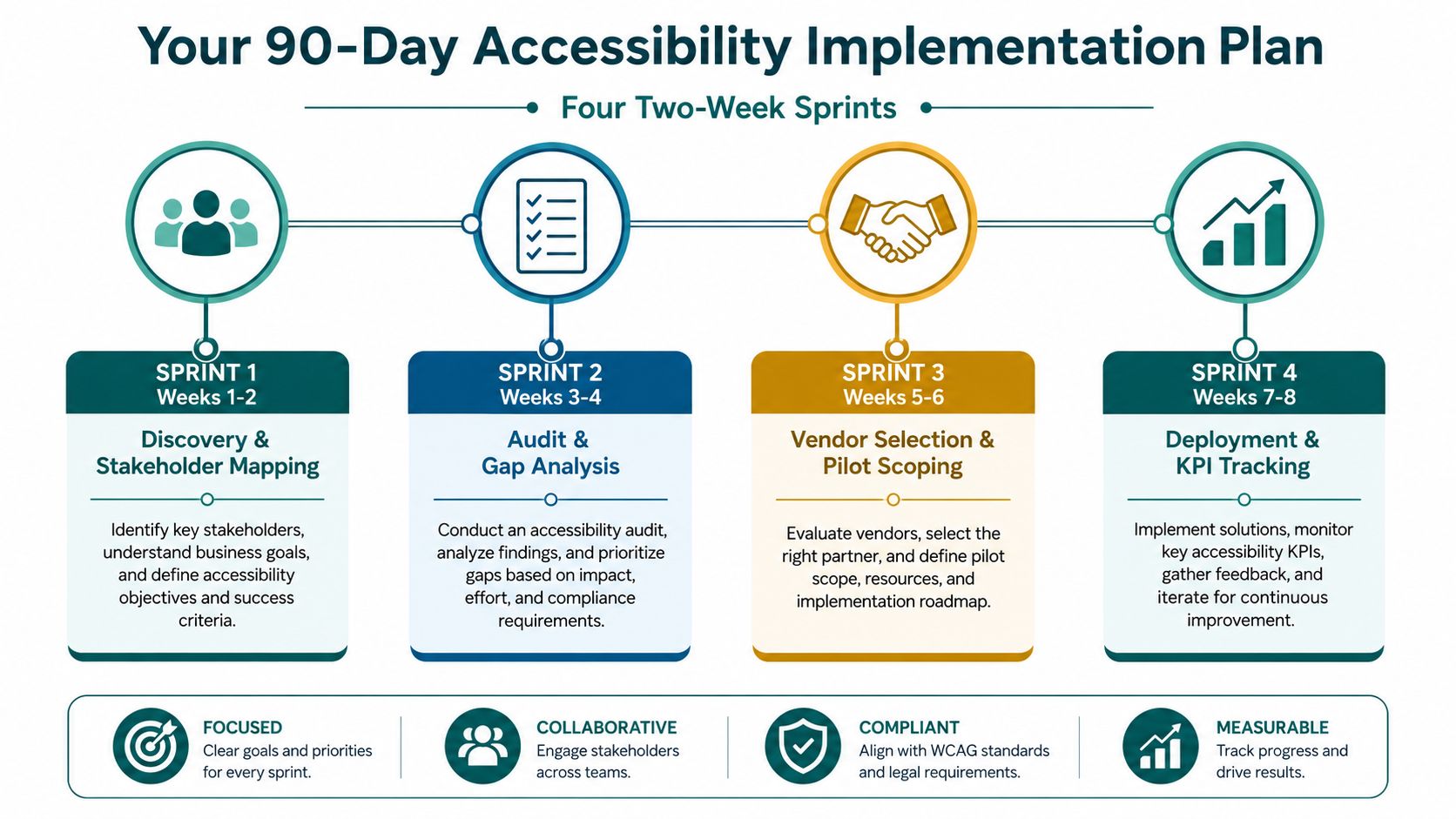
- Weeks 1 to 2, discovery and stakeholder mapping: Name the executive owner, accessibility lead, data owner, operations lead and disabled-user panel. Deliver a journey shortlist, risk statement and decision criteria.
- Weeks 3 to 4, audit and gap analysis: Walk priority routes with disabled participants. Deliver the failure heat map, dynamic-data inventory, accessibility gap register and standards crosswalk.
- Weeks 5 to 6, vendor selection and pilot scoping: Compare physical and infrastructure-free options against signal conditions, capital constraints, data readiness and maintenance ownership. Define acceptance journeys and accessibility conformance evidence.
- Weeks 7 to 8, deployment and KPI tracking: Configure the pilot, test routine and disrupted routes, train frontline staff and establish the baseline for completion, alert time, lift availability, routing accuracy and assistance response.
- Remaining delivery period: Review evidence with the access panel, correct route or data defects, and present the board with a scale, amend or stop recommendation.
Agencies without internal capacity can also review specialist accessibility management for agencies to clarify governance, testing and reporting responsibilities before procurement begins.
How accurate is infrastructure-free navigation indoors and in signal-poor zones?
Waymap describes a dead-reckoning approach using device-native motion sensors, with sub-3-metre accuracy in infrastructure-free environments. Procurement teams should require route-level validation in underground stations, metal-heavy buildings and complex interchanges, using disabled participants and the same completion and routing-accuracy measures that will govern acceptance.
What does it cost compared with beacon rollouts?
The answer depends on the estate, mapping requirement, integration scope and physical retrofit already planned. Infrastructure-free navigation removes the need to install and maintain positioning hardware, but it still requires accurate maps, data integration, testing and operational ownership. Compare total cost of ownership, not just the initial supplier price.
How does it support Equality Act 2010 and Accessible Information Regulations 2023 duties?
It supports those duties by improving access to usable route information and by helping operators communicate changing conditions. It doesn't replace accessible vehicles, step-free infrastructure, staff assistance or legal advice. The operator must connect the navigation service to current facility and disruption data, then test it with disabled passengers.
Can it integrate with existing journey-planner apps?
Yes, integration should be a procurement requirement rather than an afterthought. Specify the required interfaces, route data, facility-status fields, accessibility conformance reporting and fallback behaviour when live data is unavailable. The acceptance test should follow a complete journey from street level to platform, vehicle and destination.
What equity safeguards prevent algorithmic bias in routing?
Use co-design and route testing across disability groups, not a single representative user. Log inaccessible recommendations, compare results across journey types and require a human escalation path when data is incomplete. The operator should publish how it handles uncertainty, temporary closures and routes that depend on staff assistance.
Accessible public transport succeeds when agencies measure what passengers experience, not only what assets they own. Start with the last 100 metres, connect operational data to inclusive wayfinding and make disabled passengers part of acceptance testing from the first sprint.
Waymap provides infrastructure-free, step-by-step navigation across indoor, outdoor and underground environments, including guidance to exact entrances, platforms and points of interest. Visit Waymap to discuss a pilot that connects your accessibility audit, operational data and whole-journey navigation goals.
