
Wolverhampton Coach Station: Complete 2026 Guide
You step off a coach, look around for the right exit, and the first question hits immediately. Is this Wolverhampton Coach Station, where does it connect to the rail station, and how do you move through the interchange without wasting time? This guide to Wolverhampton Coach Station answers that from the point of view of a Waymap practitioner who has walked the site, used the station, and looked at the transfer points travellers depend on.
Arriving at Wolverhampton Coach Station
The first impression is practical rather than dramatic. You arrive into a central transport environment that feels tied into the city rather than separated from it, with coach travel sitting inside Wolverhampton's wider interchange zone and not at the edge of town. National Express identifies Wolverhampton as a coach station, and the nearby rail hub's modern redevelopment under a £150 million investment scheme completed in June 2021 shows how much of the area has been reworked recently. best free navigation app
That matters because the experience is shaped by transfer, not just arrival. If you're heading on to rail or local bus services, the station sits in a transport core that has been reorganised for decades, so the useful question is not “Where's the coach station?” but “Which exit, which walkway, and which next mode do I need?” The rest of the guide follows that logic.
For travellers with accessibility needs, the key point is that the interchange is busy, layered, and mostly understandable once you know the landmarks. The difficult part is the micro-navigation, the short transitions between doors, concourses, and waiting areas. That's where journey planning either helps or leaves people guessing.
Practical rule: if you can identify the rail station first, you can orient yourself to the coach and bus facilities much faster than trying to read the whole interchange at once.
Where Wolverhampton Coach Station Sits in the City
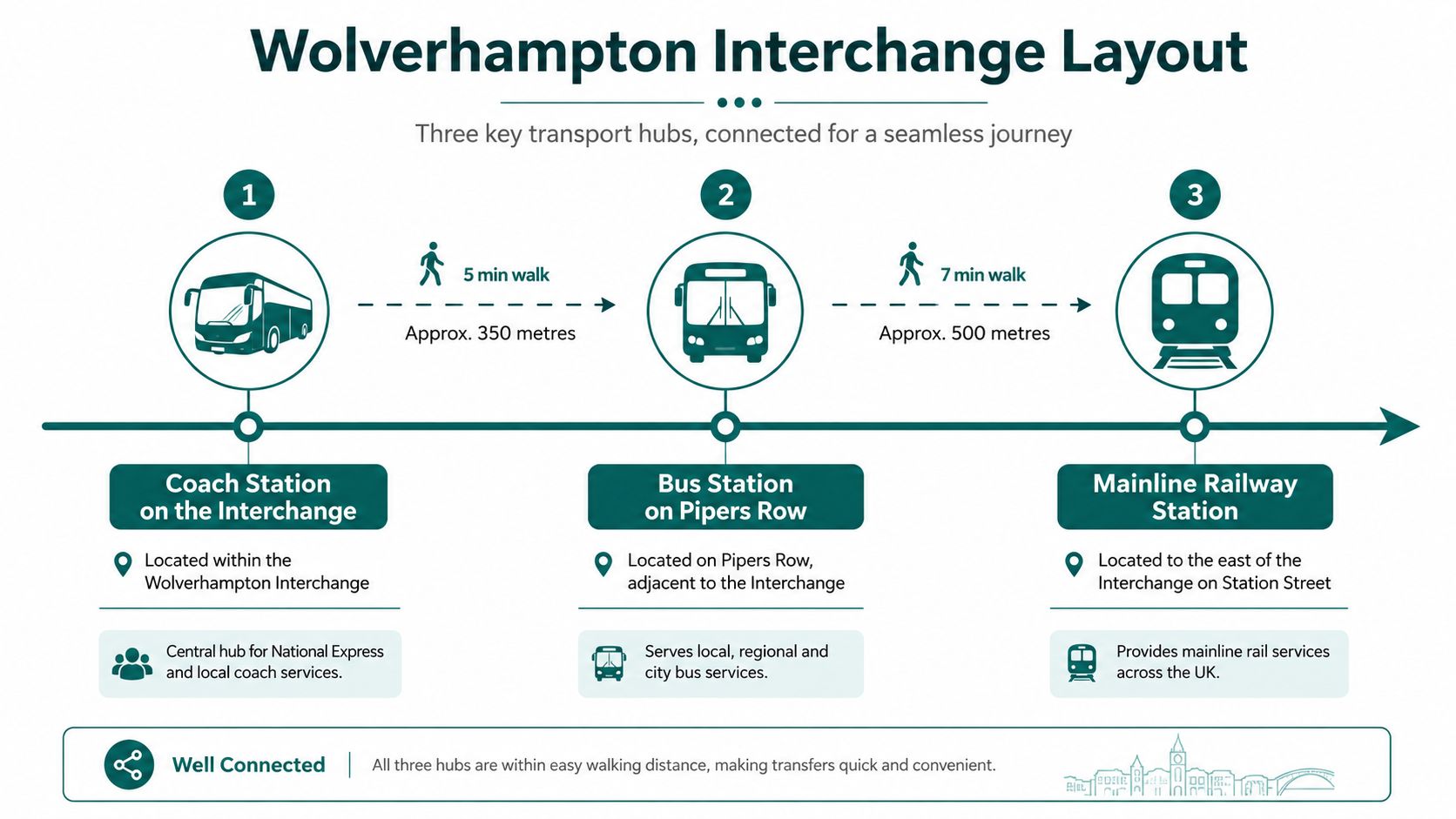
Wolverhampton Coach Station sits inside a long-established interchange zone that also includes Wolverhampton Bus Station and the mainline Wolverhampton railway station. The coach facility is not a stand-alone out-of-town terminal, it belongs to the same central transport cluster that has been repeatedly rebuilt as the city's movement patterns changed. Bidwell buyer profiles is useful context if you want to understand how city-centre transport assets like this are evaluated by local decision-makers.
The site's transport history explains the layout
The chronology matters. Wolverhampton's public transport network goes back a long way, with trolleybuses operating from 1923 until 1967, and rail services dating to 1837 with the current main station opening in 1852. The original bus station on the interchange site was replaced in 1980, then again in 1986, before that station closed after services finished on 3 April 2010. Wolverhampton bus station history
That sequence is why the coach station feels embedded in a historic transport node rather than bolted on later. The present rail station site opened on 1 July 1852 as Wolverhampton Queen Street, while Wolverhampton Low Level opened on 1 July 1854 and later closed to passengers in 1972. The result is a city core where rail, bus, and coach access have been repeatedly reshaped in the same small area.
What to aim for when you get off
If you're arriving for the first time, orient yourself to the railway station first, then look for the coach and bus links around the same interchange. The main pedestrian movement is between the coach stop, the bus station on Pipers Row, and the rail station area, so you should expect a short urban walk rather than a long transfer.
The city centre ring road is close enough that the interchange feels part of the central core, not a separate district. That proximity is useful for travellers and for accessibility planning, because it means short walks matter more than long vehicle transfers. If you're briefing a city team, the most useful read on the transport role is the West Midlands Combined Authority client context, because it sits neatly alongside the interchange's real-world geography.
Coach Operators and Typical Routes
National Express is the principal long-distance operator at Wolverhampton Coach Station, and that's the service most travellers will book first. The station code context also matters here, because Wolverhampton station carries the code WVH in official passenger data, which helps anchor rail and coach interchange planning in the same city-centre node. Real-time transit information
What kinds of journeys to expect
The usual long-distance corridors are the ones travellers already look for in coach search tools, especially London, Birmingham, Manchester, and airport links. Those are the routes that make Wolverhampton useful as a regional connector rather than just a local stop. Services berth at the coach station when they're part of the scheduled long-distance network, while some other pickup patterns can sit on surrounding streets depending on operator and timetable design.
That split is important. If you're comparing options, don't assume every coach leaves from exactly the same bay or street position, even within the same city centre. Booked journeys can vary in stop pattern, and passengers who plan only by operator name can still end up standing in the wrong part of the interchange.
Wolverhampton station's passenger data gives a sense of the scale of the surrounding hub. Official data compiled for the station shows 4,770,990 entries and exits in 2024 and 228,071 interchanges, with a year-on-year rise of 7.3% in entries and exits and 2.7% in interchanges. Wolverhampton station passenger data
The coach station works best when you treat it as part of a busy interchange system, not as a single point on a map. That mindset cuts down on missed connections.
For travellers, the practical takeaway is simple. Use National Express for the main intercity coach market, check the exact boarding point before you travel, and expect the value of the station to come from its connection to rail and bus rather than from a standalone terminal experience.
Walking Between the Coach Station, Bus Station and Rail Station
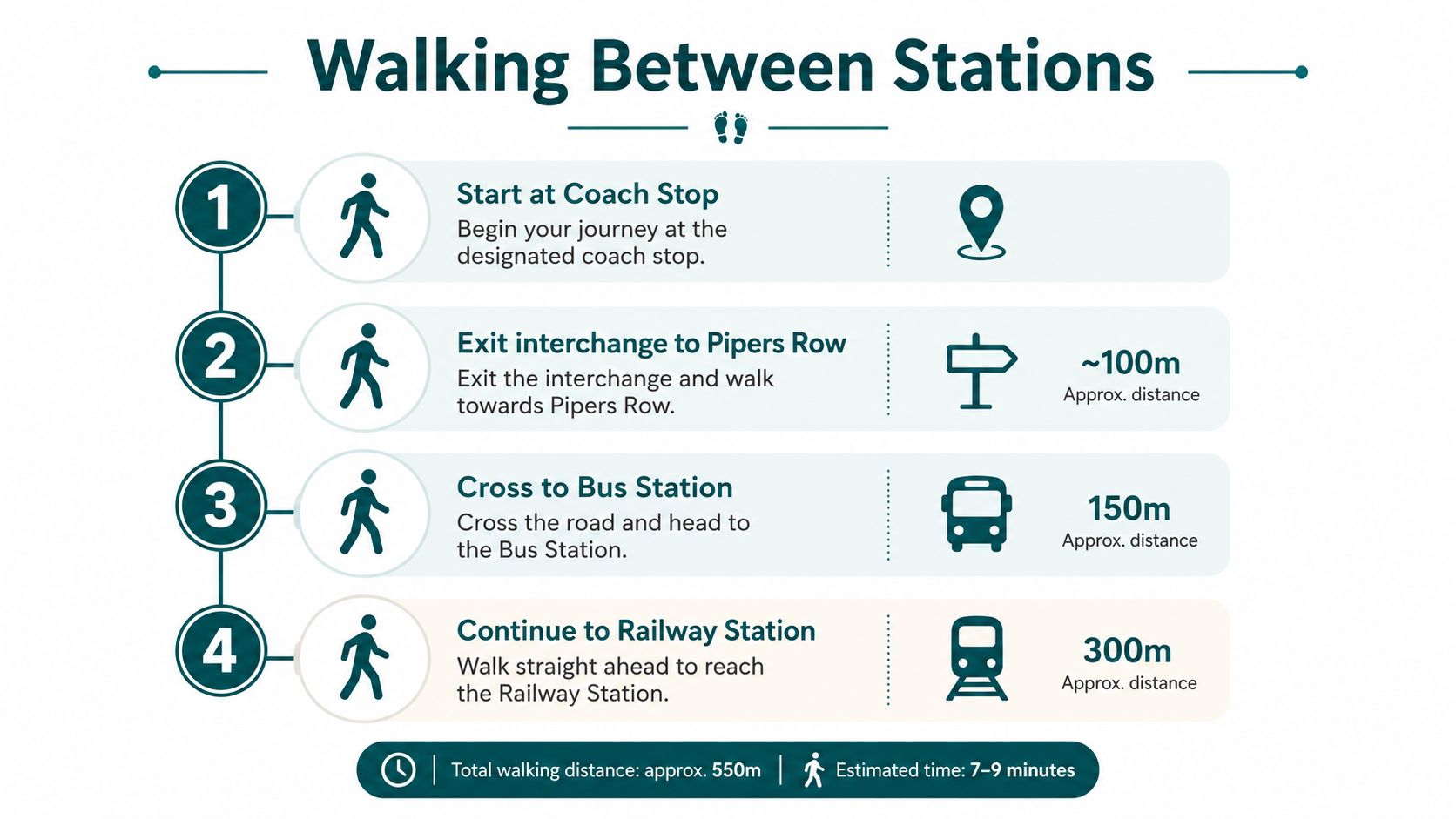
The transfer is short, but first-time visitors often overthink it because the interchange has multiple moving parts. The simplest route is to leave the coach area, follow the pedestrian flow towards Pipers Row, and then continue on towards the rail station entrance. Train station floor plan
Step by step on foot
Start at the coach stop. Pause long enough to spot the exit that leads back into the interchange, rather than following the first queue you see.
Exit towards Pipers Row. This is the key orientation point for the bus station, and it's where people often stop to check which side of the road they're on.
Cross to the bus station. The route is short and direct, and the bus station's accessible entrance is the landmark you want to identify before continuing.
Continue to the railway station. Keep heading towards the main station front and look for the main entrance on Railway Drive. If you're using tram connections, the West Midlands Metro stop is part of the same wider travel environment.
Common mistakes to avoid
The biggest mistake is assuming the coach berth, bus station entrance, and rail entrance all line up in one straight sightline. They don't. People also tend to move too quickly past the decision points, which is a problem if you need lift access, a quieter route, or time to confirm the correct platform or bay.
If you need a calm transfer, stop at each landmark and confirm the next one before you move on. That approach is more reliable than trying to follow crowd flow alone, especially at peak arrival times.
Accessibility Features and Gaps at the Interchange
A coach traveller arriving at Wolverhampton often meets the same problem before they ever reach the building, the interchange is physically usable, but the route between its parts is still too easy to misread. That matters here because the station sits inside a wider upgrade programme, and the coach side of the interchange has not been documented with the same care as the rail side. In practice, the missing piece is the micro-navigation layer, the small-scale guidance that tells someone which entrance, threshold, bay, or crossing to use at the exact point they need it.
Wolverhampton station itself gives the interchange a strong base. National Rail classifies it as step-free category A with step-free access to all platforms, lifts, accessible toilets, Changing Places toilets, and help points inside and outside the station. Avanti also states that lift door widths are at least 1.1 m and that there are 16 accessible car-park bays. Wolverhampton station accessibility
The bus station side is also well served. The WMCA access guide says the station interchange has tactile paving, automatic announcements, an accessible toilet, and Blue Badge spaces. Those features give travellers real choices, especially when they can combine audio, tactile, and step-free access with a bit of advance planning. Wolverhampton bus station accessibility
What still falls short is wayfinding at the level people use it. Public information is split across operators, and the questions that come up on the ground are specific, where do I enter, which path avoids the wrong kerb or barrier, and how do I get from the coach berth to the rail platform without losing confidence halfway. That gap is exactly what infrastructure-free navigation platforms were built to close, because the need is not only for accessible infrastructure, but for readable access in a changing environment. A practical version of that approach is set out in our inclusive design principles.
The policy frame is clear. The Equality Act 2010 and BS 8300 both push estates and transport teams towards usable access, not just nominal access. For a high-footfall interchange, that means the challenge is not only installing the right features, it is keeping them legible and current as layouts, operators, and boarding points change. That principle is reflected in our commitment to accessibility.
Accessibility is not finished when the lift works. It's finished when a traveller can find the lift, reach it, and understand the route without asking three different staff members.
For team leads, the trade-off is maintenance. Every fixed hardware layer adds operational burden in a busy interchange, and every change to the physical site can leave a previous sign, route, or notice out of date. That makes clear digital guidance stronger whenever the built environment is already complex.
Tickets, Parking, Taxis and the Metro
If you're arriving with luggage, the practical questions are usually about tickets, where to wait, and how to leave quickly once you've stepped off the coach. West Midlands Railway says the ticket office is open Monday to Saturday from 05:30 to 22:30 and Sunday from 07:30 to 21:15, with ticket machines on the main concourse and the Customer Information Lounge open during station opening hours. Wolverhampton station ticket office
What to do on arrival
If you're switching to rail, use the concourse ticket machines unless you need staff support, then head straight for the station information point if you're unsure about platform changes. If you're staying with coach travel, pre-booking is still the safer choice because it gives you the clearest idea of where you should be waiting and when.
For onward transport, the taxi rank sits outside the railway station area, which makes it the most straightforward option for travellers with luggage or mobility needs. The National Express car park serves drivers using the interchange by car, while the West Midlands Metro stop gives you a public-transport link into Wolverhampton city centre and towards Birmingham.
How to keep the transfer calm
On a busy day, the best tactic is to choose your next mode before you leave the coach bay. That keeps you from drifting between signs, especially when the bus station, rail concourse, and Metro environment are all pulling your attention in different directions.
- Need a taxi: head for the rail-station side rather than wandering the bus area first.
- Need the Metro: follow the tram signage from the interchange rather than trying to infer the stop from vehicle noise.
- Need local bus services: check the bus station displays and look for the boarding point before you queue.
- Need time to regroup: stay near the concourse or a clearly marked waiting area instead of standing in the middle of the transfer route.
The station works best when you use the right facility for the right job. Ticket office for staff help, machines for speed, taxi rank for luggage, Metro for city and Birmingham links, and the coach station for booked intercity travel.
How Infrastructure-Free Navigation Changes the Interchange
Wolverhampton is exactly the kind of interchange where static signage can do only part of the job. The layout is layered, the transfer routes are short but decision-heavy, and the accessibility gap is about finding the right door at the right moment, not about understanding the city at large. That is where infrastructure-free navigation earns its place.
Waymap's model uses dead reckoning from the smartphone's motion sensors, without relying on GPS, Wi-Fi, or Bluetooth beacons, and it is designed to provide sub-3-metre accuracy in infrastructure-free environments. For a place like Wolverhampton, the value is less about novelty and more about keeping the digital guidance layer adaptable when operator information, boarding points, or indoor routes change.
Why that matters for transport teams
The operational burden is real. Transport and estates teams already manage high footfall, changing layouts, and the need to keep accessible routes current, so adding more physical hardware can become a maintenance job in its own right. That is especially true where access obligations under PAS 78 and the Equality Act 2010 push teams to do more than publish a static map.
Comparable transit deployments such as WMATA, SBS Transit, and LTA Singapore show why this model has traction in live transport environments. The lesson for Wolverhampton is straightforward. A layered interchange needs a wayfinding system that can be updated as quickly as the physical environment changes, without requiring a new hardware round every time the route picture shifts.
What makes the approach useful for travellers is the lower-friction experience between the coach berth, the bus station, and the rail front door. What makes it useful for operators is that the guidance layer can be updated digitally rather than rebuilt physically. In a place like Wolverhampton, those two gains line up neatly.
Practical Tips and Common Questions for Travellers
Arrive a little early if you're changing modes, because the transfer through Wolverhampton is short but not instant. If you want a comfortable wait, use the rail concourse, the bus station facilities, or a clearly signed waiting area rather than standing where the pedestrian routes split. If your coach is delayed, check the operator's live information first, then hold position near the berth until the new timing is clear.
For city centre visits, the station works well for the Molineux Stadium, Wolverhampton Art Gallery, and the University of Wolverhampton, but each needs its own final walking or bus leg. Bookmark the live tools that matter most, National Express coach tracking, National Rail live departures, and the West Midlands Network journey planner, because those are the ones that reduce guesswork when the day changes. The best search term many travellers use is still Wolverhampton Coach Station, but the best habit is checking the exact onward route before you move.
If you manage transport access, campus navigation, or a city-centre interchange, Waymap gives you a practical way to close the micro-navigation gap that static maps leave behind. It's built for exact, step-by-step guidance in places like Wolverhampton Coach Station, where the challenge is the transfer, not the destination. Visit Waymap to see how infrastructure-free navigation can support your travellers and your accessibility team.
