
Voice Navigation App Guide: How It Works and Who Needs It
You are at the entrance, and the outdoor map has already finished its useful work. The next instruction has to put someone at a platform, a lift or a stadium gate, not at a postcode. If you run a station, a hospital or a ground that refits between events, you already know that a pleasant voice is not the hard part. A voice navigation app only holds up when its positioning still works after GPS drops and the layout is no longer the one from last season.
Written by Tom Pey, Founder of Waymap and a blind accessibility technologist who built the product.
What a Voice Navigation App Does and How It Guides You
A visitor at Lord's Cricket Ground reaches the correct gate and hears the next instruction through an earbud, with both hands free. A voice navigation app turns a route into spoken, step-by-step instructions the user can follow without looking at the screen.
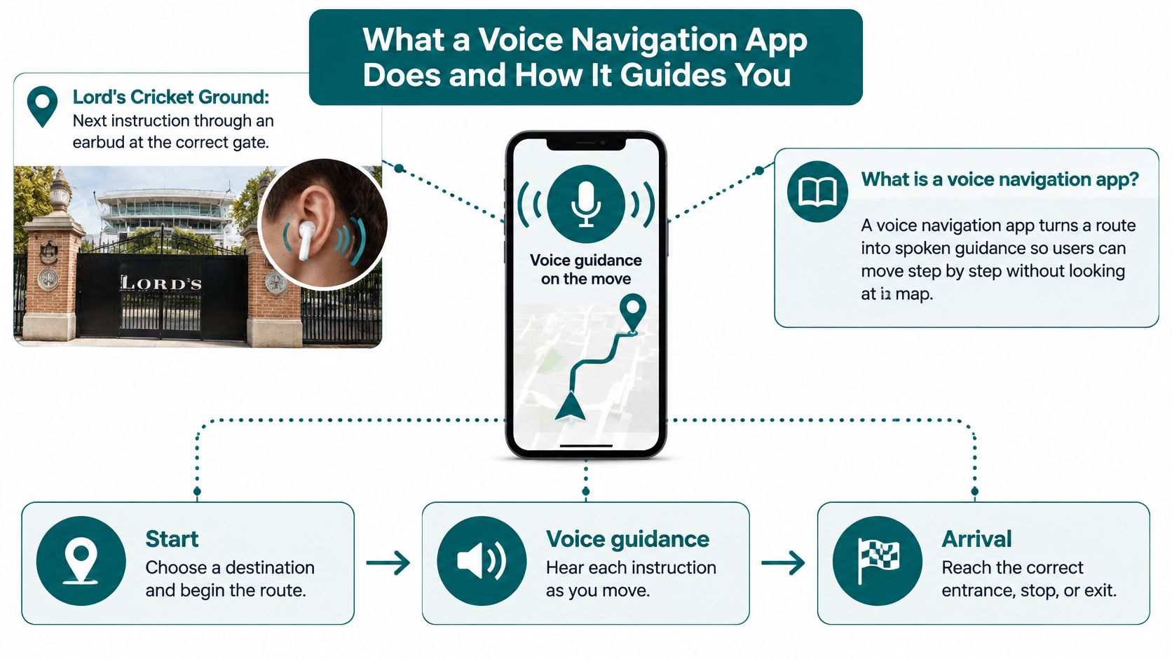
Every useful app is built from three parts, and a weak one of them sinks the journey.
A map of the place. Seats, doors, lifts, platforms and exits have to exist as data. Without that, the voice can only point at a building.
A position estimate. On an open street, satellite positioning is enough. Under a stand or in a concourse, the app needs another way to know which door you are facing.
An output channel. We give the same journey as audio guidance and as on-screen visual directions, and those instructions are available in multiple languages. A hearing user can glance at the screen. A user who cannot read the sign can keep the phone in a pocket.
Who that audio channel is for
The Department for Transport reported that 16.7 million people in the UK were disabled in 2024/25, representing 25% of the population, in its equality impact assessment on accessible bus information. That assessment states that accessible information matters for people with visual, hearing, cognitive and some neurodivergent impairments because it can support safe, confident and independent travel. Spoken guidance is a second channel when signs are dense or hard to read, not a product only for blind users. Our note on navigation built for blind and low-vision travellers is where that founding use sits.
Waymap began as a personal navigation app for people with vision impairment, built around what navigation would be like if it worked for people who are blind.
Before you adopt any audio navigation app, check four things.
- Spoken instructions: Each step must be clear with the screen locked.
- Landmark cues: Name the barrier, door or lift, not only a distance.
- Indoor coverage: Guidance has to continue after the street entrance.
- Offline operation: The next instruction should still play when the signal fails.
If any one of those four is missing, the app is a map with a speaker, not guidance you can trust at a gate.
How Positioning Methods Compare for Hands-Free Guidance
A hands-free navigation app is only as good as the positioning method beneath the voice. At a platform edge, a lift lobby or a stadium gate, that method decides whether the next instruction arrives at all. Hardware, signal needs and upkeep differ sharply by approach.
| Method | Installed hardware needed | Works without GPS or Wi-Fi | Main limitation | Best fit |
|---|---|---|---|---|
| GPS | None | No | Signal weakens inside buildings and underground | Open streets and road legs |
| Wi-Fi positioning | Surveyed access points | No, depends on Wi-Fi | Needs network coverage and survey upkeep | Offices with dense Wi-Fi |
| Bluetooth beacons | Beacons fitted and maintained | Yes, once beacons are in place | Hardware cost, power and relocation after layout changes | Fixed venues with stable layouts |
| Sensor fusion (Waymap) | None | Yes, once app and maps are downloaded | Mapped layout must stay current | Venues and routes where layouts change, with Waymap Pro camera start-point fixing for the exact starting point |
What each method costs you in practice
GPS earns its place on open streets and the road leg of a journey. It needs nothing installed. It also fails where guidance matters most: inside buildings and underground. A station or stadium route cannot finish on GPS alone.
Wi-Fi positioning leans on surveyed access points. It can suit an office with a dense, stable network. Move an access point and the survey has to be repeated. In a concourse that changes for events, that upkeep becomes a poor bargain.
Bluetooth beacons can be reliable once fitted, powered and mapped. Every retail unit, gate line or temporary wall that moves takes a beacon with it. That maintenance lands hardest on venues with frequent refits. Fixed-location rules work on known ground, as a Faberwork geofencing success story shows for vehicle fleets, but they do not transfer to a person walking into a building. That person needs a method that does not depend on fixed kit.
Sensor fusion is the row I would choose where layouts change, staffing is thin or signal is poor. The phone supplies the motion data. Waymap relies on smartphone inertial sensors and AI algorithms rather than GPS, Wi-Fi or installed beacons. Once the app and the maps for a venue or route are downloaded, instructions need no GPS, Bluetooth or mobile signal. Waymap Pro sits inside this method, not beside it. Its camera-based visual positioning uses machine learning to pinpoint the exact starting point. The trade-off is map currency. If a venue changes a route and does not update the map, dead reckoning will follow the old path with confidence. Treat map updates as an operational task, not a one-off install. The wider comparison is in our guide to location positioning.
When positioning drifts, the spoken instruction sends the user to the wrong door. Clear speech cannot repair that. I would start any venue trial with the positioning method, then judge the voice.
Choose beacons only where the layout is stable and the budget covers ongoing maintenance. Choose sensor fusion where the building will not stay still.
How Sensor Fusion Guides You Without GPS or Beacons
A voice-guided navigation app built on sensor fusion does not listen for satellites or beacons. It carries the position forward from a known start, then pins that path to the map.
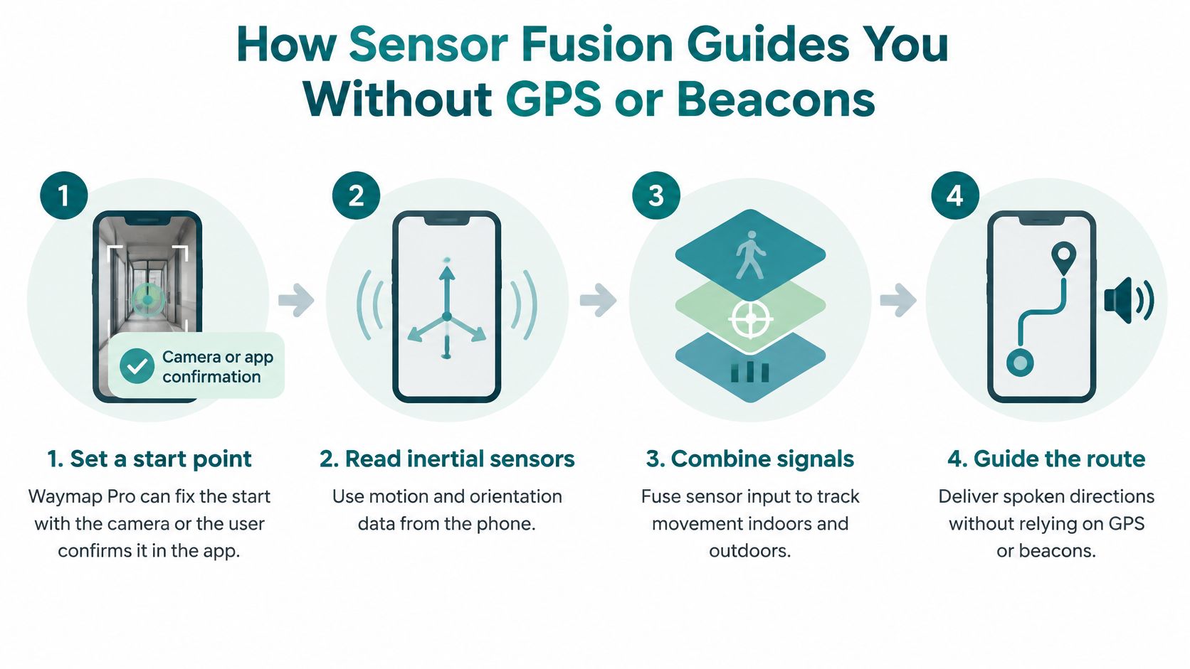
The four stages you should be able to explain
Set a start point. Waymap Pro can fix that point with the phone's camera. Otherwise the user confirms it in the app. A wrong start sends every later sentence to the wrong door.
Read the phone's inertial sensors. Motion and direction sensors detect each step and the heading the user faces. Elevation sensing tracks a change of level, so a ramp and a flat corridor are not treated as the same walk. We use those built-in sensors, the ones that measure movement, direction and elevation, to guide by dead reckoning.
Estimate this person's stride. AI algorithms process the sensor data in real time and estimate step length and direction of travel, so distance comes from that person's stride rather than a generic average. Waymap Core uses AI-powered SmartStep motion-based positioning for that step-by-step track. The result is turn-by-turn voice navigation with no GPS or Wi-Fi.
Match the path to the map. The estimated walk is compared with mapped corridors, doors, stairs, lifts and platforms. A route cannot pass through a wall, so that match pulls a drifting estimate back onto a real passage.
Dead reckoning moves the position forward from the last known point, so small errors build up over a long walk. Map matching is what stops that drift from becoming a wrong platform.
What the user hears is one instruction timed to a landmark. "The lift is the next door on your left" lands better than a bare distance, because the ear cannot re-read a sentence.
On a first walk, verify three things and ignore the rest until they pass.
- The start point: Stand where the app thinks you are standing.
- The first turn: It should match the first real junction, not a later one.
- A deliberate wrong step: The app should correct after you step aside, not keep narrating the old line.
The practical problem this mechanism solves is finding a step-free entrance, a lift or a platform edge without installed hardware. How the fusion is built is set out in our note on the sensor fusion algorithm.
What Makes Spoken Directions Usable Without a Screen
Spoken guidance is heard once and then acted on. A screen can be re-read. An earbud cannot. Every announcement should carry one instruction.
"Turn left after the ticket barrier. The lift is the second door on your right" gives a landmark and a count. "Continue 40 metres" forces the user to pace out a number they cannot see. Give landmarks before metres. Announce a distance only where it helps, such as before a lift door or a platform edge.
When the building changes under the route
If the app is unsure of the next step, it should say so and tell the user what to do. A confident voice on a wrong route is worse than a pause. Reroutes have to be heard before the faulty point, not after the user is already at a stopped escalator. We automatically provide real-time routes that avoid works or faults in escalators, lifts and areas.
UK accessibility research from the NCAT insights report on transport accessibility data shows that disabled passengers want real-time information about assistance staff, priority seating, overcrowding, accessible toilets, lifts, mobility-aid spaces and ramps. Nearly a quarter of respondents identified effective wayfinding, including audible announcements and accessible visual displays, as important, while 66% trusted Google Maps despite acknowledged gaps in accessibility data. Turn-by-turn audio that ignores a failed lift is not meeting that demand.
Instructions can be customised, and visitors can get them through the Waymap app, through a venue's branded app, or through a web browser via QR code with no download. That last path matters at a one-off event, where asking every visitor to install software loses people at the gate.
Run this three-point test on any indoor voice navigation script.
- One instruction at a time: A second command in the same breath gets lost.
- Landmarks before metres: Name the barrier or door first.
- Honest reroutes: Say when a lift is out, and give the next usable path before the user reaches it.
If a script would confuse you with your eyes closed and one hand on a case, it is not ready for the concourse.
What Accessibility Law Requires from Navigation Apps
Disabled adults in England made 25% fewer trips than non-disabled adults in 2023, according to the Department for Transport disability and accessibility statistics. The same dataset found that disabled adults took 5% of their trips by bus, compared with 4% for non-disabled adults. Public transport is still a meaningful share of disabled people's travel, even while overall mobility is lower. A navigation layer has to cover the walk from entrance to ticket hall, platform, exit and final door, not only the vehicle.
This is not legal advice. It is the operational reading we use when an operator asks what "good" wayfinding has to cover.
The Equality Act 2010 requires service providers to make reasonable adjustments so disabled people can use services as readily as others. Information and wayfinding sit inside that duty when a missing instruction is what stops the journey. For an app, that means a route a disabled passenger can follow independently, plus a way to update it when the building changes. The positioning method matters here: a route that depends on fixed hardware can fail after a refit, while sensor-based guidance can keep the documented route valid.
BS 8300, the UK code of practice for designing accessible buildings, covers wayfinding and signage. An app does not replace that design work. It adds a spoken, updateable layer where a fixed sign cannot speak and cannot change at 7am.
BS EN 17210, the European standard on accessibility and usability of the built environment, sets functional requirements for clear, consistent information along a route. Spoken steps should use the same names as the signs, or the two systems argue with each other.
Article 9 of the UN Convention on the Rights of Persons with Disabilities is the international basis for access to the physical environment, transport and information. A voice navigation app is one practical way to meet the information half of that duty inside a complex site.
A UK Parliament Transport Committee survey of 825 respondents found that 89% of disabled people reported public-transport access barriers at least often. The last metres to a step-free entrance or a lift are a compliance concern, not an optional extra. A sign at the door cannot tell a passenger that the lift is out, so the spoken layer has to carry that change.
We offer accessible navigation for people who are visually impaired, and that remains the design centre. A consultant at NHS Lothian said the navigation technology is designed with accessibility at its heart and is not added on later. What an operator should document, if they want to show a reasonable adjustment, is the routes covered, the users served and the update process. If you hand route updates to a third party, ask the same basic questions about ownership, response times and change control you would ask of questions to ask WordPress maintenance providers. Our summary of accessibility requirements for navigation is the checklist we use with operators.
Tom Pey, Founder of Waymap, began the company with a simple question: what would navigation look like if it worked for people who are blind?
Which Voice Navigation App Fits Your Venue or Network
Start with the hardest stage of the journey. A stadium gate, a lift lobby or a platform interchange is where a shortlist either holds or collapses, and the positioning method behind the voice decides that. These patterns show what fit looks like in practice.
| Case | Setting | Constraint addressed | Capability used |
|---|---|---|---|
| Lord's Cricket Ground | Stadium with outdoor and indoor legs | Visitors need routes from the M25 and step-by-step guidance inside the ground | Full journey routing plus step-by-step indoor navigation |
| CapMetro, Austin | Public transit network | Passengers need step-free routes they can personalise | Step-free routing and personalised navigation settings |
| Hospital and health campus journeys | Health campus to a specific ward | Patients and visitors need the exact ward, consulting room or department | Guidance from home with live bus and train timetables |
At Lord's, routing runs from anywhere within the M25 and then continues indoors to seats, amenities and exits. The outdoor leg is the easy half. The handover through the turnstile is the test. CapMetro in Austin uses step-free routing and personalised navigation settings for transit passengers. Hospital journeys are a capability rather than a named-site claim: guidance from home to the exact ward or department, with live bus and train timetables on the way, and step-by-step directions that continue past the front door.
Three questions that sort the fit
How often does the layout change? Frequent refits favour a system with no installed hardware. We work with no beacons, no WiFi, no wiring and no infrastructure at the venue. A relocation of a concession should not trigger a works order, and with a beacon estate it does.
Who signs off the budget? Estates teams and transit operators work through capital-spend approval cycles. An option without installed hardware removes a procurement line for beacons, power and cabling. More projects stall on that line than on the navigation brief itself.
What does physical hardware cost across high-footfall sites? For retail and stadium managers, make the revenue and dwell-time case alongside the compliance case. A visitor who finds the right unit or seat stays and spends. A visitor who cannot find the lift leaves, or queues at a help desk you are already short of staff to run.
In 2024 to 2025, 11% of UK rail passengers reported receiving none of the assistance they had booked, according to the Office of Rail and Road annual consumer report. The Department for Transport's accessible railways roadmap reports that only about 56% of Britain's stations provide good step-free access, while level boarding from street to train is available at just 4% of stations. Outdoor turn-by-turn cannot solve the walk from entrance to platform. Guidance has to be available when booked assistance does not arrive.
Match the deployment to the most constrained stage of the journey. If that stage is indoors, a street app will not do.
Venues that want the engine inside their own app, rather than a separate download, can use our indoor navigation SDK.
Frequently Asked Questions About Voice Navigation Apps
What is a voice navigation app?
A voice navigation app gives spoken, step-by-step directions along a route, and we show the same instructions on screen. Apps differ mainly in how they estimate where you are. That estimate, not the voice actor, decides whether you arrive at a specific door.
Which phones can run Waymap?
The Waymap app is available for iOS and Android. Venues can also embed the navigation engine in their own branded app on both platforms, as a white-label product, through the SDK. A browser path, opened by QR code, covers visitors who will not install anything for a single visit.
Does the app track where I go?
Yes. During active navigation, the app collects location throughout the journey so it can give on-trip support, such as alerting you when to get off a bus. Check the app's permissions before a trip, and treat that collection as part of guidance, not as a background log you can ignore.
Is a voice navigation app only for blind users?
No. Spoken instructions give an alternative channel for people who cannot easily read signs, process dense visual information or pick out landmarks in a crowd. Accessible navigation for visually impaired people remains the founding focus, and the same directions serve a much wider group once the route is reliable.
For a venue choice, go back to the deployment questions: how often the layout changes, who signs off capital spend, and what hardware upkeep would cost on your busiest sites.
Waymap gives spoken, hands-free directions indoors, outdoors and underground, using the phone's own sensors once the maps are on the device, so a refit does not mean refitting beacons. If you are choosing a voice navigation app for a station, hospital, stadium or campus, start with the constrained stage of the journey and test whether the voice still works there. Visit Waymap to see how that guidance fits your site.
