
Shopping Centers and Malls: Modern Wayfinding Guide
A Saturday visit to a large shopping centre can become a navigation problem before a customer reaches the first shop. A blind shopper may need a route to a particular unit, a parent with a buggy may need step-free access between levels, and a tourist who reads Cyrillic may struggle with a static directory that offers no usable language support. In shopping centres and malls, wayfinding affects accessibility, customer confidence, staff workload and the commercial likelihood that a planned visit becomes a completed trip.
The problem isn't solved by adding another “you are here” board. Operators need a live navigation layer that reflects changing units, multi-level routes, car parks, entrances and accessible facilities. This guide examines where conventional approaches fail, how infrastructure-free precision navigation works, and how estates and operations teams can assess the investment without treating accessibility as a standalone compliance exercise.
The Wayfinding Problem Inside Modern Shopping Centres and Malls
A visitor enters through the car park, passes a directory, and searches for a store that moved during the last refit. The board still shows the old anchor tenant. A ceiling-mounted map offers a floor plan, but the visitor has to rotate it mentally, identify the correct level and work out whether the route includes stairs, a lift or a long detour around a closed unit.
That friction affects different people in different ways. A blind shopper can't use visual icons or small printed labels. A parent pushing a buggy may know the destination but not which lift is operational. A tourist may recognise a brand but not the centre's terminology, abbreviations or language. In a mall with multiple floors, pop-up units, changing concessions and car parks that bleed into retail space, a route can become inaccurate within a short time.
The British Retail Consortium's property data shows the scale of change facing UK retail environments. Shopping centres had 8.7 million square feet of available space in Q4 2024, up from 8.1 million square feet in Q1 2024, while total available retail space across Great Britain reached 36.8 million square feet in Q1 2025, compared with 33.9 million square feet a year earlier. The figures are reported in the BRC Property Monitor for Q1 2025, and they underline why a fixed directory is a weak operational source of truth.

The commercial cost of an uncertain route
A customer who can't find a store may ask at the concierge desk, abandon the visit or leave without browsing nearby units. That doesn't mean every navigation failure produces a measurable lost sale, but it does mean the operator is allowing avoidable uncertainty into the customer journey.
The sector's investment picture makes this operational detail important. London South East's 2024 shopping centre review recorded £1.3 billion of shopping centre investment in the first three quarters of 2024, a seven-year high. The same review said asset values had fallen 14% since mid-2022 and 70% from the 2007 peak before recovery began, with an 8.4% projected annual total return for 2024. The message for owners is practical. Shopping centres remain substantial assets, but operators must extract more value from the experience they already provide.
A useful reference for thinking about the physical context is this guide to Colorado restaurant and retail build-out inspiration. It illustrates how varied retail layouts can be, even before a centre adds multiple levels, shared circulation areas and changing occupiers.
Static information also makes it difficult to manage a centre as a changing system. A live navigation layer can connect a visitor's destination with the right entrance, lift, corridor and door, while the operator updates units and points of interest as the estate changes. The Waymap map of malls shows the type of venue problem that precision navigation is designed to address.
Practical rule: Treat wayfinding as part of the operating model, not as a signage procurement exercise.
How Infrastructure-Free Precision Navigation Actually Works
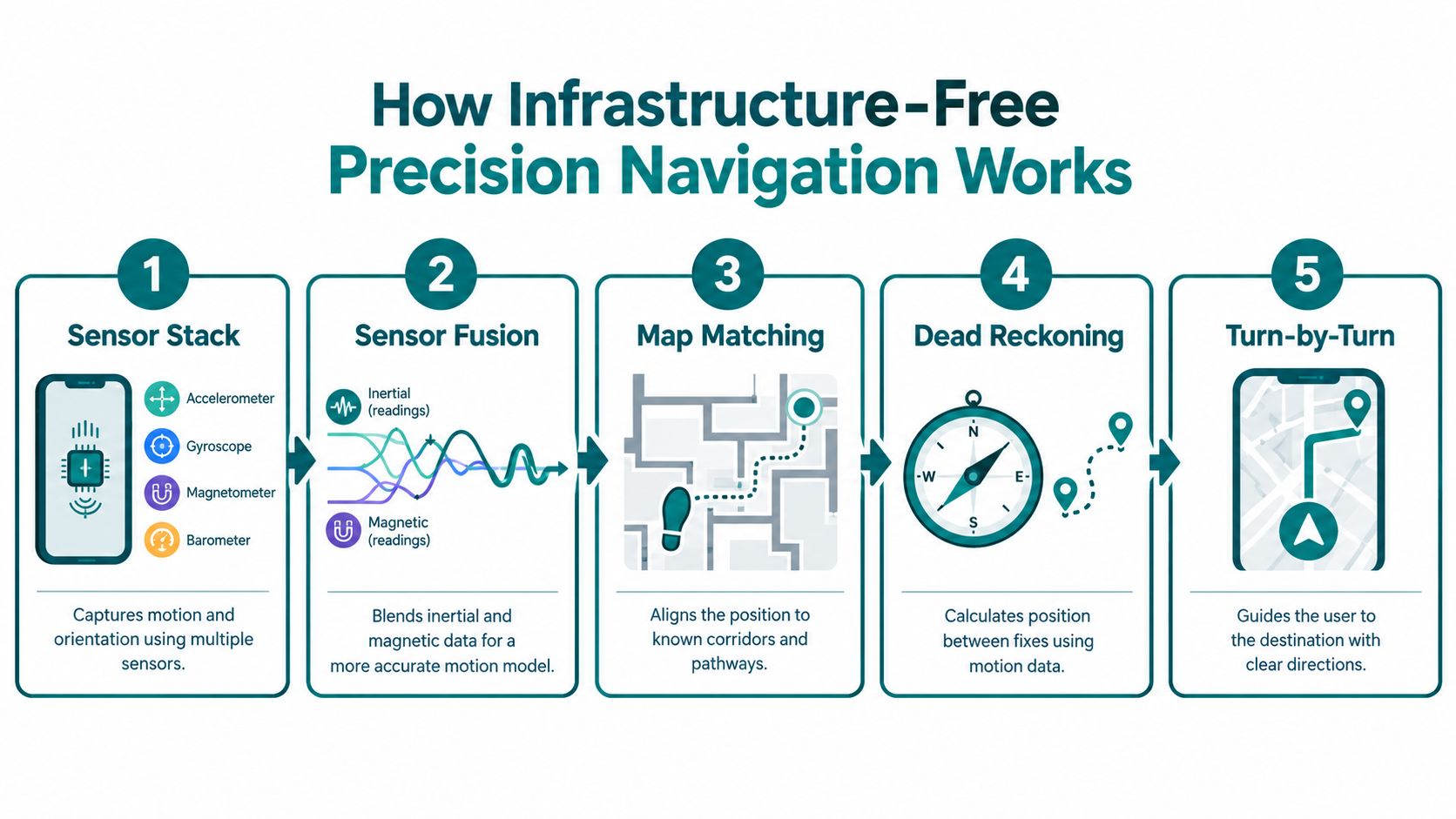
Infrastructure-free navigation uses the smartphone already in the visitor's hand. The device's accelerometer, gyroscope, magnetometer and barometer provide motion and orientation signals. Software combines those signals with a digital representation of the venue so the route can continue indoors, where GPS is unreliable.
The process is easier to understand as a sequence.
- The phone detects movement. The accelerometer recognises changes in motion, while step detection estimates how the person is progressing. The gyroscope and magnetometer help establish orientation, and the barometer can help identify changes in elevation.
- Sensor fusion combines imperfect inputs. No individual sensor gives a complete position. The software compares the readings and reduces the effect of temporary noise or drift.
- The route is matched to the building geometry. A phone reading that appears slightly outside a corridor can be corrected against the mapped walls, doors, stairs, lifts and circulation paths.
- Dead reckoning estimates the next position. The system calculates movement from a known or estimated starting point rather than waiting for an external signal.
- The app gives turn-by-turn instructions. The visitor receives directions to a specific destination, with the route able to reflect floor changes and access requirements where the venue data supports them.
GPS fails inside many shopping centres because concrete, steel, roofing and internal structures obstruct or weaken satellite signals. Wi-Fi availability doesn't solve that problem consistently, because access points, tenant networks and handoffs can change across a property. The Waymap explanation of GPS-free navigation describes the distinction between satellite-dependent positioning and sensor-led indoor guidance.
What the operator must provide
The operator still needs accurate venue information. That includes current floor plans, entrances, lifts, accessible toilets, Changing Places facilities, stairs, shop doors, temporary closures and relevant points of interest. A venue survey or mapping process turns that information into a navigable model, and the centre must maintain it when tenants move or routes change.
The vendor handles the positioning logic, route calculation and user experience, but it can't compensate for an inaccurate estate record. Many projects fail here. The technology may be capable of precise guidance, yet a closed lift, unrecorded temporary wall or relocated store still creates a poor journey if the operator hasn't updated the map.
The right procurement question is therefore not just, “How accurate is the app?” Ask instead:
- What is mapped: Does the scope include doors, internal circulation, car parks, lifts and accessible alternatives?
- Who updates it: Is there a named owner when a tenant changes its frontage or a route closes?
- How is it tested: Do blind and low-vision users, buggy users and visitors with limited mobility test the actual route?
- What reaches the visitor: Can the centre publish the route through its existing digital experience?
A software-only approach removes the need to install positioning hardware throughout every lettable area, but it doesn't remove the need for disciplined venue data.
Why Beacons, Wi-Fi Handoffs and App Kiosks Are Falling Short
Beacons can work in a controlled pilot. They become harder to defend when an estates team must maintain a fleet across a large, changing property. Installation requires access to ceilings or other mounting points, batteries need replacing, and tenant refits can alter signal behaviour or remove the intended line of coverage.
Wi-Fi fingerprinting has a different weakness. It depends on an environment that remains sufficiently stable for the positioning model to recognise. Shopping centres contain shared spaces, tenant networks, changing access-point layouts and handoff conditions that can make a route less predictable than the original technical design suggests.
Kiosks solve a narrow problem. They give a visitor information at a fixed location, but they don't help someone who has already walked past the kiosk, can't see the screen, needs a step-free route or wants guidance in a different language. Signage remains useful as a safety and orientation layer, but it doesn't provide live, turn-by-turn instructions to a specific door.
| Approach | Hardware required | Maintenance burden | Accuracy indoors | Accessibility fit |
|---|---|---|---|---|
| BLE beacons | Installed transmitters and mounting access | Battery replacement, coverage checks and refit management | Can be useful in designed coverage zones, but depends on installation and signal conditions | May support location logic, but doesn't by itself provide an accessible user experience |
| Wi-Fi positioning | Stable access-point environment and network data | Network changes, tenant variation and calibration | Dependent on coverage, signal behaviour and handoffs | Limited unless paired with accessible route design and suitable instructions |
| Interactive kiosks | Fixed screens and supporting power or connectivity | Screen, software and physical-site maintenance | Accurate only at the kiosk or within its information scope | Excludes visitors who can't use the screen or have already passed it |
| Static signage and directories | Printed signs, maps and illuminated totems | Reprinting, refitting and removal of outdated information | Provides orientation rather than continuous position | Helpful as a supplement, but weak for turn-by-turn, multilingual and step-free journeys |
| Infrastructure-free precision navigation | Visitor smartphone and a mapped venue | Map updates, route testing and content governance | Uses phone sensors matched to mapped building geometry | Can support audio, step-free and destination-specific guidance when configured for the venue |
The trade-off isn't “hardware versus software” in the abstract. It is whether the centre wants to inherit a physical maintenance liability every time the tenant mix changes. Hardware can be appropriate where a venue needs a dedicated sensing layer, but it should not be treated as the default answer for every mall.
Operators reviewing Bluetooth-based approaches should distinguish access-control infrastructure from visitor navigation. The Waymap discussion of Bluetooth access points is useful context for that decision.
A kiosk tells a visitor where they are standing. Precision navigation is designed to help them complete the journey.
Accessibility Standards That Put Wayfinding on the Operator Agenda
The Equality Act 2010, BS 8300-2:2018 and PAS 78:2014 should be read as a connected chain rather than three isolated documents. The Act establishes the legal context for reasonable adjustments and inclusive service provision. BS 8300-2:2018 addresses accessible built-environment design. PAS 78:2014 provides practical guidance for inclusive digital and wayfinding provision.
The important operational point is that accessibility isn't limited to the physical doorway. A centre can have an accessible entrance and still create a poor experience if visitors can't identify it, reach it from the car park or find an accessible toilet once inside. A route that depends on a visual map may also fail before the visitor has had the opportunity to use the facility.
Reasonable adjustment is a service question
For an operator, the defensible question isn't whether a particular device has been installed. It is whether the customer can access the service in a way that is reasonable, usable and properly communicated. That includes the information provided before arrival and the instructions offered during the visit.
The national review of the 25 largest UK shopping centres found that higher-scoring sites consistently combined mobility-hire provision, Changing Places toilets, accessible toilets and clear online accessibility information. Lower-scoring sites often missed one or more of those features, as reported in the national review of accessible shopping centres. The result is a useful service-design principle. Facilities matter, but accurate information about those facilities also affects whether people can plan and complete a visit.
Local accessibility guidance citing a 2025 UK disability survey reported that 78% of disabled people find shops and shopping centres inconvenient, while 66% reported the same for pubs, clubs and bars. Those figures appear in this accessibility guidance from Cheshire West and Chester Council. AccessAble also says it provides detailed access guides for more than 70,000 UK venues, showing that venue-level accessibility information has become part of how people plan trips.
Design, retrofit and ESG evidence
Approved Document M matters during new construction and fit-outs, but many shopping centres are managing inherited floorplates, later extensions and frequent tenant changes. A software navigation layer can sit alongside physical improvements and reduce the argument that accessibility must wait for a major capital project.
That doesn't make digital guidance a substitute for ramps, lifts, toilets, lighting or safe circulation. It makes wayfinding an additional operational control that can be updated as the estate changes. For ESG teams, the social value is easier to defend when the centre records what it has mapped, which routes it has tested, how it handles closures and how it responds to accessibility feedback.
The Waymap overview of UK accessibility standards provides further context for connecting accessible navigation with the built-environment obligations operators already manage.
For teams wanting a broader reference point on accessible information, find accessibility information can help frame the difference between a facility existing and a visitor being able to use it confidently.
Named Deployments That Show the Pattern in Practice
Named deployments are useful only when they clarify an operational pattern. A venue name by itself doesn't prove that a shopping centre will achieve the same result. The board needs to know what was mapped, what infrastructure was avoided, how the service fitted the visitor journey and which internal team owned the updates.
The public Waymap material identifies Westfield London, Westfield Stratford, WMATA, SBS Transit, LTA Singapore, CapMetro Austin and Lord's Cricket Ground as examples associated with precision navigation. They represent different environments, so they shouldn't be presented as interchangeable retail case studies. Their value is comparative: a multi-level shopping centre, an urban transit system, a bus network, a stadium and a mixed indoor-outdoor journey all expose different route and signal problems.
Westfield London is the relevant retail pattern. A centre of that type needs a digital map that can represent multiple levels, internal routes, entrances and exact destinations rather than a broad “near this anchor” instruction. Westfield Stratford provides a useful rollout question for estates directors: once a mapping template, governance process and integration approach exist, can the next site be brought into the same operating model without rebuilding the programme from scratch?
WMATA and SBS Transit show why indoor navigation needs to handle transitions rather than isolated rooms. A visitor may move between street level, a station, a concourse, a platform or a bus connection. Lord's Cricket Ground adds another challenge, with crowds, entrances, stands and event-day changes. The same underlying navigation approach can be assessed against each environment, but the route data and service rules still need local ownership.
| Venue | Scope | Infrastructure | Reported outcome |
|---|---|---|---|
| Westfield London | Multi-level retail navigation to mapped destinations | Software-led navigation with venue mapping | A live route layer can replace reliance on static orientation boards |
| Westfield Stratford | Retail-site rollout and repeatable mapping model | Designed for reuse across a related venue estate | A second site can inform rollout governance and mapping consistency |
| WMATA | Metro navigation through complex station environments | Navigation designed for signal-challenged spaces | Demonstrates the need to handle indoor and underground movement |
| SBS Transit | Bus network and interchange context | Smartphone-led route guidance | Shows how navigation can extend beyond one building |
| Lord's Cricket Ground | Stadium entrances and internal destinations | Venue mapping without a dependence on installed beacons | Illustrates the importance of event-day routes and changing visitor flows |
Operators should be cautious with claims about reduced help-desk enquiries, higher repeat visits or increased dwell time. Those outcomes may be commercially plausible, but they require the centre to instrument them rather than assume them. A proper pilot should compare route completion, assistance requests, accessibility feedback and tenant interaction before and after deployment.
For shopping centres such as Bluewater and Meadowhall, and for legacy intu sites, the practical lesson is not to copy another venue's marketing language. It is to define the route problem precisely, map the service, and measure whether visitors can reach the destinations they came to use.
ROI, ESG and the Operator's Deployment Checklist
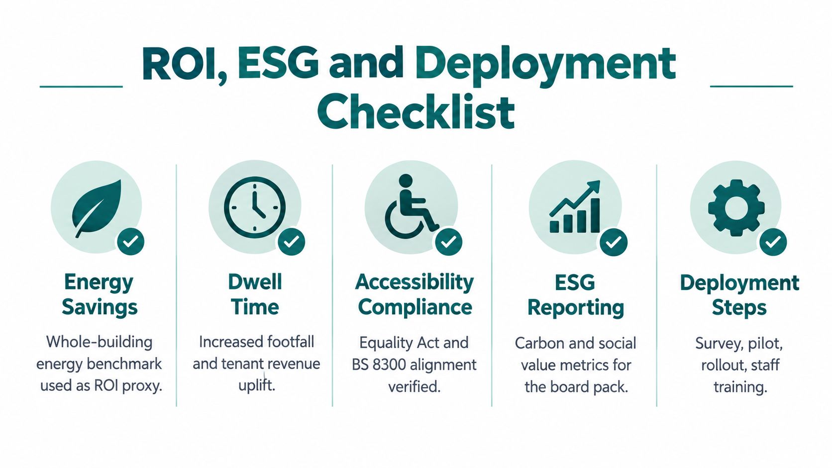
The return on a wayfinding project shouldn't rest on a made-up uplift in dwell time or basket value. Estates teams need a measurement model that separates confirmed savings from commercial hypotheses. Start with the costs the operator controls, then test visitor and tenant outcomes through a defined pilot.
Energy is one useful part of the operational baseline. The Better Buildings Partnership's 2024 REAL Estate Environmental Benchmarks framework distinguishes between the common mall, retail units and car parks in retail-centre energy datasets. That whole-building structure lets managers isolate base-building demand and examine controls, HVAC schedules, lighting and circulation-space conditioning.
A digital directory won't automatically create a material energy saving. The credible approach is to record which printed directories, illuminated totems or redundant information points are removed, retained or reduced, then connect those changes to the centre's energy and maintenance records. The same discipline applies to staffing. If a concierge team spends less time answering repetitive location questions, record the change in query categories and staff time rather than labelling it a saving before finance validates it.
A practical deployment sequence
Venue audit: Capture floor plans, entrances, car parks, lifts, stairs, accessible toilets, Changing Places facilities, tenant doors and temporary restrictions. Include the routes a visitor takes, not only the areas shown on a landlord plan.
Mapping and calibration: Convert the estate record into a navigable map, then test destinations from realistic starting points. Include level changes, one-way circulation, closures and alternative step-free routes.
Accessibility and language QA: Ask blind and low-vision users, buggy users and people with different mobility needs to test the journeys. Check terminology, audio instructions, destination labels and multilingual content against the centre's audience. Don't promise language coverage until the content has been reviewed and maintained.
App and loyalty integration: Decide whether the navigation service sits inside the existing centre app, a separate visitor experience or a partner interface. Link destination data to tenant pages only where the integration improves the journey.
Staff training: Concierge, security, facilities and tenant-relations teams need a simple escalation process. They should know how to report a blocked route, an outdated unit or a lift outage.
KPI instrumentation: Track route starts, destination searches, failed journeys, support requests, accessibility feedback and update response times. Treat dwell time, tenant conversion and repeat visits as hypotheses to test, not guaranteed outcomes.
Review cadence: Hold a formal review after the initial operating period and repeat it at a defined cadence. Recheck the map after major refits, seasonal layouts and changes to anchor stores.
The governance case belongs in the ESG pack. Accessibility outcomes support the social pillar, while clear ownership, update logs and tested controls support governance reporting. The Waymap perspective on operational cost savings is relevant when separating reduced physical infrastructure from the ongoing cost of maintaining an accurate digital service.
Board-pack test: Show the baseline, the intervention, the measured change and the owner responsible for keeping the result true.
Frequently Asked Questions for Shopping Centre Operators
What does shopping centre wayfinding cost per square foot?
There is no defensible universal cost per square foot. Pricing depends on the number of floors, destinations, entrances, route complexity, mapping condition, integrations and update requirements. Take an existing plan, a destination list and a sample of accessibility routes to procurement before asking suppliers for comparable proposals.
How long does indoor navigation take to deploy?
Lead time depends on venue readiness and mapping scope. A centre with reliable floor plans and a clear operational owner can move faster than one with undocumented changes and multiple tenant interfaces. Ask for a phased plan covering survey, map production, accessibility testing, integration, staff training and post-launch corrections.
Can it integrate with an existing tenant app?
Yes, integration should be assessed at the data and user-experience level. The centre needs a dependable destination catalogue, route entry points and a process for updating tenant information. Make the integration requirement explicit in the technical brief rather than adding it after supplier selection.
Does indoor positioning create GDPR obligations?
Potentially, depending on what data the service collects, how it links location to an identifiable person and how long it retains that information. Ask the supplier and the centre's data-protection lead to document the lawful basis, consent or notice position, retention, processor arrangements and user controls before launch.
How is Waymap different from beacon vendors?
Waymap uses smartphone motion-sensor data and mapped venue geometry rather than requiring an installed beacon fleet. The procurement comparison should cover accuracy, route quality, accessibility functions, mapping updates, integration, support and total operating cost, not only the presence or absence of hardware.
What accessibility evidence can the system produce?
A centre can document mapped accessible routes, destination coverage, route-test results, update records, user feedback and incidents such as lift closures. That evidence won't replace an accessibility audit, but it gives estates and ESG teams a clearer record of how wayfinding is managed.
What size of centre benefits most?
Large, multi-level centres with complex entrances, changing occupiers and significant accessibility requirements have the clearest navigation problem. Smaller venues can still benefit if visitors regularly struggle to identify units or accessible routes. Start with a route audit and measured pilot rather than choosing by floor area alone.
Waymap provides infrastructure-free precision navigation for venues that need accurate indoor, outdoor and underground guidance without relying on GPS, Wi-Fi or installed hardware. Visit Waymap to discuss a mapped, accessibility-focused wayfinding service for your shopping centre.
