
Your Shinjuku Station Map: A Guide to Exits & Transfers
Shinjuku hits you fast. The train doors open, the crowd moves before you've oriented yourself, and every sign seems to point somewhere useful but not necessarily where you need to go. If you're standing there searching for a Shinjuku Station map on your phone while people stream around you, you're in the same position as countless first-time visitors.
The good news is that Shinjuku isn't impossible. It's just unforgiving if you use the wrong method. The people who do best here don't try to memorise the whole station. They reduce the problem to three decisions: which operator they need, which gate or platform they're aiming for, and which exit matches the physical place they want above ground.
Meta description: A practical Shinjuku Station map guide covering exits, transfers, landmarks, and accessible navigation so you can move through Japan's busiest station with confidence.
Primary keyword: Shinjuku Station map
Semantic variants: Shinjuku Station exits, Shinjuku Station transfer guide, official Shinjuku Station map, Shinjuku exit map, Shinjuku Station navigation
How to Navigate Shinjuku Station Without Getting Lost
Many visitors get lost in Shinjuku for the same reason. They start by asking, “Where am I?” when the better first question is, “What is my next fixed target?” In a station this large, trying to understand everything at once usually makes you slower.
The practical approach is simpler. Pick one immediate objective. That might be a JR transfer, the East Exit, or the bus terminal. Once you reach that point, choose the next one. That's how station staff, guides, and frequent travellers typically move through the building.
A good rule is to ignore anything that doesn't help with your current decision. If you've just arrived on the Narita Express, you don't need to read every retail sign, every district name, or every alternate route. You need the signs for the next rail company or the correct gate. If your destination is above ground, you need the right exit group first, not a perfect mental model of the underground maze.
Practical rule: In Shinjuku, navigate in short segments. Platform to concourse. Concourse to gate. Gate to exit. Exit to landmark.
Printed maps, operator maps, and phone maps all help, but they fail in different ways. Operator maps are strong on internal layout. Phone maps are stronger once you're outside. Underground, signal and orientation can both become unreliable, which is why indoor navigation often breaks down in exactly the places where travellers need it most. Wayfinding systems that depend on satellite position also struggle indoors, as discussed in Waymap's piece on whether GPS works indoors.
If you treat Shinjuku as a series of short, deliberate moves instead of one giant puzzle, the station becomes manageable.
Understanding the Scale of Shinjuku Station
Before you can read a Shinjuku Station map properly, you need to understand what you're dealing with. Shinjuku isn't a single neat station hall. It's a connected transport city with multiple operators, linked spaces, underground passages, surface-level buildings, and exit systems that spill directly into very different parts of Tokyo.
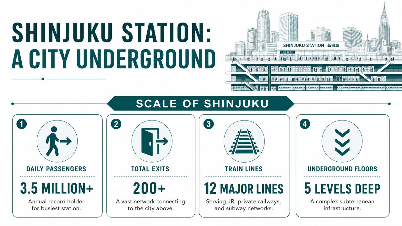
According to the Shinjuku Station entry on Wikipedia, Shinjuku Station is the world's busiest railway station, with an average daily usage of 3.59 million passengers in 2018, a figure officially registered with Guinness World Records. The same source notes that the complex has over 200 distinct exits, 35 main platforms, and 17 more in connected stations.
Why the station feels harder than other big hubs
Those numbers matter because they explain the lived experience. A station with a handful of exits lets you make small mistakes and recover quickly. A station with 200-plus exits punishes vague planning. “I'll just follow signs for outside” isn't a strategy here. It can leave you on the wrong side of the district, with a long walk around major roads or through crowded arcades.
The station complex also stretches horizontally as much as vertically. Passages don't just go up and down. They run long distances under shops, ticket gates, and connected buildings. That's why a route that looks close on a simplified map can still involve a substantial walk.
For transport operators and venue teams, this is exactly the kind of environment where fixed signage reaches its limit. Static signs can label routes, but they can't adapt to a traveller's destination, language, or confidence level. Waymap's work on 3D LiDAR scanning points to a broader reality in complex infrastructure. Accurate digital understanding of space matters when built environments become too intricate for glance-based navigation alone.
What the scale means for your route choice
If you're making decisions inside Shinjuku, three consequences follow:
- Exit choice matters early: Don't wait until you're near the surface to think about exits.
- Operator boundaries matter: A transfer inside one operator's area feels different from moving between rail companies.
- Landmark-first planning works better: Choose the district or venue first, then work backwards to the exit group.
The station isn't confusing because the maps are bad. It's confusing because the environment is larger and more layered than most travellers expect.
Once you accept that scale, the official maps start making more sense. They aren't trying to show one station room. They're trying to compress a transport district into something you can read in seconds.
How to Read an Official Shinjuku Station Map
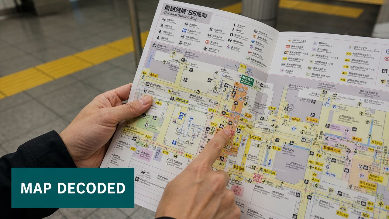
The official Shinjuku Station map looks crowded because it's doing several jobs at once. It identifies operators, platforms, ticket gates, facilities, circulation routes, and exits. If you try to read all of it at once, it blurs into noise. The trick is to read it in layers.
Start with the operator, not the exit
The first thing to identify is which rail company you're dealing with. In Shinjuku, that distinction matters. A JR route, a private railway route, and a subway route may all be “in Shinjuku”, but they don't behave as one unified system when you're moving through gates and corridors.
When you look at the map, find the operator logo or area label first. Then trace only the part of the map that belongs to that operator. This immediately cuts the complexity down.
Use this order:
- Find the rail company area you need.
- Locate the platform or gate tied to that operator.
- Only then check the exit if you're leaving the station.
That order prevents a common mistake. Travellers often focus on an exit name too early, then discover they're still in the wrong operator zone and have to backtrack.
Read symbols as categories
Most official station maps use icons consistently. Toilets, lockers, lifts, escalators, information counters, and accessible routes are usually shown with recognisable symbols. Don't treat them as background decoration. In Shinjuku, these symbols are route-planning tools.
A quick way to scan is to divide the map into three symbol groups:
| Map element | What it tells you | Why it matters |
|---|---|---|
| Lines and platform markers | Where trains depart and which network you're in | Prevents wrong-operator transfers |
| Gate and concourse labels | Where you'll emerge inside the station | Helps you orient before heading for an exit |
| Facility icons | Toilets, lifts, lockers, counters | Useful for pauses, accessibility, and regrouping |
The blue dot on a phone map often gives people false confidence indoors. It can suggest precision even when orientation is weak. That's one reason indoor navigation remains difficult in complex transport hubs, a point explored in Waymap's discussion of the blue dots.
Treat exit names as destination clues
Exit labels are not just door numbers. They are clues about the side of the station and the city area you'll reach. East, West, and South are the most important mental anchors. Once you know which side your hotel, attraction, or meeting point is on, the map becomes much easier to use.
Don't ask the map to tell you everything. Ask it one question at a time.
If you remember only one method, make it this one: operator first, then gate, then exit, then outside landmark.
Your Guide to Shinjuku Station Exits and Landmarks
The biggest weakness in most official maps isn't the station layout. It's the missing connection between station exits and the places people want to go. As noted in a traveller discussion in a public Facebook group, a common complaint is that official maps show the internal layout but fail to connect exits to surrounding landmarks. That's why so many people reach street level and still feel lost.
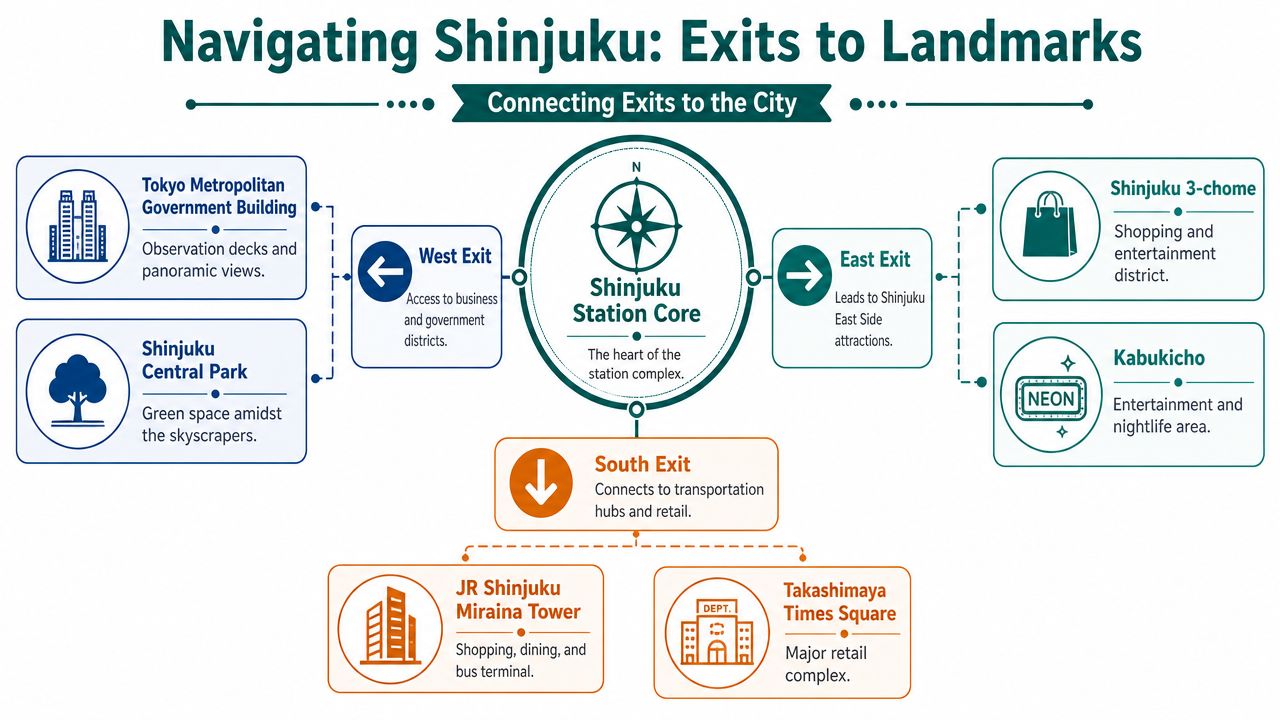
The practical fix is to stop thinking in terms of “Which exit number?” and start with “Which side of Shinjuku fits my destination?” Once you choose the right side, the final exit decision gets much easier.
If your destination is shopping or nightlife, aim East
The East Exit side is the one many leisure travellers need. This is the direction for the busier entertainment and retail areas, including Shinjuku 3-chome and Kabukicho. If you're meeting friends, heading towards department stores, or moving into the brighter late-night side of the district, East is usually your anchor.
Use East when your destination sounds like one of these:
- Shinjuku 3-chome: Shopping streets, department stores, and dining-heavy blocks.
- Kabukicho: Entertainment, nightlife, and late-evening meeting points.
- East-side hotels and retail addresses: Many visitors book accommodation here because it feels central and lively.
A common mistake is emerging too far south or west and then trying to walk around large blocks with luggage. In practice, that often takes longer than spending a few extra minutes getting the exit right underground.
This walkthrough helps visualise how exit choices affect your route:
If you need offices, hotels, or government buildings, go West
The West Exit side feels different immediately. The streets open up more, the towers rise higher, and the district becomes more business-focused. This is the side to target for the Tokyo Metropolitan Government Building, Shinjuku Central Park, and many of the large hotel towers in west Shinjuku.
Choose West for destinations such as:
- Tokyo Metropolitan Government Building: A common sightseeing stop because of its observation facilities.
- Shinjuku Central Park: Useful if you want open space after a long journey.
- West-side business hotels and office towers: Especially common for conference travellers.
The wrong side of Shinjuku doesn't just mean a wrong turn. It can mean a long, tiring correction through dense pavements and complex crossings.
If you need buses, newer retail, or a cleaner hand-off above ground, head South
The South Exit and New South Gate are often the easiest choice for travellers carrying bags or making onward connections. This side connects more naturally to Busta Shinjuku, JR Shinjuku Miraina Tower, Takashimaya Times Square, and routes towards Shinjuku Gyoen National Garden.
South is often the right target if you're doing one of these:
- Catching an express bus: Busta Shinjuku is the key reason many people need this side.
- Heading to Takashimaya Times Square: South is usually the cleaner approach.
- Walking towards Shinjuku Gyoen: South-side orientation usually makes more sense than exiting east and improvising.
When in doubt, ask your hotel or meeting point one very specific question before you travel: “Which Shinjuku exit side is closest, East, West, or South?” That answer is usually more useful than a full postal address.
Navigating Transfers Between Train Lines
Transfers in Shinjuku go wrong when people follow a destination name instead of the rail operator. A place name might appear on several signs. An operator logo and line identifier are usually more reliable.
Narita Express to a JR local line
If you arrive on the Narita Express and need another JR line such as the Yamanote Line, stay focused on JR signs first. Don't rush for an exit unless you're certain you're leaving the station altogether. Your first task is to reach the correct JR concourse or platform area.
A practical sequence looks like this:
- Step off and stop briefly at the platform edge, out of the main flow.
- Look up for JR line guidance, not street exits.
- Follow the line name and symbol consistently until you reach the right platform zone.
- Confirm the platform display before boarding, because trains in the same general area may head in different directions.
If you move calmly and resist the urge to improvise, this transfer is usually manageable. The trouble starts when travellers chase a general Tokyo destination and drift away from JR guidance too early.
JR to a different rail company
Changing from JR to another operator is where people often underestimate the friction. Depending on the route, you may need to move through a substantial corridor and, in some cases, pass through a different ticket gate arrangement.
Watch for these clues:
- Operator branding changes: Colours, logos, and map styles often shift.
- Gate transitions: A signposted transfer may still involve a formal operator boundary.
- Crowd pattern changes: Commuter flows often hint at major transfer channels, but don't rely on the crowd alone.
A lot of stress comes from trying to move too fast. Shinjuku rewards confirmation. At each decision point, check one sign above eye level and one fixed map or platform display nearby. If both agree, keep moving.
For travellers who want spoken turn-by-turn help in major transport environments, Waymap's overview of public transportation directions reflects the wider need for route guidance that works beyond outdoor GPS.
If two signs seem to conflict, trust the one that names your operator and line, not the one that sounds closest to your final destination.
Three transfer mistakes to avoid
- Leaving the paid area too early: This can add unnecessary walking and another layer of decision-making.
- Following only English place names: They help, but operator and line identifiers are usually more dependable.
- Assuming nearby means quick: In Shinjuku, a short distance on the map can still mean a long indoor walk.
The calmest transfer strategy is boring on purpose. Follow the company, then the line, then the platform.
The Ultimate Solution for Accessible Navigation
A standard Shinjuku Station map assumes that you can see well, interpret dense visual information quickly, and use colour-coded signs under pressure. That's a weak assumption in a station this complex. As discussed in a traveller thread on Reddit, traditional wayfinding in complex stations like Shinjuku assumes all users can see and interpret colour-coded signs, which excludes visually impaired users and confuses non-Japanese speakers.
That challenge isn't only about blindness or low vision, though that need is fundamental. It also affects travellers with limited Japanese, people who find high-stimulus environments disorienting, and anyone whose confidence drops once phone maps lose context underground.
Why visual wayfinding breaks down
In theory, Shinjuku's signage system is rich with information. In practice, three things go wrong:
- Too much information arrives at once: Signs compete with retail, crowd movement, and platform urgency.
- Colour and text carry too much of the load: If either is hard to process, the system weakens fast.
- Underground navigation loses context: A user may know the destination but not their precise position relative to it.
For blind and low-vision travellers, this is more than inconvenience. It's a direct access problem. That's where non-visual navigation becomes essential, not optional.
What infrastructure-free navigation changes
Waymap was built specifically for this kind of environment. Instead of depending on GPS, Wi-Fi, or installed beacons, the platform uses dead reckoning with device-native smartphone sensors to provide step-accurate audio guidance in infrastructure-free environments. Waymap also provides sub-3-metre accuracy and doesn't require pre-mapping changes every time a venue has staffing turnover or frequent layout updates. Those details matter in stations because hardware maintenance across high-footfall spaces is operationally difficult.
This aligns with the practical intent behind accessibility frameworks and duties such as the Equality Act 2010, ADA Title III, BS 8300, PAS 78, and BS EN 17210. The common thread is equivalent access to the built environment. In a place where visual signage is the default, audio-first guidance provides a more equivalent route through the same space.
Waymap's real deployments show why infrastructure-free matters. In transport and major public venues, maintaining physical wayfinding hardware across large estates creates cost, inspection burden, and operational drag. A digital layer avoids many of those problems.
For anyone who wants to try that approach directly, the app is available from the Waymap download page.
A station doesn't become accessible because it has more signs. It becomes more accessible when people can navigate it in the way that works for them.
Frequently Asked Questions About Shinjuku Station
Is there an official Shinjuku Station map I can use before I arrive
Yes. Official operator maps are the best starting point before arrival. Use them to identify your operator, likely gate, and the exit side closest to your destination, then save a screenshot so you're not relying on signal underground.
What's the best Shinjuku Station map for exits
The best Shinjuku Station map for exits is one you annotate with your actual landmark above ground. Official maps are strong on internal layout, but they're less helpful when you need to connect an exit to a hotel, park, government building, or bus terminal.
Which side of Shinjuku Station should I use for Kabukicho
Use the East Exit side for Kabukicho. If you come out on the west or south side by mistake, you may add an unnecessary street-level detour.
Which exit should I use for the Tokyo Metropolitan Government Building
Use the West Exit side. That's the correct orientation for the government building area and the office-heavy west side of Shinjuku.
Which exit is best for Busta Shinjuku
Use the South Exit or New South Gate area. That's usually the cleanest approach for express bus connections and nearby south-side retail complexes.
Is Shinjuku Station difficult for first-time visitors
Yes. Shinjuku is difficult for first-time visitors because scale, crowd flow, and multiple operators create too many choices at once. It becomes much easier when you break the journey into short targets and decide your exit side before you travel.
Can I rely on Google Maps inside the station
Sometimes, but not completely. Indoor mapping can help, but it still often requires manual zooming and interpretation, especially when you need to understand how exits relate to real-world landmarks above ground.
How early should I arrive for a transfer at Shinjuku
Arrive with margin if your route involves a different operator or an unfamiliar exit. Even confident travellers lose time here when they assume a transfer will be obvious on arrival.
What should I do if I feel lost inside Shinjuku Station
Stop moving, step out of the main pedestrian flow, and reduce the problem to one next target. Find your operator, then your line or gate, then your exit. Don't try to solve the whole station in one glance.
Is there an accessible alternative to reading the Shinjuku Station map visually
Yes. Audio-based navigation is the most practical alternative when visual maps and colour-coded signs aren't enough. It's particularly useful in underground or signal-poor areas where standard phone navigation can become unreliable.
If you need guidance that works indoors, outdoors, and underground without relying on GPS or installed hardware, Waymap offers a practical alternative to static maps and visual-only signage. Built first for blind and low-vision users, it provides step-accurate audio guidance to exact doors, platforms, and points of interest, making complex spaces like major stations easier for everyone to get around.
