
Royal Alexandra Hospital Map: Easy Navigation Guide
Corsebar Road, Paisley, PA2 9PN is the address, and the switchboard is 0141 314 7294. If you're coming for an appointment, the first three things to sort are where to park, which entrance your clinic uses, and how you'll get to the right ward without doubling back.
A royal alexandra hospital map only helps if you read it as an arrival tool, not as the full answer. On a site that serves a wide catchment and has a campus layout built around multiple units, the gap between “found the hospital” and “found the right door” is where people lose time, confidence, and, too often, the appointment itself.
What You Actually Need Before You Travel
A first-time visitor pulling into the hospital after a long drive doesn't need a prettier PDF. They need to know whether they should head for the main entrance, the maternity unit, or another unit, and whether the walk from the car park is straightforward or likely to involve backtracking.
That's the point where the official campus map becomes useful, but only as one layer in the journey. For people travelling from a broad regional catchment, the practical question isn't “Where is Royal Alexandra Hospital?” It's “What door do I use when I get there, and how do I avoid arriving flustered?”
The most common failure is not finding the hospital, it's arriving at the wrong edge of the campus and having to start again.
The visitors who benefit most from a proper Royal Alexandra Hospital map are usually the same ones who have the least time to spare. That includes first-time outpatients, relatives heading to maternity, people using accessible parking, and anyone arriving by bus or train with bags, a mobility aid, or a child in tow.
The map also has to match the purpose of the visit. A relative going to a ward block needs a different mental model from someone attending a clinic appointment, and a pregnant partner heading to maternity should not be left interpreting the campus like a staff member already knows the route. That's why the useful version of hospital wayfinding starts before the car door opens.
Reading the Official Royal Alexandra Hospital Campus Map
The NHS Greater Glasgow and Clyde campus map is a campus map, not a turn-by-turn indoor guide. It places the hospital at Corsebar Road, Paisley, PA2 9PN and shows the main hospital as a spread of named areas, including the main entrance, maternity unit, wards, and other major departments, which is exactly what a first visit needs at the planning stage. The hospital is also described as being about 1.5 miles from Paisley Town Centre in the campus materials, which helps visitors understand its position without assuming a single front door model.
Royal Alexandra Hospital campus map PDF
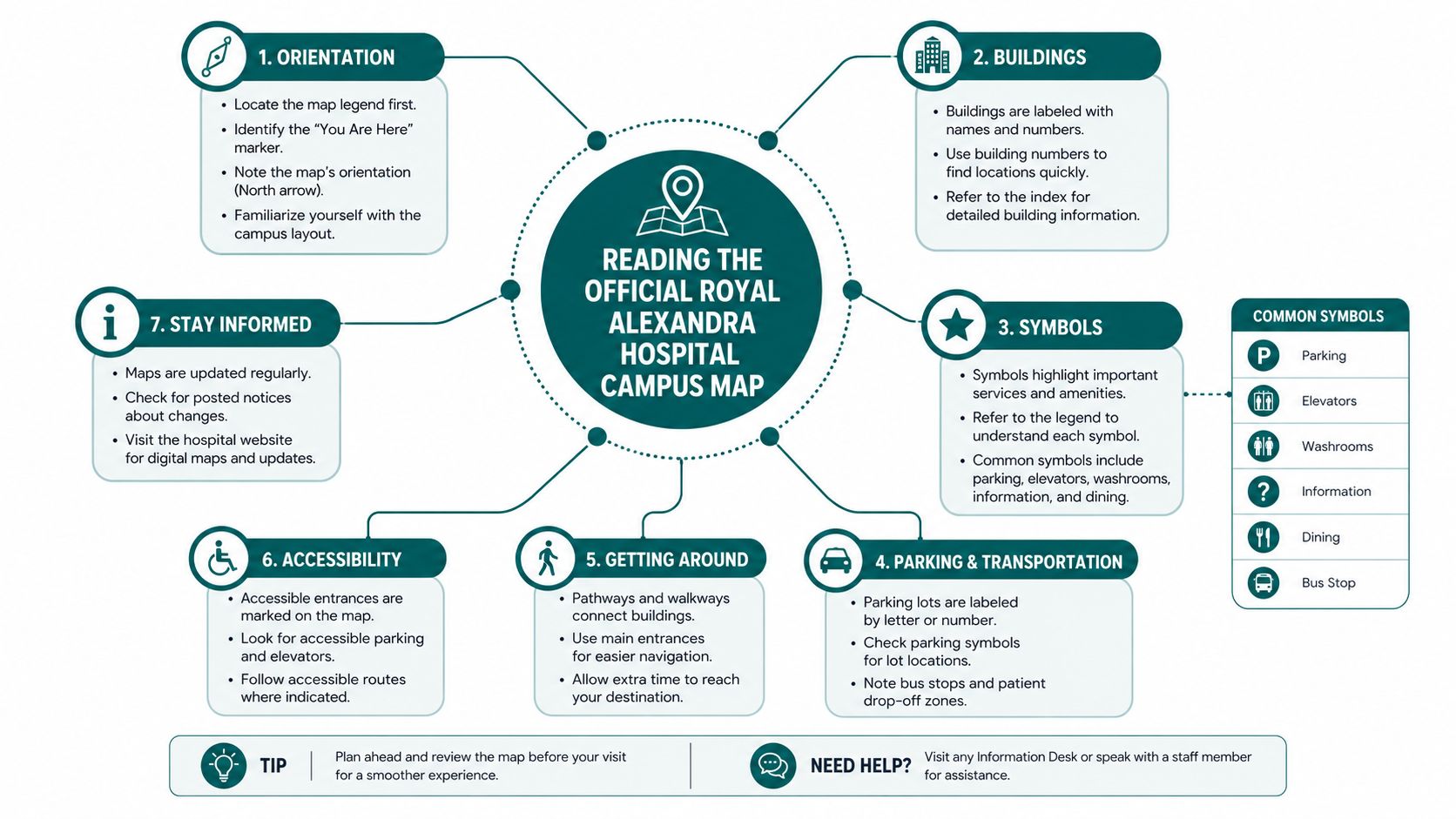
How to read it properly
Start with the postal anchor, then identify which part of the campus your appointment belongs to. If you're being seen in maternity, for example, the entrance decision matters more than the overall hospital outline.
Practical rule: use the PDF to decide the campus zone, then use arrival guidance to decide the door.
The map is valuable because it shows how the site is distributed across several units rather than pretending everything sits under one roof. It is less useful once you're standing on the campus edge and need to know which entrance, corridor, or lift serves your actual destination.
The main limitation is simple. A static PDF doesn't tell you which route is step-free, which door is closest to your appointment, or what to do if you arrive from the wrong side of the campus. That's why interactive campus mapping has become a separate category of wayfinding rather than a replacement for the hospital leaflet, as outlined in interactive campus maps.
Departments, Wards and Points of Interest Across the Campus
The useful way to think about the campus is by destination, not by building label. A visitor usually wants the main entrance, maternity unit, a named ward, or a clinical department, and each of those has its own arrival logic once you're on site.
What matters before you leave home
If you don't know which department owns the appointment, call the switchboard on 0141 314 7294 and ask two direct questions. First, “Which entrance should I use?” Second, “Is the destination on a ward block, a clinic level, or a separate unit?”
Those questions matter because people often assume the main entrance is always the right place to start. It isn't, especially when maternity or a specific ward is involved.
The campus map helps because it plots the major destinations as separate zones, which is useful for orientation but not enough for final routing. A relative can be on the right hospital campus and still end up on the wrong corridor if they don't confirm the destination in advance.
The common visitor mistakes
- Maternity visitors: they often arrive at the wrong entrance first, then have to re-route across the campus.
- Ward visitors: they can be sent toward the wrong block if they rely on a general hospital name rather than the exact ward.
- Outpatients: they sometimes forget that the check-in point and the nearest parking area are not always the same thing.
If a clinic or ward name is unclear on the appointment letter, call before you travel. That single call saves more time than any printed map ever will.
The practical habit is simple. Use the map to understand the campus shape, then use the switchboard to confirm the exact door and check-in point. That combination reduces the risk of walking in circles, which is the part nobody plans for but many visitors experience.
Driving In, Parking and Choosing the Right Car Park
Parking is where most hospital journeys become messy, because the map and the parking rules often live in separate places. On the Royal Alexandra Hospital campus, that split matters, since visitors need to know not just where the building is but which approach, bay, or permit fits the appointment.
The public evidence around parking logistics makes the broader pattern clear. In other Royal Alexandra Hospital campus materials, parking guidance is handled separately from the site map, and the information visitors need is spread across documents rather than being combined into one arrival path. For hospital users, that means the right question is not “Is there parking?” but “Which parking option matches my visit and entrance?”
| Royal Alexandra Hospital car parks at a glance | Best For | Closest Entrance | Payment |
|---|---|---|---|
| Short-stay parking | Outpatient appointments and quick drop-offs | Main entrance | Check the on-site parking guidance before setting off |
| Long-stay parking | Longer visits and relatives staying on site | Main entrance or the unit you're visiting | Check the on-site parking guidance before setting off |
| Accessible bays | Blue Badge holders and anyone needing a shorter walk | Main entrance or maternity unit, depending on destination | Check the on-site parking guidance before setting off |
The value of a table like this is not precision for its own sake. It forces the driver to decide early, before they're already turning into the campus and trying to read signs through a windscreen.
For visitors who are used to bigger hospital sites, the main mistake is assuming that any available space is close enough. It usually isn't. A better approach is to choose the parking type first, then confirm the entrance second, then walk the shortest obvious route from there.
Step-Free Routes, Lifts and Accessible Facilities
Accessibility planning starts before the front door, because a campus map rarely shows the full lived route. A visitor using a wheelchair, walking frame, crutches, or a pushchair needs to know where the step-free path begins, where the lift is, and whether the route to the entrance is manageable without help.
The Equality Act 2010 creates the duty, but the operational question is simpler. Can someone reach the right desk without being forced into stairs, detours, or unnecessary waiting? If the answer is no, the map has stopped short of the user need.
A useful route plan normally includes three checkpoints. First, the step-free link from the car park or drop-off point. Second, the lift or ramp that connects floor levels inside the main block. Third, the nearest accessible toilet and the quickest way to reach it without asking several people for directions.
A good accessible route removes decision-making at the door. It doesn't ask a visitor to improvise after they've already arrived.
For estates teams, this is also where infrastructure becomes a real question. If you're comparing physical upgrades against software-led routing, it helps to read a practical breakdown of wheelchair lift costs and ADA compliance before deciding how much hardware you're willing to maintain over time.
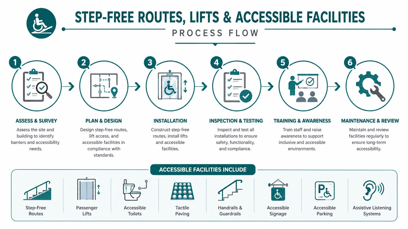
The key point is that accessible wayfinding is not just about compliance language. It's about removing friction for people who can't afford a wrong turn, a staircase, or a receptionist having to interrupt their work to explain a route that should already be obvious.
Why a Static Map Stops Working at the Hospital Door
A PDF can tell you the campus shape. It cannot tell you what the building feels like once you're inside it, moving under time pressure, trying to find the right clinic before your slot disappears.
The static map is strongest at the planning stage. It gives a postal address, a unit list, and a broad layout. Dynamic indoor navigation is stronger at the point of movement, because it gives turn-by-turn directions from the exact place you're standing to the exact room you need.
Static map versus live route
A static map asks the visitor to interpret. A live route tells them what to do next.
That difference matters for NHS estates teams because the operational trade-off is real. A signage-only approach may be cheaper at purchase, but it still leaves visitors dependent on memory, staff interruptions, and local familiarity. A beacon-heavy approach brings hardware maintenance and replacement into the picture. A software-led approach reduces the hardware burden, but it only works if the route data stays current.
The stronger solution is the one that can change as the hospital changes. That could mean a temporary clinic move, a corridor closure, or a rerouted appointment path after estates work. A printed PDF can't adapt once it's been posted.
For readers who want the technical contrast in plain language, the difference between satellite assumptions and indoor reality is covered in does GPS work indoors. That's the core gap the hospital door exposes.
Door-Level Navigation With Waymap Inside the Hospital
Waymap's indoor navigation uses dead reckoning from the smartphone's own motion sensors, which means it can guide people indoors without GPS, Wi‑Fi, Bluetooth beacons, or installed hardware. For a hospital campus, that matters because the route starts where the paper map stops, at the actual door, corridor, and lift threshold.
The system adapts to each person's walking pattern, so the guidance is based on the way the user moves rather than on fixed assumptions about pace. For a blind or low-vision visitor, that means heads-up audio directions through earphones or the phone speaker. For everyone else, it still means less guessing and fewer wrong turns.
What that changes on a hospital campus
A clinic can be added, a destination can be updated, and a closed route can be replaced without reprinting the campus PDF. That's the operational difference estates teams care about when layout changes are frequent or staff turnover makes static signage stale quickly.
The practical benefit is that wayfinding becomes a live layer, not a one-time print job. In a venue like Lord's Cricket Ground, the same idea has been used to guide people through a large, changing public environment, which is exactly the kind of navigation challenge hospitals face during busy appointment windows.
If you want a hospital-focused deployment model, the most direct next step is to download the Waymap app and test how indoor routing behaves from an actual entrance to an actual destination.
Useful test: if a system can get a visitor from parking to the correct clinic without asking for staff help, it's doing the part that static signage never will.
The value here isn't novelty. It's operational calm, especially for visitors who arrive anxious, time-poor, or unfamiliar with the building.
Meeting Accessibility, Procurement and ESG Standards
Navigation projects often start as an accessibility fix and end up in procurement review. That's where the actual decision gets made, because estates teams have to justify not only the user benefit but also the maintenance burden, the capital spend, and the long-term fit with ESG goals.
The compliance anchors are straightforward. The Equality Act 2010 creates the duty to make reasonable adjustments. PAS 78 and BS 8300 give the design and accessibility context. Together, they point toward routes that are usable, not merely present on paper.
A software-only navigation layer has a practical advantage in that discussion. It avoids the hardware line item that comes with beacon-based systems, which makes it easier to defend in capital review and simpler to maintain over time. That matters in public-sector settings where every physical install creates another item to inspect, replace, and support.
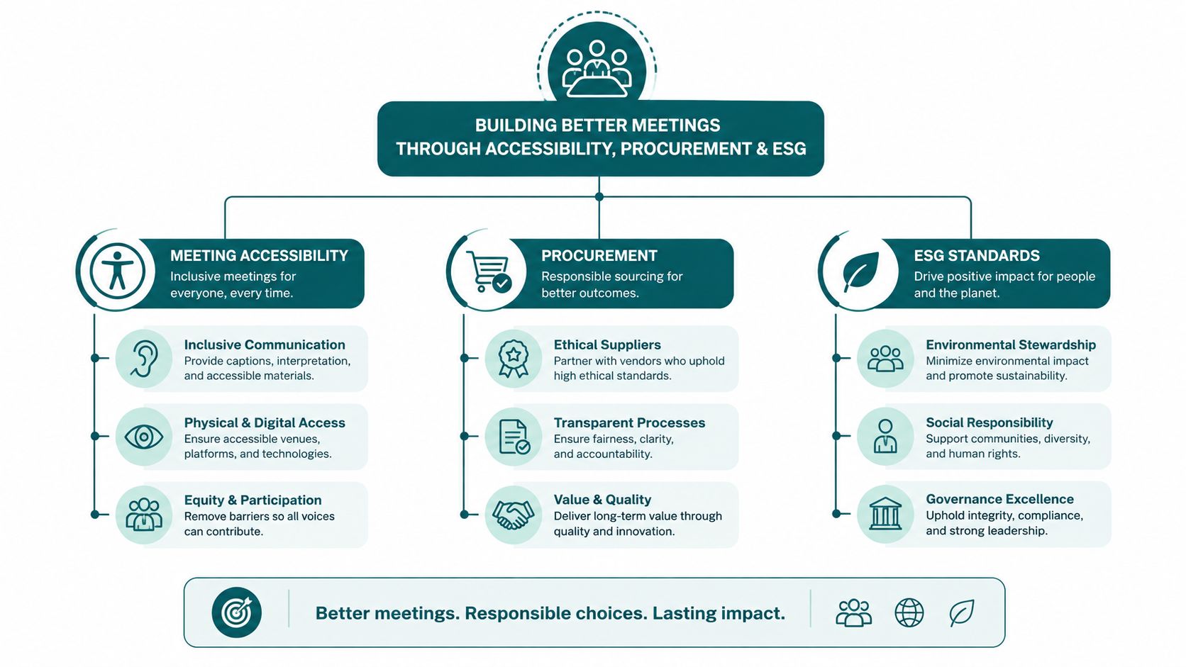
For procurement teams, the useful reference point is public sector procurement, because the decision is rarely about technology alone. It's about whether the chosen solution can satisfy accessibility, reduce maintenance, and fit the way public organisations approve spend.
That's why infrastructure-free navigation is more than a convenience. It's a cleaner fit for estates teams trying to meet accessibility obligations without creating another maintenance estate.
Arriving by Bus, Train, Bike and On Foot
Not every visitor arrives by car, and plenty shouldn't have to. The Royal Alexandra Hospital serves a wide catchment, so public transport and active travel need to be treated as real arrival options rather than afterthoughts.
The public-facing journey should still be simple. You need one route from the stop, one route from the station, and one route from the town centre that gets you to the entrance without forcing you to ask three people which side of the campus you're on.
Non-car arrival options to keep in mind
- Bus users: confirm the stop that puts you nearest the entrance you need, not just the hospital boundary.
- Train users: plan the final leg before you leave the station, especially if you're heading to maternity or a ward block.
- Cyclists and pedestrians: follow the route that lands you at the correct entrance, then use the campus map to orient yourself on arrival.
- Drop-off users: agree the pick-up point in advance, so relatives aren't circling the site after appointments.
The point of mixing transport modes into the same reference is that visitors often switch plans halfway through the day. A relative may arrive by bus but leave by car, or one family member may walk from Paisley town centre while another meets them at the entrance.
For teams building a better public transport journey, public transportation directions is the relevant idea, because confidence in the last few metres is what makes the whole trip feel manageable. The same logic applies whether the visitor is coming from Glasgow, Johnstone, or the wider Argyll corridor.
A Practical Pre-Visit Checklist and When to Call Ahead
Start with the address, Corsebar Road, Paisley, PA2 9PN, then confirm the appointment entrance, parking choice, and any step-free needs. If your visit involves maternity, a named ward, or a mobility aid, call 0141 314 7294 before you leave so you don't discover a change after you've already parked.
Use the campus map for orientation, but don't rely on it for the last decision. If the appointment has changed, the ward has moved, or you need a porter, the switchboard is the right place to ask before you travel.
For first-time visitors, it also helps to prepare the non-clinical basics the night before. A simple bag check for labour or an overnight stay can reduce the number of things you're juggling at the door, and a practical stress-free hospital bag list can help with that part.
The shortest version is this. A Royal Alexandra Hospital map gets you to the campus, but the right route gets you to the right room. That's the layer Waymap is built to handle, from kerb to door to destination.
Waymap gives hospitals a live navigation layer that goes beyond a static campus PDF, with indoor, outdoor, and underground guidance to exact doors and points of interest. If you're responsible for patient access, estates, or accessibility, visit Waymap to see how door-level navigation can fit a site like Royal Alexandra Hospital.
