
Motion Sensor App Guide for Indoor Navigation
You've followed the signs to the station entrance, but the platform is behind a concrete wall, the lift is on another level, and the departure board doesn't tell you which corridor to take. A wheelchair user can face the same problem in a shopping centre when the accessible route branches away from the main walkway. The issue isn't a lack of information. It's a failure to turn information into reliable, usable movement.
A motion sensor app addresses that gap by using the smartphone already in a visitor's hand. Accelerometers, gyroscopes, magnetometers and other device-native sensors can support turn-by-turn guidance inside buildings, underground concourses and tunnels, where GPS can't provide a dependable position. The approach also avoids requiring every venue to install beacons, survey radio signals or maintain a dedicated positioning network.
Why a Motion Sensor App Changes Indoor Navigation
Indoor navigation is difficult because buildings remove the references that outdoor mapping systems usually depend on. Concrete, steel, underground construction and enclosed corridors can block or distort satellite signals. A map may show that a platform, lift or accessible toilet exists, but it won't necessarily tell a visitor when to turn, whether the route is step-free, or which entrance leads to the right destination.
A motion sensor app works from a known starting point and follows the user's movement. It estimates steps, direction and changes in elevation from sensors inside the phone, then relates that movement to a detailed venue map. This makes sensor-based indoor navigation possible without relying on GPS, Wi-Fi, Bluetooth or installed beacons. The Mobility Innovation Marketplace describes Waymap as providing step-by-step guidance indoors, outdoors and deep underground using only sensors built into standard smartphones, with full door-to-door journeys supported by the system. The Waymap product entry also describes operation without physical infrastructure such as Bluetooth beacons or Wi-Fi routers.
Practical rule: A useful route must describe movement, not merely display a destination.
That distinction matters to people who are blind or partially sighted, wheelchair users, visitors unfamiliar with a venue and anyone moving through a complex interchange under time pressure. RNIB identifies navigation technology as an established category of assistive technology for blind and partially sighted people in the UK, including tools that help users find their way around their surroundings and choose where to go. RNIB's navigation guidance provides the relevant accessibility context.
For venue managers, the operational change is just as important. Traditional indoor positioning can depend on hardware distributed throughout a building, radio surveys, calibration and ongoing maintenance. An infrastructure-free model moves much of the navigation capability into the visitor's device and the app's algorithms. Venue teams still need accurate maps, accessible route information and a process for updating changes, but they aren't forced to treat navigation as a building-wide hardware installation.
The UK has a substantial base of compatible devices. A peer-reviewed study using UK data reported 92% smartphone penetration in the United Kingdom in 2021, with penetration increasing each year over the preceding decade, and drew on 100,000 UK Biobank participants. The UK smartphone sensing study shows why a phone-based approach can be deployed across a broad population rather than being limited to users carrying specialist equipment.
How Motion Sensors and Sensor Fusion Actually Work
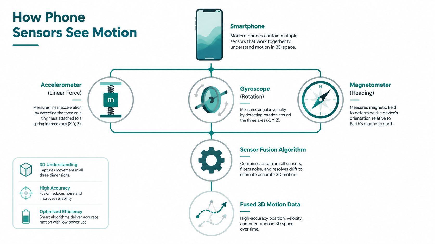
A modern smartphone contains several microelectromechanical systems, commonly called MEMS sensors. Each measures a different physical property, and each has weaknesses that make it unsuitable as a complete navigation system on its own.
The three core measurements
- The accelerometer measures changes in linear motion across three axes. A navigation engine can use those changes to recognise walking patterns, estimate steps and detect movement intensity.
- The gyroscope measures angular velocity. It helps determine how the phone is rotating, which supports heading estimation when the user turns.
- The magnetometer measures the Earth's magnetic field and can provide a compass reference. Buildings contain metal, electrical equipment and other sources of interference, so the reading must be assessed rather than accepted blindly.
The phone may also provide barometric pressure readings. Changes in pressure can help an algorithm identify movement between floors, although the app must distinguish a genuine elevation change from environmental pressure variation.
Dead reckoning needs correction
Dead reckoning starts with a known position and repeatedly adds estimated movement to it. If the system knows where the user began, it can estimate the next position from the length and direction of each step. The calculation resembles a running trail of vectors, each new movement extending the previous coordinate.
The problem is that every estimate contains uncertainty. A slightly incorrect step length, a small heading error or a phone held at an unusual angle can move the calculated position away from the user's actual position. Sensor fusion algorithms reduce that risk by comparing multiple readings and changing the confidence assigned to each one. The practical mechanism behind this approach is explained in Waymap's sensor-fusion algorithm overview.
A fusion engine can recognise when the user is stationary, reject a magnetic reading that conflicts with the wider movement pattern, and compare the estimated path with mapped corridors or junctions. The result isn't a satellite-style absolute position. It's a continually updated estimate of where the user is relative to the starting point and the mapped route.
That's why a motion sensor app can guide someone through a basement concourse or windowless corridor. The phone doesn't need to see the sky. It needs reliable movement measurements, a suitable map and algorithms that know when a sensor reading should be trusted.
Accuracy, Drift and the Real Limits of Dead Reckoning
A motion sensor app isn't accurate just because a phone contains sensors. Raw inertial navigation has a fundamental weakness called drift. The system integrates acceleration to estimate velocity and then integrates velocity to estimate position. A small bias in the first measurement can therefore become a much larger position error over time.
The limitation is measurable. A 2023 analysis of smartphone MEMS accelerometers and gyroscopes found that, across five smartphones, horizontal error exceeded 1 kilometre in 100 seconds during pure inertial navigation. The Sensors analysis concluded that sensor fusion is necessary because MEMS drift makes long-term dead reckoning unreliable without external correction.
That finding shouldn't be read as a rejection of inertial navigation. It defines the engineering problem. A production system needs to detect when the phone or foot is stationary, constrain movement to plausible corridors, reject distorted magnetic readings and identify floor changes. A known starting point and occasional map-based anchors also matter.
What performance evidence can show
Independent research demonstrates that motion-sensor-only tracking can reach practical indoor accuracy when algorithms are properly calibrated. A University of Edinburgh study reported that recurrent neural networks estimated location from motion sensors alone with a median error within 5 metres. The Edinburgh inertial-sensing publication supports the view that smartphone-only positioning can be computationally suitable for mobile navigation.
The evidence also supports caution. Accuracy depends on the device, how the user carries it, the route geometry, magnetic conditions and the quality of the venue map. A vendor claiming sub-metre or sub-three-metre performance should explain the test conditions, route lengths, user groups and failure-handling process.
| Technology | Typical accuracy | Infrastructure required | Maintenance burden |
|---|---|---|---|
| GPS | Poor or unavailable indoors | Satellites and reception | No venue hardware, but indoor performance is unsuitable |
| Wi-Fi fingerprinting | Depends on access-point density and survey quality | Wi-Fi network and radio survey | Network changes require reassessment |
| Bluetooth beacons | Depends on beacon placement and calibration | Installed beacons and gateways | Hardware, batteries and replacements |
| Motion sensor app | Practical accuracy depends on sensor fusion, maps and route conditions | Smartphone sensors and mapped routes | Software and map updates rather than distributed positioning hardware |
The Waymap explanation of inertial measurement units is useful for separating the sensor capability from the navigation layer built around it. Dead reckoning is a trajectory engine, not a magic replacement for every positioning method. Its strength is that it can continue through signal-poor spaces when the system starts from a reliable point and manages drift intelligently.
Why Removing Beacons Is the Operational Breakthrough
Installed infrastructure creates work for the people who have to own it. A venue manager must approve hardware locations, coordinate access, maintain an asset register and account for changes to walls, shops, corridors and entrances. A transport operator must consider high-footfall areas, underground environments and the possibility that equipment will be damaged, moved or obstructed.
NHS estates teams face an additional constraint. A navigation project competes with clinical, building and compliance priorities, and hardware that needs installation across a hospital estate can be difficult to fund and maintain. Wi-Fi fingerprinting adds another dependency, because the venue must survey signal patterns and revisit them when access points or building layouts change. Bluetooth beacons introduce batteries, gateways and physical units distributed throughout the route.

The ownership model changes
An infrastructure-free motion sensor app still requires careful venue preparation. Operators need to supply accurate floor plans, identify accessible routes, define entrances and exits, and maintain points of interest. What changes is where the positioning hardware sits. The device travels with the user, while route logic and venue information can be updated through software.
That distinction becomes valuable across estates with changing tenants or layouts. A shopping centre can alter a retail unit, a hospital can change a clinic location and a transport operator can revise a concourse route without relocating a network of beacons. The operator's main task becomes maintaining the digital map and testing the resulting instructions.
For estates teams, the important question isn't only whether a system can locate a visitor. It's who must repair it when the building changes.
A beacon failure can affect a defined physical area until someone finds and replaces the unit. A software-based approach has different failure modes, including poor mapping, sensor variation and app compatibility, but it avoids a distributed hardware estate. Waymap's discussion of Bluetooth access points provides context for the contrast between installed access-point systems and phone-native sensing.
The practical case is therefore about operational control, not just capital avoidance. Navigation accuracy travels with the user's phone instead of depending entirely on venue-owned equipment. That can make deployment easier to replicate across stations, campuses, shopping centres and public buildings, provided the operator treats accessibility testing and map governance as core work rather than optional extras.
Accessibility Mandates That Drive Demand in the UK
UK venues don't receive a single certificate proving that an indoor navigation system is accurate, accessible and safe. Decision-makers must combine legal duties, built-environment guidance, digital accessibility requirements and evidence from disabled users testing realistic routes.
The Equality Act 2010 requires service providers to make reasonable adjustments for disabled people. That obligation is broader than adding an app. A venue still needs usable physical routes, appropriate signage and accessible facilities, but digital guidance can help a visitor understand how to reach those facilities before and during a journey. UK indoor wayfinding accessibility guidance explains that digital wayfinding doesn't replace tactile signage, contrast markings or accessible route design.
Match the digital layer to the duty
- Equality Act 2010: A motion sensor app can support a reasonable-adjustment strategy by providing step-by-step guidance to accessible entrances, lifts and facilities.
- BS 8300: The standard informs accessible building design and wayfinding expectations. A digital route should reflect the physical design rather than direct someone towards a nominally shorter but inaccessible path.
- WCAG 2.1 AA: A public-facing navigation app needs accessible controls, readable content, suitable contrast, screen-reader compatibility and clear feedback. The route engine can be accurate while the interface remains unusable.
- Public Sector Bodies (Websites and Mobile Applications) Accessibility Regulations 2018: Public-sector organisations must consider accessibility requirements for their digital services, including mobile applications, alongside the physical accessibility of their sites.
The Equality Act 2010 requirements explained by Waymap should be read as part of a wider evidence process, not as a substitute for legal advice. A tribunal claim, an Equality and Human Rights Commission inquiry or an NHS estates audit can expose gaps between a venue's written policy and a visitor's actual experience.
For blind and partially sighted users, route testing must include audio instructions, orientation at decision points, changes in surface or direction, and the ability to recover after a missed turn. For wheelchair users, it must include lift reliability, door widths, gradients and alternative routes when a lift is unavailable. A person who can't or doesn't want to use a smartphone also needs non-digital support.
| Regulation or guidance | Duty | How a motion sensor app helps |
|---|---|---|
| Equality Act 2010 | Make reasonable adjustments for disabled people | Adds guided access to services and facilities |
| BS 8300 | Support accessible building and wayfinding design | Represents step-free and accessible routes in the digital map |
| WCAG 2.1 AA | Make digital content and interactions accessible | Provides a benchmark for app controls, content and assistive-technology behaviour |
| Public Sector Bodies Regulations 2018 | Address accessibility in public-sector websites and mobile applications | Supports an accessible digital wayfinding channel when implemented and tested properly |
The strongest procurement evidence comes from disabled users navigating real venues, not from a feature checklist. Compliance is an outcome of the whole journey, including the building, the map, the interface and the support around it.
Named Venues and Real Deployment Outcomes
Named deployments show why the same motion sensor app can solve different operational problems. At Lord's Cricket Ground, the relevant challenge is not only finding a seat. A visitor may need to reach step-free seating, accessible refreshments and the correct entrance across a large, busy ground. The navigation problem includes the route between those points and the clarity of instructions at each decision point.
Westfield London presents a different environment. A multi-level shopping centre contains retail units, lifts, facilities and changing routes. A shopper with mobility needs may need to locate a particular anchor store or a Changing Places toilet while avoiding stairs. A useful digital route must therefore understand vertical movement and accessibility preferences, rather than treating the shortest line on a floor plan as the best route.
Underground travel exposes the GPS problem
The Washington Metropolitan Area Transit Authority, or WMATA, illustrates the underground constraint. In a metro system, passengers may begin at a street entrance, descend through ticketing areas, follow a concourse and reach a platform without a reliable satellite position. A phone-based inertial system can continue tracking movement through those enclosed sections, provided the journey starts from a known access point and the map represents the station correctly.
SBS Transit in Singapore demonstrates a connected public-transport use case. Bus-stop-to-bus-stop guidance can complement an existing transport network by helping passengers move between the street, stops and surrounding destinations. The app's role isn't to replace the operator's service information. It provides the movement layer that tells a passenger how to reach the relevant stop or continue from it.
These examples also show why outcome claims must be specific and evidenced. It isn't accurate to promise reduced complaints, increased dwell time or universal compliance without measurement from the operator. The defensible outcome is that infrastructure-free navigation addresses defined constraints: GPS absence underground, complex multi-level routes, accessible destination discovery and the difficulty of installing hardware throughout a large venue.
Waymap's underlying UK context has a longer technical history. A Cambridge Wireless article described Trace as an indoor navigation system using low-cost smartphone inertial sensors with data-fusion algorithms, while a University of Brighton review explained that inertia-based systems estimate a phone's position from motion sensors and can begin at sub-metre accuracy before degrading over longer trajectories. The UK indoor-positioning history connects the category to British work on practical indoor guidance rather than presenting sensor-only navigation as a purely speculative idea.
For each venue, the deployment question remains concrete: which users are struggling, which routes fail, what information is missing at the decision point, and how will the operator measure improvement without overstating the result?
Choosing and Deploying a Motion Sensor App
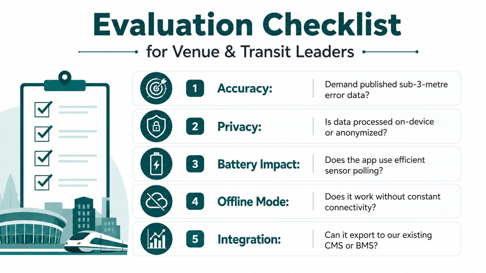
A procurement team should test a motion sensor app as a service, not buy a list of technical features. Start with accuracy due diligence. Ask for published evidence from independent trials, the route lengths used, the devices tested, the way errors were measured and the conditions under which the system loses confidence. A claim such as sub-three-metre guidance needs context, especially on long routes, around lifts and in magnetically noisy buildings.
Ask questions that expose operational risk
- Accuracy: How does the system bound drift on long journeys, and what happens when a user misses a turn?
- Accessibility: Can the supplier provide a WCAG 2.1 AA audit, Equality Act documentation and references from blind, partially sighted and mobility-impaired users?
- Map updates: How quickly can the operator add a new entrance, remove a closed lift or change a route after building works?
- Connectivity: Which functions work without GPS, Wi-Fi, Bluetooth or mobile data, and when is internet access required for setup or venue content?
- Privacy: Is motion processing performed on the device, what information leaves it, and how does the service apply data minimisation under UK GDPR?
- Integration: Can route content connect with existing venue information, customer support and content-management processes?
The operational workflow deserves as much scrutiny as the algorithm. Ask who supplies floor plans, who approves accessible routes, who tests instructions on site and who signs off changes. A venue with frequent tenant turnover needs a clear update process that doesn't depend on reinstalling physical equipment.
Define success before launch. Useful measures include step-error rate, time to destination, route drop-off, accessibility task completion and support requests. Compare the implementation and ongoing service costs with the alternative infrastructure model, but don't reduce the decision to installation cost alone. Hardware, surveys, battery replacement, site access and future layout changes all belong in the lifecycle assessment.
Waymap's implementation best-practice guidance can help frame the questions for a venue or transit programme. Waymap uses built-in smartphone sensors and dead reckoning for indoor and outdoor guidance, and Thomas Pocklington Trust's wayfinding-app guide describes the service as using phone sensors without signals or beacons while requiring internet access and venue sign-up in its comparison table.
A sensible pilot includes disabled users, varied phone-carrying styles, lifts, accessible entrances, noisy areas and route changes. It should also test what happens when the app can't confidently determine the user's position. A graceful recovery instruction is more valuable than a confident but incorrect direction.
Waymap provides infrastructure-free, step-by-step navigation for indoor, outdoor and underground journeys using the motion sensors already built into standard smartphones. Visit Waymap to discuss accessible routes, venue mapping and a deployment approach suited to your transport network, campus or large public building.
