
Mapping 3D Software: A Practical Guide for Venue Operators
If you're staring at a glossy 3D estate model and the operations team still can't use it to answer a simple visitor question, you already know the gap this article is about. Mapping 3D software only matters when it turns a surveyed space into something people can work with, whether that's a transit hub, a stadium, a campus, or an underground interchange. The practical issue is rarely the model itself. It's whether the output fits the constraints of venue operations, accessibility, and navigation.
A transport operator or venue manager usually gets pulled into this work for one of two reasons. Either a survey has exposed a need for better spatial data, or a wayfinding problem has become too expensive to ignore. In both cases, the buying decision lives in the middle ground between procurement, IT, estates, and accessibility teams, which is where many projects stall.
What Mapping 3D Software Actually Does for Large Venues
A venue team can commission a beautiful 3D model and still end up with an asset nobody can act on. That happens when the deliverable stops at visualisation. Mapping 3D software should do more than render a space, it should organise spatial information so downstream systems can query it, update it, and use it in live operations.
The difference between a model and a usable spatial layer
A visual model is often enough for a presentation. An operational layer is what a navigation app, BIM workflow, or asset-management system needs. The useful output is structured, measurable, and tied to real coordinates, not just a nice-looking mesh.
That distinction matters in procurement. A venue operator doesn't buy a model because the concourse looks realistic. They buy it because they need staff, contractors, and visitors to make better decisions inside a space that changes often. Static signage can't keep up when tenant layouts shift, a platform changes access, or an event reconfigures circulation.
Practical rule: If the file can't support navigation-grade queries, it's a visual asset, not an operational one.
For event and venue teams looking at audience-facing spatial communication, the same logic applies to marketing for event venues, because a spatial layer only becomes valuable when it can support actual visitor behaviour, not just design review.
Why procurement teams get this wrong
The main failure mode is buying a surveyor's deliverable and expecting an operations tool. Those are not the same thing. Survey outputs can be excellent and still be wrong for wayfinding, accessibility support, or live asset management.
The better question is simple, what does the data need to do after capture? If the answer is route people, support as-built verification, or feed a digital twin, then the software has to preserve coordinate integrity, model structure, and enough accuracy for the use case. That is also why venue teams increasingly need to think beyond the capture event and toward the update workflow, especially where infrastructure-heavy signage is hard to maintain.
For operators comparing navigation layers, Waymap's approach is relevant because it works as an infrastructure-free option alongside 3D spatial data, rather than as another static map. That makes the model's job clearer, the model doesn't have to carry every operational burden on its own.
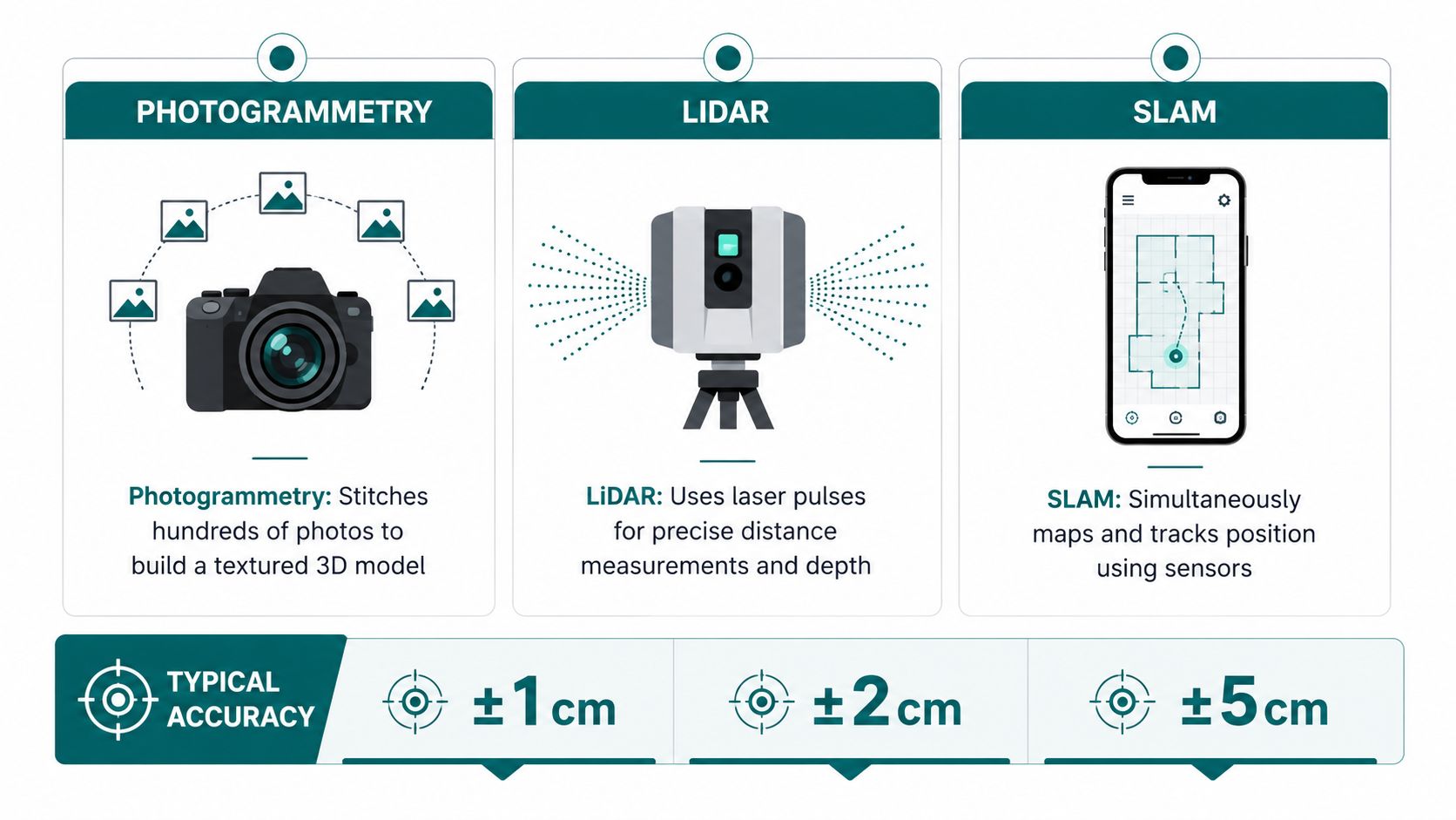
How Photogrammetry, LiDAR, and SLAM Capture 3D Spatial Data
Choosing photogrammetry, LiDAR, or SLAM is mostly a question of environment and tolerance for disruption. The wrong choice can produce a model that looks complete but collapses when you need precision at a platform edge, in a stair core, or across a long concourse. The right choice depends on whether you care more about texture, distance measurement, or live capture while moving.
Photogrammetry works when texture and lighting are your friends
Photogrammetry is often the method people understand first. You take many overlapping photos, then software stitches them into a textured 3D model. It works well when the environment has enough visual detail for the software to match features between images.
That makes it useful for visible architectural surfaces, façades, and many public-facing interiors. It's less forgiving when surfaces are repetitive, reflective, dark, or poorly lit. A polished station wall or a low-texture corridor can make the reconstruction less stable than the marketing language suggests.
LiDAR is the stronger choice for distance and geometry
LiDAR uses laser pulses to measure depth directly, which makes it more reliable where texture is weak or the space is large and complex. In transport and venue settings, that often means corridors, service zones, structural frames, and underground or partially lit areas. A single scan can capture geometry that cameras struggle to resolve cleanly.
The trade-off is that LiDAR captures geometry very well, but it doesn't automatically give you a rich visual surface. You still need processing and alignment if you want the output to be useful beyond raw measurement. For teams evaluating indoor capture workflows, our 3D LiDAR scanning guidance is useful because it separates the scanning method from the business result.
SLAM is what makes mobile capture practical
SLAM, or simultaneous localisation and mapping, lets a moving device build a map while it tracks its own position. That's the mechanism behind many mobile indoor mapping workflows and the foundation for infrastructure-free navigation. The value is speed and flexibility, especially when a venue can't stop operations for tripod-based capture.
It isn't a magic fix. SLAM is only as good as the sensor package, the environment, and the processing chain. But for multi-level public spaces where layouts change and access windows are short, it often beats slower methods on operational reality even when the geometry is not the absolute tightest possible.
Indoor Versus Outdoor 3D Mapping Workflows and Data Sources
Indoor and outdoor mapping solve different problems, and treating them as one workflow is where many projects get messy. Outdoors, you can lean on GPS, satellite imagery, and airborne LiDAR for broad coverage and absolute positioning. Indoors, that support disappears, which is why a corridor, mezzanine, or underground station requires a different capture logic.
The data sources are not interchangeable
Outdoor mapping usually starts with drones, terrestrial scanners, and georeferenced terrain data. The UK's long shift from 2D cartography to high-resolution digital terrain and urban models has been anchored by Ordnance Survey's OS Terrain 5 and OS Terrain 50, which provide nationwide elevation data at 5 m and 50 m resolution respectively, supporting 3D visualisation, line-of-sight analysis, and location-based applications across Great Britain. The public-sector direction of travel is also visible in the National Underground Asset Register rollout led by the Geospatial Commission, which reflects how seriously the UK now treats 3D and subsurface mapping in planning and infrastructure decisions.
Indoor mapping starts somewhere else. You're usually working with smartphone sensors, handheld LiDAR, or SLAM capture in GPS-denied conditions where signal continuity can't be assumed. The practical consequence is that a transit hub often needs both workflows stitched together, one for the exterior approach and one for the internal environment.
Operational reality: If your venue spans open-air, concourse, and underground space, one capture method rarely covers all three cleanly.
RTK and PPK are not the same choice
For outdoor capture, the correction method matters. RTK can work well when cellular coverage is stable, but it can fail in poor-coverage environments. PPK is the more reliable option when coverage drops out, which is why it's often better for long campuses, rail corridors, and underground-to-surface projects.
That distinction matters for procurement. A team might specify “high accuracy” without asking how the model stays accurate when the connection fails or the route moves underground. The system's value is not just what it does when conditions are perfect, it's what it keeps doing when they aren't.
A single venue needs a stitched spatial picture
A station, arena, or hospital campus rarely exists as one neat capture zone. The exterior approach, ticket hall, corridors, lifts, platforms, and adjacent public realm all behave differently. That's why the mapping workflow should be planned as a connected chain, not a one-off survey event.
For teams building navigation services, our GPS indoors explanation is relevant because it clarifies why indoor wayfinding can't depend on the same assumptions as outdoor positioning. The important procurement question is whether your spatial data chain supports both environments without forcing the user to notice the handoff.
Hardware and Processing Requirements That Determine Project Success
Most 3D mapping failures do not happen in the field. They happen when the workstation cannot keep up with the dataset. In practice, mapping software becomes memory and CPU bound before it becomes disk bound, so the capture plan and the machine spec need to be set together.
The workstation is part of the workflow
Published guidance for Autodesk AutoCAD Map 3D lists Windows 10/11 64-bit, a 2.5 to 2.9 GHz processor, and 8 GB RAM as the minimum, with recommended configurations rising to 3+ GHz CPU and 16 GB to 32 GB RAM depending on the reseller or specification source Autodesk AutoCAD Map 3D system requirements. For heavy venue-scale or city-scale work, that is only the floor.
A mapping workstation should be chosen for the dataset you expect to process, not the one you hope to process later. The practical guide in the brief points toward 32 GB RAM minimum and 64 GB or even 128 GB for heavy workloads, with a recent i7 or i9-class CPU and an NVIDIA-class GPU preferred for reconstruction tasks. For teams that are testing workflows before buying full production hardware, a room scanner app can help narrow down whether the capture process is likely to stay within a manageable processing envelope before the bigger workstation spend lands. That is the difference between a usable processing queue and a bottleneck that stalls the entire project.
Accuracy needs a measurable reference
A 2024 ISPRS Annals indoor mapping study tested a cloud-based image platform against ground truth using 30 sample lines on generated meshes, and reported no significant differences in mean errors with the cloud-based mesh producing minimal errors ISPRS Annals study. A separate construction study reported that Autodesk Recap generated the most stable and highest-quality dense point clouds, that DroneDeploy could create an accurate point cloud and triangulation without using as many points as COLMAP and LiMapper, and that the software outputs were positively and linearly correlated with the ground-truth model construction software comparison.
A compact rover surveying and laser-scanning BIM study in PMC found reconstructed results were quite accurate compared with the actual design and that the measurement error did not exceed 2% of the ground truths PMC BIM study. Those are the kinds of tolerances procurement teams should ask vendors to meet, because “looks good” is not a testing method.
| Study | Method | Key Finding |
|---|---|---|
| ISPRS Annals 2024 | Indoor 3D mapping against ground truth | 30 sample lines were tested, with no significant differences in mean errors and minimal errors |
| PMC rover surveying study | Compact rover surveying and laser-scanning BIM | Reconstruction was quite accurate and measurement error did not exceed 2% of the ground truths |
The hardest part is often not the scan. It is keeping the coordinate chain intact from capture through model. A workflow article in the brief makes the requirement explicit, every point needs to be anchored to a global coordinate system with absolute latitude, longitude, and elevation so the output can function as a verifiable digital twin global coordinate system requirement.
For security-conscious estates teams, the same discipline applies when spatial data sits alongside systems discussed in NHS compliant security systems, because the mapping platform has to fit the operational environment, not just the visual one.
The practical takeaway for procurement
If a vendor cannot explain their correction method, coordinate handling, and workstation requirements in plain language, they probably have not tested the system in a hard environment. That matters for NHS estates managers facing capital spend restrictions, and it matters for transport operators who do not want to buy hardware that collapses under a full-concourse dataset. It also matters for venues that need a 3D asset they can refresh without re-surveying everything from scratch.
Turning 3D Spatial Data into Accessible Navigation
A 3D model is only useful for accessibility if it can feed a real navigation layer. That means the spatial data has to support route logic, point-of-interest updates, and reliable positioning in places where GPS and signage both struggle. The gap between “we have a model” and “people can find the right door” is where most estates programmes underdeliver.

Spatial data only matters when users can act on it
Wayfinding systems need more than geometry. They need the data to be updated quickly enough for real-world change, and they need the positioning logic to work in infrastructure-poor environments. That is why infrastructure-free navigation has become such a practical answer for transit stations, shopping centres, hospitals, and campuses with frequent layout changes.
Waymap's approach uses device-native motion sensors and dead reckoning so it can deliver sub-3-metre accuracy in infrastructure-free environments without Bluetooth beacons, Wi-Fi, or GPS. The operational benefit is straightforward, staff do not have to maintain a network of physical devices across a high-footfall estate. That matters when the site changes often and the hardware burden would otherwise sit on the operations team.
Named deployments show why this matters. Waymap has been deployed at Lord's Cricket Ground, described in the brief as the first stadium in the world to implement the technology, and it has also been deployed at WMATA in Washington DC, SBS Transit in Singapore, and the Royal Hospital for Children and Young People. Those are different environments, but the operational friction is similar, lots of movement, difficult signal conditions, and a need for guidance that survives change.
The legal context matters too. Equality Act 2010, ADA Title III, and BS EN 17210 all push organisations toward access that is reliable in practice, not just compliant on paper. That is especially relevant in underground stations and multi-level venues where a user can't depend on a phone signal or a sign being visible from the right angle.
The integration layer is the real work
A useful 3D model can support accessibility only if the downstream application can interpret it. That's where teams often underestimate the effort, especially if they assume a model exported from one package will behave cleanly in another. Front-end teams building 3D web apps with React understand this problem well, because spatial data only becomes useful once the application layer can consume it properly.
The point for decision-makers is not that every venue needs a custom app. It's that the model, the route data, and the navigation engine have to speak the same language. If they don't, the result is another isolated file instead of a usable mobility layer.
Our turn-by-turn navigation overview is useful background here, because it shows how route logic turns spatial data into instructions people can follow. That's the standard venue and transit teams should be thinking about, not just the map.
Selection Checklist and Common Pitfalls for 3D Mapping Procurement
A good procurement spec for mapping 3D software is less about brand names and more about failure avoidance. The questions below catch most of the problems that show up later in delivery, especially in estates, transport, and public-sector environments where the cost of rework is high.
Five questions to ask before you buy
- Capture technology fit. Does the vendor's method work in your environment, or does it depend on ideal lighting, stable coverage, or empty spaces?
- Data accuracy. Can the output be checked against ground truth, not just judged visually?
- Software usability. Can your team operate it without creating a new specialist bottleneck?
- Integration. Will the output connect to navigation, BIM, or asset-management systems without repeated manual rework?
- Support and scalability. Can the vendor support a larger estate, a changing layout, and future updates without forcing a platform change?
The capture question is the one frequently under-specified. A model built for open outdoor geometry may not survive a dense indoor environment. Likewise, a system that works in one terminal doesn't automatically generalise to a campus with mixed surfaces, signal loss, and moving people.
The mistakes that cost the most
The first common pitfall is buying a visual model that can't support navigation-grade queries. The fix is to ask for the coordinate logic and downstream data structure up front. The second is underestimating the cost of maintaining beacon infrastructure in a high-change venue. The fix is to compare hardware maintenance against infrastructure-free alternatives before committing to install hardware everywhere.
The third is ignoring RTK versus PPK in areas where coverage drops out. The fix is to name your environment accurately, especially if part of the route goes underground or into a signal-poor transition zone. The fourth is failing to specify accuracy tolerances in the procurement document. The fix is to define what acceptable means for your use case, then insist on measurement against ground truth.
If your estate changes often, the wrong procurement decision isn't just expensive. It creates a second operations problem that lasts for years.
For public-sector teams, our public sector procurement guidance is relevant because the buying process has to account for change, not just initial delivery. NHS estates managers, transport operators, and retail venue teams all face different friction points, but the shared rule is the same: buy the data chain you'll use.
Frequently Asked Questions About Mapping 3D Software
Can mapping 3D software work without GPS or Wi-Fi?
Yes, it can work without GPS or Wi-Fi if the workflow uses device sensors, SLAM, or dead reckoning. That matters in underground stations, indoor venues, and other signal-poor environments where navigation still has to function.
How accurate do indoor 3D models need to be for navigation?
They need to be accurate enough to support route decisions and coordinate integrity, not just visual realism. For navigation-grade use, the model has to stay tied to a global coordinate system with absolute latitude, longitude, and elevation.
What's the difference between a 3D model and a digital twin?
A 3D model shows shape, while a digital twin is a verifiable spatial asset that can support operational decisions. The difference is whether the data can be queried, updated, and trusted for real use.
How long does a large venue 3D mapping deployment take?
There isn't a single standard timeline, because the capture method, access window, and integration scope all change the schedule. A venue with mixed indoor and outdoor zones will usually need more coordination than a simple single-space scan.
Does accessibility law really affect mapping software choice?
Yes, because standards like the Equality Act 2010, ADA Title III, and BS EN 17210 create demand for guidance that works reliably in the real environment. That's why infrastructure-free navigation is often a better fit than a model that depends on fixed hardware everywhere.
If you're comparing mapping 3D software for a venue, campus, or transit environment, Waymap can help you turn spatial data into navigation that works indoors, outdoors, and underground without beacons or GPS. Visit Waymap to see how our platform fits estates, accessibility, and wayfinding programmes that need to survive real operational change.
