
LNER Trains Map: Plan Your East Coast Journey 2026

If you've got an LNER route map open on your phone while standing at King's Cross, the main question usually isn't where the train goes. It's how you get from concourse to platform, from platform to lift, or from arrival hall to the next operator without losing time or confidence. That gap between a route map and a usable journey is where most passengers run into friction.
The LNER trains map matters because LNER is not a niche regional operator. The original LNER was created by the Railways Act 1921, began operating in 1923, and became the second-largest of the Big Four after the LMS, helping shape the East Coast corridor that still defines travel patterns today, according to the historical record in the LNER account of the railway group's formation. The modern LNER operator runs most services on the East Coast Main Line and remains part of a major national intercity network, with route coverage and customer guidance anchored on LNER's own destinations page and National Rail's operator listing. LNER destinations page and National Rail's LNER operator listing
Why the LNER Trains Map Only Solves Half the Journey
A passenger arrives at London King's Cross with a printed map that shows Edinburgh, York, Leeds, Newcastle and the rest of the East Coast spine. The map is accurate, but it doesn't answer the immediate questions that matter in the station. Which entrance is closest to the accessible route, which platform has the right lift access, and which corridor avoids the longest walk when you've got a tight connection?
That's the central problem with an LNER trains map search. People often think they need a line diagram, when they really need station-level wayfinding. The distinction matters most at busy interchanges such as King's Cross, Leeds, Newcastle, and Edinburgh Waverley, where route planning and platform navigation are separate tasks.
Practical rule: a route map tells you where the service runs, but the station layout tells you whether you'll actually make the connection in time.
The East Coast Main Line is the backbone of LNER's network, so the map is still essential. But for real journey-making, the useful picture includes named stations, interchange points, accessible entrances, and the transfer logic between operators. That's why a good map workflow needs route coverage first, then corridor breakdowns, then station-level navigation, not the other way around.
How to Find and Download the Official LNER Route Map
The most reliable starting point is LNER's destinations page, because LNER points customers there for route coverage, timetables, fares, and journey information. National Rail is the second checkpoint, especially when your journey crosses into another operator's territory or when you need a neutral source for service updates. If you want a baseline document before you travel, those are the two places to use first.
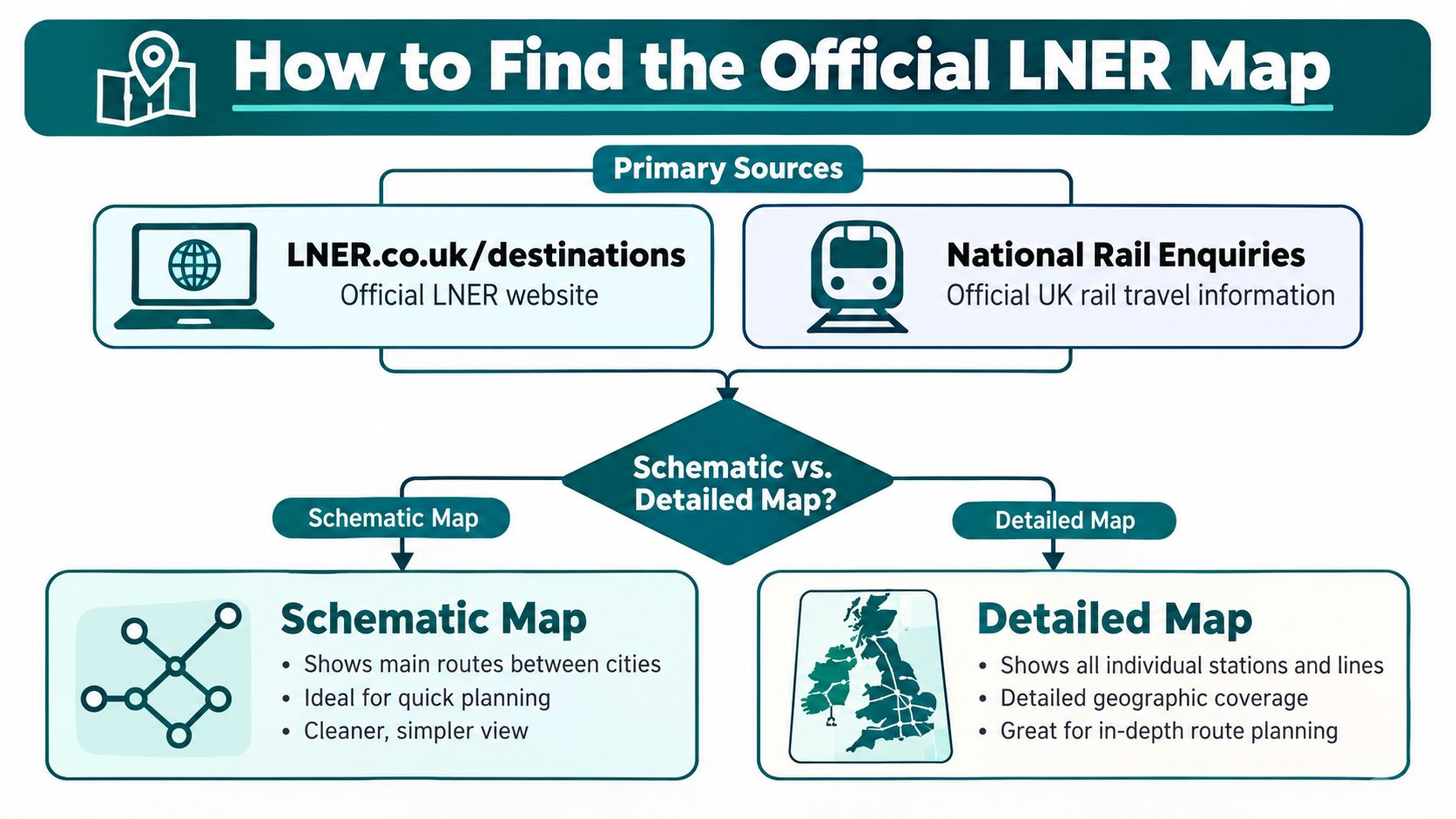
Read the map type before you read the stations
A schematic route map shows the network as a service diagram. It is designed to help you understand line structure, named stops, and interchange relationships, not physical geography. A geographic map shows the corridor in its real-world shape, which is more useful when you need to understand how far a station sits from a city centre, a tram stop, or a second rail operator.
For offline use, download the PDF version before you travel. That matters on longer East Coast trips, where signal quality can be patchy and you don't want to rely on live loading at the exact point you need the map. If your journey extends beyond LNER's direct service area, cross-reference the map with the relevant connecting operator so you don't assume a through-connection that isn't there.
For event-style journey planning, I also recommend comparing the map with Creventa's event resources, especially when you're coordinating time-sensitive arrivals around station access, venue opening times, or group movement. For a practical internal example of how corridor mapping gets presented for passengers, see Waymap's C2C train map article.
Use the official route page for structure, then use live journey tools for timing. A static map never tells the whole truth by itself.
East Coast Main Line Corridors and Key Station Lists
LNER's current network is built around a single long-distance spine, but passengers don't experience it as one line. They experience it as a series of corridors with different interchange behaviour, different station forms, and different onward options. That's why a corridor view is more useful than a flat route diagram.
| Corridor | Principal Stations | Key Interchanges | Connecting Operators |
|---|---|---|---|
| London to Yorkshire | London King's Cross, Stevenage, Peterborough, Grantham, Newark North Gate, Retford, Doncaster, York | King's Cross for Underground and other rail lines, Peterborough for cross-country connections, Doncaster for regional links | Thameslink, Great Northern, CrossCountry, Northern, Hull Trains |
| Yorkshire to North East England | York, Thirsk, Northallerton, Darlington, Durham, Newcastle | York for wider York rail links, Darlington for regional connections, Newcastle for Metro and local rail | TransPennine Express, Northern, CrossCountry, Tyne and Wear Metro |
| North East England to Edinburgh | Newcastle, Morpeth, Berwick-upon-Tweed, Dunbar, Edinburgh Waverley | Newcastle for urban interchange, Edinburgh Waverley for city-centre transfer and Scottish connections | ScotRail, CrossCountry, Lumo, Tyne and Wear Metro |
| Scottish extensions | Edinburgh Waverley and selected onward Scottish connections | Edinburgh Waverley for onward Scotland travel | ScotRail |
The modern LNER operator runs most services on the East Coast Main Line in the UK and is a state-owned train company, which is why the map today is part of a national intercity network rather than a historic curiosity. That operational reality shows up in the station list. Some places are pure through-stops, while others are transfer hubs where passengers split off to regional or local services.
The practical question is not just where LNER stops, but which stations function as handover points. York and Doncaster often matter for regional branching. Newcastle matters because it turns rail interchange into urban access planning. Edinburgh Waverley matters because the station itself is part of the city's geography, not just a place to board a train.
For passengers planning a London to Edinburgh journey, Split My Fare's London to Edinburgh guide can help with ticket structure and route comparison, but the station map still has to be checked separately if accessibility or transfer speed matters.
Major Interchange Stations and Transfer Complexity
The biggest mistake I see passengers make is treating every interchange as if it behaves like a simple platform swap. It doesn't. King's Cross, Leeds, Newcastle, and Edinburgh Waverley each create a different kind of transfer burden, and the station design often matters more than the timetable.
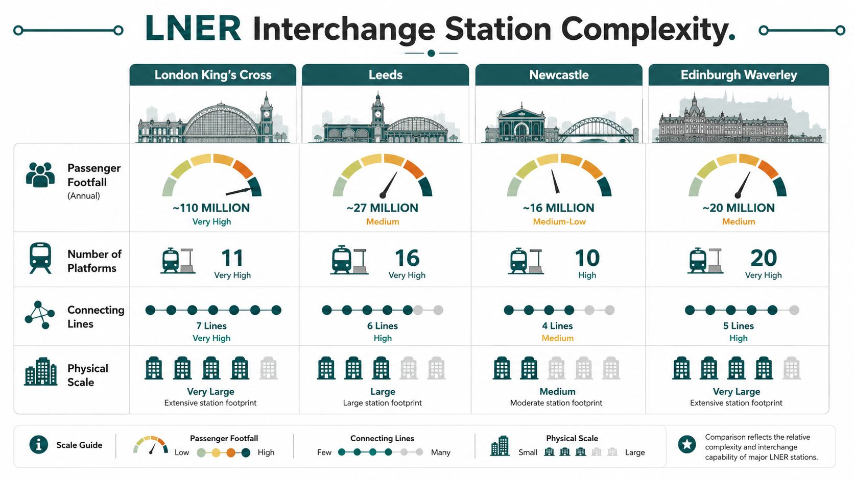
What makes each station harder or easier
London King's Cross is the most important LNER gateway, but it's also a complex place to move through because it sits close to other major rail functions. Passengers connecting to Thameslink or Eurostar-related travel need to think about station adjacency and walking routes, not just the train line.
Leeds is awkward for a different reason. The station's layout makes platform choice and vertical movement part of the transfer problem, especially when connecting between local and intercity services. It's the sort of place where the shortest timetable connection can still be the wrong real-world choice if the route requires a long walk or a level change.
Newcastle adds a city-interchange layer because of the Metro relationship. If your onward journey leaves the East Coast corridor, your transfer isn't just from one train to another, it can be from national rail into a light rail network with its own access points and station logic.
Edinburgh Waverley is a city-centre station with a very particular topography. The old and new town context makes the station feel integrated into the city, but that also means the walking and lift routes can be less intuitive than they look on a schematic map.
For a different station-design reference point, the contrast between major rail interchanges is handled well in Waymap's Shinjuku station map article, because the core issue is the same, translating a large transport node into a usable route for the passenger.
Transfer rule: if a station has lifts, multiple levels, or a second operator nearby, never judge it by line distance alone. Judge it by walking complexity.
The Last 50 Metres Problem at LNER Stations
A lot of people searching for an LNER trains map are not really searching for a route diagram. They're trying to solve the last part of the journey, the bit between arrival and platform, or between the concourse and a lift, or between the ticket hall and the correct accessible route. That's the last 50 metres problem, and it's where static maps fail most often.
LNER serves 54 stations across the East Coast Main Line and directly manages 11 stations, so the practical problem is rarely “does the train go there?” It's “can I move through the station safely and predictably when I get there?” That question gets sharper when a lift is out of service, a platform changes, or construction closes a familiar corridor. In those moments, a printed map or a saved PDF can be technically correct and operationally useless.
The same issue shows up with step-free travel. Accessibility information exists, but it is often separated from the route diagram that most passengers start with. That separation creates avoidable friction for wheelchair users, blind and low-vision passengers, and anyone who needs turn-by-turn reassurance in a large station.
For a practical navigation example that focuses on instructions rather than diagrams, see Waymap's navigation instructions article. The lesson is simple. A station map is only useful if it reflects the route a passenger can take on the day they travel.
Step-Accurate Accessible Navigation for LNER Journeys
LNER's accessibility channels are designed around assisted travel contact routes and regulated support hours, with National Rail's operator listing standardising customer support availability from 08:00 to 22:00 daily. That gives passengers a formal route for arranging help, but it doesn't automatically solve the movement problem inside the station. The best practice is to book assistance early, then pair that booking with a navigation tool that can guide the last part of the walk.
A strong accessible journey plan starts with three checks. First, confirm the route map and station names. Second, confirm the access route at the origin and destination. Third, check whether the station environment is likely to change between booking and travel, because temporary platform changes can affect the path you need to take.
What precision navigation adds
For station movement, Waymap uses dead reckoning with device-native sensors to provide step-accurate audio and on-screen directions without relying on GPS, Wi‑Fi, or installed hardware. That matters in complex rail interchanges because the user needs guidance indoors, at platform level, and through places where signal or infrastructure can't be assumed. A relevant real-world example is its deployment at Lord's Cricket Ground, which shows how the same kind of venue-scale wayfinding can support movement through a dense, changing environment.
The compliance angle matters too. The Equality Act 2010 creates a duty to make reasonable adjustments, and an infrastructure-free navigation layer fits that requirement better than a static map alone when station layouts change. For teams managing route planning, Waymap's walking pattern recognition article is a useful reference for how precision guidance adapts to the user, not just the venue.
If the station layout changes faster than the signage can, the wayfinding layer has to move with the passenger, not wait for hardware refreshes.
Verifying Timetables and Real-Time Service Changes
The safest way to use an LNER trains map is to treat it as the first step, not the final authority. LNER's own destinations page points passengers to LNER.co.uk and National Rail Enquiries for journey information, and that division matters because live status can change after you've already left home. A map tells you the network shape. It does not tell you whether today's platform plan still holds.
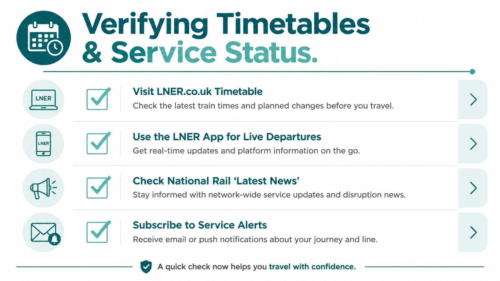
A simple check sequence that holds up in practice
Before departure, confirm the journey on LNER.co.uk or the LNER app so you're working from the most current operator guidance. During the journey, use National Rail for cross-operator disruption details when a connection depends on more than one company. On arrival, check station notices or platform updates before you walk off the train, because temporary changes are often local and immediate.
That matters most for passengers who depend on step-free access. A lift outage or a temporary closure can make the “obvious” path unusable, even when the timetable still looks fine. If you're changing at a station with multiple levels or long corridors, real-time confirmation is not optional.
For operations teams and journey planners, Waymap's real-time transit information article shows why live updates belong beside the map, not after it.
Why Operators Must Layer Dynamic Wayfinding Over Static Maps
Transport operators keep paying for the limits of static maps. The physical signage has to be maintained, the platform logic has to be updated, and the station layout keeps changing because of engineering works, retail changes, and accessibility fixes. Bluetooth beacons and other installed hardware can help, but they also create a maintenance burden in high-footfall stations where the environment isn't stable for long.
Why the infrastructure-free model matters
An infrastructure-free wayfinding layer avoids that problem by using the smartphone itself as the navigation device. Waymap's approach relies on motion sensors fused with detailed maps, so venues with frequent layout changes do not need a fresh hardware build every time a corridor shifts or a boarding area moves. That makes it a better fit for rail stations than tools that depend on fixed beacons.
The regulatory case is straightforward. Equality Act 2010 duties and BS 8300 accessibility expectations both push operators toward usable, reliable navigation for people who can't depend on visual signage alone. Static maps help, but they don't replace live wayfinding when the station changes after a printed map has already gone out of date.
There's also an operational and ESG case. If passengers can move through the station more confidently, they're more likely to keep using rail for the whole journey, and that supports the operator's wider sustainability story. The best accessibility investment is often the one that reduces maintenance friction while improving passenger confidence at the same time.
Quick Reference Checklist for Accessible LNER Journey Planning
Before you travel, use this checklist as a final control pass. It's the quickest way to turn the LNER trains map into a journey you can complete without avoidable stress.
- Review the route map first. Confirm the exact LNER stations you need, then check whether your journey stays on the East Coast corridor or needs a connecting operator.
- Check step-free access at both ends. If you use a wheelchair, mobility aid, or need lift access, don't assume a station's main entrance is the accessible one.
- Book Passenger Assist early. LNER and National Rail both direct passengers to formal support channels, and that booking should be in place before travel, not after you've reached the station.
- Download offline information. If the route passes through areas with weaker signal, save the map and timetable before you leave.
- Confirm platform details close to departure. Temporary platform changes can make an otherwise sensible connection harder to complete.
- Use precision navigation at the station. For blind and low-vision passengers, audio guidance is the missing layer. For cognitive accessibility needs, clear turn-by-turn directions reduce the burden of interpreting a large station layout.
For teams comparing live journey tools, logivo.ai's live fleet visibility feature is a useful reference point for how real-time operational information can support passenger confidence, especially when service conditions shift.
Passenger rule: if the station is large, layered, or changing, never rely on the map alone. Pair it with live status and step-level navigation.
Frequently Asked Questions About the LNER Trains Map
Does the LNER trains map include connecting operators? Yes, but only as part of the wider station and corridor picture, not as a full map of every other operator's network. Use LNER.co.uk and National Rail Enquiries to verify the connecting leg.
Where can I find step-free access information for a specific station? Check the station's accessibility details through National Rail and LNER's journey information pages, then confirm whether the route you need is step-free on the day you travel.
What should I do if my interchange station has a temporary accessibility restriction? Recheck the station status before departure, contact Passenger Assist, and plan an alternative route through the station if the lift or access path is out of service.
Does LNER provide real-time platform navigation inside stations? No, not as a complete station navigation layer. For inside-station guidance, passengers need live station information and a navigation tool that can guide the last part of the trip.
Is the LNER trains map enough for an accessible journey? No, it's only the starting point. An accessible journey needs the route map, live timetable checks, station access information, and a last-50-metres navigation plan.
If you're planning LNER travel and need a station experience that goes beyond a static route map, Waymap provides step-accurate navigation for complex environments where platforms, entrances, and transfer paths matter. It's built for journeys like this, where the route is only half the task and the station itself is the ultimate test.
