
Accuracy Solutions for Indoor Navigation That Work

You're standing in a station concourse or a venue foyer, the map on the wall looks right, and yet the person following your navigation prompt still ends up at the wrong platform edge or the wrong entrance. That gap is what accuracy solutions are meant to close. For transit and estates leaders, the question isn't whether a system can produce a location point, it's whether it can get people to the correct door, platform, lift bank, or point of interest when the environment is noisy, crowded, and changing.
Accuracy Solutions for Indoor Navigation That Work
What Accuracy Solutions Have to Actually Deliver
A blind passenger moving through a busy interchange doesn't need a neat coordinate on a screen. They need the guidance to survive the whole journey, from street to concourse to platform, without dropping them at the wrong branch or making them re-orient at every turn. That is the difference between a demo and a usable accuracy solution.
The practical promise is simple, but the execution isn't. A system has to keep the user aligned to the right path, preserve guidance through indoor, outdoor, and underground transitions, and stay usable in a crowded space where audio, attention, and confidence are all under pressure. Wayfinding only works when the guidance remains correct at the moment the user has to make a choice, not just at the first fix. What location services really mean for navigation
Practical rule: if a traveller can reach the right destination only when they already know the building, the system isn't solving accuracy, it's outsourcing the problem to the user.
Accuracy is an outcome, not a single reading
Operators often inherit vendor language that treats accuracy as one coordinate error in metres. That's too narrow for stations, campuses, airports, and stadiums. In those settings, the more useful test is whether the route ends correctly and whether the handoff between segments holds together. Waymap's note on magnetometer accuracy
The Office for National Statistics Data Strategy, launched in October 2020, is a useful public-sector precedent here because it framed data quality around accuracy, coherence, and timeliness and tied those standards to operational decisions across public services. The ONS also reported 94.6% online completion in England and Wales for the 2021 census in its published material, which shows how digital collection can improve completeness and reduce manual processing error compared with paper-heavy workflows. In other words, accuracy is already treated as a governed capability when the consequences matter. ONS Data Strategy and census context
For transit and venue operators, the takeaway is direct. If the system can't get the user to the correct destination in the environment, then the accuracy claim isn't operationally meaningful, whatever the dashboard says.
Defining Accuracy in Navigation and Positioning
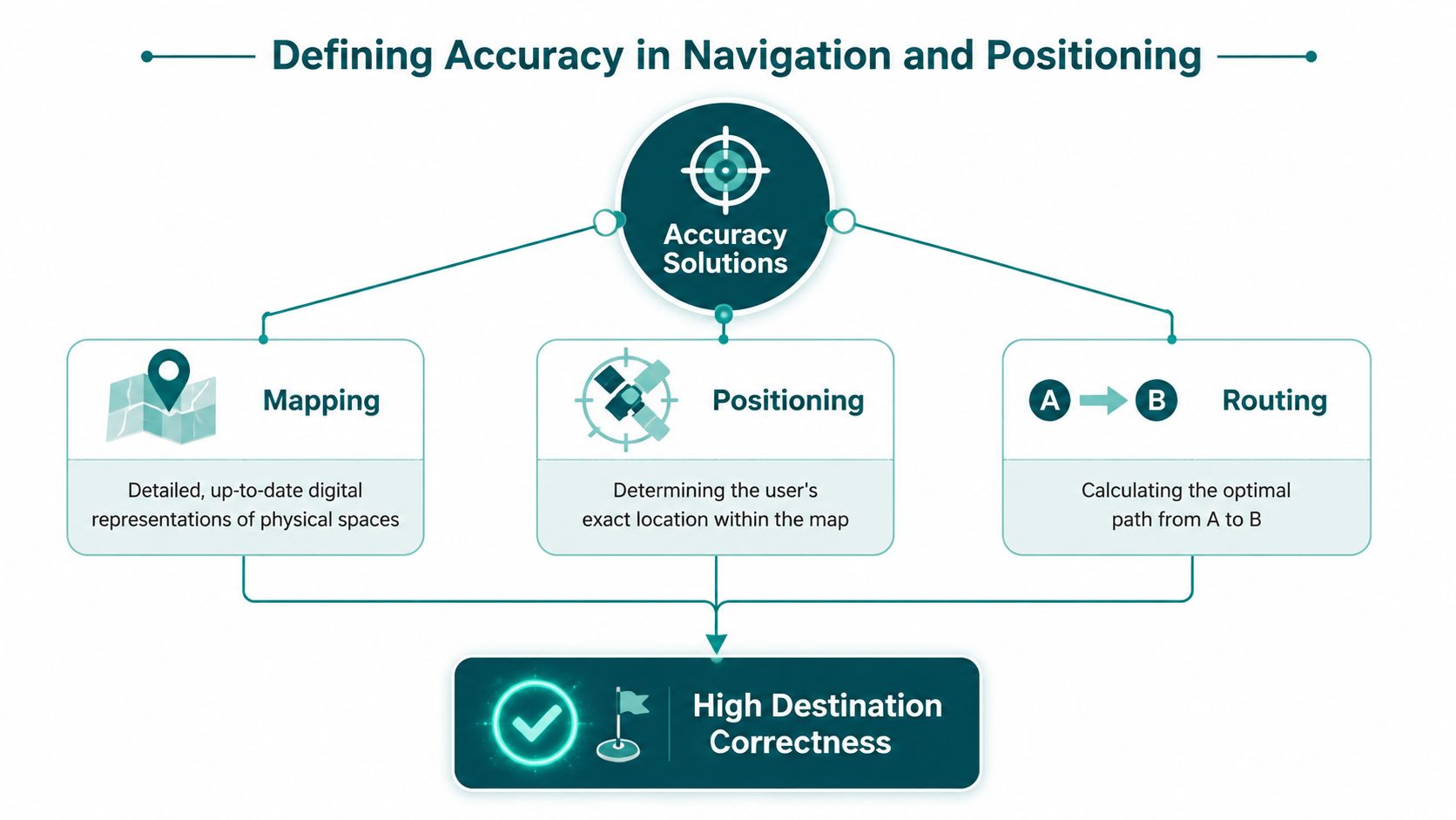
Accuracy solutions combine mapping, positioning, and routing so that a person moves from A to B with high destination correctness. That definition matters because most vendor pitches stop at a single coordinate point and never explain what happens in the final metres, where people choose the platform, door, or exit.
There are three dimensions that matter in practice. First is positional drift, the gradual loss of alignment as the person keeps walking and turning. Second is destination arrival correctness, which asks whether the user reaches the right final place, especially in the last 5 to 20 metres where small errors become real failures. Third is handoff reliability, the ability to preserve guidance as the person moves between outdoor, indoor, and underground spaces.
Why a meter figure can mislead buyers
A low coordinate error can still produce a poor journey if the map is stale, the path graph is wrong, or the handoff fails at a stair, lift, or branch point. A system can look strong in a lab and still misroute users at the decision point. That is why the more useful language is destination-level and journey-level accuracy, not just sensor precision. Waymap's indoor location tracking overview
This framing also fits the UK public sector mindset. The ONS example above shows that accuracy is treated as formal governance, not branding. Public bodies already depend on shared datasets for address validation, transport planning, and service delivery, so even small error rates can compound at scale.
For buyers, the shared vocabulary should be straightforward. Ask whether the product maintains alignment, whether it lands users at the correct destination, and whether it keeps working through the full route. If a vendor can't answer those three questions clearly, the spec sheet is probably hiding risk.
Technical Approaches and the Trade-offs Behind Them
Different positioning methods fail for different reasons, and the trade-off that matters most is usually not just accuracy. It's the cost of putting the system into the building, keeping it working, and updating it when the layout changes. That burden lands hardest on estates and transport teams, because they already manage high-footfall environments with frequent changes.
How the main approaches differ in practice
GNSS-derived positioning works well outdoors because it uses satellite signals, but it becomes unreliable indoors and underground. Wi-Fi fingerprinting can work in some indoor spaces, but it depends on a maintained radio environment and regular recalibration. Bluetooth beacons can improve indoor guidance, but they require installed hardware and ongoing maintenance. Ultra-wideband can deliver strong precision in controlled settings, yet it also depends on infrastructure and careful deployment. Device-only sensor fusion uses the phone's own motion sensors and map data, which removes the need for fixed hardware and is better suited to environments where retrofits are hard.
The right question isn't which method sounds most advanced. It's which one keeps working after the building changes, the concourse gets crowded, or the operator can't justify another maintenance cycle.
Comparing Indoor Positioning Approaches for UK Venues
| Approach | Typical accuracy | Infrastructure needed | Maintenance burden | Best fit |
|---|---|---|---|---|
| GNSS-derived positioning | Strong outdoors, weak indoors and underground | Satellite-dependent, no internal install | Low on-site, poor coverage in signal-poor spaces | Street-level navigation |
| Wi-Fi fingerprinting | Variable, depends on environment stability | Existing wireless environment | Medium to high, because maps and signals drift | Controlled indoor estates |
| Bluetooth beacons | Can support indoor guidance | Installed beacon layer | High, due to hardware upkeep and battery management | Smaller managed zones |
| Ultra-wideband | High in controlled deployments | Dedicated installed infrastructure | High, because deployment and calibration are involved | Precision-critical areas |
| Device-only sensor fusion | Designed for indoor, outdoor, underground continuity | No installed venue hardware | Low on-site, because the venue avoids retrofits | Transit, campuses, stadiums, airports |
The main reason UK teams hesitate over infrastructure-heavy approaches is simple. Each extra layer adds capital spend, installation time, and calibration work, and those are exactly the friction points that slow accessibility programmes down. For places like rail stations, airports, universities, shopping centres, and stadiums, the technology has to fit the operating model, not just the map.
Why Sensor Fusion Without Beacons Is the Practical Answer
A good infrastructure-free system starts with the phone the user already has. It reads the device's native motion sensors, estimates walking direction, and updates position against a detailed map graph, then adapts that model to the person's stride and movement pattern. That's pedestrian dead reckoning in plain language, and it's the reason this approach can keep working where GNSS, Wi-Fi, and Bluetooth struggle. Waymap's mapping and navigation overview
Why this matters in signal-poor places
Underground concourses, lift banks, enclosed circulation routes, and crowded atria are the exact places where conventional location methods become unstable. The user isn't asking for a perfect academic model, they're asking not to be lost at the branch point. A sensor-fusion system can correct drift against the indoor map and adapt as the person walks, which is what makes it useful in real transport estates and large venues.
Waymap's approach is built around that operating reality. It uses the smartphone's native sensors with detailed indoor maps, and its published product materials describe guidance at around 3 feet and 10 degrees of heading using just a smartphone, without infrastructure. For a venue operator, that matters because the final turn and final doorway are where users decide whether the route worked.
The trade-off buyers should understand
No system escapes drift entirely, so the engineering question is how fast it corrects and how well the map supports correction. High-resolution building maps and gait adaptation reduce cumulative error by keeping the user anchored to the route rather than asking for a new calibration at every section. That's why infrastructure-free doesn't mean lower ambition, it means the location layer is designed to fit a changing estate instead of demanding a new hardware project for every change.
For venues with frequent layout changes, that is the difference between a navigation layer that ages well and one that starts failing as soon as the floorplan shifts.
Accuracy as an Accessibility and Compliance Requirement
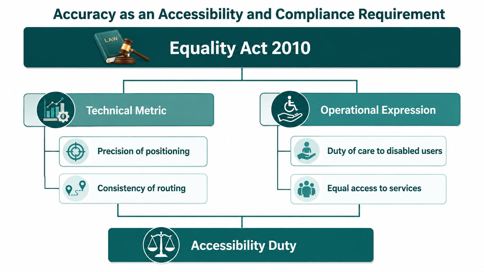
For UK operators, accuracy isn't only a technical question. It's the practical expression of a legal duty to make services usable for disabled people. The Equality Act 2010 is the anchor here, because it places a duty on service providers to make reasonable adjustments for disabled users in premises and services. Equality Act 2010 overview
Why compliance changes the definition of good accuracy
A navigation system that loses the route in a long corridor or misreads a platform transition can't reliably support equal access. That matters because accessibility in the built environment is judged at the point of use, not at the point of design. Standards such as BS 8300, PAS 78, and BS EN 17210 reinforce that expectation by pushing operators toward usable, inclusive environments rather than token compliance.
The practical issue is the one estates and transport teams already know. If a user can't get accurate step-by-step guidance to the lift, platform edge, accessible toilet, or entrance, then the operator still carries the accessibility gap. A technology layer only helps if it performs through the crowded, noisy, signal-poor parts of the journey where the decision is made. Accessibility testing and practical navigation
Why infrastructure-light systems fit the duty better
The compliance argument is also operational. A hardware-heavy scheme can make reasonable adjustments harder to sustain because every extra beacon, tracker, or radio layer adds a maintenance dependency. An infrastructure-light navigation layer is easier to keep current across changing estates, and it supports the kind of destination accuracy that disabled travellers need without forcing the venue into constant retrofits.
There's also an ESG angle. A single inclusive navigation layer supports broader social sustainability reporting because it improves access without fragmenting the estate into separate assistive systems. In practice, that means one well-run layer can serve compliance, visitor experience, and public-sector equality outcomes at the same time.
A Selection Checklist for Evaluating Accuracy Solutions
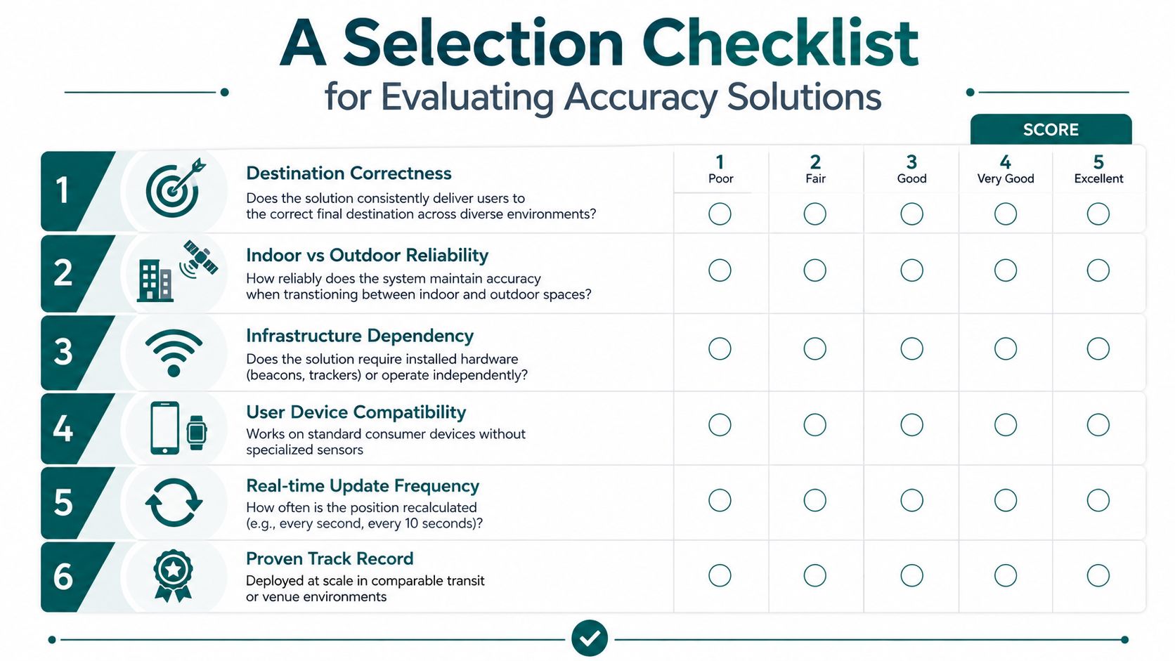
A procurement conversation gets much clearer when the questions are concrete. Buyers should not start with “how accurate is it?” They should start with “does this system get people to the right place, in the building, without adding operational pain?”
The questions that actually predict success
Destination Correctness. Does the solution consistently deliver users to the correct final destination across different spaces? A weak answer usually focuses on a single coordinate number and avoids the arrival point.
Indoor vs Outdoor Reliability. Does the system hold together when the user moves between street, building, and underground? If the vendor only talks about one environment, expect handoff failures.
Infrastructure Dependency. Does it require beacons, trackers, or installed radios, or does it work independently? If the answer includes a long install project, the maintenance burden is already showing.
User Device Compatibility. Can it run on standard consumer smartphones without specialist kit? If not, adoption usually narrows fast.
Real-time Update Frequency. How often does it recalculate the position and refresh the route? Slow updates can leave the user chasing the map instead of following it.
Proven Track Record. Has it been deployed at scale in comparable transit or venue environments? A lab demo is not evidence of operational fit.
A useful internal test is whether a non-engineer can update a point of interest quickly when a shop changes, an entrance moves, or a lift goes offline. If the answer is no, the system will age badly in a live estate.
How Named Operators Use Accuracy Solutions in Practice
At WMATA in Washington, DC, the challenge was not abstract positioning theory. Retrofitting beacons across a historic metro network would have added an operational layer that was hard to justify and hard to maintain, so an infrastructure-free approach made more sense. The point was to preserve usable guidance without opening a hardware programme every time the network changed.
At SBS Transit in Singapore, the important constraint was platform-edge accuracy in a busy interchange. That is exactly where positional drift becomes a user-facing problem, because a small error at the wrong branch can send someone to the wrong side of the station. In that kind of environment, the product has to stay aligned through turns, level changes, and crowd pressure.
Lord's Cricket Ground added a different kind of test. A stadium route has to work on a matchday, when entrances, seat blocks, and step-free routes matter more than a clean map view ever will. The first stadium deployment of Waymap showed how destination accuracy turns into something a board recognises, getting a visitor to the right seat, the right entrance, and the right accessible route.
Operators don't buy navigation tech because it sounds clever. They buy it when the route holds up under their worst operational day.
From Procurement to Operation and What Comes Next
The strongest accuracy programmes share three traits. They avoid hardware sprawl, they treat accuracy as part of accessibility and ESG rather than a sensor spec, and they insist on destination-level outcomes instead of coordinate-only claims. That combination matters because it reduces maintenance burden while improving the experience for people who need the route to be right the first time.
The question to take into your next vendor meeting is blunt. Can your system get my passenger to the correct platform edge, lift, or door, every time, without my team installing or maintaining hardware?
That's the standard that turns inclusive design into operational advantage. When the route is accurate, the estate becomes easier to use, easier to support, and easier to defend in compliance conversations.
If you're assessing accuracy solutions for a station, campus, airport, or stadium, we can walk you through how Waymap works in indoor, outdoor, and underground environments, and what it means for compliance, maintenance, and visitor experience. Visit Waymap to see how infrastructure-free navigation can fit your estate and start a conversation with our team.
