
Abu Dhabi Grand Prix Circuit Map: A Visitor's Guide
Yas Marina is a 5.281 km, 16-turn permanent circuit on Yas Island, with the start and finish straight, main grandstands and Yas Marina itself anchoring the map. The current Formula 1 layout runs for 58 laps, covering a race distance of 306.183 km.Formula 1's official Yas Marina circuit information
You're probably looking at a coloured circuit diagram, trying to work out whether your grandstand is near the right gate, whether a taxi can reach it, and how you'll get back after the podium. That's the wrong way to use the Abu Dhabi Grand Prix circuit map. Yas Marina is a live venue with blocked routes, moving crowds, marina-side bottlenecks and different access patterns for each stand.
Read it as a visitor's navigation plan, not a driver's lap chart. The useful map tells you where to enter, which side of the circuit you're on, what you can see from a seat, and how to reach the same point when GPS or mobile signals become unreliable.
Reading the Yas Marina Circuit Map Before You Travel
If you arrive at Yas Marina with only a coloured track diagram, you can still end up at the wrong gate, on the wrong side of the circuit, or facing a long walk after the podium. Read the Abu Dhabi Grand Prix circuit map as a race-day navigation tool. It should answer four practical questions: where you enter, which routes lead to your grandstand, what landmarks confirm your direction, and how crowds change those routes.
Start with the venue's broad geography. Yas Marina sits on Yas Island between the airport approach roads and the marina channel. The circuit is a broad, permanent venue rather than a temporary street course, and its 5.281 km lap wraps around several distinct arrival and viewing zones.
The track is a 16-turn, counter-clockwise circuit, with the main straight as the southern reference edge. Place the start and finish line at the bottom of your mental map. The pit lane and Main Grandstand run along that side, while the marina curves around the northern section. The W Abu Dhabi hotel, formerly the Yas Viceroy, crosses the circuit near the route toward the back straight, so it is one of the clearest landmarks on a printed diagram.
Use four fixed landmarks
Mark these points before choosing transport or planning your walk:
- The main straight: Your southern anchor, containing the start and finish line, pit lane and Main Grandstand.
- Yas Marina: The northern water-side reference, especially useful near the marina corner complex and North Grandstand.
- W Abu Dhabi: The hotel separates marina-facing areas from outer approach routes and is easy to spot.
- Yas Mall: The western arrival reference, close to parking, entertainment areas and fan activity.
Read the map like a clock face. The Main Grandstand is the lower edge, Yas Marina forms the upper curve, and Yas Mall marks the western approach. That orientation makes gate letters, taxi zones and shuttle arrows easier to interpret when the official map uses venue terms instead of city directions.
Practical rule: Choose your arrival side before choosing your seat. A stand that looks nearby may require a long circuit-side transfer if you enter through the wrong gate.
Do not expect a blue location dot to guide you through every indoor or signal-poor section. Waymap's guide to whether GPS works indoors explains why a static map and live position marker may not be enough inside complex venues. Save the official map offline, identify your gate and grandstand before race day, then check your position against the marina, hotel and mall. That infrastructure-free method keeps your route usable when signals fail and crowd movement blocks the obvious path.
Sectors and Corners of the Abu Dhabi Grand Prix Layout
Use the corner sequence as a routing tool, not just a way to identify turns. The 2021 redesign removed the Turn 5 to Turn 6 chicane and Turn 7 hairpin, replacing them with a single widened hairpin. Turns 11 to 14 became one sweeping banked curve. The lap is now faster and more continuous, with a long straight that concentrates overtaking and crowd interest. The Abu Dhabi Grand Prix layout changes are documented in this circuit reference
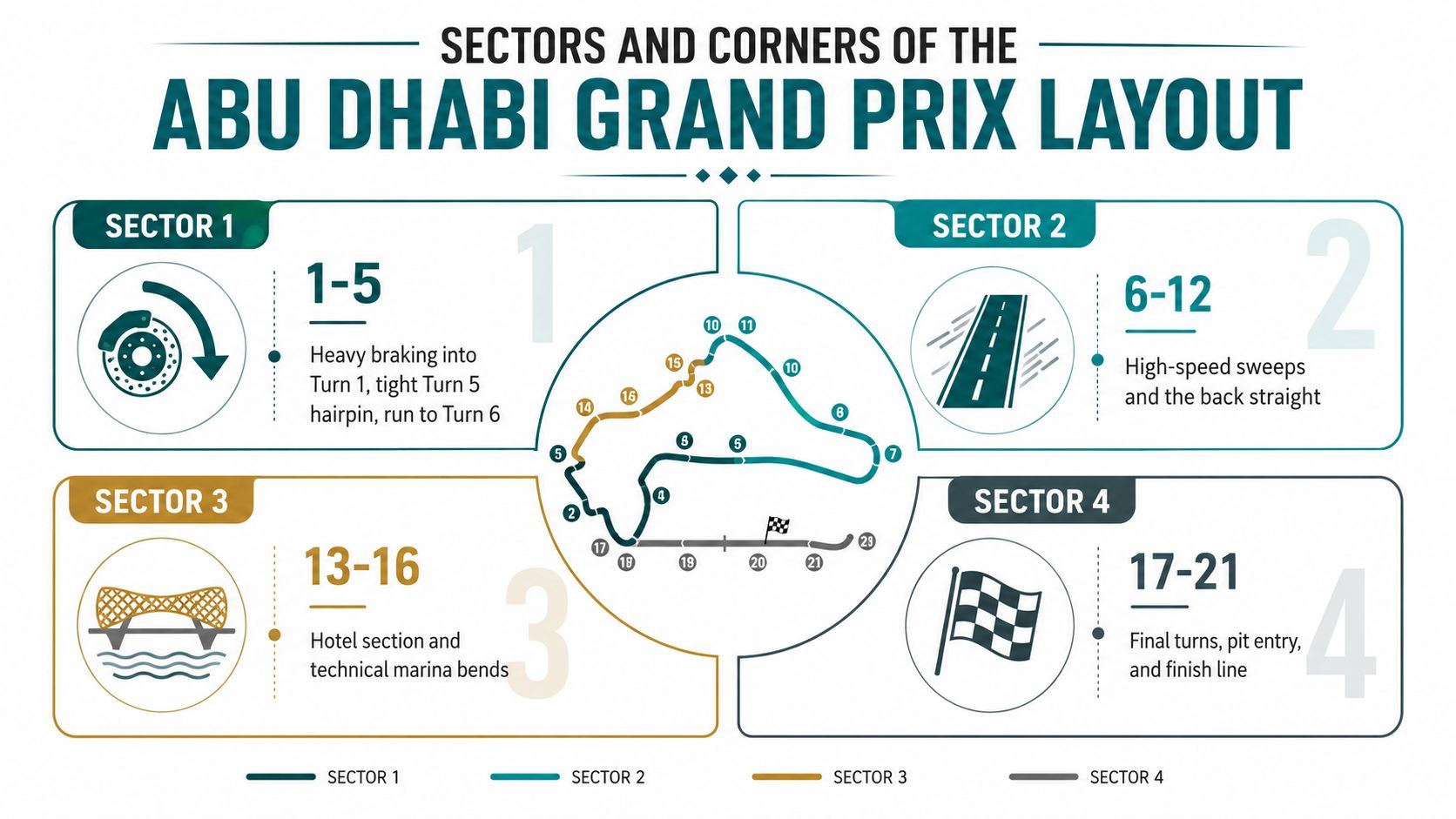
Sector 1: choose braking and acceleration
The opening sector runs from the hard braking at Turn 1 through the early corners towards Turn 5. Choose a viewing area here if you want to watch cars arrive at speed, brake sharply and contest position through a compact sequence.
The widened hairpin near the sector's end is particularly useful for reading race movement. From nearby viewing areas, you can follow the braking phase, corner exit and acceleration towards the W Abu Dhabi section. It also becomes a practical reference point when you are deciding whether to continue around the circuit or leave before the main crowd surge.
Sector 2: the strongest visual landmark
The marina-side complex around Turns 8, 9 and 10 is Yas Marina's defining image. Yachts, floodlights, the hotel and the track share the same view, making this the clearest choice for photographs and atmosphere.
Turn 9's banked profile also changes what you see from the stands. Cars hold a faster, more continuous line instead of stopping for one obvious braking event. Expect heavier foot traffic around this area because the major grandstand, hospitality spaces and the venue's most recognisable scenery sit close together.
Sectors 3 and 4: plan the return route
The run between the marina and the slower corners forms a major movement corridor for both cars and spectators. The straight between Turns 5 and 6 is identified as a major overtaking zone by Formula 1's United Arab Emirates race information, so this area suits fans who prioritise passing attempts, acceleration and late braking over marina views.
The final technical turns return the lap to the main straight and pit entry. They also affect your exit plan. After the session, large numbers of spectators leave nearby stands together, so a route that looks short on the diagram can become slow at gates, crossings and shared paths. Set your next destination before the chequered flag, and follow the circuit perimeter rather than cutting across unfamiliar facilities.
If you organise your own karting or motorsport event, the same separation between spectator circulation, access zones and active areas applies. Guidance on how to manage go-kart race events offers a useful comparison for arranging clear movement routes.
For a separate example of a circuit layout treated as a visitor-routing problem, compare this Melbourne F1 track guide. At Yas Marina, memorising every corner is unnecessary. Mark the feature that matters to your day, braking, acceleration, marina scenery or the final return to the line, then connect it to your gate and seat.
Best Grandstands and Viewing Spots on the Map
The best grandstand depends on what you want to see, not on which stand looks largest in a ticketing graphic. Yas Marina offers distinct viewing experiences, and the circuit map is useful only when you connect each stand to its corners.
| Grandstand | Map Location | Covers | Best For |
|---|---|---|---|
| Main Grandstand | Main straight | Start, pits, finish and podium activity | Race starts, pit-lane views and ceremonies |
| North Grandstand | Marina side | Turns 8 to 10 | Marina scenery, hotel views and atmosphere |
| South Grandstand | Southern infield side | Turns 2 to 5 | Braking, hairpin action and close racing |
| West Grandstand | Near the back section | Turn 12 area | Overtaking and slower-corner battles |
Choose the Main Grandstand for the event
The Main Grandstand is the safest choice if this is your first Abu Dhabi Grand Prix. You're facing the start and finish, pit lane and podium ceremonies, and higher rows give a broader view towards the opening braking zone.
The compromise is that the cars are at their fastest on the straight and disappear quickly. You'll rely on screens and circuit commentary to follow much of the lap, but you'll get the strongest sense of the race as a complete event.
Choose North for setting and South for action
The North Grandstand gives you the defining Yas Marina image. The marina, yachts, hotel and track sit in the same visual field, particularly around the Turns 8 to 10 complex. It's the right choice for atmosphere, photography and a venue experience that feels unmistakably Abu Dhabi.
The South Grandstand is more practical for watching cars work. It covers the early sequence and hairpin area, where braking and traction make the action easier to follow than a high-speed straight.
The West Grandstand is the blunt recommendation for fans who care most about overtaking. Its position near Turn 12 places you close to a recognised passing area, although the overall view is less iconic than the marina.
For venue operators planning maps, entrances and accessible seating across large sports sites, Waymap's guidance for stadiums and sports venues is relevant because a seat location is only useful when visitors can reach it without guesswork. The F1 Fan Zone, Yas Mall rooftop and Ferrari World terrace can add partial sightlines and screens, but don't treat them as substitutes for a ticketed grandstand view.
Getting to Yas Marina by Car, Shuttle, Taxi and Metro
Arrival is the point where a static circuit map stops being useful. Yas Marina sits approximately 8 to 10 km from Abu Dhabi International Airport and around 30 km from downtown Abu Dhabi, yet the event perimeter, gate controls and internal walking routes can make the final approach feel much longer. Use those distances for the city-to-island leg, then plan the gate-to-seat route separately.
If you drive, follow signs for the designated Yas Island parking areas. Do not expect to park beside your grandstand. Yas Mall or Yas Plaza is the practical map anchor, followed by an official shuttle or a substantial walk to the correct gate. Check the race-weekend transport plan before leaving. Road closures and access controls can change the route on the day.
Match transport with the grandstand side
| Arrival Mode | Drop-off / Parking | Best Suited Grandstand Side | Typical Transfer Time |
|---|---|---|---|
| Car | Yas Mall or Yas Plaza parking areas | Main, West and general circuit approaches | Allow a substantial walk or shuttle transfer |
| Race-day shuttle | Yas Mall and official shuttle stops | North, South, West and Marina clusters | Depends on queue and circuit-side routing |
| Taxi or Careem | Designated North Gate or West Gate zones | Main and north or west grandstand areas | Depends on road controls and queueing |
| Metro or island rail access | Yas Mall-side access point | Visitors continuing by shuttle or walking route | Short connection from the transport stop |
The closest metro-style access is on the Yas Mall side, not beside every grandstand. Treat that stop as your arrival anchor, then follow the signed transfer route. Yas Express links major Yas Island destinations and can save you from walking around the full perimeter in heat and crowds.
Your final route depends on crowd movement as much as distance. Queues usually build after the podium and concert activity, so leave before the main rush if you want a taxi. Tell the driver the exact gate or official passenger zone, not only “Yas Marina Circuit”. A wrong-side drop-off can put you on a long detour around restricted track areas.
For UK visitors flying through Dubai, separate airport orientation from venue access. The Dubai International Airport maps help with the first navigation problem. Before departure, pair them with the Abu Dhabi event transport map and mark your parking area, transfer stop and gate. That simple sequence prevents the common mistake of reaching Yas Island without knowing how to cross the event perimeter.
Accessibility Routing from Gate to Seat
Treat Yas Marina's accessibility route as a gate-to-seat plan, not a line on a static diagram. Confirm the accessible seating area and the gate assigned to your ticket before race weekend. The circuit's visitor guidance identifies West and East Gates as transport points for grandstands, notes wheelchair ramps on Yas Mall shuttle buses, and directs mobility questions to the AskYAS information point.
The disability-access information also confirms reserved seating for disabled visitors, with booking available through WhatsApp or telephone. If your ticket does not show the exact entrance or transfer route, contact the organiser before travelling. Do not wait until you reach the circuit.
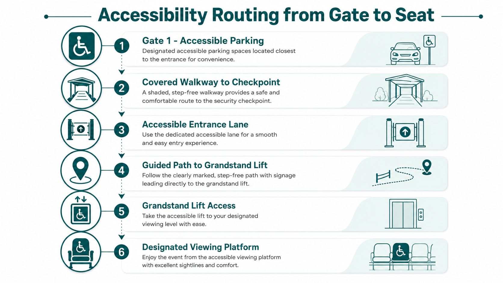
Use the official access points as anchors
Build the route around these landmarks:
- Arrive at the designated accessible gate. Follow the gate printed on your ticket or transport instruction, rather than joining the nearest general queue.
- Ask for the mobility transfer point. West and East Gates are useful map anchors, and staff can direct you to the correct grandstand vehicle or pedestrian route.
- Confirm the final stand entrance. A buggy drop-off point may be separate from the entrance serving accessible seating.
- Find toilets and companion seating early. The concourse is easier to cross before the race begins.
- Save the return route. Post-race crowd control may send departing visitors through a different corridor.
Facilities vary by grandstand and event setup. Ask the venue team to confirm ramps, toilets, companion positions and rest areas for your ticket. A generic circuit map cannot confirm those details.
Waymap provides one option for turn-by-turn indoor and outdoor guidance. Its infrastructure-free system uses a smartphone's motion sensors and detailed maps instead of GPS, Wi-Fi or installed beacons, which can support route-following in areas with weak signal. The principles of inclusive design apply beyond the seat itself. A usable plan must connect the gate, transfer point, entrance, facilities and viewing position clearly. Save those landmarks before entering, then check each one as you move through the venue.
Decoding Race-Day Map Symbols and Crowd Flow
The map legend isn't decoration. It tells you which routes are public, which areas are controlled and where the crowd is expected to move. Read every coloured line as an instruction about behaviour, not merely as a visual boundary.
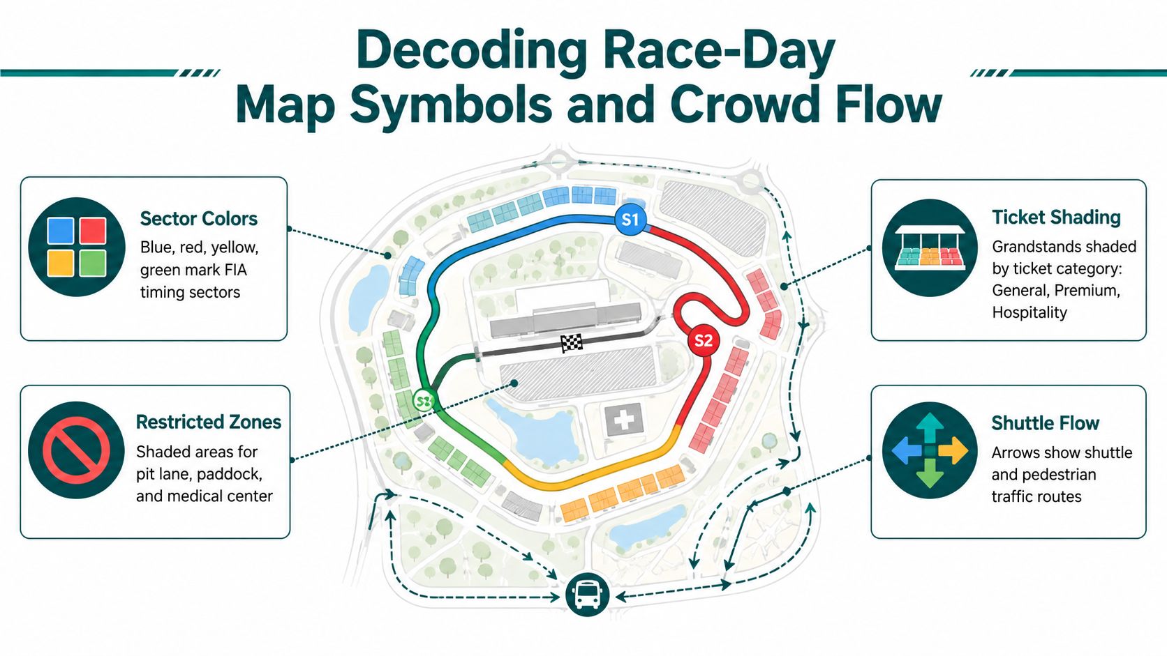
What the common symbols mean
- Sector colours: These identify timing sectors for the race, not necessarily public walking zones.
- Ticket shading: Different grandstand or ticket categories may appear in contrasting blocks. A nearby stand can still be inaccessible without the correct credential.
- Restricted shading: Pit lane, paddock, team areas and operational zones are controlled. Don't assume a quiet red or shaded area is a shortcut.
- Shuttle arrows: These show intended transport movement. They don't guarantee immediate boarding, especially when queues form.
- Pedestrian corridors: These are the routes the venue expects fans to use, often through gates, bridges and underpasses.
The area around the main grandstand bridge can look like a tempting crossing on a static map. It isn't a public shortcut when staff, team members or event operations are using it. Follow the signed fan route even if the alternative appears visually shorter.
Where the map stops reflecting reality
The underpass beneath the start and finish straight can compress pedestrian traffic. The F1 Fan Zone entrance near the North Gate, the marina walkway between the W Abu Dhabi hotel and Marina Grandstand, and the post-race route towards Yas Mall shuttles are all places where the obvious line can become slow.
The Yas Leisure Drive crossing may be shown as open on a map while event traffic makes it impractical at peak times. Use the circuit perimeter or a signed rear route instead of waiting for a crossing that is being managed by staff.
A route that is technically open isn't automatically a usable route. On race day, capacity and crowd control matter more than the line on the diagram.
Set a meeting point away from the busiest pinch points. If your group separates, don't tell people to “meet at the circuit”. Choose a named gate, mall landmark or information point that sits outside the moving crowd.
Building a Race-Weekend Plan from the Map
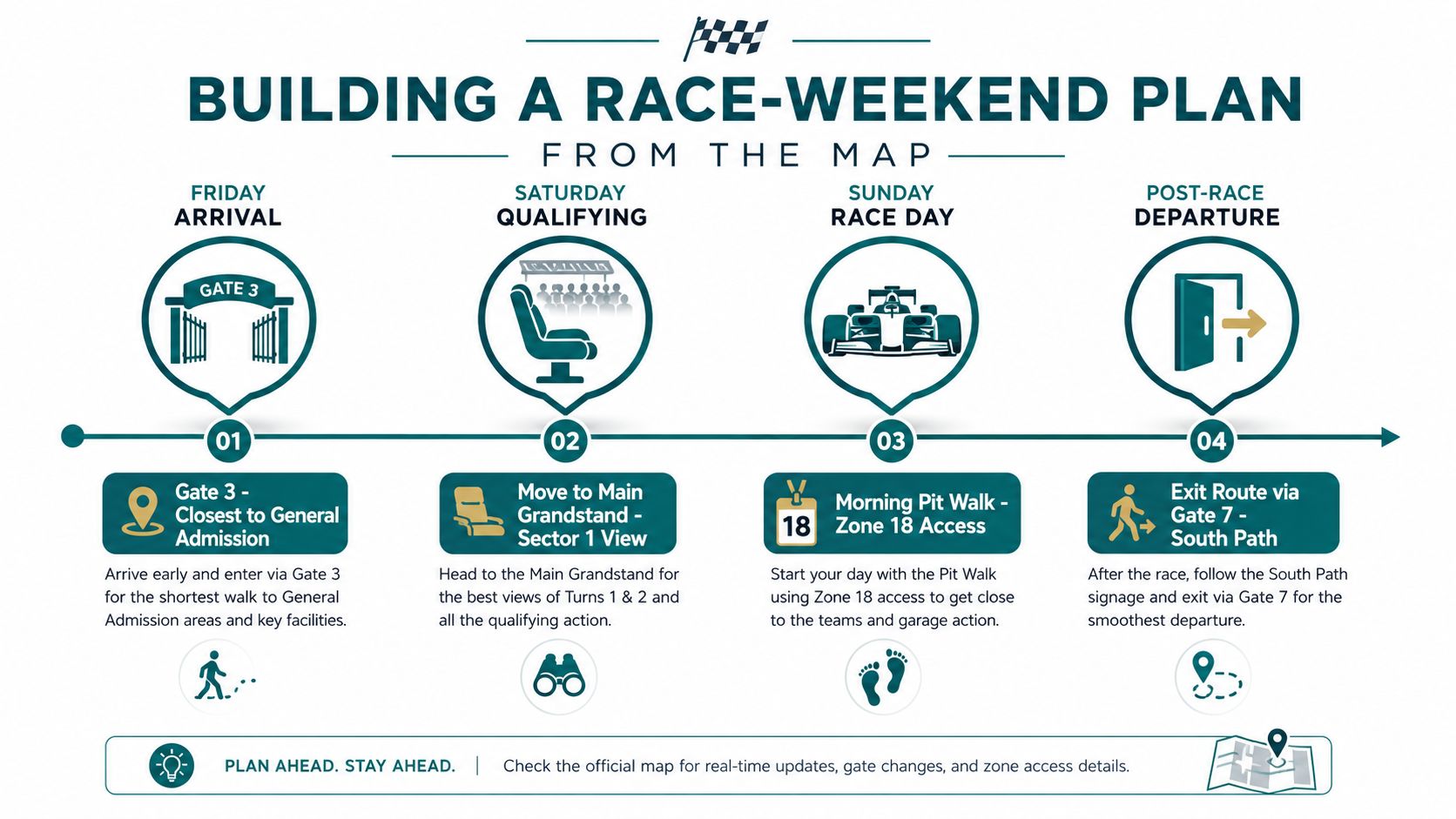
A good weekend plan makes one decision per day and avoids unnecessary crossings. Start by matching your ticketed area to the gate that serves it, then keep each day's activities on the same side of the circuit wherever possible.
Friday should be a route-rehearsal day
Use Friday to test the walk from your arrival point to the grandstand. Find the nearest toilet, accessible service desk, food area and exit route while the crowd is manageable. If you're in general admission, confirm the gate and the best open viewing area before settling in.
Don't spend the day crossing the circuit for every activity. Yas Marina's geometry makes backtracking tiring, particularly when bridges, controlled areas and one-way pedestrian routes limit your choices.
Saturday is for a deliberate viewing change
Qualifying rewards a clear view of a braking or acceleration zone, but you should leave enough time to reach a different grandstand or fan area. The Main Grandstand gives you the start-line context, while South or West-side positions provide closer views of cornering and overtaking.
The route matters as much as the destination. Use the map to identify the bridge or underpass you're allowed to take, then keep the group together through the transition.
Sunday requires an exit decision before the start
Choose your post-race route before the podium. If you're heading towards Yas Mall transport, move away from the main crowd as soon as the formal programme finishes. If you're using a taxi, confirm the designated rank and gate rather than trying to hail a car beside a closed road.
Concert and dispersal activity can change the feel of the venue after racing. The marina-side walkway may operate as a managed one-way route later in the evening, so don't plan to return by reversing your arrival path.
Abu Dhabi Grand Prix Circuit Map Questions Answered
Is Yas Marina a permanent Formula 1 circuit?
Yes. Yas Marina is a permanent circuit on Yas Island and hosted its first Formula 1 race in 2009. Its permanent layout is the right reference for planning entrances, grandstands and pedestrian routes.
How long is the Abu Dhabi Grand Prix circuit?
The current layout measures 5.281 km, includes 16 turns, and uses a 58-lap Grand Prix format. Treat those figures as orientation points, then use the event map for the day's gates and restricted routes.
Where should I stand to watch overtaking?
Choose a grandstand beside the long straight and its braking zone, especially around the Turn 5 to Turn 6 run. Formula 1 describes this roughly 1.2 km straight as a major overtaking area. On race day, arrive from the gate nearest your chosen stand instead of crossing the venue through the crowd.
Is the circuit accessible for wheelchair users?
Yes. Official visitor guidance identifies accessible transport, wheelchair-ramp shuttle buses and mobility support through AskYAS. Check the assigned entrance and step-free route before travelling, then confirm the accessible drop-off point with staff on arrival.
What does the circuit map show most clearly?
It connects the track with grandstands, gates, transport routes and restricted areas. Use it as a live movement plan, not just a diagram. Mark your gate, seat, nearest crossing and meeting point before crowds build.
Which map landmark should I use first?
Start with the Main Grandstand and start-finish straight. Then locate Yas Marina, W Abu Dhabi and Yas Mall. These fixed landmarks make the rest of the map easier to read, especially when one-way pedestrian routes alter your return path.
Waymap provides turn-by-turn indoor and outdoor guidance to venue doors, facilities and seating areas without GPS, Wi-Fi or installed hardware. Visit Waymap to assess infrastructure-free, step-free or audio-guided gate-to-seat planning.
