
Wayfinding Solutions That Actually Work Indoors
At 6:45 a.m., a transport or estates director sees a queue forming in a concourse. Three digital screens are dark, a temporary closure has moved the usual route, and a mobile map won't load underground. The immediate problem isn't a lack of maps. It's that the chosen wayfinding solutions can't survive the building they were bought to serve.
That distinction matters in hospitals, stadiums, shopping centres, airports, campuses, and rail interchanges. The right system must guide people through changing layouts, support different access needs, expose live route conditions, and remain affordable to operate after the launch team has gone. It must also fit capital approval cycles, hardware responsibilities, data governance, and accessibility obligations.
What Decision-Makers Actually Mean by Wayfinding Solutions
Wayfinding is the act of guiding someone from one location to another. Wayfinding solutions are the product category a buyer evaluates, including physical signs, digital signage, kiosks, mobile apps, maps, audio guidance, and indoor positioning.
A sign can point towards a platform. A kiosk can print a route. An app can provide turn instructions. A positioning system can determine where the visitor is. A credible deployment combines these elements around the decisions people must make, rather than treating each channel as an isolated purchase.
The practical test is simple. Can a visitor find the correct entrance, understand a diversion, reach a platform or department, and recover after taking a wrong turn? If the answer depends on one screen, one app download, or one piece of infrastructure remaining operational, the system is fragile.
Practical rule: Buy for the environment you have, not the demonstration environment vendors show you.
Static signage remains valuable because it works without a phone, battery, or network connection. It also becomes expensive to alter when a hospital department moves, a stadium changes its seating plan, or a station closes an entrance. App-only navigation has the opposite weakness. It can change quickly, but it assumes the user has a compatible device, sufficient confidence, and a working connection or positioning method.
The procurement question has therefore moved beyond “Can you provide a map?” It is “What guidance layer will remain accurate, accessible, and maintainable when the building changes?” Waymap's overview of app-based wayfinding is useful context for buyers comparing mobile navigation with fixed information channels.
Operators should also treat physical conditions as evidence, not background detail. In England, official disability and accessibility statistics for 2019/20 recorded satisfaction with pavements and footpaths at 46% among disabled people, compared with 56% among non-disabled people, while satisfaction with pavement condition was 46% versus 57%. Satisfaction with pavement obstructions was lower still, at 37% compared with 44%, as reported in the Department for Transport accessibility statistics. These figures describe the wider walking environment, but they make the procurement point clearly: people already encounter unreliable physical guidance before they enter a complex venue.
The Five Main Types of Wayfinding Solutions in Use Today
Buyers usually encounter five overlapping families. Each depends on different signals, hardware, and operating practices.
Static and dynamic signage systems
Static signs include directional boards, pictograms, tactile labels, colour bands, and maps. Dynamic systems add LED boards or electronic displays that can show changes, warnings, and rerouted destinations. They depend on visual legibility, correct placement, power for electronic elements, and a content process that keeps information current. Airports, rail stations, hospitals, and stadiums use them because visitors need guidance without first opening an app.
Kiosks and interactive totems
A kiosk provides a searchable directory, “you are here” location, route display, and sometimes printed instructions. It needs a powered screen, enclosure, network connection, cleaning, software support, and a location that people can reach without blocking circulation. Shopping centres, hospital foyers, and university buildings commonly use this model. It works well for visitors who want an overview, but it creates a queue when too few units serve a busy entrance.
Mobile and app-based navigation
Mobile wayfinding uses a smartphone interface, maps, audio, haptics, and positioning data. A white-label venue app may also include tickets, events, directories, and alerts. The hardware burden shifts to the user's phone, but the operator still needs map data, app maintenance, accessibility testing, and a reliable positioning method. Hospital campuses and large visitor destinations often use apps because the route can continue beyond the building entrance.
Digital signage networks
A signage network connects displays to a content management system. Operators can publish a closure, alter a destination, or manage crowd flow from a central interface. The system depends on screens, media players, power, connectivity, and a disciplined publishing workflow. Transit hubs and arenas benefit when operational teams need to coordinate passenger or visitor information across many decision points.
Infrastructure-free navigation
Infrastructure-free navigation uses device-native sensors, a building model, and software that estimates movement without installed beacons or venue Wi-Fi. The visitor's phone does the sensing, so the venue avoids a large hardware estate. It suits underground spaces, leased buildings, venues with frequent refits, and organisations that can't justify capital works for every route.
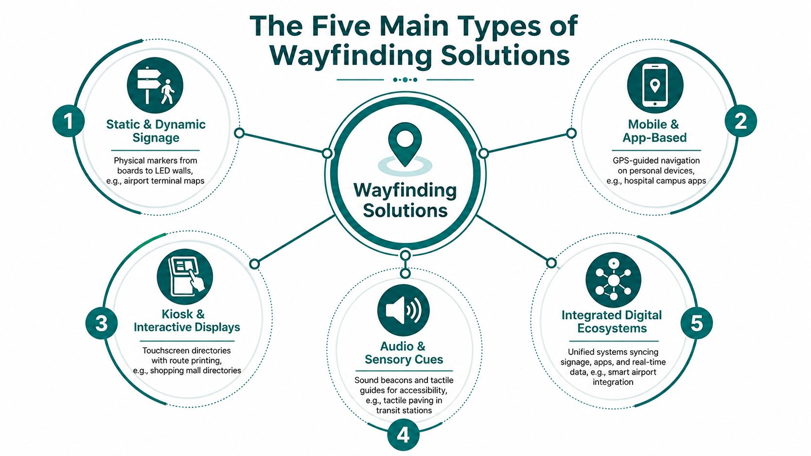
These families increasingly overlap. A content management platform may publish to screens and a mobile SDK, while a mobile app may reproduce static map imagery. The important buying decision isn't which label sounds modern. It's which combination keeps route information accurate, accessible, and affordable across the venue's operating life.
Indoor Positioning Methods Compared and Where Each One Breaks
Positioning is where most wayfinding projects become infrastructure projects. A vendor may promise a smooth blue dot, but the buyer is choosing who supplies the signal, who maintains it, and who pays when the environment changes.
| Method | Typical accuracy | Infrastructure burden | Where it breaks | Best-fit venue |
|---|---|---|---|---|
| BLE beacons | Room-level positioning | Installed beacons, surveys, battery replacement, density tuning | Batteries fail, steel and changing layouts affect coverage | Owned stations and long-lived campuses |
| Wi-Fi fingerprinting | Building-level positioning | Existing access points, radio surveys, network coordination | Access points move or network conditions change | Sites with stable managed Wi-Fi |
| Computer vision | Strong performance in mapped corridors | Cameras, visual references, imagery catalogue, compute | Refits, obstructed views, lighting and changed interiors | Controlled corridors and retrofit estates |
| Dead reckoning and sensor fusion | Route-relative positioning | Smartphone sensors and a building model | Poor map data, unusual movement, calibration issues | Leased, underground, and frequently changing spaces |
BLE beacons can be practical where an operator owns the estate and accepts a recurring maintenance programme. They require more than installation. Teams must monitor batteries, assess coverage, revisit surveys, and account for areas where construction materials interfere with the expected signal. A comparison of Bluetooth access points and indoor navigation helps frame why an apparently small hardware decision can become an estate-wide responsibility.
Wi-Fi fingerprinting reuses access points, which makes it attractive to IT teams. It also ties navigation to a network designed for connectivity rather than positioning. Repositioned access points, changed radio conditions, and altered floor layouts can make the fingerprint stale.
Computer vision can deliver strong results along mapped corridors, but it introduces cameras, imagery management, and compute overhead. A hospital that can't cable its estate may still accept that burden if it needs a retrofit approach and controls the relevant spaces.
Dead reckoning and sensor fusion run on the phone itself. The system estimates movement from sensors such as the accelerometer and gyroscope against a detailed building model. It removes installed positioning infrastructure, but it doesn't remove the need for accurate maps, route testing, and operational updates. For a venue with long depreciation cycles, beacons or Wi-Fi may be rational. For a leased or refit-heavy site, infrastructure-free indoor navigation usually presents the cleaner cost and maintenance profile.
Accessibility Standards That Now Shape the Procurement Conversation
Accessibility should decide the shortlist before the product demonstration. A system that provides directions but excludes screen-reader users, uses weak contrast, or sends people through inaccessible routes creates operational exposure rather than solving it.
The relevant framework depends on jurisdiction and channel. Buyers may need to consider ADA Title III in the United States, EN 17161 Design for All in Europe, the Equality Act 2010 in the UK, and WCAG 2.2 for digital interfaces. These standards don't turn every product into the same product. They require the operator to examine signage, interfaces, routes, content, and the experience of people with different impairments.
The UK transport evidence is direct. Transport for London's signage guidance specifies accessible blue, Pantone 3005, as the background for signs with white symbols, text, and borders, and recommends positioning signs at a consistent height of 1300 mm from floor level to the top edge, as described in the Customer Information Strategy for signage and wayfinding. UK pedestrian wayfinding guidance also recommends matt finishes or a gloss factor of no more than 15%, good lighting, high contrast, and consistent sign geometry. It says sites shouldn't rely entirely on colour coding.
| Wayfinding type | Primary standards | Key requirement |
|---|---|---|
| Physical signage | Equality Act 2010, inclusive mobility guidance | Legible contrast, suitable placement, tactile and accessible route information |
| Digital signage | WCAG 2.2, local equality duties | Readable content, contrast, clear hierarchy, non-colour cues |
| Mobile apps | WCAG 2.2, ADA Title III where applicable | Screen-reader support, audio and haptic guidance, accessible controls |
| Indoor positioning | Equality Act 2010, EN 17161, local requirements | Routes that reflect access needs and usable alternatives |
| Audio and sensory cues | Inclusive design guidance | Clear prompts without creating confusion or unsafe dependence |
A procurement team should request an accessibility conformance statement, assistive-technology test evidence, route audits, and a process for correcting inaccessible map data. Buyers who need a broader digital remediation reference can also consult remediation with Kogifi's enterprise guide.
The same discipline applies after launch. Waymap's accessibility testing guidance is relevant because a navigation product must be tested in the real route, not only in a browser or showroom.
A Procurement and Implementation Checklist for Large Venues
A large venue shouldn't start with a platform demo. Start with a route, a user group, and a measurable operational problem.
1. Define the pilot
Choose a route with real complexity, such as street entrance to platform, hospital entrance to outpatient department, or stadium gate to seat block. Define the cohort, including disabled visitors and people unfamiliar with the venue, then agree what success means before signing.
2. Align operations, IT, finance, and access teams
Operations owns live changes. IT owns integrations and security. Finance owns the approval path. Accessibility leads test whether the route works for the people it is meant to serve. If any of these teams arrive after procurement, the project will acquire avoidable rework.
3. Issue an RFP that exposes hidden work
Ask vendors to separate software, hardware, map creation, integration, support, training, and updates. Require a response to temporary closures, lift outages, construction changes, and route restrictions. Network Rail's wayfinding design guidance recommends mapping passenger flow, identifying decision points, and locating signs in relation to those decisions. That logic belongs in the digital brief too.
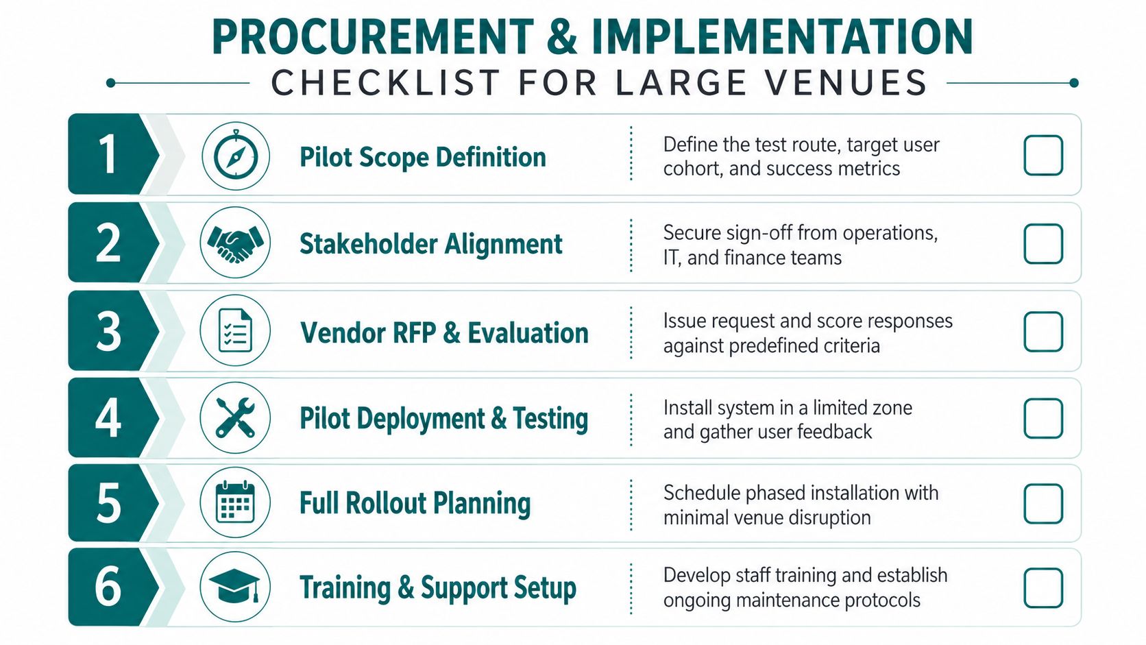
4. Test in a limited zone
Run the system during normal operations and busy periods. Test wrong turns, blocked corridors, poor lighting, lifts, stairs, toilets, ticket barriers, and handover points between outdoor and indoor routes. Record staff interventions, route corrections, complaints, and completion behaviour.
5. Protect data and map assets
Movement data can reveal sensitive patterns. Establish retention, access, residency, and deletion rules, and assess GDPR and PIPL obligations where they apply. Treat floor plans as sensitive operational information. Confirm whether the operator owns the map, route graph, analytics, and edits at contract termination.
6. Agree the maintenance model
Beacons need battery replacement and coverage checks. Digital signage needs firmware, screen, media-player, and network support. Apps need release management and user adoption work. Any system needs a route-editing workflow that can publish a closure before visitors reach the blocked decision point.
For venue teams connecting navigation with visitor experience, Purple's guide to fan engagement excellence provides useful context on the wider operational role of digital venue services. Keep the RFP grounded in the P&L: measure staff pressure, avoidable infrastructure spend, accessibility complaints, route completion, and the cost of inaccurate information. Waymap's vendor selection criteria can support that evaluation process.
KPIs and ROI That Survive a Finance Review
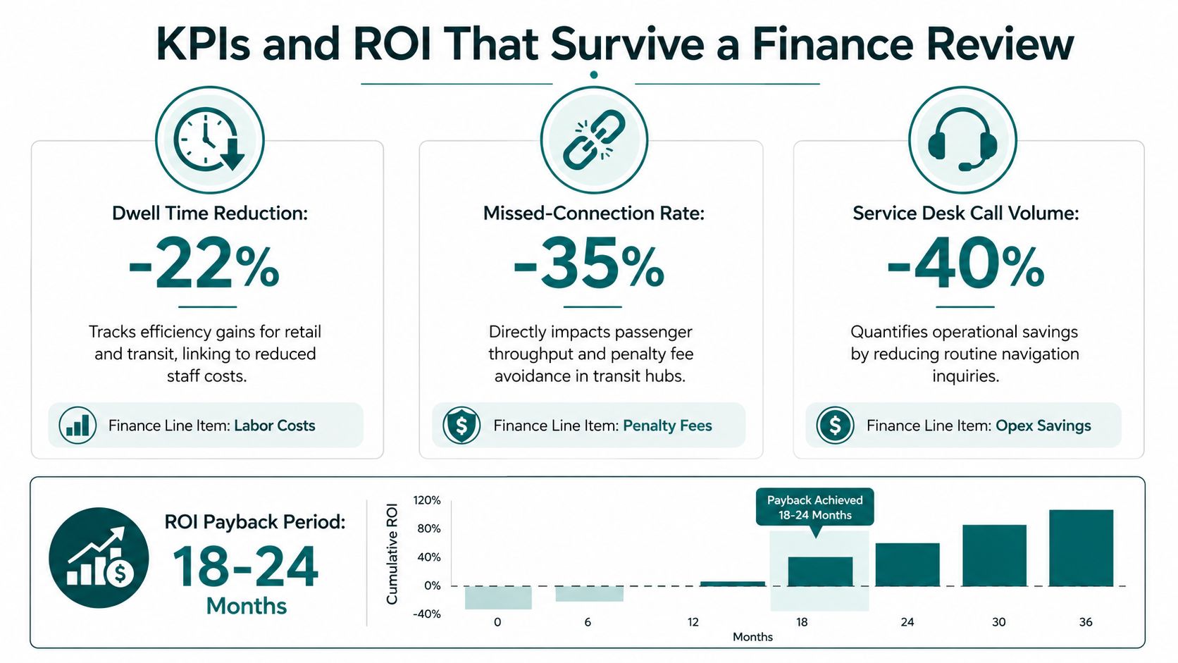
Finance teams don't approve wayfinding because an app looks polished. They approve it when the operator can connect navigation to labour, capacity, capital, service quality, and risk.
For a metro operator, measure the time and intervention associated with inter-modal transfers. If passengers regularly ask staff how to reach a platform or miss a connection because a route is unclear, the relevant evidence is not download volume. It is passenger throughput, assistance demand, and the operational effect of clearer movement.
A hospital should track late arrivals to outpatient appointments, staff time spent giving directions, and repeated calls to reception. Estates teams can compare the cost of correcting route information with the cost of printed signs, temporary boards, and staff redeployment. They should also record whether accessible routes remain usable when lifts, corridors, or entrances change.
In retail and stadiums, information-desk demand and visitor dwell behaviour matter. A clearer route can reduce routine enquiries and help teams focus on service issues that require human attention. The commercial case still needs discipline. Don't claim revenue growth unless the venue can connect navigation behaviour to a verified transaction or operational outcome.
The capital question
Capex avoidance deserves its own line. A navigation approach that doesn't require beacons, new screens, or extensive cabling can shift the project away from a capital works programme and into an operating budget. That changes the approving stakeholder, the procurement timetable, and the financial risk.
The inclusion question
Accessibility complaints, route failures, and staff interventions provide a practical inclusion record. ESG and diversity reporting should reflect whether the venue has made access more usable, not merely whether it purchased compliant equipment. For teams building a wider measurement framework, these business evaluation KPIs from Blu Dragonfly LLC offer a useful prompt to connect operational measures with business decisions.
The strongest business case combines financial and human measures: lower navigation assistance demand, fewer route failures, less infrastructure maintenance, better access information, and a documented process for correcting the map.
What Real Deployments Reveal About Vendor Choice
The useful comparison isn't “digital versus physical”. It is the infrastructure burden each venue is prepared to own.
A metro may pair ceiling-mounted BLE beacons with an app to address confusion during inter-modal transfers. The operator accepts survey work, coverage tuning, and a recurring battery-swap cycle because it owns the station estate and expects the route structure to remain stable.
A hospital may choose computer-vision navigation for an estate it can't cable. That can reduce the need for physical network installation, but it trades cabling for cameras, imagery catalogues, and compute overhead. The procurement lesson is to price the operating model, not just the installation.
A stadium may run a beacon-free dead-reckoning pilot to guide visitors from ingress points to seat blocks. If the pilot avoids on-site positioning infrastructure, it may also avoid a separate capital approval for hardware. The trade-off shifts towards accurate building models, route validation, and a process for changing maps when event layouts change.
| Venue | Solution type | Infrastructure burden | Key lesson |
|---|---|---|---|
| Metro | BLE beacons with mobile navigation | Installed hardware and battery maintenance | Owned, stable estates can justify recurring infrastructure |
| Hospital | Computer vision | Cameras, imagery, and compute | A retrofit can avoid cabling while creating a technical operating burden |
| Stadium | Beacon-free dead reckoning | Smartphone sensors and maintained venue maps | Temporary or changing environments benefit from low installed hardware |
Ask every vendor to explain the failure mode, not only the success path. What happens when a lift closes? How quickly can staff update a destination? Can the route reach an exact door or platform rather than a building entrance? Does the system support hands-free audio and haptic guidance? Turn-by-turn navigation guidance is the relevant capability to test in the actual environment.
If the vendor can't show the maintenance task, the maintenance task hasn't been costed.
The best supplier is the one whose burden matches the venue's appetite for capital works, hardware ownership, map editing, and operational change.
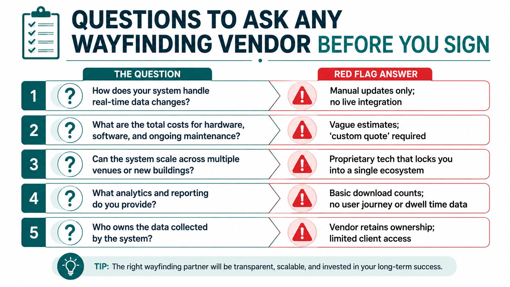
Questions to Ask Any Wayfinding Vendor Before You Sign
Use the following questions as a meeting agenda. Ask for evidence in the response, not assurances in the room.
What infrastructure must we install, power, survey, and replace? Ask who owns hardware after the contract ends and what happens when a screen, beacon, camera, or network component fails. A red flag is a system that describes installation as a one-off task.
What accuracy do you deliver on our real routes? Test underground areas, crowded concourses, steel-reinforced spaces, lifts, stairs, poor lighting, and temporary diversions. A lab demonstration isn't evidence for your building.
How do you support accessibility? Request WCAG 2.2 evidence, local conformance documentation, screen-reader testing, audio and haptic demonstrations, and route testing with disabled users. “The interface is simple” isn't a conformance statement.
Who owns the data and maps? Confirm residency, retention, access controls, export formats, deletion, and the treatment of floor plans after termination. Vendor ownership or limited export rights creates lock-in.
What is the five-year total cost? Include hardware replacement, batteries, licences, integrations, map updates, content work, training, support, and route corrections. “Custom quote” without a cost model is a warning sign.
What does the SLA cover? Require uptime commitments, incident response, map-correction turnaround, closure publishing, and escalation routes. Manual updates only are not enough for a venue where conditions change throughout the day.
The procurement standard is shifting from compliance-led wayfinding to performance-led navigation. Buyers should select the system that reduces avoidable assistance, handles live changes, supports accessible journeys, and fits the venue's financial and maintenance reality. Start with one difficult route, invite operations and access teams into the pilot, and demand a five-year cost and ownership model before approval.
Waymap provides indoor, outdoor, and underground navigation using device-native motion sensors and detailed maps, without GPS, Wi-Fi, or installed hardware. If your venue needs step-by-step guidance through changing, signal-poor spaces, visit Waymap to assess a practical pilot route with your operations and accessibility teams.
