
A Venue Operator's Guide to LiDAR 3D Scanners
If you manage a large public venue, you’re always looking for ways to improve the visitor experience while operating more efficiently. A lidar 3d scanner might sound complex, but it's a practical tool that uses laser light to measure millions of points, creating a highly precise 3D map of your space. This guide explains how it works and why it’s becoming essential for modern public venues.
Why LiDAR 3D Scanners Are Essential for Modern Venues
For anyone running a transport hub, stadium, or large shopping center, the visitor journey is paramount. However, traditional wayfinding based on static signs and paper maps is often confusing in today's complex environments. It can create significant barriers for people with disabilities, especially those who are blind or have low vision.
This is where a lidar 3D scanner can make a significant difference. It does more than just create a better floor plan; it captures a perfect, dimensionally accurate digital twin of your entire venue. This digital copy isn’t just a map. It’s a rich, detailed asset that becomes the foundation for new services.
Building a Foundation for Advanced Services
Once you have this digital twin, it becomes the bedrock for applications that benefit both your visitors and your operations team. The level of precision is vital for:
- Meaningful Accessibility: It provides the granular spatial data needed for advanced navigation aids. For example, Waymap's audio guidance is so accurate it can guide a person with vision loss step-by-step, providing true independence.
- Smarter Operations: This data helps you manage your space better, track assets, and plan maintenance more effectively.
- Improved Visitor Flow: You can analyze how people move through your venue, identify bottlenecks, and enhance safety, especially during busy periods.
This technology represents a fundamental shift. In the UK alone, the LiDAR market is expected to reach USD 830.05 million by 2035, growing at 18.7% annually. Public transport agencies are already using this technology to map complex underground networks, reducing surveying time by as much as 70% compared to traditional methods. You can read more about these market trends and see how they're reshaping infrastructure.
A lidar-derived map is a permanent digital asset for your venue. It moves beyond static signage, creating a dynamic foundation for services that can be updated instantly, improve inclusion, and deliver a superior experience for every visitor.
By investing in a high-quality 3D scan, you are future-proofing your venue. You create a single source of truth that can power everything from facilities management to the kind of inclusive, hardware-free navigation solutions that people increasingly expect. It’s the first, most crucial step toward building a smarter, more accessible, and people-first environment.
How a LiDAR Scanner Builds a Digital Twin of Your Venue
To appreciate what a lidar 3d scanner can do for your venue, it helps to understand the technology. A simple analogy is a bat using echolocation. But instead of sound waves, the scanner sends out rapid, invisible pulses of laser light.
Every second, the scanner fires millions of these laser pulses. They travel outwards in all directions, bouncing off every surface—walls, floors, staircases, and even small fixtures—before returning to the scanner’s sensor.
The key is how the scanner precisely measures the time it takes for each pulse to make that round trip. Because the speed of light is a constant, it can use this timing to calculate the exact distance to every point it hits. This core principle is called Time-of-Flight (ToF).
From Pulses of Light to a Point Cloud
The scanner captures millions, sometimes billions, of measurement points. The result is an enormous and highly detailed collection of individual points, known as a point cloud.
Think of it this way: each point in that cloud has its own exact X, Y, and Z coordinate in 3D space. When viewed together, those millions of points create a dimensionally perfect 3D model of your venue, showing its complete structure and contents with incredible clarity.
This isn't just a basic floor plan. A point cloud can be a 'digital twin' so accurate it captures details down to the millimeter. Three main components work together to make this happen:
- The Laser: Emits the focused pulses of light.
- The Mirror: A rapidly rotating mirror directs the laser pulses across the entire environment, ensuring full coverage.
- The Receiver: A highly sensitive sensor detects the light pulses as they bounce back and records their travel time.
This diagram shows how LiDAR scanner data capture is the first step toward creating a digital twin, which ultimately helps provide a better experience for visitors.
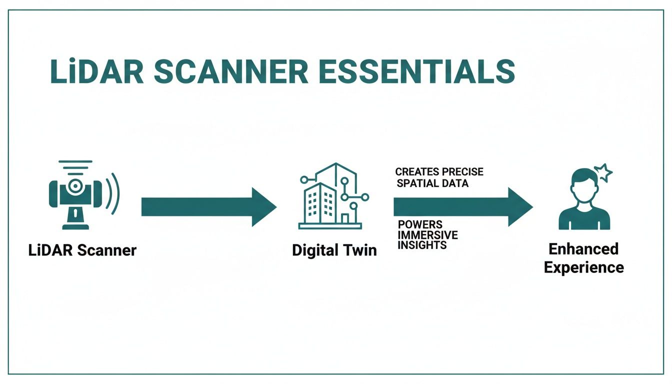
As you can see, the scanner is the starting point for creating a valuable digital asset, which is then used to deliver real-world benefits for people moving through the space.
Creating a Permanent Digital Asset
This digital twin becomes a permanent, foundational asset for your venue. It’s far more than a snapshot in time; it's a rich spatial database you can use for years to come. If you want to dive deeper into the technical details, feel free to explore our guide on what a LiDAR scanner is and its functions.
A highly accurate 3D model like this captures everything, from major architectural features like columns and mezzanines, down to smaller fixed objects like information desks, bins, and ticket barriers. This is the essential raw material for everything from asset management and operational planning to, most importantly, creating truly inclusive navigation systems that work for everyone.
Choosing the Right LiDAR Scanner for Your Venue
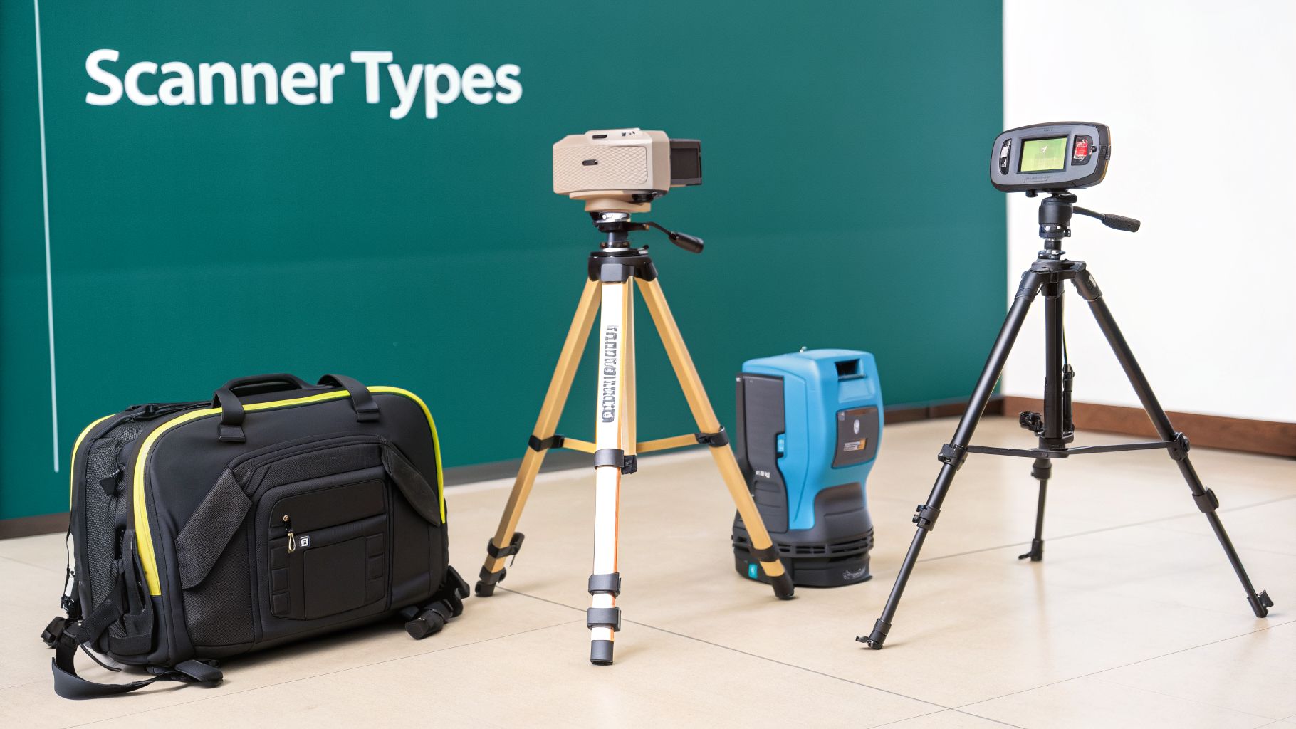
Picking the right lidar 3d scanner for your venue isn't just a technical choice—it's a decision that will shape the quality and usefulness of your digital map for years to come. Not all LiDAR systems are created equal, and understanding the differences is key to getting a survey that meets your needs.
The best choice always comes down to a balance of speed, accuracy, and budget. Whether you're capturing the intricate details of a historic train station or mapping a sprawling modern airport, there’s a LiDAR solution right for the job.
Terrestrial LiDAR Scanners for Pinpoint Accuracy
When you cannot compromise on accuracy, static scanners—also known as Terrestrial LiDAR Scanners—are the industry standard. Mounted on a tripod, they remain perfectly still during a scan, capturing incredibly dense and precise point clouds of their surroundings. You can think of them as high-resolution panoramic photographers, but instead of taking a picture, they're taking millions of 3D measurements.
This level of detail makes them perfect for:
- Architecturally Complex Venues: Think historic buildings, ornate museums, or grand transit hubs. Their millimeter-level precision captures every detail.
- Engineering-Grade Projects: If your 3D model will be used for construction, renovation, or structural analysis, this level of accuracy is required.
- Creating a Foundational Map: They create the most reliable "single source of truth" for a venue. This is vital for building the base map that underpins accessibility platforms like Waymap.
The main trade-off is speed. The process involves methodically moving the tripod from one spot to the next to get full coverage, which can take time in a very large space.
Mobile and Handheld LiDAR for Speed and Flexibility
For vast spaces like airport terminals, shopping centers, or university campuses, speed is often a top priority. This is where mobile and handheld LiDAR scanners excel. These systems are usually mounted on a backpack or a cart, or simply carried by an operator, allowing them to scan continuously while walking through the venue.
This method uses a technology called Simultaneous Localization and Mapping (SLAM), which builds the map in real-time as the scanner moves. The technology has grown in popularity, particularly after a major US tech firm acquired UK-based GeoSLAM, a pioneer in the field.
Today, metro operators use these devices to create as-built scans of busy stations with 99.9% accuracy, even in cluttered environments. It's no surprise that short-range scanners now command a 60% market share for indoor mapping. You can read more about these 3D laser scanner market dynamics to see how the industry is evolving.
Aerial and Smartphone LiDAR for Niche Jobs
Two other types of LiDAR are worth knowing about, though they tend to be used for more specific tasks.
Aerial LiDAR involves mounting a scanner on a drone. To better understand how a scanner creates a digital twin, it’s worth exploring different data capture methods, including the details of modern aerial drone mapping, comparing photogrammetry vs LiDAR. This approach is excellent for capturing large outdoor areas—think university campuses, sprawling hospital grounds, or the entire exterior of a stadium.
On the other end of the scale, many smartphones now have their own tiny LiDAR sensors. While they aren't accurate enough on their own to create a venue-wide map for precision navigation, they're useful for small, targeted updates or as part of a sensor-fusion system like Waymap’s. In that context, they help to orient a user within a pre-existing, professionally scanned map.
Comparing LiDAR 3D Scanner Types for Venue Mapping
To make the choice clearer, here is a simple table comparing the main scanner types. This should help you weigh the pros and cons for your specific venue.
| Scanner Type | Best Use Case | Typical Accuracy | Relative Speed | Relative Cost |
|---|---|---|---|---|
| Terrestrial | Intricate architecture, engineering projects | Millimeter-level | Slower | High |
| Mobile/Handheld | Large, open venues (airports, malls) | Centimeter-level | Very Fast | Medium-High |
| Aerial (Drone) | Large outdoor campuses, building exteriors | Centimeter-level | Fast | Medium-High |
| Smartphone | Small updates, user positioning | Meter-level | Instant | Low |
Ultimately, the best lidar 3d scanner for your venue is the one that fits your budget and timeline, but most importantly, delivers the quality of data you need to truly serve your visitors.
The Data Workflow from Raw Scan to Usable Map
A lidar 3d scanner produces a highly accurate point cloud, which is an excellent raw ingredient. But it’s not the final product. To get real value from that dense cloud of millions of data points, it must be processed and refined. This is where raw geometry is turned into the clean, intelligent map needed for advanced applications.
Once the scan is complete, the work has just begun. The quality of these next steps in collecting and analyzing data is what ultimately determines how useful your final digital map will be.
Registration: Stitching the Scans Together
First is a crucial step called registration. Unless you’re mapping a tiny room, you’ll need to scan a venue from multiple positions to capture every angle and avoid 'shadows' where surfaces are blocked. Registration is the process of digitally stitching these individual scans together into a single, cohesive 3D model.
Think of it like assembling a high-tech jigsaw puzzle. Each scan is a piece, and sophisticated software finds common reference points between them to lock everything into place. When done correctly, the result is a seamless point cloud covering the entire venue, with no gaps or misalignments.
Classification and Feature Extraction
With a complete point cloud stitched together, the next phase is classification. This is where software, often assisted by artificial intelligence, identifies and categorizes the different elements within the 3D model. It’s how we add a layer of intelligence to the raw geometry.
The software learns to distinguish between:
- Horizontal surfaces like floors and ceilings.
- Vertical surfaces like walls and columns.
- Navigational features such as stairs, escalators, and lifts.
- Architectural details including doors, windows, and ticket barriers.
This step transforms a simple 3D model into a structured, understandable dataset. Instead of just a collection of points, you now have a map that understands what its different components actually are.
This intelligent classification is fundamental. It’s what allows a navigation platform like Waymap to understand that a user is approaching a staircase and needs specific instructions, rather than just seeing an undifferentiated cluster of data points.
From Point Cloud to a Navigable Map
Finally, the classified data is polished into clean, usable formats. This usually means converting the complex 3D point cloud into simplified 2D floor plans and optimized 3D models. All the noise and unnecessary data—like people who walked through the scan or temporary objects—is stripped away, leaving only the permanent architectural features. If you're interested in the details of this stage, our guide to floor mapping software goes into much more detail.
This refined map is the feature-rich foundation that powers advanced services. The growth in UK 3D Laser Scanning Services is being driven by this efficiency, with some projects seeing time cut by up to 70% compared to manual methods. For transport agencies, these services can digitize 95% of a rail network. This is the vital stage where raw data becomes the powerful tool that enables precise, step-by-step audio navigation.
From a Digital Twin to a Live Service
So you’ve gone through the process, hired professionals, and now you have a highly accurate 3D map of your venue, created with a lidar 3d scanner. What happens next? This digital twin is far more than a fancy floor plan. It’s the foundation for making your venue smarter, more accessible, and friendlier for every visitor.
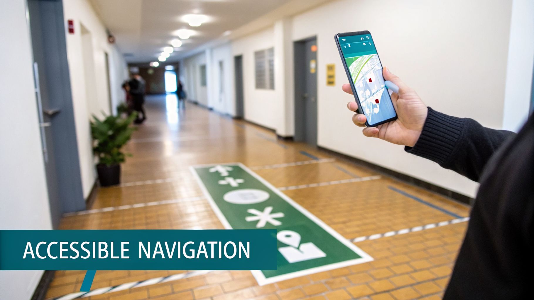
The real power comes when you see it as a dynamic operational tool. For years, venues have relied on physical signs, which are not only expensive to update but often ineffective for many visitors, particularly people with disabilities. Your LiDAR map is the key to moving beyond that outdated model.
When this digital foundation is connected to a platform like Waymap, it brings a whole ecosystem of services to life. You can offer step-accurate audio navigation for your visitors with vision loss or provide clear, multilingual guidance for international guests. All of this is possible without installing a single beacon or running extra wires.
Beyond Accessibility, Towards Better Operations
Having a precise digital map is a huge step towards meeting, and even exceeding, accessibility laws like the Equality Act 2010 in the UK. By providing dependable, detailed navigation for people with disabilities, you’re not just complying with regulations; you’re building a genuinely inclusive space where everyone can navigate independently.
But the benefits don't stop there. This approach also has a direct, positive impact on your budget and daily operations.
- Reduce Maintenance Costs: Physical signs are expensive to design, print, install, and change. A digital map can be updated instantly, eliminating those recurring expenses.
- Smooth Visitor Flow: By understanding how people actually move through your building, you can spot bottlenecks and make small changes that improve safety and keep everyone moving.
- Create a Better Visitor Experience: When you give people clear, accurate, and personalized directions, you reduce their stress and confusion. That makes for a much better, more memorable visit for everyone.
Your LiDAR map isn’t a file you create once and forget about. It's a living asset. It gives you the power to instantly update routes, add new points of interest, or reroute crowds during an emergency, all from a central dashboard.
Bringing Your Map to Life as a Service
The remarkable precision of a map created with a lidar 3d scanner underpins these advanced services. Think about it: when a shop moves or a departure platform changes, you no longer have to order new signs and schedule disruptive installation work. With a few clicks in your digital map, the correct information is instantly pushed out to every user.
This ability to adapt on the fly is central to managing a modern venue. As we explain in our deep dive on indoor positioning systems, the accuracy of the base map is everything—it directly dictates how reliable the navigation experience will be.
Ultimately, commissioning a LiDAR scan is the first, most important step in building a more intelligent, responsive, and human-focused venue. It’s the essential framework for a system that not only guides people but also gives you the data you need to manage your space more effectively. It’s how you turn a one-off project into a lasting operational advantage.
Common Questions About LiDAR 3D Scanning
If you’re running a venue, it’s natural to have questions before adopting new technology. A LiDAR survey is a significant step, and you need to understand the costs, time commitment, and long-term value it will bring. Let’s address some common concerns.
How Much Does a LiDAR Scan Cost?
There's no single price tag. The cost depends on the size of your venue, its architectural complexity, and the level of detail required. Scanning a small, open-plan shop might cost a few thousand dollars, while a large, multi-level transport hub will be a more substantial investment.
It's helpful to view this as a capital investment. You’re not just paying for a service; you’re creating a permanent digital asset for your building. A good quote will cover both the on-site scanning and the crucial data processing work that turns raw points into a clean, usable map. The return on investment comes from smarter operations, lower long-term maintenance costs, and a vastly better experience for your visitors.
How Long Does It Take, and Will It Disrupt My Operations?
Modern LiDAR scanning is surprisingly fast. A medium-sized space, like a museum or a local library, can often be fully scanned within a single day. For much larger and more complex sites—such as an airport terminal or an entire university campus—it might take a few days to get complete coverage.
The real advantage is how little it disrupts daily activities. We can schedule the work during quiet periods, or even overnight, to ensure your visitors and staff aren't disturbed. Compared to traditional surveying methods that could take weeks and cause major disruption, a lidar 3d scanner survey is far more efficient.
This speed minimizes your downtime and provides a complete digital twin of your space without interrupting business as usual—a crucial factor for any busy public venue.
What If My Venue’s Layout Changes After the Scan?
This is where having a digital map truly shows its strength. Static signs are a headache to change, but a digital map is built to be flexible.
For small changes, like moving a customer service desk, the map can be updated easily without rescanning the whole building. If you’re planning something bigger, like a new wing or a complete floor reconfiguration, we would just perform a targeted scan of the new areas. That new data is then stitched seamlessly into the existing 3D model, so your map always reflects reality.
This adaptability ensures that any wayfinding information, especially for a system like Waymap, stays perfectly accurate and reliable as your venue evolves.
At Waymap, we help you turn that precise digital map into a powerful service for every visitor. Discover how our hardware-free navigation can make your venue more accessible and efficient.