
Does an Augmented Reality Map Solve Your Wayfinding Problem?
Imagine a passenger trying to find their departure gate in a sprawling airport, or a first-time patient navigating a complex hospital campus. Instead of squinting at confusing signs, they hold up their phone. On the screen, digital arrows and destination names appear, layered directly over the real world.
This is the promise of an augmented reality map. But as a facilities director or operations lead, your question isn't whether the technology is interesting, but whether it solves a real operational problem, reliably and cost-effectively.
What is an augmented reality map, and what problem does it solve?
An augmented reality map is a digital wayfinding tool that uses a device's camera and sensors to overlay navigational cues onto a live view of the physical world. Unlike a traditional 2D map which provides a top-down, abstract view, an AR map offers real-time, in-context visual instructions.
For anyone managing a large and complex public venue, the core problem it aims to solve is visitor disorientation. This single issue has significant operational consequences: it leads to missed appointments, frustrated customers, and staff being constantly interrupted to provide directions. An effective AR map system can mitigate these issues by helping people move through a space with greater confidence and efficiency.
How big is the AR market?
The adoption of AR for wayfinding is growing. The global mobile augmented reality market was valued at $13.3 billion USD in 2024 and is projected to reach $15.2 billion USD in 2026—a compound annual growth rate of approximately 7%.
This growth reflects increasing investment from transport authorities, healthcare trusts, and large retailers who are looking to AR to solve tangible wayfinding challenges. You can review the market projections in more detail via Statista's analysis of the augmented reality market.
What are its core capabilities?
An AR map system has several key functions that distinguish it from static signage or conventional map applications. Understanding these is critical to evaluating its potential impact on your operations.
Real-Time Visual Guidance: The system provides directions within the user's direct line of sight. This reduces the cognitive load of translating a 2D map to a 3D environment, making instructions immediate and simple to follow.
Contextual Information Display: The map can present timely, location-specific information. This could include gate changes at an airport, special offers in a retail centre, or detailed information about an exhibit in a museum.
Dynamic and Centralised Updates: Unlike physical signage, which is costly and slow to change, an AR map's content is managed centrally. A closed corridor, a temporary diversion, or a new retail unit can be reflected across the system instantly, ensuring information is never out of date.
By integrating these functions, an augmented reality map creates a responsive information layer over a physical space, aiming to create a more efficient and user-friendly environment.
How does AR navigation technology work?
Most AR map systems rely on a combination of a smartphone's built-in sensors and its camera to determine a user's location and orientation.
The phone’s accelerometer and gyroscope track movement, a process known as inertial navigation. The system uses sensor fusion to combine data from these different sensors to build an accurate picture of the user's motion—steps taken, turns made, and changes in elevation.
Many systems supplement this with camera-based computer vision techniques like SLAM (Simultaneous Localisation and Mapping). This allows the phone to "see" its surroundings, identifying unique features like walls, doorways, and fixtures to build a live map and place the user within it.
Why do most hardware-based AR systems fail at scale?
While camera-based systems can be effective in some scenarios, many AR solutions also depend on an external hardware ecosystem. This typically involves installing hundreds or even thousands of Bluetooth beacons or specialised Wi-Fi access points throughout a venue to broadcast location signals.
For operations and facilities directors, this hardware-first approach presents significant and predictable operational challenges:
- High Installation Costs: The capital expenditure for procuring and installing thousands of beacons across a large transport hub or hospital is substantial.
- High Maintenance Overhead: Batteries require replacement. Units fail. This creates a perpetual maintenance cycle of diagnosing, locating, and servicing devices, driving up the Total Cost of Ownership (TCO).
- Signal Unreliability: In crowded areas or environments with significant concrete and steel, RF signals from beacons can become patchy, leading to an inconsistent and unreliable user experience.
An effective wayfinding system must be reliable. The limitations of hardware-dependent architectures often become most apparent in the exact complex environments they are meant to serve.

As the comparison shows, traditional maps place the burden of interpretation on the user. AR maps aim to remove this ambiguity, which is particularly valuable when navigating a complex indoor space.
Is an infrastructure-free alternative viable?
An infrastructure-free navigation system, such as Waymap, eliminates the need for external hardware entirely. It operates purely on the smartphone’s internal motion sensors, correlating that movement data against a hyper-accurate, pre-built digital map of the venue. No beacons, no Wi-Fi triangulation, and no camera is required for the core navigation to function.
This architecture fundamentally changes the operational calculus. By removing dependence on physical hardware within the venue, it simplifies deployment and drastically reduces long-term maintenance costs, offering a genuinely scalable and cost-effective solution.
Because the system requires only sensor data and the pre-loaded map, its reliability is exceptionally high—even in areas with no network signal, such as deep within an underground transport system. For a facilities director, this means a predictable, low-maintenance system that performs consistently.
We explore these different architectures in our guide to indoor positioning systems. For any organisation focused on operational efficiency and a low TCO, the business case for an infrastructure-free approach is compelling.
Is an AR map an engagement tool or a navigational utility?
It is a mistake to view an augmented reality map solely as a tool for getting people from A to B. To do so is to miss its primary strategic value.
Viewing AR as just a navigational cost to be managed overlooks its power to transform a physical space into a deeply interactive environment. This capability unlocks new opportunities for visitor engagement and revenue generation.
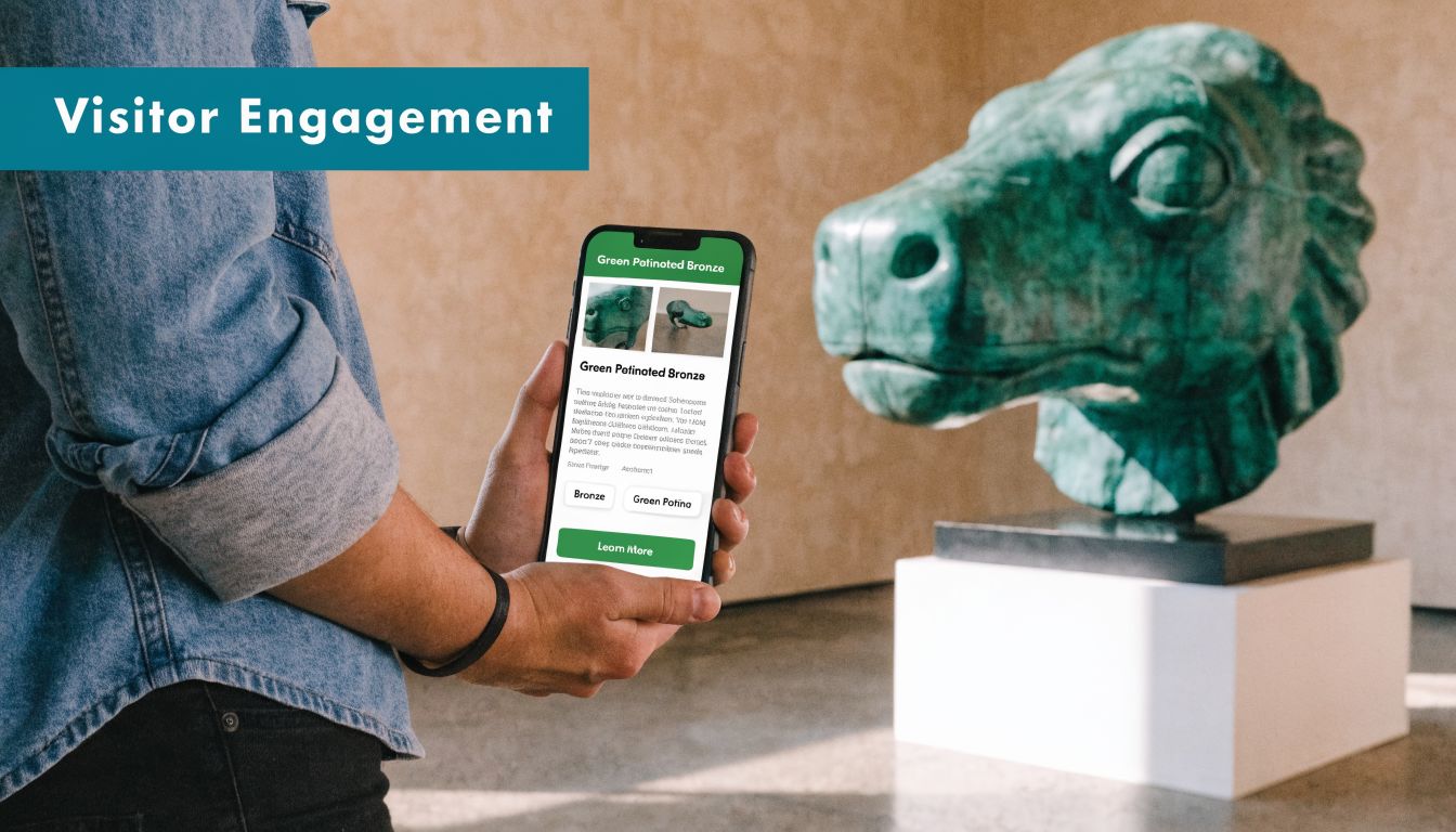
Consider a visitor in a museum pointing their phone at a sculpture and seeing its history unfold in an overlay. A fan at a sports stadium gets live player stats overlaid on the pitch from their seat. A shopper receives a timely, personalised offer as they walk past a specific store. The map ceases to be a simple utility and becomes a strategic asset for communication and commerce.
How can you turn spaces into experiences?
By layering relevant, contextual information onto the physical world, you are not just guiding visitors—you are enriching their journey. This directly impacts satisfaction and can unlock new revenue streams. The map becomes a dynamic platform for communication and commerce.
This is not a theoretical concept. Google Maps' AR features demonstrate how AR can combine navigation with storytelling, for example by overlaying historical photos onto a present-day street view.
The principle is the same for any large venue, from an airport to a university campus. The key is to see the augmented reality map not as a single-purpose tool, but as a platform upon which countless other experiences can be built.
This shift in perspective is crucial. An AR map isn't just about reducing friction in wayfinding; it's about adding layers of value that make a visit more memorable, informative, and engaging.
What is the business case for engagement?
The business case becomes clear when these engagement features are tied to specific operational goals. A stadium can work with sponsors to deliver branded AR content. A university can create immersive, self-guided campus tours for prospective students, freeing up staff time. The map itself becomes a two-way communication channel.
Explore other innovative display methods with The Print Warehouse display insights.
For a transport operator, this could mean displaying live departure times and platform changes directly through a passenger's camera view. For a hospital, it might involve offering multilingual information and directions. Each application moves the AR map beyond basic utility and into the realm of strategic advantage.
How can you create a genuinely accessible environment?
True accessibility is not about legal compliance. It is about creating environments where every person can navigate with independence and dignity. While AR maps can play a role, not all AR technology is inclusive.
Many systems are built around visual overlays—arrows and icons displayed on a phone screen. While visually impressive, this approach inherently excludes anyone who is blind or has low vision. It is a fundamental failure of inclusive design, creating a digital barrier where technology should be building a bridge.

Why is an audio-first approach more inclusive?
A truly inclusive navigation system must prioritise senses other than sight. An audio-first design provides precise, step-by-step audio instructions, enabling hands-free, heads-up navigation. This is not an add-on feature; it is a fundamentally different and more inclusive design philosophy.
This is the principle upon which Waymap was founded. Working directly with and for visually impaired users, we developed a system that uses only a phone's built-in motion sensors to learn a user's unique movements, delivering directions with step-accurate precision.
By prioritising auditory cues, this approach makes complex environments fully navigable for people with sight loss. This not only meets accessibility mandates but also powerfully demonstrates an organisation's commitment to its Environmental, Social, and Governance (ESG) principles.
What is the operational advantage of inclusive design?
Selecting an inclusive navigation solution is a strategically sound operational decision. A system designed to work in the most challenging use cases—for example, for a user with no vision—proves to be exceptionally robust for all users.
An audio-first AR map delivers universal benefits:
- Hands-Free Navigation: It benefits anyone with their hands full, from commuters with luggage to parents with pushchairs.
- Reduced Cognitive Load: Following simple audio instructions is often less distracting than interpreting a visual map, creating a calmer experience.
- Infrastructure-Free Reliability: Because our system does not rely on cameras or beacons, it functions reliably underground, in crowds, and in all lighting conditions.
Creating a genuinely accessible environment requires looking beyond the visual gimmicks of AR. The key is to deploy a solution that provides genuine independence to every user. This begins with the quality of the underlying map, which is why we build hyper-accurate 3-D site models. A system that works for a blind user in an unfamiliar, busy train station will work brilliantly for every passenger.
What are the practical realities of deploying an AR map?
For any operations lead or facilities director, technology decisions come down to practicality, cost, and maintenance. It is essential to look beyond the sales pitch and understand the long-term operational commitment of an AR map system.
Many early-generation AR systems rely on a network of physical hardware like Bluetooth beacons. While functional, this approach comes with significant operational burdens. The initial capital cost of purchasing and installing thousands of units across a large site is often prohibitive.
This initial outlay is just the beginning. The devices require ongoing maintenance. Batteries fail. Units break. This creates a perpetual cycle of fault-finding and replacement, which quietly consumes time and budget, driving the Total Cost of Ownership (TCO) ever higher.
How can you minimise the operational burden?
An infrastructure-free solution like Waymap inverts this model. By operating exclusively on a smartphone's sensors and a hyper-accurate digital map, it eliminates the need for any physical hardware to be installed or maintained in your venue.
The business case is therefore straightforward:
- Dramatically Lower TCO: With no hardware to procure, install, or service, the lifetime cost of the system is significantly reduced.
- Instant Software-Based Updates: If a route is closed or a new retail unit opens, the change is made in the map data. The update is pushed to all users instantly, with no site visit required.
- Simplified, Low-Disruption Deployment: Implementation is faster and less disruptive. The process focuses on creating a precise digital twin of your space, not managing a large-scale hardware installation. Find out how we use 3-D LiDAR scanning to create these maps.
By removing the reliance on physical infrastructure, the operational burden shifts from constant hardware management to simple software updates. This allows your team to focus on core responsibilities, not endless maintenance tasks.
In complex environments, digital wayfinding often complements other systems. For facilities needing to track physical assets, for example, it can be useful to manage inventory with QR codes.
Furthermore, data privacy is a critical consideration. A system that does not require persistent camera access for navigation inherently offers a more private experience for users, mitigating a significant data governance risk. For any decision-maker, the optimal AR map is one that delivers maximum value with minimum operational overhead.
Frequently Asked Questions About Augmented Reality Maps
As a decision-maker considering AR wayfinding, you will have practical questions about cost, deployment, and security. Here are direct answers to the most common queries.
How much does an augmented reality map cost?
The cost of an augmented reality map is determined by the underlying technology. A system dependent on physical hardware like Bluetooth beacons requires significant upfront capital investment for the devices and their installation, plus ongoing operational costs for maintenance and battery replacement. An infrastructure-free solution like Waymap eliminates these hardware costs, dramatically lowering the Total Cost of Ownership (TCO). The investment shifts to the one-time creation of a hyper-accurate digital map of your venue and a predictable software subscription, which is a more scalable and cost-effective model.
How long does it take to deploy an AR map?
Deployment time is directly linked to the system's architecture. A hardware-based deployment can take months for a large site, involving site surveys, installation logistics, and testing. An infrastructure-free system is significantly faster to deploy. The primary task is the digital mapping of the site, which specialist teams can complete efficiently with minimal disruption to your operations. Once this digital twin is created, the system can be activated almost instantly.
Are AR maps secure and do they respect user privacy?
This is a critical security and data governance question. Some AR solutions require constant camera access to function, which creates significant privacy risks for users and data management challenges for your organisation. A system like Waymap, however, is designed for privacy. It does not require camera access for navigation, relying instead on the phone's internal motion sensors. No images or videos of your venue or its occupants are ever captured, processed, or stored for navigation, providing a fundamentally more secure and private experience.
Can AR maps be used for more than just navigation?
Yes. While wayfinding is the core function, a well-designed AR map serves as a platform for visitor engagement. This is particularly evident in the cultural and heritage sector, where AR is used to create immersive experiences. For example, visitors can see historical sites as they once stood or access multilingual information about artefacts. You can read more about AR's role in historical restoration to see examples. In your venue, this could mean displaying tenant promotions, providing information about points of interest, or sharing live event updates.
What is the difference between AR, VR, and MR?
These terms are often confused. Here is a simple distinction:
- Augmented Reality (AR) overlays digital information onto your view of the real world. You remain present in your physical environment.
- Virtual Reality (VR) completely replaces your real-world environment with a simulated digital one, typically via a headset that blocks out your surroundings.
- Mixed Reality (MR) is an advanced form of AR where digital objects are not just overlaid but can also interact with the real world in a spatially aware context.
For public wayfinding, AR is the relevant technology as its purpose is to enhance a person's perception of their immediate physical surroundings to improve navigation.
Ready to make your venue truly navigable for everyone? With Waymap, you can deploy a precision navigation system that enhances accessibility, improves visitor flow, and lowers operational costs—all without installing a single piece of hardware. Learn more at https://www.waymapnav.com.