
10 Wayfinding Examples That Make Access Work
A passenger is changing platforms, a family is trying to find a hospital clinic, or a fan is searching for the right entrance before a match starts. In each case, a missed turn creates more than inconvenience. It can mean a late arrival, another request for staff assistance, or an inaccessible route that leaves someone unable to continue independently.
The strongest wayfinding examples treat navigation as an operational service, not a collection of attractive signs. They connect exact destination guidance with inclusive access, accurate venue data, changing routes, and measurable outcomes. London's Legible London programme demonstrates how coordinated pedestrian information can influence behaviour and reduce disorientation at city scale, with reported evaluation figures including a 5% increase in walking, a 60% decrease in people feeling lost, a 16% improvement in pedestrian journey time, and a 66% increase in knowledge of local-area context (Applied Information's Legible London project summary).
The ten examples below cover transit, healthcare, retail, campuses, stadiums, airports, offices, libraries, and public-sector accessibility. Each one focuses on the practical question venue leaders need to answer: what problem was solved, what operational choice made it possible, and what can another organisation replicate?
1. Washington Metropolitan Transit Authority uses infrastructure-free navigation
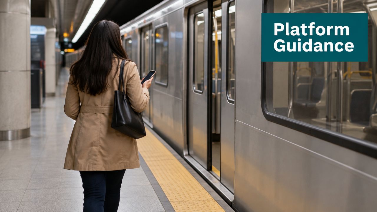
The Washington Metropolitan Area Transit Authority, or WMATA, illustrates why digital wayfinding needs to work where GPS and installed hardware don't. Its Metro system spans 97 stations and serves 91 million annual riders, according to the deployment brief for Waymap's work with the network. In a system with underground platforms, complex interchanges, escalator closures, and changing passenger flows, physical signage alone can't provide a complete route to an exact platform entrance or train door.
Waymap uses the smartphone's native motion sensors, detailed station maps, and sensor fusion to provide step-accurate guidance without GPS, Wi-Fi, or beacon hardware. That choice addresses a familiar transport-operator constraint. A physical sign network is expensive to alter when a route changes, while a digital map can be amended by the responsible operations team.
Passengers report greater confidence when navigating complex underground transfers, while operations teams can push route updates in minutes rather than waiting for a physical signage programme. The deployment is described in the Waymap WMATA Washington Metro case study.
Practical rule: Map the difficult interchange first. A simple station won't reveal whether the route model handles level changes, platform access, closures, or the final approach to the train.
What transport operators can replicate
- Assign one data owner: Give a named team responsibility for station maps, points of interest, closures, and accessibility information.
- Prioritise complex stations: Start with major interchanges and multi-level platforms where staff assistance and missed turns are most likely.
- Build adoption into accessibility outreach: Promote the service through accessibility networks, commuter forums, and existing passenger communications.
- Use existing governance: Add map updates to operational workflows rather than creating a disconnected digital silo.
2. Royal Hospital for Children and Young People guides families across a healthcare campus
A hospital journey rarely begins at a department door. Families may need to move from a drop-off point to reception, then to a waiting area, diagnostic service, clinic, or pharmacy. Older NHS facilities have measurable wayfinding problems. A UK hospital study using mobile eye-tracking examined patient journeys, late arrivals, staff time spent giving directions, and observed navigation errors as operational measures for prioritising signage and layout improvements (the NHS hospital wayfinding study).
The Royal Hospital for Children and Young People, an NHS setting in South London, used Waymap to guide patients, families, and staff across a complex campus without modifying hospital premises. That matters to estates teams working around clinical operations and constrained capital budgets. An infrastructure-free deployment avoids beacon installation, Wi-Fi surveys, construction coordination, and disruption to treatment areas.
The Royal Hospital for Children and Young People case study focuses on journeys to wards, outpatient clinics, diagnostic centres, and service points. The practical outcome is a route that supports families arriving for appointments, temporary staff working unfamiliar shifts, and patients who need guidance beyond a building-level label.
Map the journey, not just the department
A hospital map that contains only “paediatrics” or “outpatients” leaves too much work to the visitor. Include waiting areas, specimen collection points, pharmacy locations, entrances, lifts, and accessible alternatives. Reception and nursing teams should know what the service provides, so they can recommend it without becoming the navigation system themselves.
Patient feedback is essential. Families can identify missing waypoints, confusing terminology, or routes that look valid on a plan but fail in practice because a corridor is restricted or a door is difficult to find.
3. Westfield London keeps retail wayfinding current as tenants change
Retail wayfinding has a problem that hospitals and stations share, but with a faster commercial cycle. Shops move, pop-up spaces appear, seasonal experiences occupy common areas, and tenants change their opening details. A printed directory or static map can become misleading soon after it is installed.
Westfield London uses Waymap to provide venue navigation to specific shops and points of interest while allowing centre management to update location data. The operational benefit is not a digital version of a mall directory. Management can amend retailer locations and other points of interest without replacing physical signs or maintaining a beacon network in a signal-poor environment.
The Waymap retail venue overview also frames navigation as a communication channel. A visitor searching for a category can receive relevant information about a retailer or experience, while centre teams can promote new tenants through the same interface. That creates a trade-off. Promotional content must remain subordinate to clear directions. If advertising obscures the route, visitors lose trust in the system.
Make tenant data part of centre operations
- Connect updates to lease processes: Tenant moves, opening changes, and temporary closures should trigger map updates.
- Separate standard and premium listings: A basic listing can support access, while optional promotion can support commercial objectives.
- Review hard-to-find zones: Search and route data can help teams identify areas that visitors struggle to discover.
- Plan seasonal changes early: Events, pop-ups, and temporary installations need their own map and routing review.

4. SBS Transit supports cross-modal journeys without GPS dependency
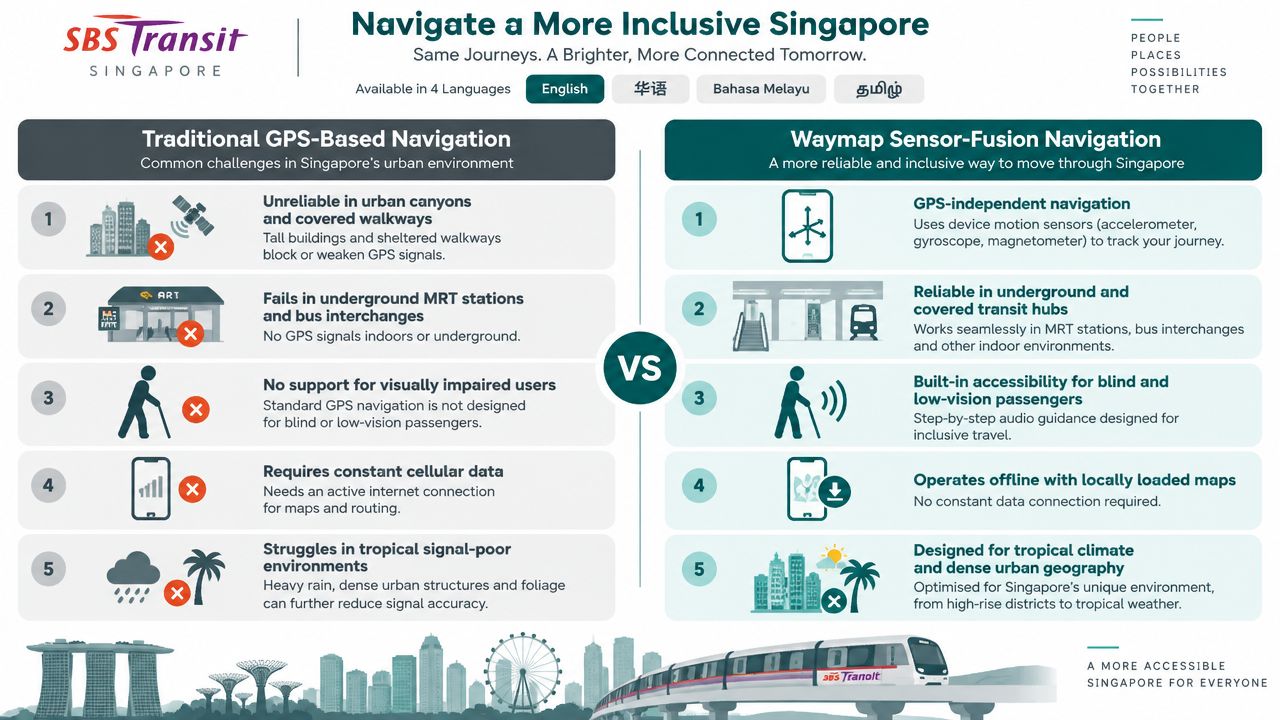
A passenger travelling with SBS Transit in Singapore may need to move from a bus stop to an MRT station, then continue on foot to a local destination. The journey doesn't end when the vehicle arrives. The final route can pass through dense urban streets, covered walkways, interchanges, and areas where GPS positioning is unreliable.
SBS Transit's Waymap deployment addresses that last-mile problem with device-native motion sensors and detailed maps rather than GPS or Wi-Fi coverage. The system provides step-accurate directions across bus stops, stations, and nearby destinations. For first-time passengers and international visitors, that reduces the need to find a customer-service desk during busy periods.
The SBS Transit Singapore case study points to an important implementation choice: integrate live vehicle data at the API level. Static timetables and manual updates won't reflect delays, service changes, or altered interchange conditions quickly enough.
Account for the climate and the street
Singapore's covered walkways and air-conditioned corridors are part of the passenger experience, not incidental details. Mapping should include those pedestrian choices where they form a practical route. A route that is technically short but exposed, inaccessible, or difficult to identify may fail the user's real objective.
Accessibility organisations should participate in testing, particularly blind and low-vision passengers who can identify gaps that screen-led map testing misses. Tourism boards, hotels, and hospitality partners can also help reach visitors before they arrive at an unfamiliar interchange.
5. UK public venues use the Equality Act 2010 as a reason to move beyond static signage
The Equality Act 2010 creates a UK framework for reasonable adjustments for disabled people. For a public venue, accessible wayfinding shouldn't be treated as a sign package added after the building is complete. It needs to support the actual route a person takes, including entrances, changes in level, accessible facilities, and the final destination.
Static signage remains necessary, but it can't provide heads-up, hands-free audio guidance to a blind or low-vision visitor. Waymap was built first for blind and low-vision users and uses audio instructions that don't require a person to read a screen while walking. Its infrastructure-free approach also avoids installing and maintaining Bluetooth beacons or other venue hardware.
The Waymap guide to Equality Act 2010 requirements explains how digital navigation can form part of a venue's documented accessibility provision. It shouldn't replace a full access audit, physical signs, staff support, or emergency procedures. It can add an auditable layer that helps visitors find their way independently and gives managers a clearer record of what has been provided.
UK Inclusive Mobility guidance says routes to station entrances from connecting services, car parks, and drop-off points should work for people with mobility and vision impairments. The same guidance includes practical requirements for route widths and accessible fonts (UK Inclusive Mobility guidance).
Combine digital guidance with physical access
- Test with disabled users: Blind and low-vision participants should test routes before launch and after material changes.
- Document the adjustment: Record the mapped journeys, accessible features, testing feedback, and update process.
- Train frontline teams: Reception, security, and visitor services staff need clear guidance on when to recommend the app.
- Keep static provisions: Digital navigation is an additional layer, not a substitute for compliant signage and emergency information.
For comparison, the US ADA compliant signage guide offers a separate accessibility reference for American facilities. UK organisations should apply the legal and design framework relevant to their jurisdiction.
6. University campuses reduce first-term navigation anxiety with exact destinations
A campus map can show where a building is. It doesn't necessarily tell a new student which entrance to use, how to reach a lecture room, or what to do when construction moves a service. That distinction matters during induction, especially for international students, disabled students, and anyone arriving without an established mental map of the site.
Leading universities use digital wayfinding to guide students from accommodation to lecture halls, libraries, student services, accessible toilets, quiet spaces, and support facilities. The digital layer is useful because campus facilities teams can update temporary routes and relocated offices without reprinting large quantities of maps. A route can point to an exact room rather than stopping at a generic building label.
The most effective launch happens before a student needs help. Add links to welcome emails, learning platforms, induction materials, and accommodation communications. QR codes at entrances and demonstrations at student-union events can help students understand the service before the first high-pressure journey.
Let students improve the map
A student ambassador programme can expose problems that a facilities plan won't show. International students can identify unclear terminology and assumptions about local navigation. Disabled students can test whether the mapped route reflects the accessible route in practice, not merely the shortest route on a plan.
Map lecture halls and student services before lower-priority points of interest. Then use searches, support tickets, and direct feedback to decide where the next mapping effort belongs. The result should be a maintained campus service, not a launch-week app that becomes inaccurate after construction or departmental changes.
7. Stadiums need event-specific routing, not permanent arrows
A supporter who knows the stadium may still struggle when a match, concert, or conference changes the normal route. Entrances, seating blocks, hospitality areas, toilets, concessions, medical facilities, and exits can operate differently from one event to the next. Fixed signs cannot respond to sold sections, temporary barriers, or a congested approach.
Stadiums such as Wembley and Allianz Arena represent the scale and complexity of this challenge. A digital wayfinding layer can connect ticket information with a route to the relevant entrance, accessible seating area, facility, or exit. It can also support staff decisions when crowd-density information identifies a congested zone, although venue operators must define carefully how live operational data is validated and communicated.
Accessibility obligations are part of the core service. Under ADA Title III in the US, and equivalent duties in other jurisdictions, venues need to provide usable access rather than merely sell accessible tickets. Routes should be tested by blind and disabled attendees, including the approach from transport links and car parks.
A route that works on a quiet Tuesday may fail completely when the venue opens every gate at once.
Connect wayfinding to the ticket journey
Include a navigation link in ticket confirmations and event reminders, not only on a venue website. The app should receive the event configuration, seating destination, access requirements where appropriate, and any route restrictions. A football match and a concert may require different guidance even when they use the same bowl.
Run a pre-launch accessibility audit and event simulation. Then measure successful arrivals, late arrivals, customer-service enquiries, and feedback by event type. These measures give operations teams a basis for changing gates, staffing, and route information rather than relying on anecdotal complaints.
8. Airport terminals provide multilingual, time-sensitive navigation
Airports combine unfamiliar architecture, international passengers, fixed departure times, security processes, and changing gate information. A traveller may need to move from a terminal entrance to check-in, security, a lounge, a gate, and an accessible facility while carrying luggage and listening for announcements. GPS doesn't provide dependable indoor positioning, and a Wi-Fi-dependent route can fail in areas with weak connectivity.
A Waymap-style deployment provides step-by-step guidance using detailed terminal maps and phone sensors, without requiring airport construction or a beacon network. Multilingual and audio guidance can support passengers who don't read the local language fluently, older passengers, and disabled travellers. The route still needs to connect to live airport systems. Gate changes, closures, security information, and alternative paths should come through governed operational data rather than manual edits made in isolation.
Heathrow, Singapore Changi, and Frankfurt are examples of international airport environments where terminal navigation must serve diverse passengers. Each airport needs its own map model, terminology, accessibility routes, and escalation process.
Design around the passenger's deadline
Place the navigation link in booking confirmations, check-in reminders, and airport accessibility communications. A traveller who discovers the service at the information desk has already reached the point where uncertainty is costly.
Test with elderly passengers, blind and low-vision users, people with mobility impairments, and passengers unfamiliar with the terminal. Review bottleneck zones after launch. Staff enquiries, late boarding, and passenger feedback can reveal where the route needs better instructions or a different accessible alternative.
9. Office buildings make reasonable adjustment practical across changing floors
A corporate office may change faster than its signage. Tenants reconfigure floors, meeting rooms move, reception areas change, and temporary workspaces appear. An employee who needs an accessible route shouldn't have to depend on a colleague meeting them at the entrance each time they visit a new room.
In the UK, the Equality Act 2010 provides the relevant reasonable-adjustment context for disabled employees. In the US, ADA Title I applies to employment accessibility duties. Digital wayfinding can support the employer's documented process by guiding a person from the building entrance to a specific office, meeting room, facility, or accessible alternative without installing new hardware throughout the workplace.
The operational friction is often ownership. A landlord may control the building, a tenant may control its floor, and a facilities provider may manage shared areas. Without a clear data model, every party assumes someone else will update the route.
Treat employee networks as design partners
Launch the service through onboarding materials, accessibility policies, and employee communications. Line managers should know how to recommend it, while disability employee networks can test routes and identify barriers that a facilities walk-through misses.
Track which rooms and facilities people search for most often. That information can point to missing signs, poor room labels, or a need to improve the physical environment. Keep implementation records and user feedback as part of the employer's accessibility documentation. Wayfinding won't solve every workplace access issue, but it can reduce dependence on ad hoc assistance in a building that changes frequently.
10. Public libraries connect visitors with collections, services, and events
Libraries serve people with different ages, languages, mobility needs, sensory abilities, and levels of confidence with digital tools. A historic library may contain multiple levels, non-linear corridors, restricted areas, children's spaces, study rooms, local-history collections, and event rooms. A visitor who can find the library entrance may still struggle to locate the service they came for.
Infrastructure-free navigation can guide patrons to collections, accessible facilities, children's areas, reference desks, language-support services, and digital-literacy classes without modifying a heritage building. It can also link the catalogue to a route. When someone searches for a collection or event, the result can include directions to the relevant room rather than only a title and opening detail.
The public library is also a useful environment for inclusive adoption. Promote navigation at story times, literacy classes, newcomer orientation sessions, and service desks. Staff should understand the system well enough to recommend it while still offering human support when a visitor prefers it.
Start with destinations people value most
- Map children's services first: Parents and carers often need a clear route to story areas, toilets, and activity rooms.
- Connect catalogue results: A found item or event should lead to a precise location.
- Include specialist services: Local studies, reference desks, language support, and digital-literacy spaces deserve clear destination labels.
- Invite feedback at service points: Patrons can identify confusing room names or routes that aren't obvious from the building plan.
10 Wayfinding Case Comparisons
| Solution | Implementation Complexity 🔄 | Resource Requirements ⚡ | Expected Outcomes 📊 | Ideal Use Cases 💡 | Key Advantages ⭐ |
|---|---|---|---|---|---|
| WMATA (Washington Metro) | 🔄 High, sub‑3m dead‑reckoning requires detailed station maps & governance | ⚡ Low capex; moderate mapping, ops coordination, marketing | 📊 Improved rider confidence; instant operational updates; lower maintenance spend | 💡 Large transit networks with frequent layout/service changes | ⭐ Infrastructure‑free accuracy; ADA/Equality Act support; instant updates |
| Royal Hospital for Children & Young People | 🔄 Moderate, clinical pathway mapping and staff briefings needed | ⚡ No construction; mapping effort, change management, staff outreach | 📊 Reduced patient/family anxiety; fewer escorts; improved appointment punctuality | 💡 Multi‑building healthcare campuses, pediatric hospitals | ⭐ Zero clinical disruption; supports NHS accessibility standards |
| Westfield London (Shopping Centre) | 🔄 Moderate, POI workflows, retailer integrations, dedicated content role | ⚡ Low infrastructure; ongoing POI management staff & marketing | 📊 Faster discovery; higher dwell time & conversion; instant tenant updates | 💡 Dynamic retail centers with frequent tenant churn | ⭐ Real‑time tenant updates; revenue opportunities; offline reliability |
| SBS Transit (Singapore) | 🔄 High, block‑level pedestrian mapping & fleet API integration required | ⚡ Low capex; needs fleet data, detailed mapping, promotion | 📊 Reliable GPS‑independent guidance; fewer missed connections; reduced helpdesk load | 💡 Dense urban transit operators with GPS blackout zones | ⭐ Sensor‑fusion GPS‑independent navigation; multilingual accessibility |
| Equality Act 2010 Compliance (UK venues) | 🔄 Moderate, accessibility testing, user research, org change required | ⚡ Low physical cost; needs testing, mapping, ongoing maintenance | 📊 Auditable compliance; fewer complaints; improved disabled visitor experience | 💡 Public venues seeking legal compliance and inclusive access | ⭐ Demonstrates reasonable adjustment; cost‑effective vs static signage |
| University Campus Navigation | 🔄 Moderate, campus‑wide mapping and portal integrations | ⚡ Mapping effort; promotion at orientation; IT links | 📊 Reduced student wayfinding anxiety; fewer support tickets; scalable | 💡 Large universities with international/new student cohorts | ⭐ Replaces printed maps; improves belonging; accessibility‑first |
| Stadium & Event Venues | 🔄 High, real‑time event config, crowd density and ticketing integration | ⚡ Significant IT/data feeds and pre‑event promotion; no hardware | 📊 Reduced late arrivals; improved crowd flow; verified accessibility | 💡 Large stadiums, conferences, multi‑configuration venues | ⭐ Real‑time crowd routing; emergency routing; ADA/Equality Act compliance |
| Airport Terminals | 🔄 High, FIDS/gate integration, time‑aware routing, multilingual audio | ⚡ Requires flight IT integration, detailed mapping and promotion | 📊 Fewer missed flights; improved on‑time boarding; lower info‑desk load | 💡 International airports serving multilingual, time‑sensitive passengers | ⭐ Time‑aware, multilingual guidance; no terminal modifications |
| Office Building Accessibility | 🔄 Moderate, integrate with access control & office management systems | ⚡ Low capex; IT integrations, employee promotion, maintenance | 📊 Reduced onboarding friction; auditable reasonable adjustments; retention gains | 💡 Large corporate offices and multi‑tenant campuses | ⭐ Demonstrable reasonable adjustments; scalable for reconfigurations |
| Public Library Network | 🔄 Moderate, detailed stacks/room mapping and catalog integration | ⚡ Mapping time; outreach (QRs), catalog links, ongoing updates | 📊 Increased program attendance; fewer desk inquiries; improved access | 💡 Heritage libraries and multi‑branch public systems | ⭐ Enhances access without building modification; supports inclusion |
Turn These Wayfinding Examples Into an Action Plan
The best wayfinding examples share a practical pattern. They start with a real journey, not a technology purchase. The journey may run from a station entrance to a platform, from a hospital drop-off point to a clinic, from a ticket confirmation to a stadium seat, or from a library catalogue result to a collection. Each route needs a defined beginning, an exact destination, and a clear arrival condition.
Map destinations precisely. “Hospital” or “campus” isn't enough. People need the clinic, waiting room, lecture hall, pharmacy, platform entrance, accessible toilet, meeting room, or library service desk. Exact mapping also makes operational ownership clearer because each point of interest can have a responsible team and an update process.
Inclusive testing must happen with the people who will use the route. Blind and low-vision users can identify whether audio instructions provide enough context. People with mobility impairments can test ramps, lifts, surfaces, and detours. Older passengers, families, international visitors, and first-time users can expose language and orientation problems that experienced staff no longer notice.
UK standards and legislation provide the inclusion context. The Equality Act 2010 is relevant to reasonable adjustments, while BS EN 17210 addresses accessibility and usability in the built environment. For stations, the Department for Transport's accessibility roadmap describes audits covering features such as step-free access, seating, toilets, ticket machines, and parking bays (DfT's roadmap to an accessible railway). That matters because 23% of disabled people want information about the location and availability of maps and wayfinding, according to the cited UK transport-accessibility evidence in that roadmap. A route that exists but isn't discoverable is not a complete service.
Physical design still sets the foundation. Transport for London's Customer Information Strategy specifies accessible blue backgrounds with white symbols, text, and borders for signs. It also uses a 200 by 200 mm modular tile format for directional signs and recommends a consistent installation height of 1300 mm to the top edge (TfL's Customer Information Strategy). Accessible-design guidance recommends high-contrast, matt-finish signs mounted consistently, wherever possible, between 1.4 m and 1.6 m above floor level. It recommends tactile signs between 1.4 m and 1.7 m, using embossed rather than engraved lettering (Accessible Design Note 04 on wayfinding and signs.
Live data is the operational test. Rail and metro operators need to account for lift outages, platform changes, temporary works, and closed corridors. Retail centres need current tenants. Universities need construction updates. Airports need gate and security information. Stadiums need event configurations. Assign a data owner, define who can approve changes, and set a process for validating routes after every material change.
Measure the service in terms that operators can act on:
- Successful arrivals: Did visitors reach the intended destination independently?
- Support enquiries: Which routes still generate repeated questions?
- Late arrivals: Are patients, passengers, students, or fans missing time-critical destinations?
- Confidence and satisfaction: Do users feel able to repeat the journey?
- Route accuracy: Did the mapped path match the physical environment?
- Accessibility feedback: Did disabled users find equivalent routes and usable instructions?
Waymap is one option for adding this maintained navigation layer. Its device-native sensor navigation works indoors, outdoors, and underground without GPS, Wi-Fi, or installed hardware. For a venue leader, the next step is concrete: audit one high-friction journey, identify the person responsible for its map and operational updates, then assess whether Waymap can make that route independently navigable.
Waymap provides step-by-step navigation to exact doors, platforms, rooms, and points of interest across indoor, outdoor, and underground venues, using smartphone motion sensors and detailed maps without GPS, Wi-Fi, or installed hardware. Visit Waymap to see how an infrastructure-free wayfinding layer could support your accessibility duties, live venue updates, and visitor experience.
