
Phones with LiDAR: Future of Mapping & Accessibility 2026

Most discussions about phones with LiDAR start in the wrong place. They start with the sensor. A transport hub should start with the operational question instead: what job are you trying to do, at what level of accuracy, and across what scale of estate?
That distinction matters. A phone that can scan a room is interesting. A phone that can support accessibility mapping, rapid asset capture, or built-environment documentation across a live station is something else entirely. Those are different workflows, different risk profiles, and different expectations.
For major public venues, LiDAR isn't necessarily a gimmick and it isn't automatically a solution. It's a tool. Used in the right place, it can be useful. Used as a proxy for a proper navigation or mapping strategy, it quickly runs into limits.
Is Phone LiDAR a Gimmick or a Genuine Tool

If you're responsible for a station, airport terminal, hospital, or retail centre, your scepticism is justified. Consumer technology gets oversold all the time, and phones with LiDAR are often presented as if a new sensor automatically solves mapping, navigation, and accessibility.
It doesn't.
What it does do is give certain phones a way to capture depth directly, which can be operationally useful. In the UK, the milestone was Apple introducing a built-in LiDAR scanner in the iPhone 12 Pro in 2020. Independent coverage in the supplied material also notes that LiDAR remained concentrated in Apple's high-end devices rather than becoming a mainstream smartphone standard, which matters if you're planning around staff devices or public adoption rather than a controlled technical pilot.
Why the hype often misses the real question
A facilities director usually isn't asking whether LiDAR is clever. They're asking whether it helps with:
- Survey support: Capturing rooms, corridors, plant spaces, or temporary works quickly enough to be useful.
- Accessibility work: Documenting routes and obstacles in a way that can support better digital guidance.
- Operational maintenance: Recording assets and layout changes without sending specialist teams for every small update.
- Capital discipline: Avoiding a procurement path that depends on premium handsets across a large workforce.
Those are sensible questions, because the answer changes with the task.
Practical rule: Treat phone LiDAR as a capture aid, not a venue strategy.
Where a professional view differs from consumer marketing
In a public venue, a sensor only matters if it reduces friction in a workflow you already care about. A phone-based scan might help a team document a back-of-house room, confirm dimensions around a lift lobby, or create a quick 3D reference for a design discussion. That's genuine value.
But if someone implies that phones with LiDAR remove the need for maintained maps, accessibility review, or effective navigation logic, they're collapsing very different problems into one feature. A station concourse during the morning peak is not the same thing as an empty room scan.
For transport hubs, the useful stance is straightforward. Phone LiDAR is real, useful, and limited. That combination is exactly why it deserves sober evaluation.
How LiDAR Creates a 3D Map on a Phone
A standard camera records what a scene looks like. LiDAR records how far away surfaces are. That difference is why phones with LiDAR can do things a normal handset camera struggles with.

It works like time-of-flight sensing
The underlying method is time of flight. The device emits laser pulses and measures how long they take to return from nearby surfaces. That return time lets the phone estimate distance and build a depth map of the scene. The supplied market summary also places that shift in commercial context: the smartphone LiDAR market was valued at US$1.71 billion in 2024 and is projected to reach US$5.49 billion by 2034, with a 12.4% CAGR, according to Fenstermaker's overview of phones with LiDAR.
For a non-specialist, the easiest analogy is echolocation with light rather than sound. The phone isn't guessing depth from a flat image alone. It's actively sensing it.
What the phone is actually building
The output isn't magic. It's a digital approximation of nearby geometry.
In practice, that means the phone gathers distance readings across surfaces in front of it and turns them into a 3D representation of walls, floors, columns, furniture, and other objects. Depending on the app, that may appear as a point cloud, a mesh, or a measured room model.
Phones with LiDAR differ from GPS, Wi-Fi positioning, or Bluetooth beacons as follows:
- GPS tells you where you are globally, and often poorly indoors.
- Wi-Fi and beacons help infer location from surrounding infrastructure.
- LiDAR helps the phone understand the shape of the immediate environment.
That makes it useful for local spatial capture. It doesn't make it a complete indoor navigation stack.
A closer look at how an iPhone LiDAR scanner is used in practice is helpful if you're assessing capture workflows rather than just the hardware specification.
Before the theory gets too abstract, this short video gives a simple visual sense of what the sensor is doing in real use.
Why this matters in a venue
For a transport hub, the key operational point is that LiDAR senses nearby physical structure. It can help a team capture a stair core, entrance sequence, ticket hall edge conditions, or an equipment room without installing additional infrastructure.
A camera sees appearance. LiDAR adds depth, which is why it can support measurement, scanning, and spatial alignment tasks that ordinary image capture handles less reliably.
That said, a phone is still constrained by its vantage point, the user's movement, the software doing the reconstruction, and the complexity of the environment being scanned. A phone doesn't understand your station the way your operations team does. It only senses what it can capture from where it is.
What Is the True Accuracy of Phone LiDAR
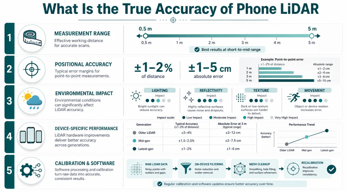
Decision-makers usually ask the right question quickly: accurate enough for what? That is exactly the right framing, because phone LiDAR is not one thing across all scales.
The research is better than the hype and less flattering than the hype
The most useful UK-relevant summary in the supplied material comes from Esri UK. It cites peer-reviewed smartphone LiDAR research showing that an iPhone 12 Pro achieved ±1 cm accuracy for small objects larger than 10 cm, while a coastal cliff model up to 130 × 15 × 10 m was reconstructed with ±10 cm accuracy. In a separate building documentation study using iPhone 13 Pro apps, practical accuracies were 10–20 cm at the 95% confidence level, and no app achieved 95% of distances within 5 cm. That is a very useful benchmark for venue operators considering asset capture or documentation workflows, as set out in Esri UK's review of LiDAR on a phone.
Those numbers tell a clear story. The sensor can be impressively accurate at small scale. As the scene gets larger and messier, the practical accuracy moves.
What those figures mean in operational terms
If you're documenting a small piece of fixed infrastructure, a local scan can be good enough to answer practical questions. You might use it to check clearance around a gate line, capture the geometry of a kiosk location, or create a quick reference model of a service room.
If you're trying to model a large concourse, complex interchange, or long route network to a level suitable for detailed architectural or engineering decisions, the tolerance gap becomes more important. A 10–20 cm practical accuracy band may be acceptable for some operational records and completely inadequate for other tasks.
A useful way to understand this is:
| Task | Is phone LiDAR likely to be suitable |
|---|---|
| Quick room capture for reference | Often yes |
| Approximate asset location documentation | Often yes, with checking |
| Accessibility route review support | Potentially, if combined with other verification |
| Detailed architectural measurement | Often no |
| Engineering-grade survey replacement | No |
A more technical overview of 3D LiDAR scanning in mapping workflows can help if your team is comparing mobile capture against more formal survey methods.
Accuracy is never just about the sensor
A senior operator shouldn't only ask, "What is the headline accuracy?" They should also ask:
- What is being measured? A door reveal, a platform edge zone, and a whole concourse are different problems.
- What app is processing the data? Software choices affect what gets reconstructed and how.
- Who is doing the capture? A careful survey technician and a busy duty manager won't produce identical outputs.
- What decision will the model support? A rough maintenance reference and a design sign-off require very different confidence.
Operational implication: If a wrong dimension would force rework, create risk, or mislead an accessibility decision, don't rely on a phone scan alone.
Where transport hubs need discipline
Large public venues are full of compounding issues. People move. Queues form. Temporary barriers appear. Cleaning equipment gets parked in the wrong place. Reflections, glazing, and repetitive surfaces can confuse capture. Even when the underlying sensor is capable, the working conditions are unstable.
That doesn't make phone LiDAR poor. It makes it contextual.
For transport hubs, the best use of the technology is usually targeted, bounded, and verified. Use it where speed matters and where a modest tolerance is acceptable. Don't pretend it has become a substitute for professional survey control or for a maintained digital representation of the venue.
Where Phone LiDAR Fails and Where It Excels
For a major venue, the fastest way to evaluate phones with LiDAR is to separate capture convenience from operational dependence. Those are not the same thing.

Where it earns its place
Phone LiDAR is useful when you need a quick, local understanding of space without bringing in specialist kit. In that role, it can be practical.
Good fits include:
- Back-of-house documentation: Plant rooms, service corridors, staff-only areas, and smaller enclosed spaces are often manageable scanning targets.
- Rapid site notes: Teams can capture a 3D reference of a changed area instead of relying only on photos and memory.
- Early accessibility reviews: A route, threshold, doorway, or circulation pinch point can be documented for discussion before more formal validation.
- Temporary condition recording: If a layout has been altered for works, events, or rerouted passenger flow, a quick local scan can help teams coordinate.
These are all bounded tasks. The phone doesn't need to understand the whole estate. It just needs to capture enough of the immediate environment to support a workflow.
Where it starts to break down
The failures are usually predictable.
First, phone LiDAR only captures what is visible from the user's position. In a live station, crowds, queues, trolleys, pop-up retail, cleaning equipment, and temporary barriers all obstruct that view. The device cannot scan through people.
Second, public venues aren't static. A good scan today can be a misleading scan after a concession fit-out, a platform works programme, or a revised queuing arrangement. That matters if teams start treating ad hoc scans as durable truth.
Third, the phone form factor imposes compromises. A member of staff walking quickly through a live environment is unlikely to deliver the same consistency as a dedicated capture process.
For large venues, phone LiDAR is strongest when the question is local and immediate. It is weakest when the problem is network-wide, dynamic, and operationally critical.
A simple comparison for venue teams
Consider the difference between these two scenarios.
A property team wants to record the geometry of a newly installed ticket counter and adjacent circulation space. Phone LiDAR can help create a quick spatial record.
An operations team wants to provide dependable passenger guidance across entrances, gatelines, escalators, lifts, platforms, and diversion routes during disruption. Phone LiDAR alone doesn't answer that problem.
The trade-off is straightforward:
| Situation | What works | What doesn't |
|---|---|---|
| Small, fixed, accessible area | Fast mobile scan | Assuming survey-grade precision |
| Local asset capture | Convenient staff workflow | Long-term reliance without validation |
| Live concourse with crowds | Partial capture at best | Treating occluded areas as complete |
| Venue-wide navigation | Supplementary input | Using LiDAR alone as the navigation basis |
Cost and device reality matter
There is also a procurement issue that gets ignored. LiDAR has been concentrated in Apple's higher-end devices in the supplied material, not across the full smartphone market. For a public venue, that affects equity, rollout planning, and support. A workflow that depends on premium handsets is very different from one that works across ordinary phones already in users' pockets.
That is often the dividing line between a promising technical demonstration and something an operator can support across departments, contractors, and the travelling public.
How LiDAR Integrates with a True Wayfinding Solution
A sensor is not a wayfinding system. It is one input into a much larger operational stack.
For a transport hub, a true wayfinding solution has to answer harder questions than a scanner does. Can it guide someone from the street to the correct entrance, through ticketing, around disruption, and on to the right platform or gate? Can it do that consistently across different phone models? Can it support blind and low-vision travellers as well as the general public? Can your team update it when the environment changes?
What a working system actually needs
A deployable navigation service for a large venue usually needs four things working together:
- Reliable positioning logic that doesn't collapse in signal-poor areas.
- A maintained map model that reflects the operational reality of the site.
- User experience design that works under stress, time pressure, and accessibility needs.
- A practical update process so the digital layer doesn't drift away from the physical one.
LiDAR can help with parts of mapping and capture. It does not, by itself, solve all four.
Why hardware dependence becomes a public-access problem
If a wayfinding service depends on LiDAR-enabled phones, you narrow who can use it. In a consumer app, that may be acceptable. In a public transport environment, it usually isn't.
That is one reason many operators should treat LiDAR as optional support rather than a mandatory foundation. A system that only works properly for people with premium devices creates an inclusion gap before the journey even begins.
Waymap approaches this differently. Its navigation uses the standard motion sensors already present in smartphones, combining accelerometer and gyroscope data with detailed mapped environments rather than depending on LiDAR on the user's device. For operators assessing mapping and navigation for complex venues, that matters because the deployment question isn't just technical. It's also about reach, maintainability, and accessibility.
A good navigation service doesn't ask the public to own specialist hardware. It should meet people where they are.
Where LiDAR still fits sensibly
That doesn't mean LiDAR has no role. It can be useful in the creation or update of mapped environments, in local documentation, and in certain specialist workflows where teams need quick 3D context.
But there is a difference between using LiDAR in the workflow and requiring LiDAR for the service. For major venues, that distinction is decisive.
If you run a transport hub, the strategic question isn't whether phones with LiDAR are impressive. It's whether your navigation and accessibility model remains dependable when the station is crowded, the signal is poor, and the traveller is anxious, distracted, or visually impaired. That standard is much higher than "the phone can scan a room."
Next Steps for Evaluating LiDAR-Enabled Devices
Start with the operational problem, not the handset specification. If your issue is poor asset records in plant spaces, phone LiDAR may be worth trialling. If your issue is reliable navigation for passengers across a complex interchange, a LiDAR-enabled phone may be peripheral to the core solution.
A sensible evaluation process usually starts with a short set of questions.
Questions worth asking before any pilot
- What exact task are we testing? Room capture, accessibility audit support, local asset documentation, or public wayfinding all require different success criteria.
- What level of error can we tolerate? If small deviations change decisions, you need a stricter validation process.
- Who will capture and maintain the data? A tool that works only when a specialist is present often won't survive operational reality.
- What happens when the venue changes? Retail churn, engineering works, and temporary barriers all test whether the system stays usable.
- Who owns the captured data and derived models? This affects procurement, security review, and long-term flexibility.
- Does the workflow depend on premium devices? If yes, your cost and accessibility assumptions need to be explicit.
Keep the pilot narrow and measurable
Avoid broad pilots with vague aims. Pick a contained operational use case. A plant room. A circulation change area. A small accessibility review zone. Then compare the output against the level of trust the task requires.
If your team is still weighing simple measurement use cases, a practical external comparison can help you find the right app for property measurements before you decide whether you need a lightweight capture tool, a specialist survey process, or a full navigation platform.
What good procurement looks like
Good procurement doesn't ask whether LiDAR is the future. It asks whether a specific workflow becomes more reliable, more maintainable, and more inclusive with the technology in place.
For large public venues, that's the standard to keep. Not novelty. Not device hype. Just operational fit.
Frequently Asked Questions About Phone LiDAR
| Question | Answer |
|---|---|
| Do all modern smartphones have LiDAR? | No. In the supplied material, LiDAR is associated mainly with Apple's high-end Pro devices rather than the full smartphone market, so it shouldn't be treated as a universal handset feature. |
| Are phones with LiDAR accurate enough for professional use? | Sometimes. They can be useful for bounded capture and documentation tasks, but suitability depends on the scale of the scene and the tolerance your workflow requires. |
| Can phone LiDAR replace professional surveying equipment? | No. It's useful for quick capture and approximate documentation in the right context, but it isn't a substitute when survey control or high precision is required. |
| Is phone LiDAR good for indoor wayfinding on its own? | No. It can help capture spatial information, but dependable wayfinding needs maintained maps, positioning logic, and an interface designed for real users in live environments. |
| Does LiDAR work well in crowded public spaces? | Not reliably as a sole basis for capture. People, queues, temporary barriers, and constant change limit what the phone can see and model. |
| Is LiDAR mainly a consumer novelty? | No, but it is often marketed that way. For venue operators, its stronger uses are usually in documentation, mapping support, and local spatial capture rather than entertainment features. |
| Should a transport hub standardise on LiDAR-enabled phones? | Not automatically. That decision only makes sense if the workflow clearly benefits and if the device requirement doesn't create cost, support, or accessibility problems. |
Does phone LiDAR help accessibility work?
Yes, but only in a supporting role. It can help teams document physical layouts, circulation pinch points, and route conditions more richly than flat photography alone.
What it doesn't do is turn that information into dependable guidance by itself. Accessibility in a transport hub depends on maintained route logic, clear user instructions, and a service that works for people regardless of whether they carry a premium handset.
Is phone LiDAR suitable for mapping an entire station or airport terminal?
Not as a standalone method if you need dependable, maintained, operationally trusted outputs. A phone can capture sections of a large venue, but scaling that into a coherent estate-wide model is a different challenge.
The bigger the site, the more issues you face with occlusion, inconsistency, change over time, and variable capture practice.
Does LiDAR raise privacy or governance concerns?
Yes. Any workflow that captures detailed spatial information in public or semi-public areas needs governance. Operators should review what is being captured, where it is stored, who can access it, and how long it is retained.
That matters even more in transport, healthcare, and other regulated environments where the line between useful documentation and problematic over-capture can be thin.
What is the best way to test phones with LiDAR in a venue?
Run a tightly defined operational pilot. Choose one use case, one area, one responsible team, and one validation method.
Don't ask the pilot to prove everything. Ask it to answer one practical question clearly: does this device-based workflow improve a specific task without creating new maintenance, accessibility, or governance problems?
If you're assessing navigation, accessibility, or mapping in a complex venue, Waymap is worth reviewing as part of that decision. The key question isn't whether a phone has LiDAR. It's whether your chosen system can guide real people accurately through real environments, including stations and hubs where GPS, Wi-Fi, and installed hardware don't give you a dependable answer.
