
Indoor Navigation Beacons: How They Work and When
Installing indoor navigation beacons is often presented as the straightforward answer to poor wayfinding. It isn't. Bluetooth Low Energy hardware can support accurate indoor positioning, but the installation only creates a signal layer. The organisation still has to maintain the devices, keep maps current, test routes with different disabled users, and prove that people can reach the right door, platform, clinic, or gate.
For estates managers, transport operators and venue teams, the important question isn't whether indoor navigation beacons work. It's whether a beacon-dependent system will remain accurate, accessible and operationally sustainable after the launch project ends.
Why Installing Beacons Does Not Guarantee Navigation
A beacon network can tell a phone something about its location. It doesn't automatically understand whether a route is usable for a wheelchair user, whether a lift is operating, or whether a corridor has been closed for building work. Positioning is only one part of navigation.
That distinction matters in an NHS estate, where capital approval can be difficult and facilities teams already manage complex buildings, contractors and clinical priorities. It matters in a metro network, where hardware is exposed to dust, vibration, passenger traffic and restricted maintenance windows. In a shopping centre, the accessibility benefit has to justify an operational system that staff can keep accurate while tenants, hoardings and layouts change.
The UK indoor navigation market was estimated at nearly £30.5 billion by 2022, while Deloitte expected 25% of journeys made with navigation-app assistance to involve indoor journeys by the same year, according to a UK parliamentary evidence summary on indoor navigation. Those figures show why the purchasing decision matters, but market size doesn't turn an installation into a service outcome.
The installation is not the user experience
A person navigating a hospital doesn't experience RSSI readings or trilateration. They experience instructions. Those instructions need to account for entrances, accessible doors, lifts, stairs, crossings, temporary closures and the user's chosen destination.
Wayfindr's Open Standard recognises BLE beacons as a method for indoor positioning and navigation, and covers environmental features, mobile applications, installation, configuration and maintenance in complex spaces such as stations and shopping centres. The standard is useful precisely because hardware alone isn't the complete system. Wayfindr's audio-navigation guidance places beacons within a broader service that includes the environment and the app.
Practical rule: Treat beacons as infrastructure, not as accessibility compliance.
Organisations also need to consider the Equality Act 2010, BS 8300 and the UN Convention on the Rights of Persons with Disabilities. These frameworks point decision-makers towards accessible services and environments. They don't make a particular positioning technology sufficient by itself.
A Waymap mapping and navigation overview is useful for comparing the map layer with the positioning layer. The map must represent the venue accurately, and the navigation service must continue to work when physical conditions change.
How Indoor Navigation Beacons Actually Work
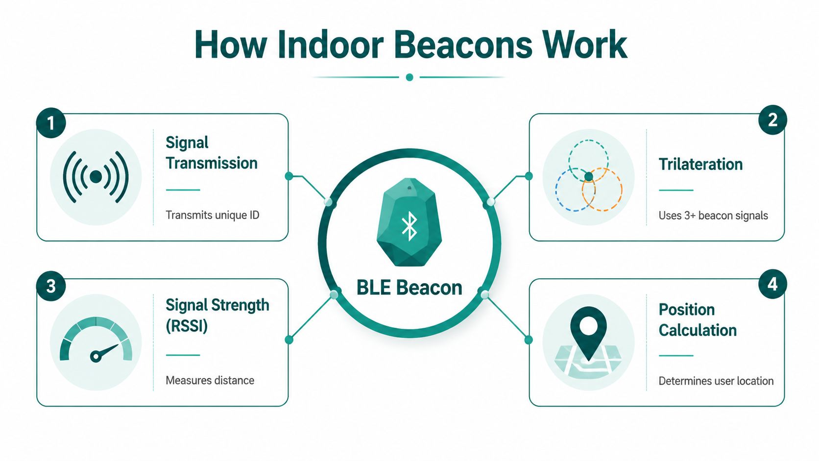
Bluetooth Low Energy beacons are small transmitters that repeatedly broadcast an identifier. A smartphone detects nearby broadcasts and records the received signal strength, commonly called RSSI. The positioning engine uses the pattern of signals from several beacons to estimate where the phone is.
A simple analogy is standing in a room while several people call your name. If one voice sounds loud, another quieter and a third faint, you can make a rough estimate of your location. A phone performs a similar calculation with radio signals, although walls, bodies, metal structures and reflections make the environment much less tidy than the analogy suggests.
From signal strength to a position
A conventional workflow looks like this:
- Signal transmission: Each beacon sends a unique identifier at configured intervals.
- Signal collection: The phone listens for nearby identifiers and measures RSSI.
- Distance estimation: The system estimates relative distance from signal attenuation, recognising that radio power doesn't decline predictably in every building.
- Position calculation: An algorithm combines multiple readings to place the phone on an indoor map.
- Route guidance: The navigation layer matches that position to a walkable route and provides instructions.
Some systems use trilateration, which estimates a position from overlapping distance ranges around several reference points. Other approaches build a radio map by recording signal patterns across the venue, then compare the user's measurements with that map. In both cases, the quality of the result depends on the placement of the hardware and the conditions in which the signals are received.
A UK study from Liverpool John Moores University reported positioning accuracy between 0.2 m and 0.35 m, with average errors as low as 0.333 m and maximum errors below 1.01 m, depending on the method used. A separate UK study of shoppers in a large wholesale environment reported about 2.5 m accuracy with beacon density of roughly 30 m² per beacon, illustrating the difference between controlled testing and an active venue. These results are documented in UK research on beacon-based spatial signal mapping.
Why placement changes performance
The University of Cambridge found that a dense BLE layout of about one beacon per 30 m² produced one-shot positioning error below 2.6 m for 95% of fixes. Reducing density to one beacon per 100 m² worsened the 95th-percentile error to below 4.8 m, while an established Wi-Fi network in the same test area produced error below 8.5 m for 95% of fixes. The Cambridge indoor-positioning paper shows that density is not a cosmetic deployment choice. It directly affects usable accuracy.
Line of sight also matters. Research from Queen's University Belfast found roughly 0.6 m average error in a line-of-sight test within 3 m, with more than 90% localisation accuracy regardless of beacon attachment location. That supports flexible mounting, but it doesn't remove the effects of close-range geometry, obstructions or difficult doorways. A Waymap explanation of indoor location tracking provides a useful comparison between location detection and the wider navigation task.
The Hidden Costs of Beacon Infrastructure
The purchase order is usually the easiest part of a beacon project. The difficult work starts when the venue has to keep the system reliable.
Accuracy depends on enough devices being in the right places. The Cambridge research cited above showed materially different results between a layout of one beacon per 30 m² and one beacon per 100 m². A large transport hub therefore isn't choosing between a handful of inexpensive tags and no tags. It is deciding how much physical infrastructure is needed across platforms, concourses, passageways, entrances and vertical transitions.
Maintenance is a facilities responsibility
Battery-powered hardware avoids cabling, but it doesn't avoid maintenance. Estates teams need an inventory, a replacement process, access arrangements and a way to identify devices that have stopped transmitting. In a high-ceiling station or a busy shopping centre, reaching a device may require specialist access equipment, isolation procedures or a maintenance window outside normal operating hours.
The same problem appears in hospitals. A beacon installed in a quiet corridor may become inaccessible after a refurbishment, new partition or change in clinical use. If a device is moved but the map and positioning model aren't updated, the system can continue to look operational while giving unreliable guidance.
The cost of a beacon network isn't just the tag. It's the repeatable process for inspecting, replacing, validating and documenting every tag.
Firmware and configuration create another layer of work. Operators need to know which devices are deployed, which settings they use and whether a change affects positioning behaviour. The challenge grows across a multi-building campus or transport network because a procedure that works in one wing may become unwieldy when teams must coordinate access across many sites.
Total cost of ownership is broader than hardware
A proper business case should include:
- Site surveys: Mapping signal behaviour and identifying difficult areas before installation.
- Installation labour: Mounting devices, recording their locations and checking coverage.
- Ongoing access: Reaching devices in operational buildings without disrupting services.
- Battery replacement: Scheduling and documenting physical interventions.
- Map and route updates: Reflecting closures, construction, tenant changes and lift outages.
- Accessibility testing: Checking that instructions work for different mobility and sensory needs.
- Decommissioning: Removing or relocating devices when a space changes.
The Waymap discussion of Bluetooth access points helps frame the central procurement question. A venue should compare the full operational commitment of installed hardware with alternatives that use existing smartphones and venue maps.
This doesn't mean beacon infrastructure is always unaffordable or unsuitable. It means the buyer should ask who owns the network after launch, how quickly faults are detected, and whether the venue has the capacity to maintain reliable coverage for the life of the service.
Beacon-Based Positioning Versus Infrastructure-Free Alternatives
Beacon-based positioning and infrastructure-free navigation solve different parts of the indoor-location problem.
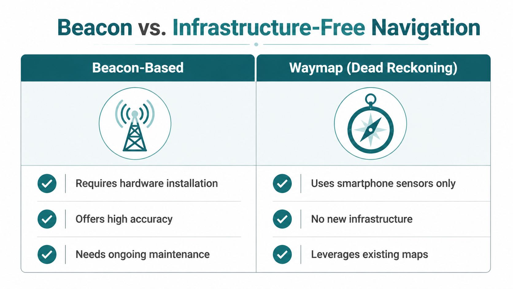
A beacon system adds reference points to the environment. It can provide strong positioning where the network is dense, correctly installed and maintained. An infrastructure-free approach uses the phone's own sensors, a detailed map and software that estimates movement from device-native motion data. Waymap describes this as dead reckoning using smartphone sensors, with sub-3-metre accuracy in infrastructure-free environments and no pre-mapping requirement for venues with high staff turnover or frequent layout changes.
The practical comparison
| Decision factor | Beacon-based positioning | Infrastructure-free navigation |
|---|---|---|
| Physical deployment | Requires venue-installed devices | Uses smartphone motion sensors |
| Signal dependency | Depends on beacon coverage and signal conditions | Doesn't depend on BLE, Wi-Fi or GPS |
| Accuracy | Improves with suitable density and geometry | Depends on sensor fusion, map quality and movement estimation |
| Layout changes | May require hardware and model validation | Map and route updates can be handled in software |
| Maintenance | Includes device, battery and access management | Removes the beacon maintenance layer |
| Challenging environments | Can work well where coverage is maintained | Suits underground and signal-poor environments |
Waymap's underlying mechanism combines device-native sensors with detailed maps, rather than asking the venue to install a new positioning network. Its navigation can provide room-level guidance across floors, corridors and rooms without a beacon. The Waymap sensor-fusion algorithm is relevant when a buyer wants to understand how movement estimation differs from signal-based positioning.
When beacons still make sense
Beacons can be appropriate when a venue already has an established maintenance capability, needs a location layer for several operational applications, or has stable spaces where device placement can be protected and checked. They may also complement other systems where a particular doorway or zone requires a fixed reference.
Infrastructure-free navigation is more attractive when capital expenditure is constrained, layouts change often, or physical access is difficult. It also avoids adding hardware to places where the operator can't guarantee ongoing inspection. Deployments associated with WMATA, SBS Transit and Westfield London illustrate the type of transit and large-venue context in which infrastructure-free navigation can be evaluated.
The right comparison isn't "which technology has the smallest positioning error in a test?" It is "which service can provide usable, accessible routes under the conditions this venue can maintain?"
Accessibility Compliance Requires More Than Hardware Installation
An accessible navigation service must guide people along an admissible route, not merely calculate a coordinate.
That route may need to avoid stairs, use a working lift, provide information about a blocked corridor and identify an accessible entrance that differs from the main entrance. A system designed only around blind and low-vision users can still fail wheelchair users, Deaf or hard-of-hearing people, and people with cognitive or learning disabilities if it doesn't communicate the information they need at the point of decision.
UK guidance on accessible indoor navigation says meaningful testing should include those groups because their route requirements differ. It also highlights temporary barriers, including blocked corridors and lift outages, which must be communicated during the journey. The UK accessibility guidance discussed in relation to beacon trials makes the service-outcome gap clear.
Test the route, not the equipment
A venue should test:
- Entry: Can users locate and use the accessible entrance?
- Orientation: Can they understand the starting instruction without relying on visual signage?
- Vertical movement: Does the route select an available lift where stairs aren't suitable?
- Obstacles: Does the system respond when a corridor, door or lift is temporarily unavailable?
- Instruction format: Can users receive information in a way that suits their sensory and cognitive needs?
- Fallback: Is there a clear way to obtain human assistance when the digital route can't resolve a problem?
BS 8300 provides a UK built-environment accessibility anchor, but compliance isn't demonstrated by attaching devices to walls. Positioning quality needs evaluation in the actual venue, with its real obstructions, surfaces, crowds and route conditions. The same principle applies to the Equality Act 2010 and the UN Convention on the Rights of Persons with Disabilities. Both make the organisation's responsibility broader than purchasing technology.
Accessibility test: Ask whether the service can explain and update the route a person can use, not whether the phone can see a blue dot.
Wayfindr's Open Standard is designed for blind and vision-impaired users in complex environments and recognises BLE beacons as one method for accessible audio navigation. It also covers environmental design, mobile application features and implementation guidance. That is a useful foundation, but operators still need to test the complete service with representative users.
An infrastructure-free system can reduce the physical maintenance burden and adapt to walking styles through sensor-based movement estimation. It doesn't remove the need for accessible mapping, route governance, user research or human fallback. No positioning method can make an inaccessible route accessible by itself.
Real Deployments and What They Reveal
Gatwick Airport illustrates why an operator might choose indoor navigation beacons. The airport said GPS-based road navigation systems are unreliable indoors because satellite signals aren't available, so it deployed a beacon-based positioning system to provide a reliable blue dot on indoor maps that could later support multiple mobile applications. The Gatwick indoor-navigation example shows a clear operational rationale. The airport needed positioning inside a large, complex environment where outdoor navigation technology couldn't provide it.

The lesson isn't that every airport should install beacons. It is that the deployment decision followed a defined gap between the navigation service passengers needed and the technology available indoors. Procurement teams should apply the same discipline to hospitals, stations, campuses and retail sites.
Venue conditions determine the answer
A permanent beacon network can work in a stable terminal or hospital zone when the operator can maintain coverage and validate routes. Transit hubs and shopping centres introduce harder conditions. Passenger flows, construction work, retail refits, temporary barriers and altered entrances can make a static positioning layer drift away from the environment it represents.
Lord's Cricket Ground has been presented as a world-first stadium implementation of infrastructure-free navigation. A stadium is a useful test case because visitor routes, entrances and event conditions can change, while staff and visitor turnover makes a permanent physical network difficult to manage. The WMATA deployment case study provides another named transit context for evaluating navigation without treating a beacon installation as the default answer.
Operators assessing navigation alongside wider building systems can also review Faberwork LLC's smart building automation results for context on how operational technology projects are evaluated beyond a single device or feature.
The practical conclusion is straightforward. A beacon network may be justified when fixed reference points solve a defined operational problem and the owner can maintain them. A beaconless approach may fit better where the venue changes frequently, access is difficult, or the operator needs a navigation layer that can be updated in software.
Evaluating Indoor Navigation for Your Venue
Start with the route, not the hardware catalogue. Document the destinations users need, the accessible routes available, the temporary disruptions that occur and the staff process for updating them.
Then assess five questions:
- Environment: Is the venue stable, or do layouts and access routes change regularly?
- Maintenance: Can the organisation inspect, replace and validate physical devices?
- Accessibility: Will testing include wheelchair users, Deaf or hard-of-hearing people, blind and low-vision users, and people with cognitive or learning disabilities?
- Integration: Can the system connect to maps, facilities workflows and disruption information?
- Evidence: Can the supplier demonstrate performance in the actual venue rather than rely on laboratory results?
Different organisations will reach different conclusions. Waymap deployments and work involving the Royal Hospital for Children and Young People, CapMetro Austin and LTA Singapore show why venue type, transit operations and campus conditions need separate evaluation. Ask for a venue-specific demonstration and measure route completion, instruction clarity, disruption handling and user confidence against your accessibility objectives.
Waymap provides indoor, outdoor and underground navigation without GPS, Wi-Fi or installed hardware, using smartphone motion sensors, detailed maps and adaptive audio guidance. Visit Waymap to discuss a venue-specific demonstration and assess whether an infrastructure-free approach fits your accessibility and maintenance requirements.
