
Future Mapping Company: Indoor Navigation Beyond GPS
Ever found yourself lost in a sprawling airport or a maze-like underground station? That moment your phone’s map goes blank just when you need it most? That’s the hard limit of GPS. A future mapping company like ours is dedicated to solving that problem by creating the next digital layer for our cities and mapping the great indoors.
Moving Beyond GPS With a Future Mapping Company
We’ve all come to rely on GPS to get us from A to B out on the streets. But the second you step inside a large, complex building, that reliable signal often vanishes. This is where our work begins. We specialize in creating highly detailed and accurate maps for all the spaces between the roads.
This isn't just about putting a pin on a floor plan. It’s about creating live, step-by-step directions that work flawlessly where satellites can’t reach. Think of it as a seamless journey that starts on the street and continues right to your seat, gate, or platform once you’re inside a transit hub, shopping center, or university campus. We’re making the indoor world just as navigable as the outside.
A New Approach to Digital Mapping
At Waymap, our approach is built on a powerful, sensible idea: the best technology is the one you already own. We use the sensors already built into every smartphone—the accelerometer, gyroscope, and compass—to pinpoint a user’s movement and location with remarkable accuracy. This simple shift means our system requires no extra hardware at all.
This infrastructure-free approach is what sets us apart from older systems that rely on a network of physical Bluetooth beacons. Those traditional methods are often unworkable for many organizations because of their drawbacks:
- High Upfront Costs: Buying and installing hundreds, sometimes thousands, of beacons is a major capital investment.
- Constant Maintenance: Beacons need battery replacements, break down, and require constant monitoring. It’s a never-ending operational challenge.
- Difficult to Scale: Want to expand coverage to another part of the building or a new campus? You have to repeat the entire costly and slow installation process.
By using just software and the phone in a person’s pocket, a true future mapping company makes advanced indoor navigation practical and affordable for any venue.
Our philosophy is straightforward: by creating a system that works perfectly without any extra hardware, we deliver a solution that is not only more cost-effective but also infinitely more scalable and easier to maintain. This opens the door for widespread adoption across all types of public venues.
This focus on a software-first solution has profound benefits. It means a hospital can update its internal map instantly when a department moves. A transport authority can add a temporary route for a special event with a few clicks. This is the kind of flexibility needed to build the smart, responsive public spaces of tomorrow.
Ultimately, it’s about more than convenience. It’s about building a foundational technology that creates more efficient, accessible, and inclusive environments, ensuring that everyone can travel with confidence.
The Technology Behind Next-Generation Wayfinding
So, how does a phone navigate you indoors without GPS or any special hardware? It all comes down to a clever technology called sensor fusion. The best way to think about it is to consider how you know where you are.
Your brain is constantly blending information from your inner ear for balance, your eyes for seeing what’s ahead, and even the feeling of your feet on the ground. You don’t think about it; you just know which way you’re moving. Our algorithm does something very similar, but for your smartphone.
It takes the stream of data from the phone's built-in sensors—the accelerometer (tracking motion), the gyroscope (sensing orientation), and the digital compass (finding north)—and fuses them together. By synthesizing these inputs, the system works out a user’s exact position, direction, and pace with high accuracy, all without needing an external signal.
Infrastructure-Free Versus Beacon-Based Systems
This sensor-first approach is a world away from the older methods of indoor navigation. For years, a common solution was to install hundreds, sometimes thousands, of physical Bluetooth beacons in a building.
These small devices act like digital lighthouses, constantly broadcasting a signal. A phone picks up these signals and uses them to estimate its approximate location. It can work, but it’s an expensive fix, creating a huge challenge for any organization that has to install and maintain them. A true future mapping company needs to be smarter than that.
The flowchart below shows how this modern approach closes the GPS gap, creating truly smart, navigable indoor spaces.
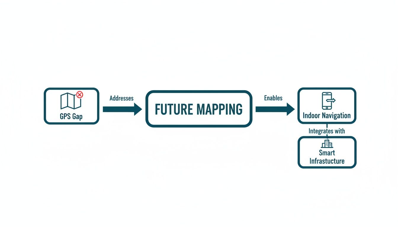
As you can see, the aim isn't just about solving a routing problem. It’s about adding a whole new layer of digital utility to the buildings we use every day, making our public spaces more connected and responsive.
By getting rid of external hardware, we cut costs dramatically, speed up deployment, and build a system that can scale to any size. It’s what makes genuinely accessible navigation a practical reality for any venue, not just a select few.
This shift is significant. It means precision wayfinding is no longer something only a huge international airport with a deep budget can afford. It’s now a completely viable and cost-effective option for local libraries, university campuses, or shopping centers—anywhere that wants to give visitors a better, more inclusive experience. To see just how far things have come, you can discover more about the evolution of technology in mapping.
To really understand the difference, let’s compare the two approaches directly.
Navigation Technology: A Head-to-Head Comparison
| Feature | Infrastructure-Free (e.g., Waymap) | Beacon-Based Systems |
|---|---|---|
| Accuracy | High (1-3 metres), consistent performance | Variable, prone to signal interference |
| Hardware | None. Uses the phone's existing sensors | Requires hundreds or thousands of beacons |
| Cost | Low setup and operational costs | High initial investment and ongoing maintenance |
| Deployment | Fast, purely software-based setup | Slow, requires physical installation by technicians |
| Maintenance | Minimal, with updates managed remotely | Constant battery replacements and recalibration |
| Scalability | Infinitely scalable across any venue or city | Limited by hardware budget and physical space |
The table makes it clear: while beacons were a necessary first step, sensor fusion is the leap forward that makes indoor navigation practical for everyone.
The Power of a Software-Only Solution
Going with a pure software solution provides an agility that hardware-bound systems simply can't offer. Venues are not static; they are constantly in flux. New wings get built, rooms are repurposed, and shops or services move.
With a beacon-based system, every change often means calling out technicians to physically move, re-calibrate, or install new hardware. It’s slow, expensive, and causes a lot of disruption. Crafting truly modern wayfinding often requires deep expertise in custom software development to overcome these old-school limitations.
In stark contrast, our software-defined mapping lets a venue manager push updates instantly through a simple web portal. That kind of flexibility is essential for creating a genuinely dynamic and helpful environment for every single visitor.
The technology behind future mapping is clever, but what really matters is the difference it makes in people's lives. This isn't about algorithms for their own sake; it’s about solving real, human problems.
For a transport operator, it’s about giving a visually impaired passenger the confidence to navigate a sprawling, multi-level station and get right to their platform. A journey that might once have been stressful and uncertain becomes simple and predictable. For a stadium manager, it’s about helping a family find their seats, the nearest accessible toilet, and a bite to eat, all without missing the action.
In both cases, the technology just works. What’s left is a feeling of independence and confidence.

Creating Seamless Journeys in Complex Spaces
The potential applications are as varied as the places we visit. Any large, public space with a confusing layout can benefit from clear, accurate indoor navigation that works for everyone.
Just think about the sheer scale of some modern buildings. A major airport can feel like a small city, and even a familiar shopping center can be disorienting in a hurry. These are exactly the places where old-school wayfinding, like static signs, simply can’t keep up.
This is where the technology really shines, making a tangible difference in places like:
- Public Transit Hubs: Getting from the station entrance to a specific platform, often deep underground, is a common challenge. Future mapping provides a continuous thread of guidance, leading you through ticket barriers, down escalators, and along corridors.
- Sprawling Campuses: We can map entire university campuses, inside and out. A student can get directions from a lecture hall in one building straight to a quiet study room in the library across the grounds.
- Shopping Centers: For retailers, it’s a powerful tool to improve the customer experience. Guiding shoppers directly to a specific store or a new sale helps them and can improve their overall experience.
- Hospitals and Healthcare Facilities: These are often stressful, confusing environments. Providing clear directions to the right ward, clinic, or department can significantly reduce anxiety for patients and their families.
In every one of these situations, an infrastructure-free approach like Waymap’s delivers a win-win: operational efficiency for the venue and a profoundly better, more dignified experience for the visitor.
A key strength here is turning what was once a complex, capital-intensive project into a cost-effective, scalable reality. Precise indoor navigation is no longer a luxury—it's now an accessible tool for genuinely improving public spaces.
From Static Signs to Dynamic Information
One of the most powerful shifts that a software-based mapping company offers is the move away from static signs to dynamic, live information. Physical signs are expensive to create, a challenge to update, and offer a one-size-fits-all solution that, in reality, fits very few.
If a shop moves in a retail center or a platform changes in a busy station, updating the physical signage is a slow and costly affair. With a system like Waymap, an operations manager can simply log into a portal and make that change instantly. The map is updated for every user, in real-time.
The immediate benefits are clear:
- Significant Cost Savings: It drastically cuts the long-term costs of printing, installing, and eventually replacing physical signs.
- Unmatched Agility: Venues can adapt on the fly. Whether for a special event, a temporary closure, or even an emergency, routes and points of interest can be updated in seconds.
- Truly Personalized Guidance: The system can provide information in multiple languages and, crucially, offer routes tailored to specific needs, like step-free access.
By replacing fixed infrastructure with a flexible digital layer, we give venue operators an incredible amount of control over their own spaces. This agility is fundamental to creating the smart, responsive buildings of the future. To see this in action, have a look at some of our Waymapped venues and explore what’s possible.
Why Inclusive Design Is an Operational Advantage
Let’s be clear: designing for accessibility isn’t a compliance task or a box-ticking exercise. It's a genuine operational advantage. When you put inclusion first, you don't just help a few people; you create a better, more functional experience for every person who walks through your doors.
At its heart, inclusive design is about accepting that people experience the world in different ways and building for that reality. Our technology was developed with this principle from day one, providing heads-up, audio-first guidance. This gives people with visual impairments the freedom to navigate complex public spaces independently and confidently.
It’s an approach that directly tackles the mobility challenges many people face in unfamiliar environments. A stressful journey becomes a simple one, opening up access to transport, retail, and community spaces. As a future mapping company, we see this as a fundamental part of our work.
More Than a Feature—It’s a Foundation
When your organization creates a genuinely inclusive experience, it sends a powerful message. It shows a deep, authentic commitment to the community you serve, moving beyond words to tangible action.
This has a direct, positive impact on your ESG (Environmental, Social, and Governance) profile. A strong social component makes you a more attractive partner for modern investors, customers, and talent, who increasingly want to align themselves with organizations that share their values.
By fulfilling accessibility mandates like the Equality Act 2010 not as an obligation but as a natural outcome of good design, you enhance your brand's reputation. It proves a simple but powerful truth: what is good for people is also good for business.
This commitment builds trust and loyalty. It shows that your venue isn't just open to all, but is actively welcoming and supportive of everyone, whatever their ability.
The Scale of the Challenge—and the Opportunity
The need for better accessibility isn't a niche issue. In the UK, visual impairment affects over 2 million people, with around 350,000 registered as blind or partially sighted. According to the Royal National Institute of Blind People (RNIB), a large majority of blind and partially sighted adults report difficulties finding their way in unfamiliar places.
Think about that. For some, huge venues like train stations and shopping centers can become no-go zones, leading to social isolation and a loss of independence. You can find out more about how new funding is addressing this navigation challenge with insights from PhocusWire.
But tackling this isn’t just about social good; it opens up your venue to a significant and often underserved part of the population. By making your space easy to navigate, you empower more people to visit, shop, and engage with your services.
The benefits ripple outwards. When a visually impaired person can navigate your venue with ease, it often means a more intuitive experience for a tourist struggling with a foreign language, a parent pushing a stroller, or a delivery driver trying to find the right service entrance. For a deeper dive into this subject, you can explore our overview of products designed for the visually impaired.
The Business Case for Universal Access
Ultimately, an investment in inclusive design delivers a clear return. When you design a system that works for those with the greatest needs, you almost always create a more robust, reliable, and user-friendly solution for your entire audience.
Consider the practical advantages:
- Reduced Staff Burden: When visitors can find their own way confidently, your staff are freed up from giving repetitive directions. They can focus on higher-value tasks instead.
- Increased Visitor Satisfaction: A seamless, stress-free visit leads to higher satisfaction scores, positive reviews, and more repeat business.
- Enhanced Brand Image: Being seen as a leader in accessibility makes your brand stand out and builds a powerful, positive reputation.
Inclusive design is a strategic choice. It positions your organization as a leader, ready for the future and committed to serving every member of your community.
How to Choose the Right Future Mapping Partner
Choosing who to trust with your venue's digital navigation is a decision that will have a long-term impact. For any city planner, venue operator, or accessibility lead, getting it right will transform your visitor experience. Getting it wrong can mean being locked into expensive hardware, endless maintenance, and a system that doesn’t work for everyone.
This isn't about ticking boxes on a feature list. It’s about asking the right questions to find a true partner—one who delivers a solution that is accurate, scalable, and genuinely inclusive for the long haul.
First, Examine the Core Technology
Before you get impressed by a demo, you need to understand the core technology. How a system actually finds its position is the single most important factor, determining everything from its cost and reliability to how flexible it will be in the future.
You need to ask some direct questions about how it all works:
- Does it rely on an expensive and disruptive installation of hardware, like thousands of Bluetooth beacons or Wi-Fi access points?
- Or does it take a modern, infrastructure-free approach, using the sensors already built into your visitors' own smartphones?
- How accurate is it? Especially in tricky signal-dead zones like basements, underground stations, or deep inside a concrete building.
A hardware-heavy approach might seem robust at first, but it often brings long-term operational pain. Beacons need constant maintenance, battery replacements, and specialist technicians every time you want to make a change. A software-only solution, like Waymap, sidesteps these problems entirely, giving you a much more agile and cost-effective foundation to build on.
Is It Built for Change?
Your venue isn't a museum piece; it’s a living space. Shops change, departments move, and temporary events demand new layouts. Your mapping solution has to keep up, instantly, without creating a mountain of work for your team or racking up service fees.
This is where you can tell a genuine partner from a simple supplier.
The best solutions put you, the operator, in the driver's seat. Letting your own staff update maps in real-time isn't a luxury—it’s an absolute necessity for any modern, dynamic space.
When looking at a potential future mapping company, dig into their process for updates. Are you tied to their service team every time a room gets a new purpose? Or are you given a simple dashboard that lets your own people make changes on the fly? A system that can't be easily updated by you is not a solution for the future.
Insist on an Inclusive-First Philosophy
The real test of any navigation system is whether it works for everyone. We believe the only way to build a truly great system is with what we call an 'inclusive-first' approach. When you design for the most challenging use case—for instance, someone navigating a complex building without sight—you create a system that is fundamentally more accurate and reliable for every single visitor.
Starting with accessibility forces better design decisions. It demands pinpoint accuracy, clear audio instructions, and routes that understand real-world obstacles like stairs or temporary barriers. This doesn’t just help people with disabilities; it helps tourists navigating in a new language, parents with strollers, and anyone trying to find their way in a hurry.
Use this as a quick check on a vendor’s commitment to real inclusivity:
- Co-Design: Was the system built with and tested extensively by people with a range of disabilities, especially those with visual impairments?
- Guidance: Does it offer ‘heads-up’, audio-first navigation, or does it force people to stare down at a screen?
- Personalization: Can it create tailored routes, like step-free options, and does it learn an individual’s walking pace to give truly personal guidance?
Vendor Evaluation Checklist
Choosing the right partner demands a methodical approach. The table below is a starting point to help you ask the tough questions during your evaluation. It's designed to cut through marketing fluff and get to the core of what a partner can really offer your organization.
| Evaluation Criteria | Key Questions to Ask |
|---|---|
| Technology & Accuracy | How does your system determine location? What is the proven accuracy in real-world deployments, especially indoors? |
| Infrastructure Needs | Does the system require beacons, Wi-Fi, or any other physical hardware to be installed and maintained? |
| Deployment & Onboarding | How long does it take to map our venue and go live? What resources are required from our team? |
| Map Management | Can our own staff update maps, points of interest, and routes instantly? Or do we need to book a service call? |
| Accessibility & Inclusion | Was the solution designed with and for people with disabilities? Does it support mandates like the Equality Act 2010? |
| Scalability | How easily can we expand coverage to new buildings, floors, or an entire campus? What are the associated costs? |
| Total Cost of Ownership | What are the full costs beyond the initial setup, including maintenance, updates, and support over five years? |
By asking these questions, you’ll be able to see which companies are just selling software, and which are ready to be a true future mapping company that equips you with a powerful tool to make your venue better for everyone.
Measuring the ROI of Smart Indoor Navigation
When considering a next-generation mapping solution, it's easy to focus on the initial cost. But this isn't just another line item in the IT budget. It's a strategic move that delivers real, measurable returns that go far beyond a simple navigation app.
To truly understand the return on investment (ROI), you need to look at the full picture. It’s a blend of direct cost savings, smarter operations, and powerful, if less tangible, benefits. This is about investing in a venue that’s more efficient, more inclusive, and ready for the future.
Quantifying Direct Cost Savings
The most obvious place to start is with the money you stop spending. Many traditional wayfinding systems come with significant and recurring costs, which a modern, hardware-free solution can eliminate from day one.
Just compare the old way with the new:
- No Hardware to Buy or Install: Beacon-based systems mean buying and installing hundreds, sometimes thousands, of physical devices. A software-only solution like Waymap has zero hardware costs. That’s a huge amount of capital expenditure that simply vanishes.
- Wiping Out Maintenance Overheads: Physical beacons need constant attention. Batteries die, devices break, and they often need recalibrating. All of that costs money, both in new parts and in staff time. An infrastructure-free system gets rid of that entire headache.
- Slashing the Spend on Physical Signage: Static signs are surprisingly expensive. You have to design them, create them, install them, and then replace them every time your venue changes. A dynamic digital map massively reduces the need for physical signs and eliminates the cost of updating them for good.
When you add up the cost of hardware, installation, ongoing maintenance, and the lifecycle of physical signs, the financial argument for a software-first approach quickly becomes compelling.
Measuring Gains in Operational Efficiency
Beyond direct savings, a smart navigation system creates powerful efficiencies by freeing up your most valuable asset: your people. When visitors can confidently find their own way, the effect for your team is immediate.
Think about how much time your staff currently spend just giving directions. In a busy airport, a sprawling hospital, or a major transit hub, this can easily add up to hundreds of hours every month. An accurate navigation app automates that task, letting your team focus on things that really matter, like genuine customer service, security, or other critical duties.
This is a fundamental shift from staff acting as human signposts to becoming value-added service providers. It’s better for morale and allows you to deliver a higher quality of service without needing to hire more people.
If you want to put a number on it, a simple time-and-motion study before and after implementation can be very effective. Tracking the drop in directional questions gives you a hard metric for the time and money saved, feeding directly into a much stronger ROI.
Tracking the Impact on Visitor Experience
A smooth, stress-free journey is a massive driver of satisfaction, loyalty, and even spending. A good future mapping partner should give you the tools to measure this, turning a better experience into data you can actually use.
A few key performance indicators (KPIs) you'll want to watch are:
- Visitor Satisfaction Scores: Use in-app prompts or post-visit surveys to see how navigation affects the overall experience. A clear uplift in satisfaction is a huge win.
- Dwell Time and Footfall: In a shopping center or retail park, guiding people to specific shops or offers can increase how long they stay and how many places they visit. Analytics can reveal clear patterns of movement and engagement.
- Reduced Missed Appointments or Departures: In healthcare or transport, getting people to the right place on time is critical. A drop in missed appointments or late arrivals is a direct measure of how well the system is working.
These numbers prove that great wayfinding isn't just a nice-to-have. It’s a tool for hitting your core objectives, whether that’s boosting revenue in a retail space or improving patient flow in a hospital.
The Long-Term Value of Social and Brand Leadership
Finally, any ROI calculation has to include the immense value of a stronger brand and a reputation for social leadership. When you commit to a truly inclusive navigation solution, you're sending a powerful message that you’re a forward-thinking, responsible organization.
This commitment has a powerful effect on:
- Strengthening ESG Credentials: A strong social profile—the 'S' in ESG—is becoming non-negotiable for investors, partners, and customers. Implementing a system designed first for people with disabilities is a tangible action that builds real brand trust.
- Enhancing Brand Reputation: Being known as a leader in accessibility and social innovation makes you stand out. It tells the world your organization cares about its entire community.
- Attracting and Retaining Talent: People want to work for companies that share their values. A clear, demonstrated commitment to inclusivity makes you a far more attractive employer.
You might not be able to put an exact monetary figure on these benefits, but they are a critical part of the overall return. They build long-term loyalty, resilience, and a brand identity that will pay dividends for years to come.
Ready to turn inclusive design into your operational advantage? At Waymap, we deliver a hardware-free, infinitely scalable navigation solution that works for everyone. Book a demo today and discover how we can help you build a more efficient, accessible, and future-ready venue.