
Mastering Toronto Underground Mall Navigation

A visitor steps off at Union Station, heads underground to stay out of the weather, and follows signs towards a meeting in the Financial District. Ten minutes later they’re still underground, standing in a food court, staring at a wall of logos and arrows that don’t seem to belong to the same system.
That isn’t a tourist mishap. It’s an operating failure. The toronto underground mall, better known as PATH, is one of the clearest examples of what happens when a major pedestrian network grows faster than its wayfinding model.
Lost in the Labyrinth a True Story of Urban Wayfinding Failure
A first-time business traveller usually enters PATH with the wrong assumption. They think they’re entering one place.
What they’ve entered is a stitched-together network of corridors, concourses, retail passages, office basements, transit links, and landlord-controlled thresholds that behave like one public system but are managed like many separate private spaces. That distinction matters the moment someone has to make a decision at speed.

Why confident visitors still get turned around
In practice, people don’t get lost because they lack signs. They get lost because the signs don’t operate as a single decision system.
A route from Union Station towards an office tower might begin with one visual language, pass through a retail-heavy zone with another, then end in a lobby where public access feels half-invited and half-tolerated. The visitor sees changing typography, different naming conventions, and abrupt transitions between spaces that all claim to be connected. None of that inspires confidence.
For a venue operator, this is familiar. Large estates often treat wayfinding as a finishing layer. Put up signs, add maps, update directories when tenants move, and assume the system is doing enough. In a small building, that approach can survive. In an underground pedestrian network, it breaks quickly.
Poor wayfinding rarely looks like a crisis from the operator’s desk. It looks like repeated small failures happening to different people all day.
The problem isn’t complexity on its own
Complex places can still be navigable. Airports prove that every day. Mainline stations do too.
A primary issue in PATH is unmanaged complexity. Users have to infer the logic of the environment while moving through it. They’re not only choosing directions. They’re trying to work out which signs still apply, whether a corridor is public, whether a lift connects where they think it does, and whether turning back will make things worse.
That’s why the toronto underground mall matters far beyond Toronto. It exposes a wider industry problem. When operators rely on static signs in a space with changing tenants, mixed ownership, and signal-poor underground conditions, navigation stops being a customer experience issue and becomes an operational risk.
What Exactly is the Toronto Underground Mall?
Calling PATH a mall understates what it is. For operators, it’s closer to an underground pedestrian transport layer with retail embedded inside it.
The scale is what forces that reframing. According to PATH’s recorded scale and economic profile), it spans 371,600 square metres of retail space across more than 30 kilometres of tunnels and walkways, connects over 75 buildings and six subway stations, sees more than 200,000 daily users, and generates approximately $1.7 billion in annual retail sales.
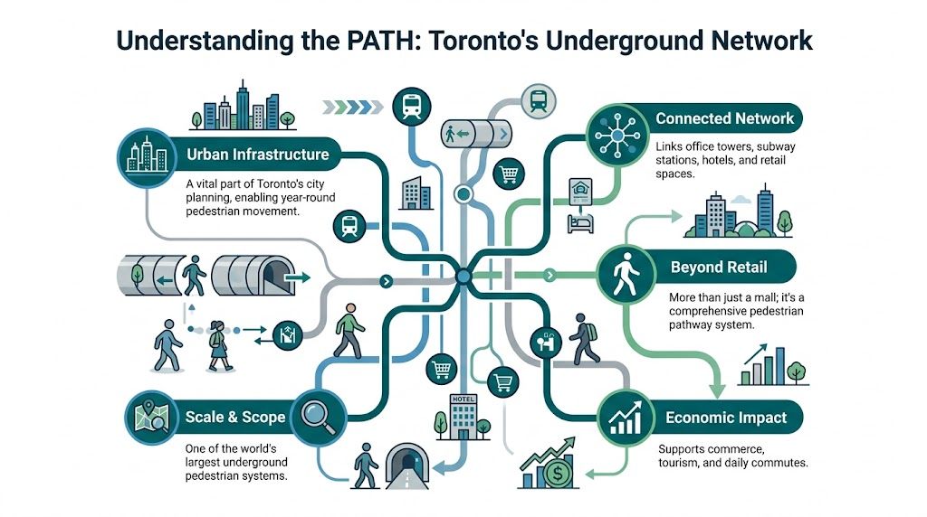
Why operators should treat it as infrastructure
Those figures put PATH in a category that facilities and mobility teams recognise immediately. This isn’t just a collection of shops below street level. It’s a movement network that supports commuting, retail access, hospitality, and venue-to-venue circulation.
That changes the operational question.
The issue isn’t whether visitors can find a coffee shop. It’s whether workers can move predictably from station to office, whether guests can reach hotels and attractions without friction, and whether footfall reaches the right places without unnecessary drop-off or congestion. In a network this large, every routing error has knock-on effects for staff demand, customer confidence, and time on site.
Its history explains its current shape
PATH didn’t arrive as one centrally designed environment. It accumulated over time.
Its origins go back to 1900, when T. Eaton Co. created a tunnel linking its main store to a bargain annex. By 1917, there were five tunnels. Union Station’s 1927 opening added another key connection. Major expansion followed in the 1960s and 1970s, when the city and private developments pushed underground links further across the core, turning basement space into commercially valuable pedestrian corridors, as described in the historical overview of PATH).
That history matters because it explains why the toronto underground mall feels uneven. It wasn’t designed in one pass for one owner with one standard. It was assembled through successive additions, each serving a local commercial purpose.
Operational reading: if a venue grows by accretion, navigation usually grows by accretion too. That’s when inconsistency becomes structural.
Why this matters outside Toronto
Many estates now resemble PATH in miniature. Hospital campuses, mixed-use developments, airports, university precincts, and regional shopping centres all contain the same ingredients. Multiple stakeholders, partial refurbishments, legacy signage, and users who expect one coherent journey.
PATH just makes the consequences harder to ignore because the network is so visible, so busy, and so economically important. If wayfinding fails here, the lesson isn’t local. It applies to any operator responsible for a complex public environment.
Why Traditional Wayfinding Fails at This Scale
Traditional wayfinding assumes three things. The environment is stable, the operator controls the estate, and the user can recover easily from mistakes.
PATH violates all three.
Its wayfinding is managed by 35 separate private landlords, with no central signage grid, and that fragmentation has stalled digital mapping pilots, according to the analysis of PATH’s fragmented management and comparable UK shopping centre barriers. The same source notes that 68% of large UK shopping centres cite multi-owner fragmentation as a key barrier to adopting unified indoor navigation technology.
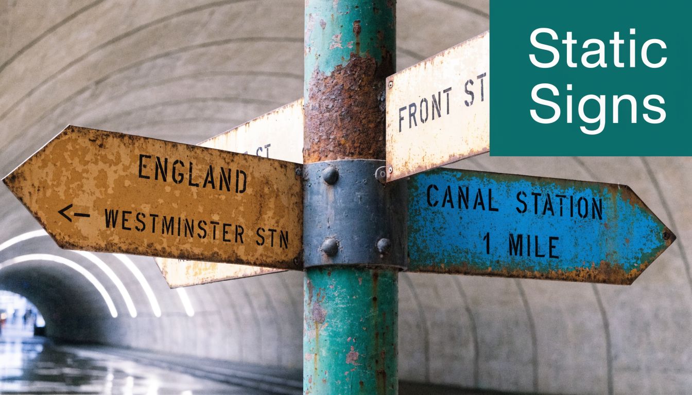
Static signs can’t manage dynamic space
A printed sign can point left or right. It can’t account for the actual conditions that shape indoor journeys.
If a tenant changes, a corridor closes temporarily, an entrance is restricted, or a lift is unavailable, static signage starts drifting out of date. In fragmented estates, updates often happen at different speeds, under different budgets, and to different standards. One landlord refreshes a directory. Another leaves an old route in place. The user gets the combined result.
That’s the first failure mode. The second is more basic. Signs only help when the user is standing where the sign designer expected them to be. If they miss one decision point, take an escalator too early, or emerge in a lobby without obvious onward cues, recovery becomes guesswork.
Fragmentation turns local decisions into network-wide confusion
The toronto underground mall behaves like one system from the visitor’s perspective. It doesn’t behave like one system administratively.
That mismatch creates predictable problems:
- Inconsistent naming: the same destination may be described differently across connected areas.
- Uneven visual standards: colours, symbols, and map styles shift from one managed zone to another.
- Abrupt edge conditions: public paths can appear to terminate in spaces that feel private or semi-private.
- Slow change control: even sensible upgrades stall when multiple owners have to agree on scope, funding, and governance.
For venue operators, that list should sound expensive. Not always in direct capital terms, but in delay, coordination effort, and user dissatisfaction.
Hardware-first upgrades often hit the same wall
Many estates try to solve the problem by adding more infrastructure. Beacons, new digital kiosks, sensor layers, and localised pilots all sound reasonable at procurement stage.
In practice, those programmes inherit the estate’s governance problems. Hardware has to be installed somewhere. Maintained by someone. Powered, secured, updated, and approved across boundaries. In a place with split ownership, that’s where progress slows down. We’ve written elsewhere about the operational limits of indoor positioning systems in real venues.
If your navigation model depends on every stakeholder approving physical changes, you don’t have a technology problem first. You have a deployment problem.
What does work better
At this scale, wayfinding has to be treated as a live operational layer, not a static estate asset.
That means a useful system should do four things. It should work across ownership boundaries, adapt without construction, support route recovery after mistakes, and remain usable in underground spaces where GPS isn’t dependable. Traditional signage can support that model, but it can’t carry it on its own.
The Human and Business Cost of Getting Lost
Most wayfinding failures never appear in a board paper under that label. They show up as service friction.
A receptionist stops handling arrivals to explain a route. Security staff become informal navigators. Retail staff answer location questions they can’t fully solve because the destination sits outside their own unit. Visitors arrive late, flustered, or give up before they reach the place they intended to visit. None of that looks dramatic on its own. Across a complex venue, it adds up.
Staff time goes first
When navigation is weak, frontline teams absorb the gap. That’s true in shopping centres, stations, hospitals, and office campuses.
The hidden cost isn’t only the interruption. It’s the unpredictability. Staff can’t plan around repeated directional queries because they rise where the environment is most confusing, not where labour is allocated. A concierge becomes a map. A cleaning operative gets stopped because they happen to be visible. A security officer gets drawn into giving directions outside their core role.
That’s one reason commercial operators care so much about clarity of movement. If you want a broader property view on customer flow and commercial performance, this piece on how malls attract shoppers and lift NOI is a useful prompt. Navigation isn’t the only variable, but it sits underneath many of them.
Accessibility failures aren’t edge cases
For people who are blind or have low vision, a sign-led environment does more than work less well. It often doesn’t work at all.
If a route depends on reading overhead boards, spotting a colour-coded branch, or interpreting a wall map, the venue has already excluded some users from independent travel. The same applies when someone with mobility needs discovers too late that a route includes an inaccessible threshold, a closed lift, or a dead end that requires backtracking.
Accessible navigation shouldn’t be treated as a specialist add-on. It’s the clearest test of whether a venue is actually navigable.
Reputation follows the journey
People remember confusion. They remember arriving late to a client meeting because the building connection didn’t make sense. They remember failing to find a retailer they intended to visit. They remember needing help in a place that looked polished but wasn’t easy to use.
For operators, that matters because navigation quality shapes how competent the venue feels. Visitors don’t separate leasing structures, property management boundaries, and signage contracts in their heads. They form one judgement. Either the place works, or it doesn’t.
That’s why poor wayfinding carries both financial and reputational cost. It reduces independence, burdens staff, weakens customer confidence, and makes a major venue feel less organised than it really is.
How Digital Wayfinding Solves Navigational Fragmentation
The operational question isn’t whether digital wayfinding is useful. In large underground estates, it clearly is. The harder question is what kind of digital wayfinding can be deployed without getting stuck in the same governance problems as physical infrastructure.
That’s where infrastructure-free models matter.

The wrong model copies the old problem
If a digital system still depends on beacons, dedicated hardware, or venue-wide installation programmes, it inherits the same delays as a signage refit. Someone has to approve every device location. Someone has to maintain the estate layer. Someone has to coordinate across landlord boundaries.
That may still be viable in a single-owner building. It’s far less practical in a network like PATH.
A better model adds a digital guidance layer without needing changes to the physical environment. That’s why we focus on hardware-free navigation. It avoids the approval bottlenecks that usually stop indoor positioning projects from moving beyond pilot stage.
Why smartphone sensor-based navigation changes deployment
Waymap is one example of that approach. It uses a smartphone’s existing motion sensors with mapped venue data to provide guidance indoors, outdoors, and underground, without relying on GPS, Wi-Fi, or installed hardware. The technical approach is outlined in how Waymap works.
For operators, the practical implication is simple. You don’t need to negotiate a hardware estate before users can benefit from the service. That matters in fragmented environments because software-based deployment is easier to govern than physical installation.
It also changes maintenance. When a point of interest moves, a route changes, or a temporary closure needs to be reflected, operators can update the digital layer without replacing signs, remounting devices, or waiting for a full refresh cycle.
What users and operators each get from it
For the user, a good digital navigation system should provide:
- Turn-by-turn clarity: not just a map, but step-based guidance through decision points.
- Recovery after errors: instructions that adapt if the person takes the wrong turn.
- Accessible delivery: audio guidance matters in underground and visually complex environments.
- Confidence in signal-poor areas: users shouldn’t lose guidance because GPS drops out.
For the operator, the gains are different:
- One navigational logic across the estate: even where ownership remains fragmented.
- Faster content updates: tenant, facility, and route changes can be reflected promptly.
- Reduced dependence on physical refresh cycles: no need to solve every navigation problem with new signs.
- A path to multilingual guidance: digital instructions can be delivered without redesigning the built environment.
The practical value of digital wayfinding isn’t that it replaces every sign. It’s that it carries the complexity signs can’t.
This is especially relevant underground
Underground pedestrian systems are where conventional assumptions fail fastest. GPS is unreliable. People can’t orient themselves by skyline or street grid. The cost of a wrong turn is often several extra decision points, not one.
That’s why PATH is such a strong case study. It shows that the toronto underground mall doesn’t need more isolated wayfinding fragments. It needs a unified navigational layer that can function across inconsistent physical settings and still give the user one coherent journey.
A Blueprint for Accessible and Navigable Venues
Operators don’t need to run a network the size of PATH to learn from it. The same decisions apply in a hospital trust, a regional mall, a transport interchange, or a mixed-use estate.
The blueprint is less about buying a product and more about choosing the right operating model.
Start with the hardest user journey
If your navigation system works for someone who is blind or has low vision, it usually works better for everyone else as well.
That’s a useful discipline because it stops teams from treating accessibility as a later overlay. It forces route logic, instruction quality, and destination naming to be precise from the outset. It also exposes where the estate itself creates avoidable barriers.
Choose technology that avoids stakeholder drag
In fragmented venues, the wrong deployment model can kill a good project.
Favour approaches that minimise estate changes, landlord approvals, and hardware maintenance. If a system needs physical intervention across multiple managed areas, delivery risk rises quickly. If you want a practical reference point for how venue teams think about digital mapping and layout readiness, our note on shopping malls and floor plans covers the issue from an operator’s side.
Treat wayfinding as an operational dataset
Static signage tells you almost nothing once it’s installed. Digital systems can do more if the implementation is disciplined.
Use route requests, destination demand, and recurring problem areas to understand where visitors struggle. That can inform staffing, tenant communication, entrance strategy, and estate planning. The point isn’t surveillance. It’s operational visibility into whether people can use the environment as designed.
A practical framework looks like this:
- Audit the actual journeys people take. Don’t start from floor plans alone. Start from entrances, hand-offs, lifts, thresholds, and common points of confusion.
- Fix destination data before interface design. If naming is inconsistent, the app or map will inherit the confusion.
- Plan for change control. Retail churn, temporary closures, and refurbishments are normal. Your wayfinding model has to absorb them.
- Measure success through independence. Fewer directional interventions from staff is often a better signal than whether a map looks polished.
A navigable venue isn’t the one with the most signage. It’s the one where people can complete journeys without needing rescue.
Frequently Asked Questions for Venue Operators
Senior teams usually ask practical questions first. They should. Navigation technology only matters if it can survive procurement, governance, and day-to-day operations.
FAQ on Digital Wayfinding Implementation
QuestionAnswerDoes digital wayfinding replace physical signage?No. It works best as a complementary layer. Physical signs still matter for orientation, compliance, and reassurance, but digital guidance handles live routing, recovery, and accessibility far better in complex estates.Is this only relevant for very large venues?No. PATH is an extreme case, but the same failure patterns appear in hospitals, campuses, stations, and shopping centres with far less square footage. Complexity matters more than size alone.What makes underground environments so difficult?GPS weakness, repeated-looking corridors, and limited natural reference points make underground movement harder. Users lose confidence quickly when every junction feels similar.Why do fragmented estates struggle with upgrades?Because every physical intervention creates coordination work. Different owners, budgets, approval routes, and maintenance standards slow down projects that would be straightforward in a single-owner venue.What should an operations team evaluate first?Start with deployment friction. If the system requires extensive hardware, landlord permissions, or long installation windows, expect delays before user benefits appear.How should accessibility be assessed?Test whether a blind or low-vision visitor can complete an unfamiliar journey independently. That reveals far more than a standard desktop review of signs and maps.Can a digital system handle frequent tenant or route changes?It should. If updates are slow or dependent on physical replacement programmes, the system will age badly in active commercial environments.What does good implementation governance look like?One owner for destination data, one process for route updates, and clear responsibility for temporary changes such as closures or lift outages. Without that, even strong technology becomes inconsistent.
The procurement question behind the technology question
Many teams ask about accuracy first. In practice, they should also ask about operability.
A technically impressive system can still fail if the venue can’t maintain its map data, update routes promptly, or govern changes across departments. That’s why implementation planning matters as much as the navigation engine itself. For a property-side view of how real estate operators present capability and accountability, the insights from JRG Property's clients are a useful reminder that client confidence often comes down to execution, not claims.
The simplest test to use internally
Ask one blunt question. Can a first-time visitor complete a critical journey independently, without reading the building’s politics?
If the answer is no, you have a service design problem, not just a wayfinding one. PATH makes that visible because of its scale, but the lesson applies almost everywhere people move through complex built environments.
If you’re reviewing navigation in a complex venue, Waymap is worth assessing alongside your current signage, mapping, and accessibility approach. The key question isn’t whether your estate has directions. It’s whether people can use them indoors, underground, and independently.